Filtered by Category:Canada(Show All Categories)
Showing results for:Auction 180
Catalog Archive
31 lots
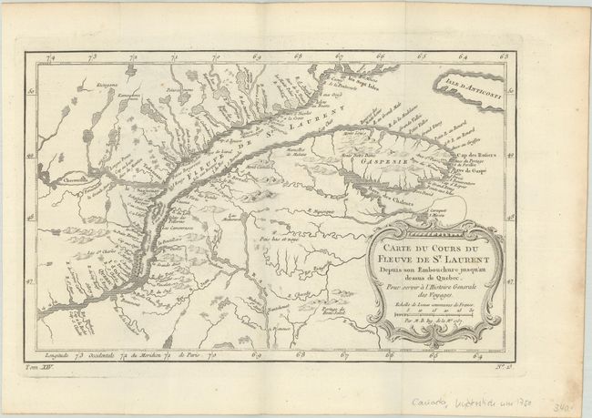
Auction 180, Lot 92
Subject: St. Lawrence River, Canada
Bellin, Jacques Nicolas
[Lot of 2] Carte du Cours du Fleuve de St. Laurent Depuis son Embouchure Jusqu'au Dessus de Quebec. Pour Servir a l'Histoire Generale des Voyages [and] Suite du Cours du Fleuve de St. Laurent Depuis Quebec Jusqu au Lac Ontario..., 1757
Size: 11.8 x 7.4 inches (30 x 18.8 cm)
Estimate: $190 - $220
Sold for: $140
Closed on 11/18/2020
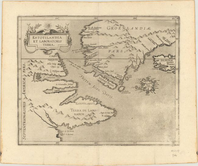
Auction 180, Lot 93
Subject: Eastern Canada & Greenland
Wytfliet, Cornelis
Estotilandia et Laboratoris Terra, 1597
Size: 11.3 x 9.1 inches (28.7 x 23.1 cm)
Estimate: $950 - $1,100
Sold for: $700
Closed on 11/18/2020
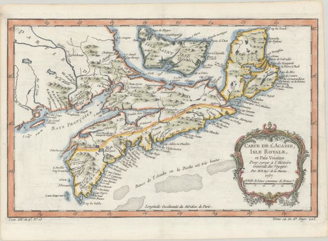
Auction 180, Lot 94
Subject: Eastern Canada
[Lot of 2] Carte de l'Acadie, Isle Royale, et Pais Voisins. Pour Servir a l'Histoire Generale des Voyages [and] Isle et Banc de Terre-Neuve, Isle Royale et Isle St. Jean; avec l'Acadie ou la Nouvelle Ecosse, 1757
Size: See Description
Estimate: $220 - $250
Sold for: $275
Closed on 11/18/2020
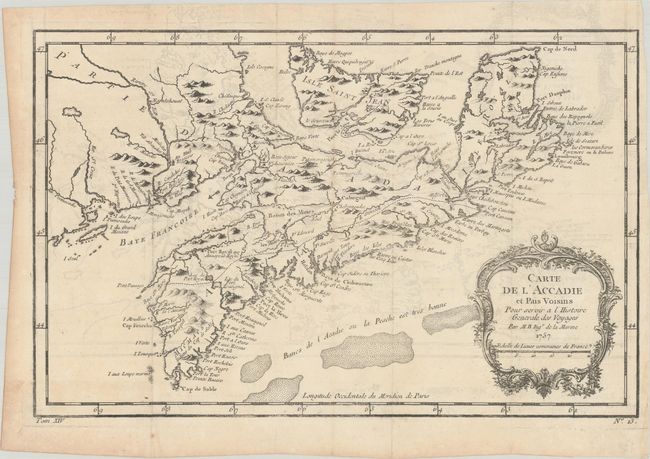
Auction 180, Lot 95
Subject: Eastern Canada
Bellin, Jacques Nicolas
Carte de l'Accadie et Pais Voisins pour Servir a l'Histoire Generale des Voyages, 1757
Size: 13.1 x 8.3 inches (33.3 x 21.1 cm)
Estimate: $100 - $130
Sold for: $75
Closed on 11/18/2020
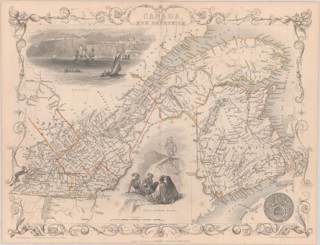
Auction 180, Lot 96
Subject: Eastern Canada
Tallis, John
East Canada, and New Brunswick, 1850
Size: 13.5 x 10.1 inches (34.3 x 25.7 cm)
Estimate: $120 - $150
NO RESERVE
Unsold
Closed on 11/18/2020
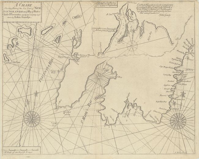
Auction 180, Lot 97
Subject: Newfoundland, Canada
Mount & Page
A Chart Shewing Part of the Sea Coast of New Foundland from ye Bay of Bulls to Little Plecentia Exactly and Carefully Lay'd Down by Iohn Gaudy, 1748
Size: 21.7 x 17.3 inches (55.1 x 43.9 cm)
Estimate: $475 - $600
Sold for: $200
Closed on 11/18/2020
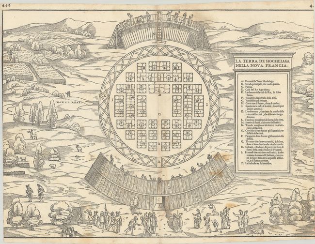
Auction 180, Lot 98
Subject: Montreal, Canada
Gastaldi/Ramusio
La Terra de Hochelaga Nella Nova Francia, 1556
Size: 14.9 x 10.9 inches (37.8 x 27.7 cm)
Estimate: $2,000 - $2,300
Rare First Edition of the First Published Plan of a Settlement in North America
Sold for: $1,500
Closed on 11/18/2020
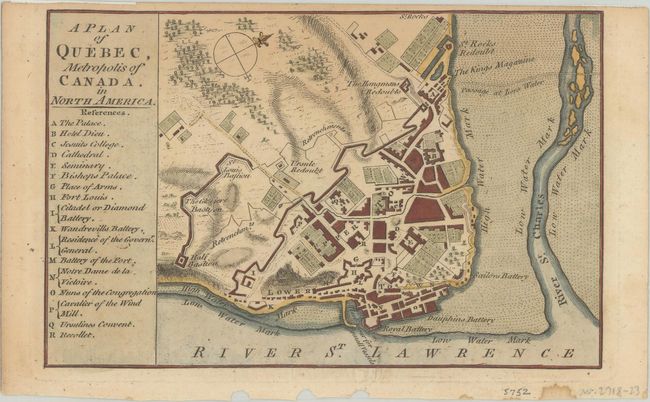
Auction 180, Lot 99
Subject: Quebec City, Canada
Anon.
A Plan of Quebec, Metropolis of Canada. In North America, 1759
Size: 7.1 x 4.6 inches (18 x 11.7 cm)
Estimate: $100 - $130
Sold for: $80
Closed on 11/18/2020
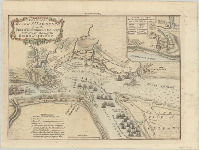
Auction 180, Lot 100
Subject: Quebec City, Canada
A Plan of the River St. Lawrence, from the Falls of Montmorenci to Sillery; with the Operations of the Siege of Quebec, 1759
Size: 9.6 x 6.9 inches (24.4 x 17.5 cm)
Estimate: $140 - $170
Sold for: $600
Closed on 11/18/2020
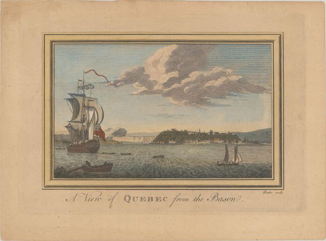
Auction 180, Lot 101
Subject: Quebec City, Canada
A View of Quebec from the Bason, 1760
Size: 8.7 x 5.6 inches (22.1 x 14.2 cm)
Estimate: $160 - $190
Sold for: $80
Closed on 11/18/2020
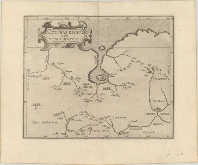
Auction 180, Lot 102
Subject: Central Canada
Wytfliet, Cornelis
Conibas Regio cum Vicinis Gentibus, 1597
Size: 10.6 x 8.6 inches (26.9 x 21.8 cm)
Estimate: $1,000 - $1,300
The Earliest Map of Central Canada and Montreal
Sold for: $1,600
Closed on 11/18/2020
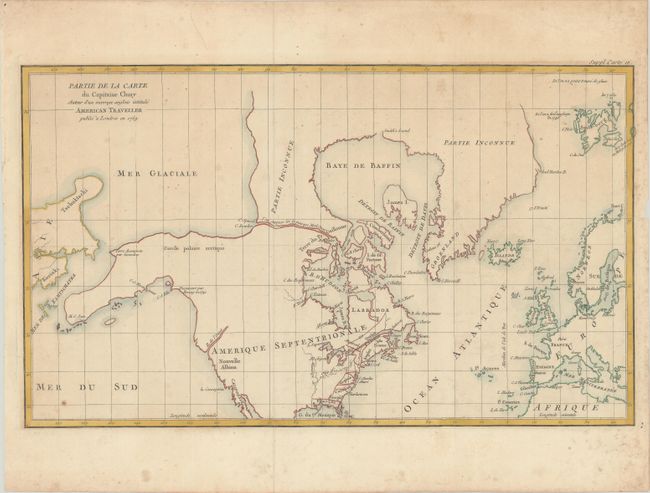
Auction 180, Lot 103
Subject: Colonial United States & Canada, Arctic
Robert de Vaugondy, Didier
Partie de la Carte du Capitaine Cluny Auteur d'un Ouvrage Anglois Intitule American Traveller Publie a Londres en 1769, 1773
Size: 19.4 x 11.5 inches (49.3 x 29.2 cm)
Estimate: $140 - $170
Sold for: $100
Closed on 11/18/2020
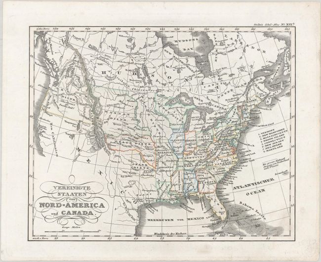
Auction 180, Lot 104
Subject: United States & Canada
Stieler, Adolph
Vereinigte Staaten von Nord-America und Canada, 1840
Size: 9.4 x 7.5 inches (23.9 x 19.1 cm)
Estimate: $150 - $180
Sold for: $110
Closed on 11/18/2020
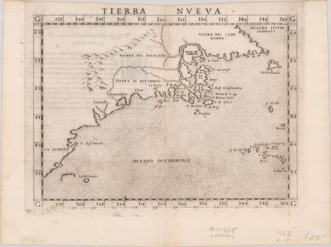
Auction 180, Lot 105
Subject: Eastern United States & Canada
Ruscelli, Girolamo
Tierra Nueva, 1562
Size: 9.6 x 7.1 inches (24.4 x 18 cm)
Estimate: $1,200 - $1,500
First State of Ruscelli's Map of the East Coast
Sold for: $850
Closed on 11/18/2020
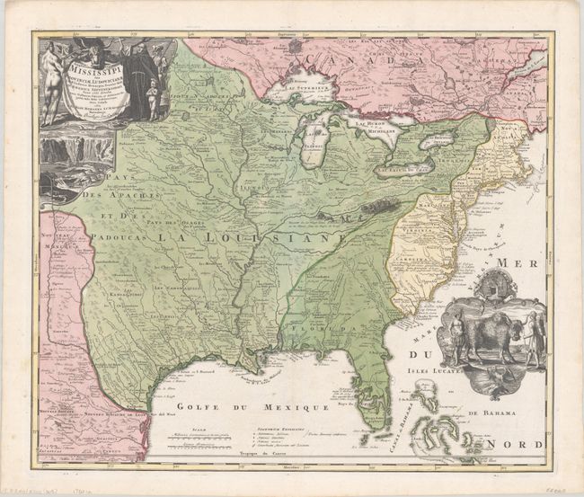
Auction 180, Lot 106
Subject: Colonial Eastern United States & Canada
Homann, Johann Baptist
Amplissimae Regionis Mississipi seu Provinciae Ludovicianae a R.P. Ludovico Hennepin Francisc Miss in America Septentrionali Anno 1687..., 1720
Size: 22.6 x 19.1 inches (57.4 x 48.5 cm)
Estimate: $2,200 - $2,500
Striking Map of Colonial America with Buffalo Vignette
Sold for: $2,750
Closed on 11/18/2020
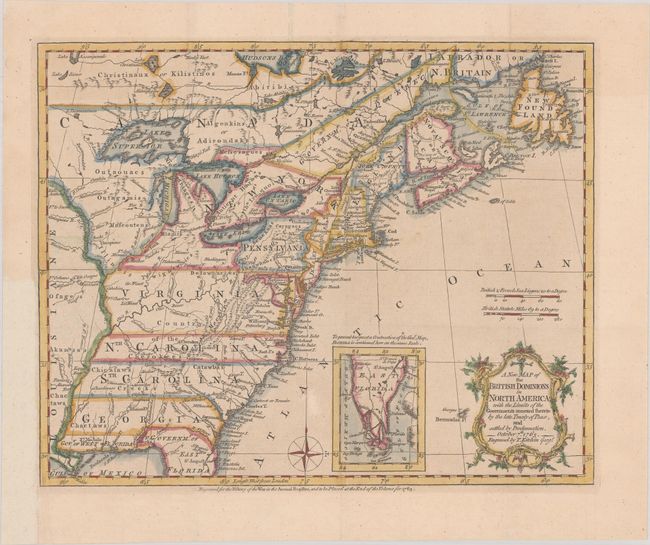
Auction 180, Lot 107
Subject: Colonial Eastern United States & Canada
Kitchin, Thomas
A New Map of the British Dominions in North America; with the Limits of the Governments Annexed Thereto by the Late Treaty of Peace, and Settled by Proclamation, October 7th, 1763, 1763
Size: 11.9 x 9.6 inches (30.2 x 24.4 cm)
Estimate: $475 - $600
Sold for: $500
Closed on 11/18/2020
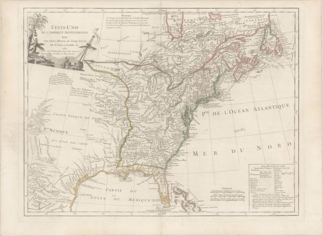
Auction 180, Lot 108
Subject: Eastern United States & Canada
Delamarche, Charles Francois
Etats-Unis de l'Amerique Septentrionale avec les Isles Royale, de Terre Neuve, de St. Jean, l'Acadie &c., 1785
Size: 24.6 x 18.6 inches (62.5 x 47.2 cm)
Estimate: $950 - $1,200
First Reference to Michigan as a Land Division of the United States
Sold for: $700
Closed on 11/18/2020
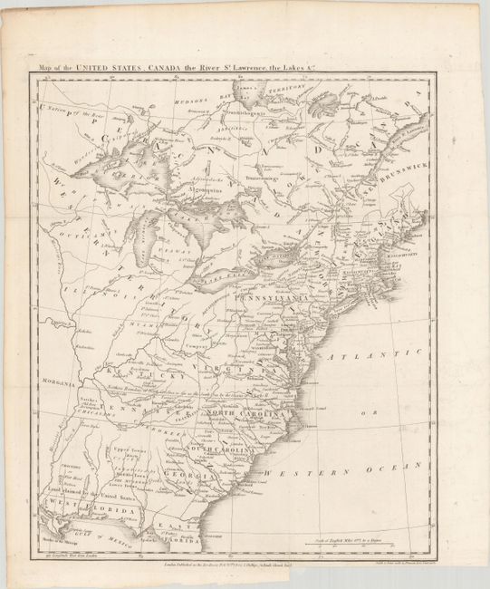
Auction 180, Lot 109
Subject: Eastern United States & Canada, Franklin
Phillips, Richard (Sir)
Map of the United States, Canada the River St. Lawrence, the Lakes &c., 1801
Size: 13.4 x 16 inches (34 x 40.6 cm)
Estimate: $1,400 - $1,700
Features the Short-Lived Franklinia and Morgania
Sold for: $1,000
Closed on 11/18/2020
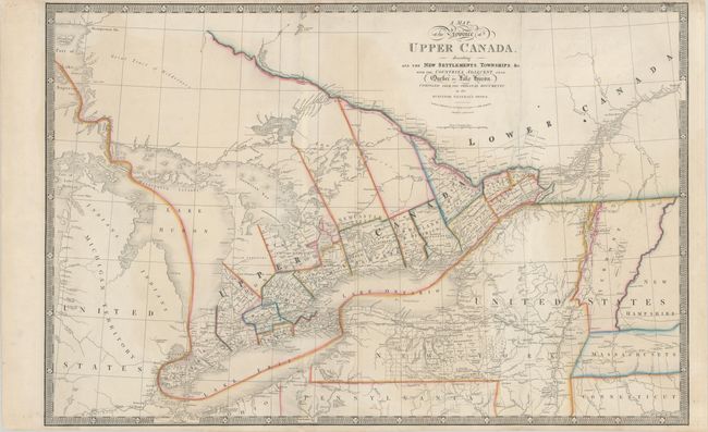
Auction 180, Lot 110
Subject: Eastern United States & Canada
Wyld, James
A Map of the Province of Upper Canada, Describing All the New Settlements, Townships, &c. with the Countries Adjacent, from Quebec to Lake Huron..., 1850
Size: 34.3 x 22.5 inches (87.1 x 57.2 cm)
Estimate: $325 - $400
Sold for: $325
Closed on 11/18/2020
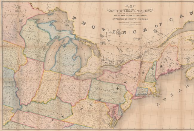
Auction 180, Lot 111
Subject: Eastern United States & Canada
Andrews, Israel D.
Map of the Basin of the St. Lawrence Showing Also the Natural and Artificial Routes Between the Atlantic Ocean and Interior of North America, 1853
Size: 76.8 x 34.4 inches (195.1 x 87.4 cm)
Estimate: $240 - $300
Sold for: $150
Closed on 11/18/2020
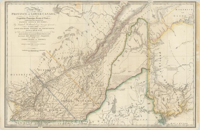
Auction 180, Lot 112
Subject: Maine & Eastern Canada
Wyld, James
A New Map of the Province of Lower Canada, Describing All the Seigneuries, Townships, Grants of Land, &c. Compiled from Plans Deposited in the Patent Office Quebec; by Samuel Holland, Esq. Surveyor General…, 1838
Size: 34.2 x 22.7 inches (86.9 x 57.7 cm)
Estimate: $475 - $600
Unsold
Closed on 11/18/2020
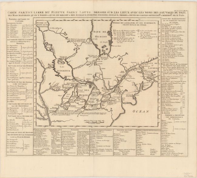
Auction 180, Lot 113
Subject: Colonial Northeastern United States & Canada, Great Lakes
Chatelain, Henry Abraham
Carte Particuliere du Fleuve Saint Louis Dressee sur les Lieux avec les Noms des Sauvages du Pais..., 1720
Size: 17.8 x 14.4 inches (45.2 x 36.6 cm)
Estimate: $600 - $750
Sold for: $550
Closed on 11/18/2020
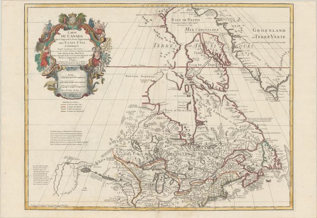
Auction 180, Lot 115
Subject: Colonial Northeastern United States & Canada, Great Lakes
Delisle/Dezauche
Carte du Canada qui Comprend la Partie Septentrionale des Etats Unis d'Amerique Dressee sur Plusieurs Observations et sur un Grand Nombre de Relations Imprimees ou Manuscrites..., 1783
Size: 25.6 x 19.8 inches (65 x 50.3 cm)
Estimate: $700 - $850
Sold for: $400
Closed on 11/18/2020
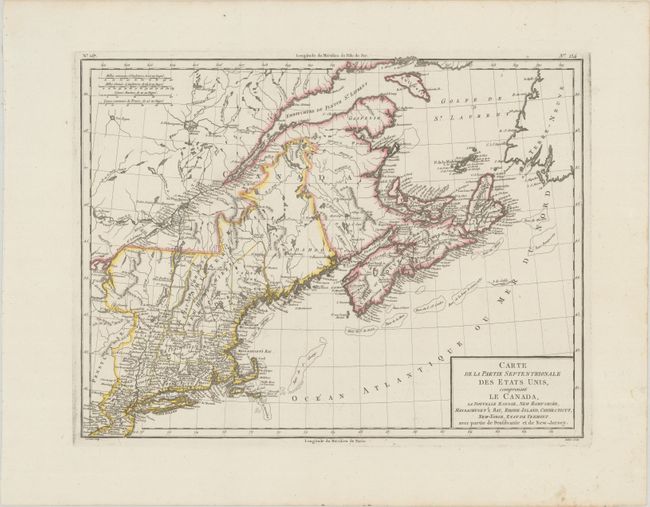
Auction 180, Lot 116
Subject: Northeastern United States & Canada
Tardieu
Carte de la Partie Septentrionale des Etats-Unis, Comprenant le Canada, la Nouvelle Ecosse, New Hampshire, Massachuset's Bay, Rhode-Island, Connecticut, New-Yorck, Etat de Vermont..., 1798
Size: 16.8 x 12.8 inches (42.7 x 32.5 cm)
Estimate: $160 - $190
Sold for: $120
Closed on 11/18/2020
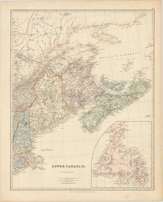
Auction 180, Lot 117
Subject: Northeastern United States & Canada
Arrowsmith, John
Lower Canada &c., 1834
Size: 19 x 23.6 inches (48.3 x 59.9 cm)
Estimate: $200 - $230
Sold for: $100
Closed on 11/18/2020
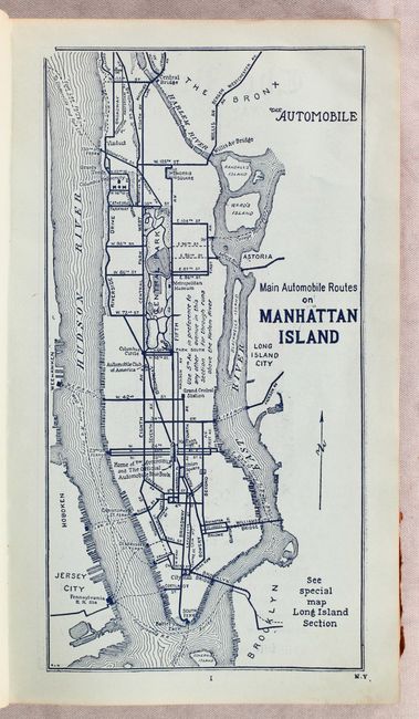
Auction 180, Lot 118
Subject: Northeastern United States & Canada
American Automobile Assoc.
[Lot of 2] The Automobile Official AAA 1906 Blue Book... [and] The Automobile Official AAA 1907 Blue Book..., 1906-07
Size: 5.5 x 9.5 inches (14 x 24.1 cm)
Estimate: $200 - $250
Earliest AAA Automobile Blue Books
Sold for: $200
Closed on 11/18/2020
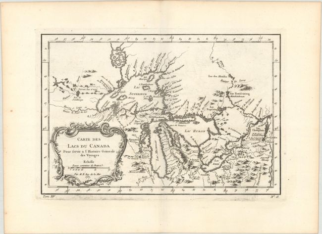
Auction 180, Lot 119
Subject: Colonial Central United States & Canada, Great Lakes
Bellin, Jacques Nicolas
Carte des Lacs du Canada pour Servir a l'Histoire Generale des Voyages, 1757
Size: 11.4 x 7.6 inches (29 x 19.3 cm)
Estimate: $350 - $425
Sold for: $250
Closed on 11/18/2020
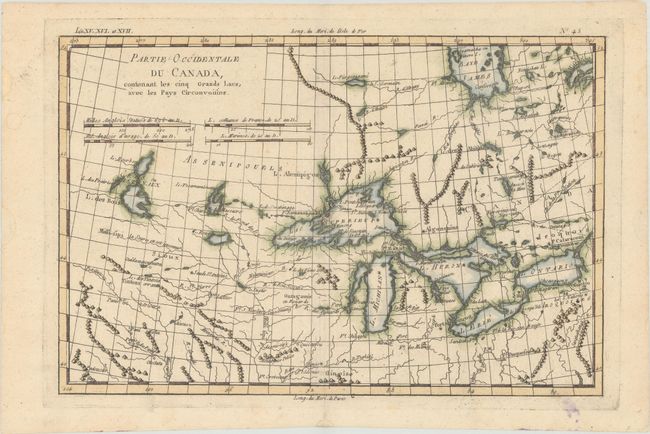
Auction 180, Lot 120
Subject: Colonial Great Lakes
Bonne, Rigobert
Partie Occidentale du Canada, Contenant les Cinq Grands Lacs, avec les Pays Circonvoisins, 1790
Size: 12.5 x 8.3 inches (31.8 x 21.1 cm)
Estimate: $200 - $230
Sold for: $190
Closed on 11/18/2020
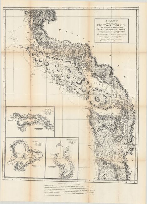
Auction 180, Lot 121
Subject: Northwestern United States & Canada
Vancouver, George (Capt)
A Chart Shewing Part of the Coast of N.W. America, with the Tracks of His Majesty’s Sloop Discovery and Armed Tender Chatham..., 1872
Size: 21.8 x 27.9 inches (55.4 x 70.9 cm)
Estimate: $160 - $190
Sold for: $130
Closed on 11/18/2020
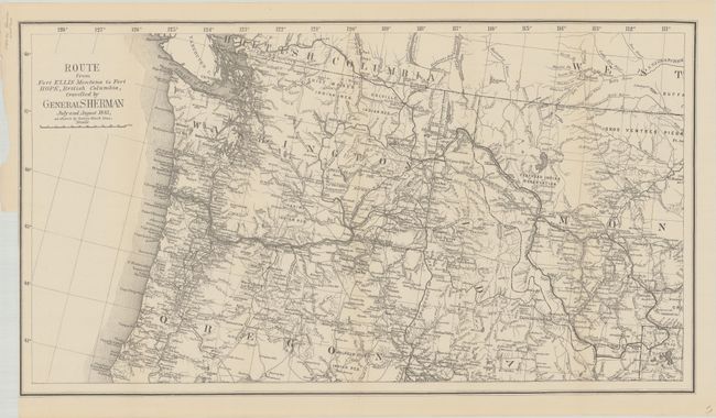
Auction 180, Lot 122
Subject: Northwestern United States & British Columbia
U.S. Government
Route from Fort Ellis Montana to Fort Hope, British Columbia, Travelled by General Sherman July and August 1883, as Shown by Heavy Black Line, 1883
Size: 27.4 x 15.2 inches (69.6 x 38.6 cm)
Estimate: $300 - $375
Sold for: $150
Closed on 11/18/2020
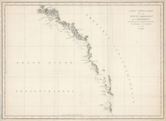
Auction 180, Lot 123
Subject: Western Canada & Alaska
La Perouse, Comte Jean F. Galoup, de
Carte Particuliere de la Cote du Nord-Ouest de l'Amerique Reconnue par les Fregates Francaises la Boussole et l'Astrolabe en 1786. 1e. Feuille, 1797
Size: 27.3 x 19.6 inches (69.3 x 49.8 cm)
Estimate: $180 - $210
Unsold
Closed on 11/18/2020
31 lots