Filtered by Category:Canada(Show All Categories)
Showing results for:Auction 155
Catalog Archive
31 lots
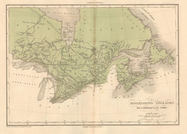
Auction 155, Lot 99
Subject: Canada
Buchon, Jean Alexandre
Carte Geographique, Statistique et Historique des Possessions Anglaises, 1825
Size: 13.9 x 9.8 inches (35.3 x 24.9 cm)
Estimate: $160 - $190
Unsold
Closed on 11/18/2015
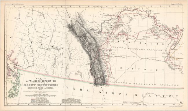
Auction 155, Lot 100
Subject: Canada
Petermann, Augustus Herman
[Lot of 2] Karte von J. Palliser's Expedition zur Erforschung der Rocky Mountains in Britisch-Nord-Amerika, 1858. [and] Karte der Red River Expedition in Britisch Nord-Amerika unter Gladman, Hind, Napier, Dawson, &c. 1857 und 1858., 1860
Size: 17.5 x 9.5 inches (44.5 x 24.1 cm)
Estimate: $240 - $300
Sold for: $150
Closed on 11/18/2015
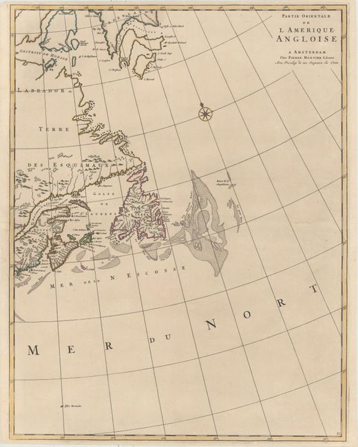
Auction 155, Lot 101
Subject: Eastern Canada
Mortier, Pierre
Partie Orientale de l Amerique Angloise, 1700
Size: 18.4 x 23.8 inches (46.7 x 60.5 cm)
Estimate: $700 - $850
Unsold
Closed on 11/18/2015
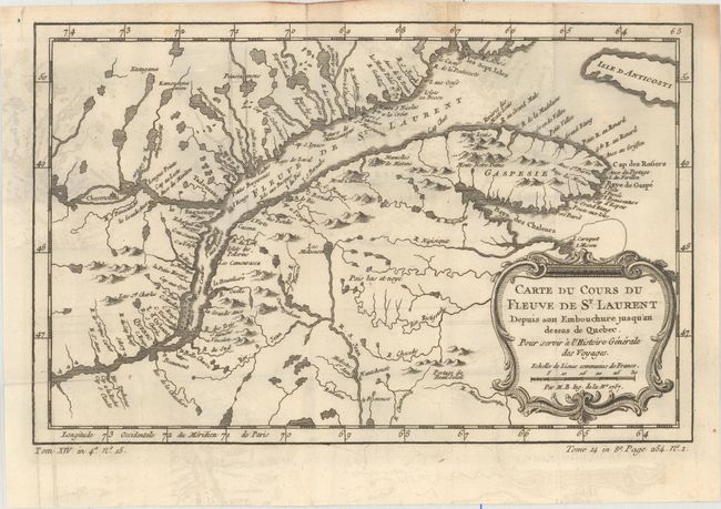
Auction 155, Lot 102
Subject: Eastern Canada, St. Lawrence River
Bellin, Jacques Nicolas
[Lot of 3] Carte du Cours du Fleuve de St. Laurent Depuis son Embouchure Jusqu'au Dessus de Quebec... [and] Suite du Cours du Fleuve de St. Laurent, Depuis Quebec Jusqu au Lac Ontario... [and] Carte du Golphe de St. Laurent et Pays Voisins..., 1780
Size: See Description
Estimate: $250 - $325
Sold for: $60
Closed on 11/18/2015
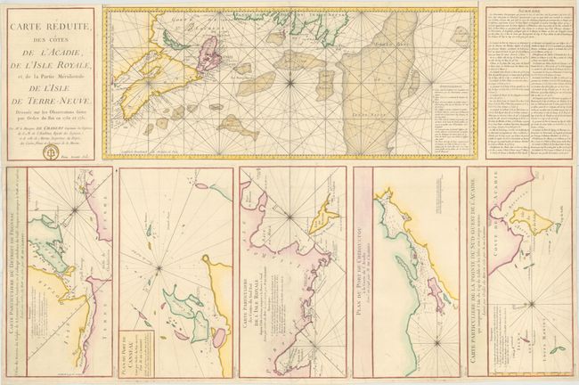
Auction 155, Lot 103
Subject: Eastern Canada
Chabert de Cogolin, Joseph Bernard Marquis de
Carte Reduite des Cotes de l'Acadie, de l'Isle Royale, et de la Partie Meridionale de l'Isle de Terre-Neuve..., 1784
Size: 34 x 22.4 inches (86.4 x 56.9 cm)
Estimate: $400 - $500
Unsold
Closed on 11/18/2015
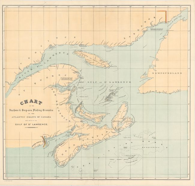
Auction 155, Lot 104
Subject: Eastern Canada
[Lot of 2] Chart of the Inshore & Deep-Sea Fishing Grounds on the Atlantic Coasts of Canada and Within the Gulf of St. Lawrence [and] Newfoundland, 1878
Size: See Description
Estimate: $130 - $160
Unsold
Closed on 11/18/2015
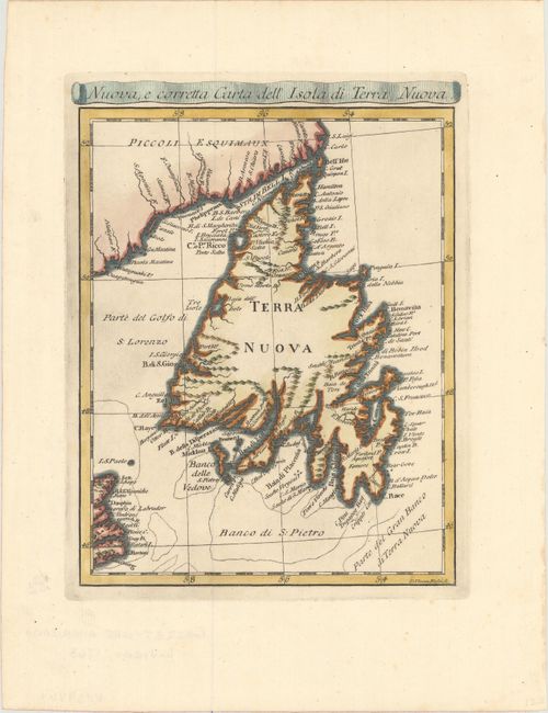
Auction 155, Lot 105
Subject: Newfoundland, Canada
Rossi, Veremondo
Nuova, e Corretta Carta dell' Isola di Terra Nuova, 1763
Size: 6.5 x 8.7 inches (16.5 x 22.1 cm)
Estimate: $220 - $250
Unsold
Closed on 11/18/2015
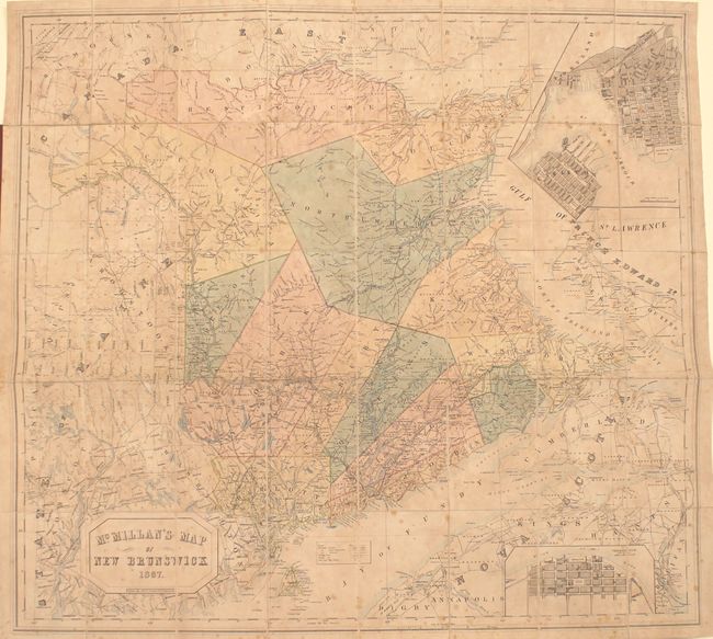
Auction 155, Lot 106
Subject: New Brunswick, Canada
Philip, George
McMillan's Map of New Brunswick, 1867
Size: 38.1 x 35.1 inches (96.8 x 89.2 cm)
Estimate: $400 - $500
Unsold
Closed on 11/18/2015
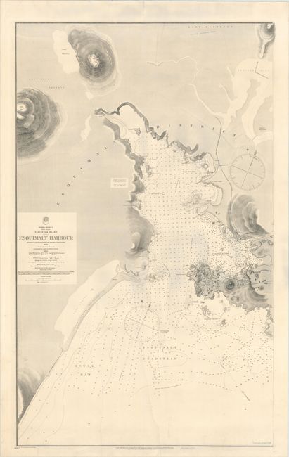
Auction 155, Lot 107
Subject: Vancouver Island, Canada
British Admiralty
North America West Coast Vancouver Island Esquimalt Harbour Surveyed by Captn. G.H. Richards & the Officers of H.M.S. Plumper..., 1897
Size: 24.9 x 40.3 inches (63.2 x 102.4 cm)
Estimate: $400 - $500
Unsold
Closed on 11/18/2015
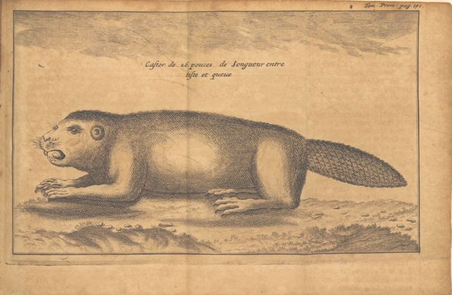
Auction 155, Lot 108
Subject: Colonial Canada & United States, Exploration, River Longue
Lahontan, Louis Armand, Baron de
Nouveaux Voyages de Mr. le Baron de Lahontan, dans l'Amerique Septentrionale, qui Contiennent une Relation des Differens Peuples...[together with] Memoires de l'Amerique Septentrionale..., 1703
Size: 3.7 x 6.3 inches (9.4 x 16 cm)
Estimate: $1,400 - $1,700
Includes the First Edition of Lahontan's Influential Map Depicting "Riviere Longue"
Sold for: $850
Closed on 11/18/2015
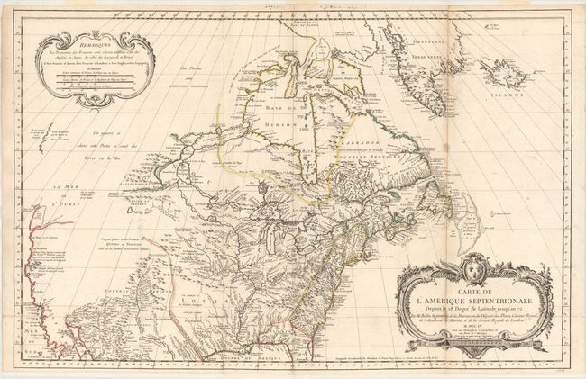
Auction 155, Lot 109
Subject: Colonial United States & Canada
Bellin, Jacques Nicolas
Carte de l'Amerique Septentrionale Depuis le 28 Degre de Latitude Jusqu'au 72, 1755
Size: 34 x 22 inches (86.4 x 55.9 cm)
Estimate: $1,500 - $1,800
NO RESERVE - Bellin's Important, Large Format Map of North America
Unsold
Closed on 11/18/2015
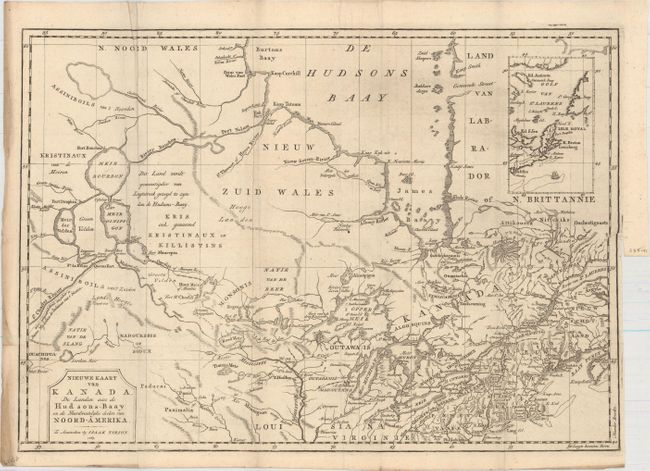
Auction 155, Lot 110
Subject: Colonial United States & Canada
Tirion, Isaac
Nieuwe Kaart van Kanada, de Landen aan de Hudsons-Baay en de Noordwestelyke deelen van Noord-Amerika, 1769
Size: 16.8 x 12 inches (42.7 x 30.5 cm)
Estimate: $275 - $350
Sold for: $160
Closed on 11/18/2015
Auction 155, Lot 111
Subject: Canada & United States
Arrowsmith & Lewis
[Lot of 2] United States [and] British Possessions in America, 1804
Size: 9.8 x 7.9 inches (24.9 x 20.1 cm)
Estimate: $250 - $325
Unsold
Closed on 11/18/2015
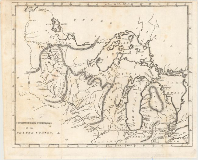
Auction 155, Lot 112
Subject: Canada & United States
Brookes, Richard
[Lot of 3] The Northwestern Territories of the United States [and] The Middle States and Western Territories of the United States Including the Seat of the Western War [and] The Eastern States with Part of Canada, 1812
Size: 9.6 x 7.8 inches (24.4 x 19.8 cm)
Estimate: $400 - $500
Sold for: $250
Closed on 11/18/2015
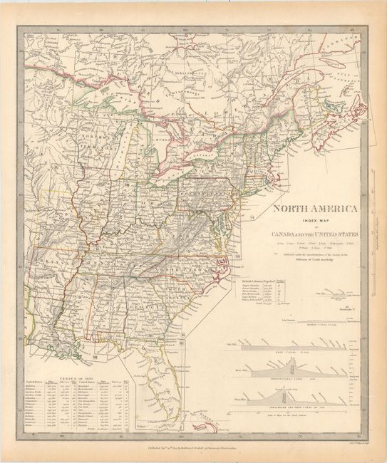
Auction 155, Lot 113
Subject: Canada & United States
SDUK Society for the Diffusion of Useful Knowledge
[Lot of 15 - North America], 1832-34
Size: See Description
Estimate: $1,300 - $1,600
Matching Set of North America SDUK Maps
Sold for: $650
Closed on 11/18/2015
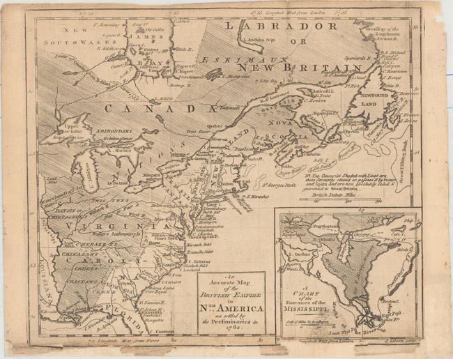
Auction 155, Lot 114
Subject: Colonial Eastern United States & Canada
Gibson, John
An Accurate Map of the British Empire in Nth. America as Settled by the Preliminaries in 1762, 1762
Size: 9.7 x 8.3 inches (24.6 x 21.1 cm)
Estimate: $200 - $250
Unsold
Closed on 11/18/2015
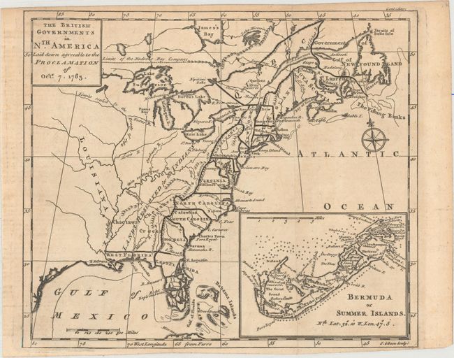
Auction 155, Lot 115
Subject: Colonial Eastern United States & Canada
Gibson, John
The British Governments in Nth. America Laid Down Agreeable to the Proclamation of Octr. 7. 1763, 1763
Size: 9.2 x 8 inches (23.4 x 20.3 cm)
Estimate: $350 - $450
Sold for: $250
Closed on 11/18/2015
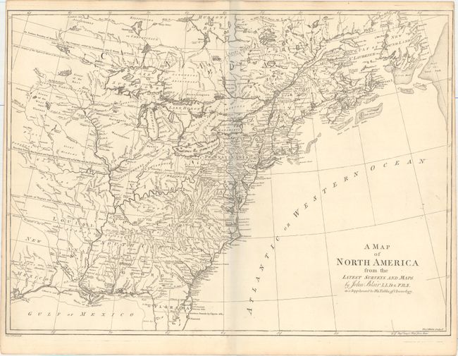
Auction 155, Lot 116
Subject: Colonial Eastern United States & Canada
Blair, Rev. John
A Map of North America from the Latest Surveys and Maps, 1768
Size: 22 x 16 inches (55.9 x 40.6 cm)
Estimate: $900 - $1,100
Sold for: $500
Closed on 11/18/2015
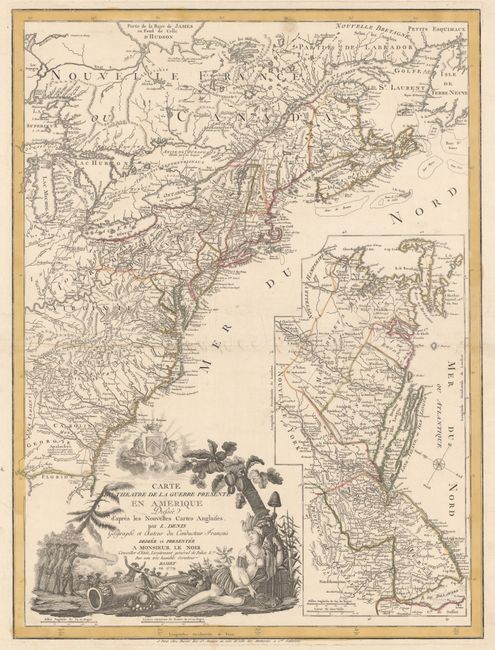
Auction 155, Lot 117
Subject: Colonial Eastern United States & Canada
Denis, Louis
Carte du Theatre de la Guerre Presente en Amerique Dressee d'Apres les Nouvelles Cartes Anglaises..., 1779
Size: 19.8 x 26.3 inches (50.3 x 66.8 cm)
Estimate: $5,500 - $6,500
Scarce American Revolutionary War Map
Unsold
Closed on 11/18/2015
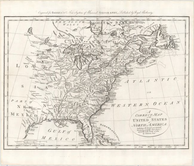
Auction 155, Lot 118
Subject: Eastern United States & Canada
Bowen, Thomas
A Correct Map of the United States of North America. Including the British and Spanish Territories, Carefully Laid Down Agreeable to the Treaty of 1784, 1787
Size: 17.6 x 12.4 inches (44.7 x 31.5 cm)
Estimate: $350 - $450
Sold for: $250
Closed on 11/18/2015
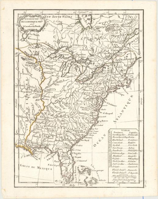
Auction 155, Lot 119
Subject: Eastern United States & Canada
Delamarche, Charles Francois
Etats-Unis de l'Amerique Seple. avec le Canada et la Floride, 1800
Size: 7.3 x 9.9 inches (18.5 x 25.1 cm)
Estimate: $275 - $350
Sold for: $150
Closed on 11/18/2015
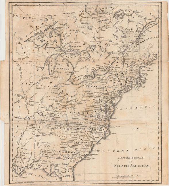
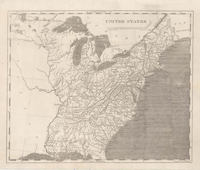
Auction 155, Lot 120
Subject: Eastern United States & Canada
Phillips, Richard (Sir)
United States in North America, 1809
Size: 13.3 x 15.8 inches (33.8 x 40.1 cm)
Estimate: $500 - $650
Unique Map Depicting Both Franklinia and Morgania
Sold for: $1,600
Closed on 11/18/2015
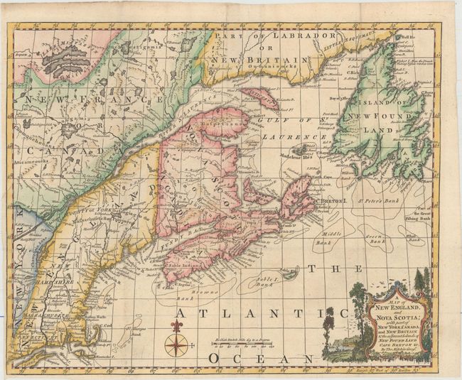
Auction 155, Lot 121
Subject: Colonial Northeastern United States & Canada
Kitchin, Thomas
A Map of New England, and Nova Scotia; with Part of New York, Canada, and New Britain & the Adjacent Islands of New Found Land Cape Breton &c., 1758
Size: 13 x 10.6 inches (33 x 26.9 cm)
Estimate: $250 - $325
Sold for: $180
Closed on 11/18/2015
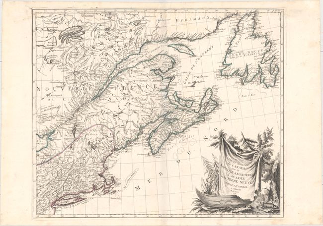
Auction 155, Lot 122
Subject: Colonial Northeastern United States & Canada
D'Anville/Santini
Partie Orientale du Canada, avec la Nouvelle Angleterre, l'Acadie, et la Terre-Neuve..., 1776
Size: 22.9 x 19.3 inches (58.2 x 49 cm)
Estimate: $750 - $900
Sold for: $275
Closed on 11/18/2015
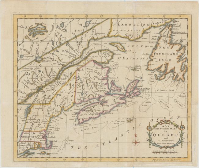
Auction 155, Lot 123
Subject: Colonial Northeastern United States & Canada
Anon.
A New and Accurate Map of Quebec and Its Boundaries; from a Late Survey, 1781
Size: 12.8 x 10.6 inches (32.5 x 26.9 cm)
Estimate: $200 - $230
Sold for: $150
Closed on 11/18/2015
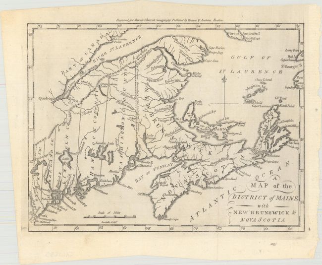
Auction 155, Lot 124
Subject: Northeastern United States & Canada
Morse, Jedidiah (Rev.)
A Map of the District of Maine with New Brunswick & Nova Scotia, 1796
Size: 9.1 x 6.9 inches (23.1 x 17.5 cm)
Estimate: $120 - $160
Unsold
Closed on 11/18/2015
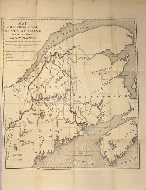
Auction 155, Lot 125
Subject: Northeastern United States & Canada
[Lot of 3] Map of the Northern Part of the State of Maine and the Adjacent British Provinces... [and] Extract from a Map of the British and French Dominions in North America [and] Part of the United States, Lower Canada & New Brunswick, 1838-40
Size: See Description
Estimate: $300 - $375
Unsold
Closed on 11/18/2015
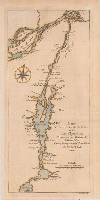
Auction 155, Lot 126
Subject: New York, Vermont, and Southern Quebec
Bellin, Jacques Nicolas
Carte de la Riviere de Richelieu et du Lac Champlain, Dressee sur les Manuscrits du Depost des Cartes, Plans, et Journx. de la Marine, 1744
Size: 5.4 x 11.9 inches (13.7 x 30.2 cm)
Estimate: $200 - $240
Sold for: $180
Closed on 11/18/2015
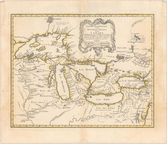
Auction 155, Lot 127
Subject: Colonial Great Lakes
Bellin/Homann Heirs
Partie Occidentale de la Nouvelle France ou du Canada, 1755
Size: 21.3 x 16.8 inches (54.1 x 42.7 cm)
Estimate: $1,400 - $1,700
Influential Map of the Great Lakes
Sold for: $1,500
Closed on 11/18/2015
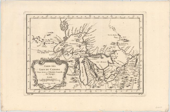
Auction 155, Lot 128
Subject: Colonial Great Lakes
Bellin, Jacques Nicolas
Carte des Lacs du Canada pour Servir a l'Histoire Generale des Voyages, 1757
Size: 11.5 x 7.8 inches (29.2 x 19.8 cm)
Estimate: $400 - $500
Sold for: $350
Closed on 11/18/2015
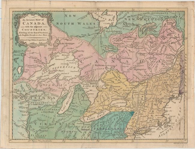
Auction 155, Lot 129
Subject: Colonial Great Lakes
[Lot of 2] An Accurate Map of Canada, with the Adjacent Countries; Exhibiting the Late Seat of War Between the English & French in These Parts [and] An Accurate Map of the Present Seat of War, Between Great-Britain and Her Colonies in North America, 1761-76
Size: 13.6 x 10.3 inches (34.5 x 26.2 cm)
Estimate: $400 - $500
Sold for: $300
Closed on 11/18/2015
31 lots