This portrait of Hernán Cortés and Mexico City, the city he built atop the Aztec capital of Tenochtitlán, comes from the title page of Antonio de Herrera y Tordesillas’s Historia General de los Hechos de los Castellanos en las Islas i Tierra Firme del Mar Oceano (1601). (Image courtesy of Old World Auctions - click on image to view zoomable image.)
Mapping Cortés
by Joe McAlhany
The most notorious and consequential of the 16th-century conquistadors, Hernán Cortés is an explorer known as much today for what he destroyed as for what he discovered. His toppling of the mighty Aztec Empire opened the New World up to further Spanish exploration and control. From the ashes of the Aztec capital of Tenochtitlán he established Mexico City, the hub of colonial power in New Spain and now the largest city in North America. Later, he backed the expeditions that discovered Baja California and the Gulf of California, which was named the Sea of Cortés in his honor. A larger-than-life figure with a complicated legacy, Cortés made his mark on the New World and on the maps that followed in the wake of his expeditions. Here we will tell the story of the fierce conquistador, with an emphasis on the maps and related engravings that documented and mythologized his exploits.
Hernán Cortés was born in 1485 in the village of Medellín in Extremadura, Spain, to a family with a noble name but little wealth. When he was 14 years old, he relocated to Salamanca to study for a career in law, but he abandoned his courses after a couple of years. Inspired from a young age by the tales of Columbus’ exploits in the Indies, he was restless to pursue adventure and opportunity for himself in the New World. In 1504, Cortés set sail for Santo Domingo, Hispaniola, where Nicolás de Ovando, a distant relative and family friend, served as governor. He spent the next seven years as a colonist in the town of Azua, where he established himself as a notary and a farmer with a vast estate and Taíno slaves.
Accounts of Cortés portray him as a fiercely intelligent, self-made man of lordly bearing, with a cruel streak and a propensity for compulsive gambling and womanizing. His lust for greater wealth and power compelled him to join Diego Velázquez de Cuéllar, a lieutenant to the governor of Hispaniola, on his conquest of Cuba in 1511. Within a few years, Velázquez had dominated and pacified the indigenous peoples of Cuba, and Cortés had made a name for himself in a new Spanish colony. He was given land and slaves in the freshly established capital of Santiago, where he was twice appointed alcalde (chief municipal magistrate).
Upon hearing conquistador Juan de Grijalva’s reports of beauty and riches in Cozumel and the Tabasco region, Cortés hatched his own plan to venture west to Mexico. In October 1518, Velázquez, now the Governor of Cuba, offered Cortés a few ships for his mission as long as he could finance the voyage and serve as the captain-general to the expedition. Cortés was all-too-eager to take on the responsibility – and power, of course – and his ambitions quickly ballooned to such an extent that a panicked Velázquez revoked his charter. (Cortés’s messy romantic entanglement with Velázquez’s sister-in-law may have also been a factor in the governor’s decision.) In flagrant defiance of Velázquez’s orders, Cortés departed for the Yucatán on February 18, 1519, with a fleet of 11 ships, 600 men, and more than a dozen horses.
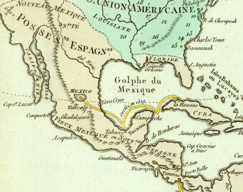
De l’Amerique, Plan de Tableau…, published by Didot in 1807, is one of several maps that highlights Cortés’s route from Cuba to Tenochtitlán. (Image courtesy of Old World Auctions - click on image to view zoomable image.)
Cortés and his men first arrived in Cozumel, where they were awed by the Mayan pyramids and and appalled by the evidence of human sacrifice. The conquistador, determined to convert the Mayas to Christianity, shattered their pagan idols and replaced them with crosses and statues of the Virgin Mary. While on the island, he also rescued Gerónimo de Aguilar, a shipwrecked Franciscan friar who would serve as Cortés’s interpreter among the Mayas.
From Cozumel, the expedition traveled to Tabasco, arriving at the mouth of the Grijalva River on March 12, 1519. They sought the great Mayan city of Potonchán, where Grijalva had received a warm welcome less than a year prior. The Mayas initially offered Cortés some small gifts, but they made it clear that they wanted neither further trade nor conflict and that the Spanish would have to leave. Cortés refused and the Battle of Cintla broke out. The Mayas had never seen horses before and could not hold their own against Spanish guns and crossbows. They had no choice but to surrender to Cortés and pledge their loyalty to Spain. The local chief awarded the victors food, supplies, and 20 slave women, among them a Nahua woman known as Marina, Malintzin, or La Malinche. Fluent in both Chontal Maya and the Aztec language of Nahuatl (she quickly picked up Spanish as well), La Malinche would become a critical member of the expedition, serving not just as Cortés’s interpreter, but also eventually as his guide, advisor, and mistress.
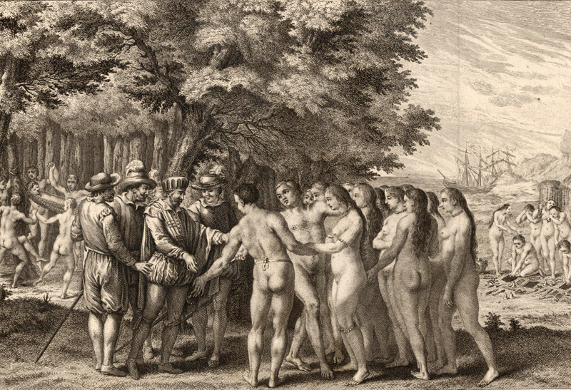
This engraving from a German edition of Jacques Nicolas Bellin’s L’Histoire Generale des Voyages (1755) depicts Cortés and La Malinche meeting for the first time. La Malinche looms large in the Cortés story. (Image courtesy of Old World Auctions - click on image to view zoomable image.)
As Cortés continued to travel west along the Mexican coast, asking everywhere about gold, he gathered more information about an inland kingdom called Mexico, the realm of the Mexica or Aztec people. The Aztecs, under the rule of the tlatoani (emperor) Moctezuma II, controlled a vast territory in Mexico and Central America, having subjugated hundreds of neighboring states throughout the 15th century. On Easter Sunday, 1519, emissaries of Moctezuma met with Cortés near Veracruz. They came bearing impressive gifts of gold and precious stones. The conquistador asked if there was more gold and requested a meeting with the emperor. Moctezuma was wary of meeting with the Spanish and refused. Traditional accounts of the conquest of the Aztecs claim Moctezuma was haunted by the belief that Cortés was the prophesied return of the exiled god Quetzacoatl, but this idea has been debunked by many contemporary scholars as a colonialist fantasy.
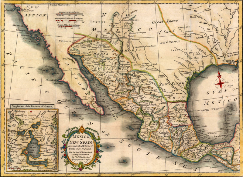
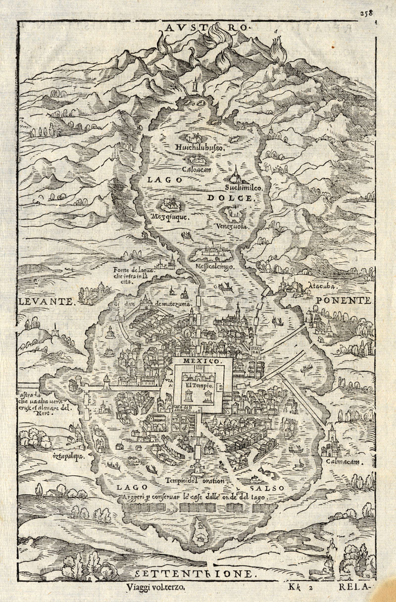
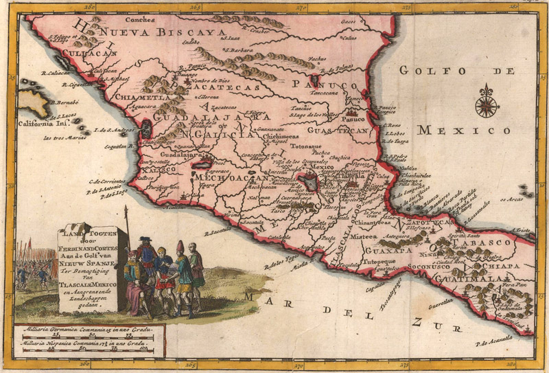
Thomas Kitchin’s Mexico, or New Spain; in Which the Motions of Cortés May Be Traced (circa 1780) does not explicitly map out Cortés’s route, but its title identifies the region with the conquistador centuries after his death. The inset at bottom left zooms in on Mexico City and its vicinity, the heart of New Spain, just as Tenochtitlán was once the heart of the Aztec Empire. (Image courtesy of Old World Auctions - click on image to view zoomable image.)
In July 1519, Cortés founded a base in Veracruz where he began preparations for an inland expedition to Tenochtitlán, capital of the Aztec empire. He officially renounced the authority of Velázquez, who was demanding the conquistador’s return to Cuba, and somewhat dubiously declared himself under the direct command of Charles V. Faced with the prospect of encountering the region’s great empire under a rogue leader, Cortés’s soldiers grew uneasy. He quickly quashed a mutiny attempt and destroyed his own ships to make retreat to Cuba impossible. He convinced his men that their only destiny was to march forward to Tenochtitlán.
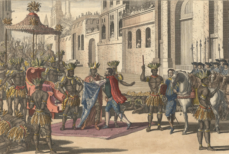
This engraving from John Harris’ Navigantium Atque… (circa 1705) depicts the momentous meeting of Cortés and Moctezuma on November 8, 1519. (Image courtesy of Old World Auctions - click on image to view zoomable image.)
And so, the expedition embarked on the grueling 200-mile journey to the great city, along the way forging alliances with embittered Aztec subjects, such as the Tlaxcalans and Totonacs. In October 1519, Cortés’s army, along with 1,000 Tlaxcalan allies, massacred thousands of unarmed Aztecs in the city of Cholula, based on reports from the Tlaxcalans and La Malinche of an impending Cholulan ambush. After this brutal show of force, on November 8, 1519, Cortés and his small army entered Tenochtitlán. They were completely stunned. The city of 400,000 people was built on Lake Texcoco and connected to the surrounding land by great causeways. At its core was a massive temple complex unlike anything the Spanish had ever seen before. A cautious but friendly Moctezuma greeted Cortés diplomatically at the entrance to the city, draping lavish necklaces of gold and gems around the conquistador’s neck. After Cholula, the Aztecs knew the Spanish could not be trusted – and they were right to be suspicious. Within a week, Cortés put Moctezuma under house arrest and attempted to rule the city through the weakened emperor.
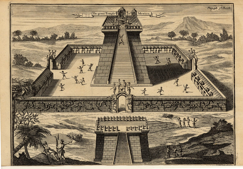
This depiction of the central temple complex in Tenochtitlán was published in the 1723 English translation of Antonio de Solis’s Historia de la Conquista de México. (Image courtesy of Old World Auctions - click on image to view zoomable image.)
In April 1520, Cortés’s puppet reign was sidetracked by trouble with Velázquez, who had dispatched an expedition to arrest the conquistador for overstepping the terms of his charter. Cortés left one of his lieutenants, Pedro de Alvarado, in Tenochtitlán and headed for the coast, where he ambushed the arrest party by night and persuaded the survivors to join him in the capital. When he returned to Tenochtitlán with his expanded army, he found the city in a state of chaos. Alvarado had murdered several elite members of Aztec society during an important religious festival, inciting a violent rebellion among the Aztecs. Cortés ordered Moctezuma to calm the revolt, but the emperor was unsuccessful. Moctezuma was then killed, although accounts vary as to whether it was at the hands of the Spanish or his own people. On the night of July 1, 1520, now known as La Noche Triste, Cortés and his army were attacked as they attempted a stealth escape from Tenochtitlán along one of its causeways. Hundreds of Spaniards and thousands of their indigenous allies were killed in the retreat.
For the next several months, Cortés and his men recuperated in the city of Tlaxcala, successfully securing reinforcements from Cuba and constructing a small fleet of ships for their retaliation on Tenochtitlán. Meanwhile, the indigenous population of the region was devastated by a smallpox epidemic brought on by contact with the Spanish. In May 1521, Cortés and his allied force of more than 800 Spaniards and tens of thousands of indigenous warriors convened on the shores of Lake Texcoco and began a 93-day siege of Tenochtitlán, cutting off incoming supplies while periodically launching attacks on the city. Once the Aztec defenses crumbled, Cortés’s coalition army invaded the city, looting and decimating it block by block. Finally, on August 13, 1521, the Aztecs of Tenochtitlán surrendered to Cortés. Over the ruins of Tenochtitlán Cortés began the construction of Mexico City, soon to be the most important European city in the New World. Charles V appointed Cortés as the governor, captain general, and chief justice of New Spain, although he was closely supervised by royal officials, much to the conquistador’s chagrin.
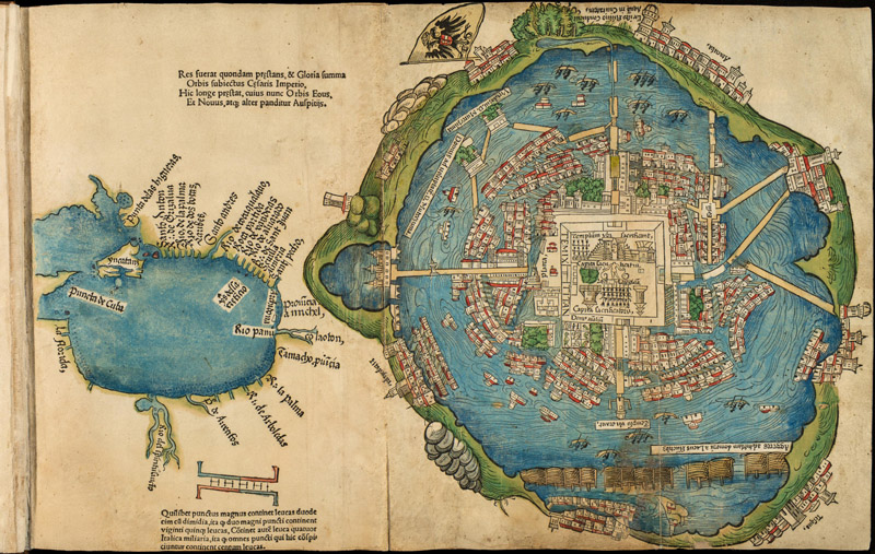
The Cortés map published with his second letter to Charles V (1524). (Image courtesy of The Library of Congress)
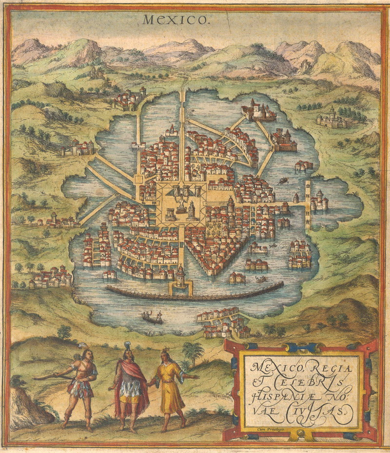
Cortés’s most significant cartographical contribution was the map of the fallen city of Tenochtitlán published with the first Latin edition of his second letter to Charles V. Published in Praeclara Ferdinadi di Cortesii de Nova Maris Oceani… (Nuremberg, 1524), this woodcut engraving features a small map at left of the Gulf of Mexico and a plan view of Tenochtitlán at right. According to Cortés, one of Moctezuma’s artists drew the maps for him, but this is doubtful in the case of the Gulf of Mexico map since it extends well outside the Aztec Empire. It appears most similar to Alvarez de Pineda’s 1519 map of the region, especially with its depiction of the Rio del Spiritu Sancto, an early rendering of either Mobile Bay or the Mississippi River.
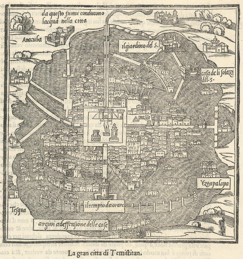
“La Gran Citta di Temistitan” was published in Benedetto Bordone’s Isolario (1534), just ten years after the appearance of the Cortés map. (Image courtesy of Old World Auctions - click on image to view zoomable image.)
“Relatione della Citta del Temistitan,” another derivative of the Cortés map, was published in Ramusio’s Delle Navigazioni et Viaggi (1556). (Image courtesy of Old World Auctions - click on image to view zoomable image.)
The Tenochtitlán plan, however, was likely derived from Aztec sources. (It is hard to say definitively since no Aztec maps of the city survived the conquest.) Even though the plan shows European architectural conventions in the domes and towers of the surrounding cities, its symbolic depiction of the temple precinct is clearly steeped in the specifics of Aztec mythology. This plan was the first rendering of the Aztec capital available to Europeans and the first printed plan of a city in the Americas. It was copied by several European publishers, including Benedetto Bordone in his Isolario (1534); Giovanni Battista Ramusio for his Delle Navigazioni et Viaggi (1556); and Braun and Hogenberg for their Civitates Orbis Terrarum (1572).
Braun and Hogenberg’s view of Tenochtitlan (1572) is derived from the Cortés map. This is one of only two New World city plans in the Civitates Orbis Terrarum. (Image courtesy of Old World Auctions - click on image to view zoomable image.)
Despite the ostensible success of his expedition, Cortés faced constant scandal and political fallout in the aftermath of his conquest of Mexico, much of it engineered by Velázquez. There were rumors that Cortés killed his wife and accusations of corruption and lining his own pockets with money owed to the Spanish Crown. In 1524, Cortés embarked on a failed two-year expedition to Honduras that attracted increased scrutiny from his political rivals. Cortés attempted to justify his actions in a series of five letters to Charles V, but a royally appointed commissioner was shipped in to investigate Cortés. When the commissioner abruptly died of fever soon after arriving in Veracruz, Cortés was suspected of murdering him. A vengeful new governor was appointed to replace Cortés and the conquistador withdrew to his estate.
One of a few Pieter van der Aa maps to depict Cortés’s adventures in New Spain, Land Togten door Ferdinand Cortes aan de Golf van Nieuw Spanje… (1710) shows indigenous people bringing treasure to Cortés in its title cartouche. The map seems to symbolically suggest that they gave the conquistador the land. (Image courtesy of Old World Auctions - click on image to view zoomable image.)
In 1528, Cortés was exiled from Mexico by the new governor and returned to Spain in order to directly appeal to Charles V and put an end to the political attacks that plagued him. He brought along heaps of treasure and convinced the king that he had paid more than his share to the Crown. The king responded by honoring Cortés with the noble title of don and declaring him the Marquess of the Valley of Oaxaca, a hereditary title that awarded Cortés 23,000 vassals in one of the richest regions of New Spain. But despite these victories, Cortés was not restored to his position as a governor.
When he returned to Mexico in 1530, the country was in disarray. From his home base in Cuernavaca, Cortés began building his palace and preparing for explorations along the Pacific coast of Mexico. While he was away in Spain, rival conquistador Nuño de Guzmán had made headway exploring the coast, threatening Cortés’s claim on northern Mexico. Although he was no longer governor, Cortés could still commission expeditions as a captain general, and beginning in 1532, he backed several outings along the western coast of Mexico.
In early 1534, survivors of one of his tumultuous expeditions, captained by the pilot Fortún Ximénez after a mutiny, returned with stories of an alien coast in the northwest, somewhere in the vicinity of present-day Baja California. Based on these reports, Cortés took an expedition directly to the southeastern tip of the Baja Peninsula, where he established a failed colony called Santa Cruz near present-day La Paz. At the time, the men might have assumed this colony was on an offshore island; in actuality, they had just initiated the colonization of California.
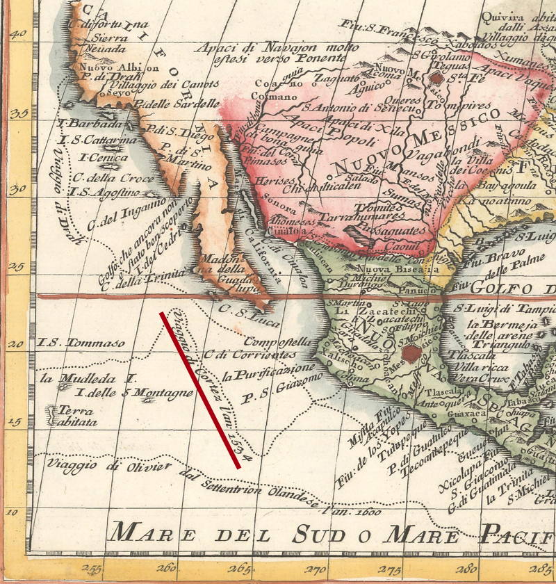
Girolami Albrizzi’s Carta Geografica dell' America Settentrionale (circa 1750) refers to a “Viaggio di Cortez l’an 1534” in the Pacific (underlined in red), departing from Colima and venturing out into the Pacific. While Cortés was financing expeditions along Mexico’s Pacific coast at that time, it is not clear what expedition the map is referencing. (Image courtesy of Old World Auctions - click on image to view zoomable image.)
The colony was abandoned in 1536, but the accounts of strange lands and riches from Álvar Núñez Cabeza de Vaca and the other survivors of the Narváez expedition in the present-day American Southwest and northern Mexico inspired Cortés to finance another venture along the coast. He put his trusted lieutenant Francisco de Ulloa in charge. On July 8th, 1539, Ulloa set sail from Acapulco with three small ships, likely under orders to travel as far up the coast as he could, with an eye out for a northern passage to Asia. Over the course of the next three months, Ulloa would successfully circumnavigate what we now know as the Gulf of California. He claimed the land he saw for the Spanish Crown and named the gulf after his patron, calling it the Sea of Cortés. Although the cartographic myth of the island of California continued beyond this discovery, Ulloa’s findings were among the first to confirm that California was indeed a peninsula.
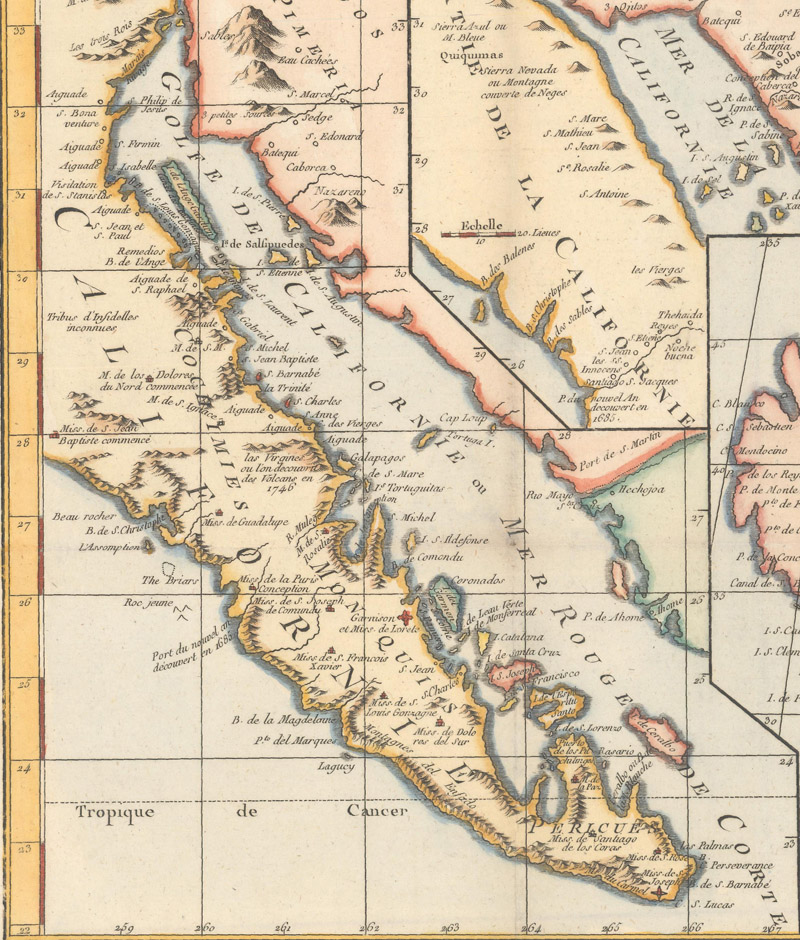
Didier Robert de Vaugondy’s Carte de la Californie… (circa 1772) labels the Gulf of California as “Mer Rouge de Corte.” (Image courtesy of Old World Auctions - click on image to view zoomable image.)
Backing the Ulloa expedition was the last notable success of Cortés’s life. He returned to Spain in 1541. Dogged by debt and an endless stream of lawsuits against him, he died from pleurisy in Seville on December 2, 1547. He had been preparing for a return to Mexico, the land he had conquered more than a quarter of a century before.
To say that Cortés’s legacy is complicated would be an understatement. Even in his own time, authors like the Dominican friar Bartolomé de Las Casas accused him of excessive brutality towards the indigenous peoples of Mexico. He may have founded Mexico City, Mexico’s present-day capital and one of the world’s great metropolises, but in order to do so he destroyed an entire civilization. With this apocalyptic conquest, he cleared the way for Spanish control of the region, and with his further exploits he helped to extend their domain north into California.
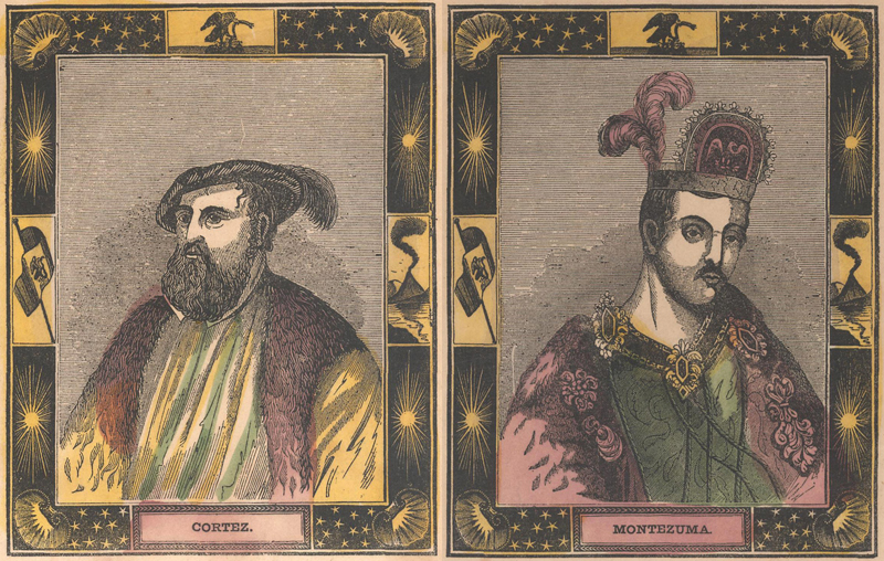
This later portrait of Cortés appears along with a portrait of Moctezuma on Humphrey Phelps’ Ornamental Map of the United States & Mexico (1847). It is interesting that the map presents both the conquistador and the vanquished Aztec emperor as the dual symbols of Mexico. (Image courtesy of Old World Auctions - click on image to view zoomable image.)
There are few first-hand European accounts of the conquest of Mexico. Although Cortés himself wrote an account in his five letters to Charles V, they must be read with several grains of salt since they are by necessity self-serving. But the story of the conquistador who crushed a civilization was widely disseminated throughout Europe. Numerous publications, illustrated with maps and engravings detailing Cortés’s adventures, told and retold the story, usually with various distortions and exaggerations. Evidence of his expeditions are common on maps of New Spain, in the cartography, nomenclature, and decorative elements like portraits and vignettes. More than two centuries after his death, cartographer Thomas Kitchin named his map of New Spain Mexico, or New Spain; in Which the Motions of Cortés May Be Traced – even in the late 18th century, Mexico was still identified as the realm of Cortés. Every time we see Mexico City at the heart of a map of Mexico, it is a reminder that Cortés was here (and that Tenochtitlán is no longer).
REFERENCES
Conquistadors: The Fall of the Aztecs. Directed by David Wallace. BBC/PBS, 2000. https://youtu.be/AmNCwHesVr8
Moriarty, James R., “The Discovery & Earliest Explorations of Baja California,” The Journal of San Diego History, Volume 11, Number 1, January 1965. https://sandiegohistory.org/journal/1965/january/discovery-2/
Mundy, Barbara E., “Mapping the Aztec Capital: The 1524 Nuremberg Map of Tenochtitlan, Its Sources and Meanings,” Imago Mundi, Vol. 50, 1998. https://www.jstor.org/stable/1151388
Suarez, Thomas. “Genesis of the American West: The Cortés Map,” Mapping the West: American’s Westward Movement 1524-1890. Paul E. Cohen (principle author), Rizzoli International Publications, Inc., New York, 2002.
Szalay, Jessie & Garlinghouse, Tom, “Hernán Cortés: Conqueror of the Aztecs,” Live Science, August 17, 2022. https://www.livescience.com/39238-hernan-cortes-conqueror-of-the-aztecs.html
Wood, Michael, Conquistadors, University of California Press, 2001. https://www.pbs.org/conquistadors/cortes/cortes_flat.html