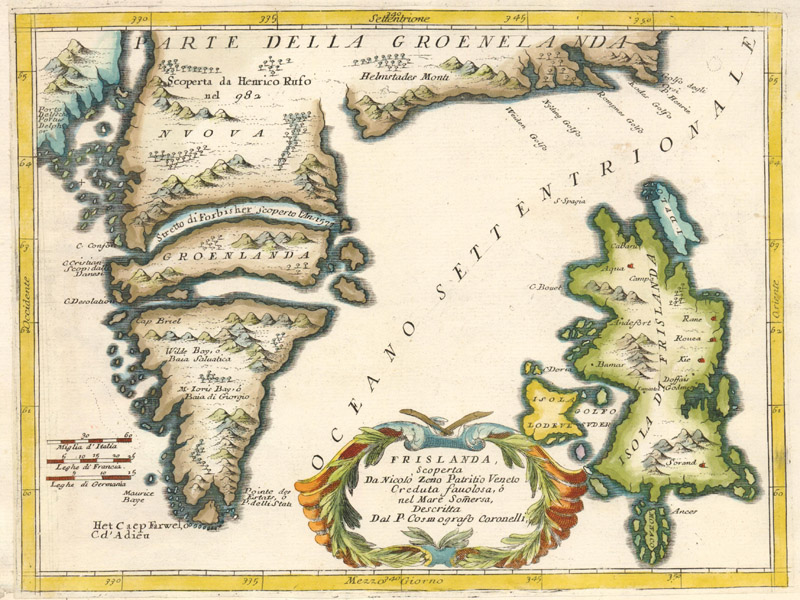
Frislanda, Scoperta da Nicolo Zeno Patritio Veneto Creduta Favolosa, ‘o nel Mare Somersa, Descritta by Vincenzo Maria Coronelli (ca. 1696)
Frisland and the (Not So True) Adventures of the Zeno Brothers
by Joe McAlhany
There once existed an island in the North Atlantic called Frisland - at least according to several maps published from the late 16th century into the late 18th century. It first appeared on the “Zeno map” in 1558 and was soon found on maps by respected and influential cartographers like Ruscelli, Mercator, and Ortelius. A landmass larger than Ireland, located south of Iceland, Frisland would have looked to the casual early modern observer as legitimate on paper as neighboring Greenland, maybe even more so. Its coastline was well-defined, with clusters of smaller islands surrounding it and a smattering of towns identified inland. The English explorer Martin Frobisher seemed to confirm its existence on all three of his voyages. On his first outing in July 1576, Frobisher passed what he believed to be the mountainous coast of Frisland. After spotting the island again a year later, the expedition’s chronicler, George Best, compared it to Frisland as depicted on the Zeno map: “For so much of this land as we have sayled alongst, comparing their carde [the Zeno map] with the coast, we find it very agreeable.” And on the third voyage, in 1578, Frobisher actually came ashore and claimed Frisland for Queen Elizabeth, dubbing it “Anglia Occidentale.”
So why can’t we take a cheap flight to visit the Frislandan city of Sorand the same way we might travel to Reykjavík? What happened to the mysterious island? Like so many distant lands found on old maps, the island of Frisland belongs exclusively to the curious realm of cartographic myths. Along with nearby phantom lands like Icaria and Drogeo, Frisland was an invention of the Venetian Senator, writer, mathematician, and geographer Nicolò Zeno the Younger (1515-65). Frobisher did not verify the reality of Frisland - he mistook Greenland for a fantasy. Of course, he was not the only one fooled by Zeno the Younger’s account. Frisland lived on for centuries on maps and in the imaginations of countless Europeans eager for new worlds to explore and conquer.
Rather than start the convoluted story of Frisland in 1380, when the island was allegedly discovered, it makes more sense to begin more than a century later, in Zeno the Younger’s childhood. According to his account, Zeno found a stash of letters written by his 13th-century ancestors, the brothers Nicolò and Antonio Zeno, when he was just a boy. [Sources date Nicolò’s lifespan from ca. 1326 - ca. 1402, and mark Antonio’s death around 1403. But as we shall soon see, in the account of their adventures, Antonio lives on for a decade after Nicolò’s death. The discrepancy in the facts here is typical of the spurious history of Frisland.] The letters told of astonishing adventures in the North Atlantic, but in an act of youthful folly, Zeno the Younger destroyed the documents soon after reading them. Years later, he realized that he had torn up an incredible chapter of history and sought to reconstruct from memory the story of his ancestors’ expedition into the unknown.
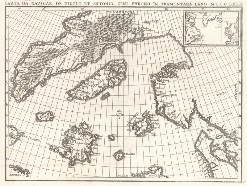
The result was Dello Scoprimento dell’isole Frislandia, Eslanda, Engrouelanda, Estotilanda, & Icaria, fatto sotto il Polo Artico, da due Fratelli Zeni (1558), a brief epistolary chronicle of the Zeno brothers’ escapades in the North Atlantic that was accompanied by Carta da Navegar de Nicolo et Antonio Zeni Furono in Tramontana Lano MCCCLXXX, also known as the Zeno map. The account was folded into a longer work celebrating the long lineage of Zenos of influence throughout the history of Venice, but it was the tales of Frisland and surrounding lands that captured the public’s attention.
A faithful reproduction of the Zeno map, from Placido Zurla’s Sulle Antiche Mappe Idro-Geografiche Lavorate in Venezia (1818) (the inset at top right is a modern addition)
Dello Scoprimento begins with a description of a letter from Nicolò (the Elder) to his brother Antonio. As the letter tells it, in 1380, Nicolò departed Venice for England and Flanders, only to be diverted to the north by a violent storm. He shipwrecked on an island called Frisland, where he met a prince named Zichmni. Zichmni not only spoke Latin, but he was familiar with Italy and was thrilled to be in the presence of a Venetian. The ruler took an immediate liking to Nicolò and consulted with him as he plotted to take over the nearby islands of Ledovo, Ilofe, and Sanestol. So grateful was Zichmni for Nicolò’s valor and naval expertise that he knighted the Venetian. Nicolò then invited his brother Antonio to the island. Antonio soon became captain of Zichmni’s fleet and joined the ruler for a 14-year campaign of exploration and combat.
Nicolò only survived for the first four years after his brother’s arrival. He voyaged alone to Engroenlant (Greenland), where he apparently found a monastery with a central heating system. (His account devotes a disproportionate amount of attention to this strange discovery.) However, even with the benefit of central heating, the extreme cold of Greenland took its toll on Nicolò. He died soon after returning to Frisland.
The second part of the Dello Scoprimento consists of a summary of Antonio’s letters to his other brother Carlo (1333-1418), a wealthy merchant and hero of the War of Chioggia. After Nicolò’s death, Zichmni would not grant Antonio permission to return to Venice. The prince harbored ambitions to become “master of the sea,” and required Antonio’s naval prowess to achieve his goal. At this point, Antonio’s account becomes a story-within-a-story as he recounts details of a 26-year fishing expedition west of Frisland. A surviving fisherman returned to Frisland with news of an island called Estotiland. He described Estotiland as smaller than Iceland, but with more fertile land; it was populated by intelligent, civilized people with old Latin books, likely from past encounters with Europeans; and it was rich in metals - chief among them gold. The fisherman also noted another land farther to the south called Drogeo, a more hostile country inhabited by (who else?) bloodthirsty cannibals.
Intrigued by the fisherman's tales, Zichmni ordered Antonio to venture westward in search of this “new world.” What he found instead was an island called Icaria, ruled by descendants of Daedelus, a legendary Scottish king. The Icarians had ironclad laws that forbade foreign men from setting foot on their soil, so Antonio and his crew pretended to leave and snuck over to the eastern side of the island for supplies. However, they were caught in the act and forced to defend themselves against the Icarian horde. The crew escaped and circled the island, which presumably enabled them to map its coast for the Zeno map.
After the episode in Icaria, Antonio and Zichmni landed in southern Greenland, where Zichmni established a new settlement. Antonio returned to Frisland, and then to Venice, where he died in the early 15th century. He never reached Estotiland or Drogeo. In the last fragment of the letters that Zeno the Younger remembers, Antonio synopsizes a book he wrote that contains in-depth descriptions of the land and customs of Frisland, Greenland, Iceland, Shetland, Norway, Estotiland, and Drogeo, as well as biographies of his brother Nicolò and of Zichmni. Dello Scoprimento ends with Zeno the Younger lamenting the loss of his heroic ancestors’ manuscripts, noting that he has done his best to reconstruct the lost works and to honor the Zeno brothers’ exploits.
Of course, we now know that Frisland and the other islands described in Zeno the Younger’s book do not exist, at least not as described. By today’s standards, his story is laughable as history, nothing more than secondhand hearsay, with no surviving primary documents to confirm his claims. But his compelling narrative quickly took root in the European imagination. After all, as Genevieve Carlton writes in her article “How to Put a Fake Island on the Map,” “Hope, plus a veneer of truth, transformed Frisland into a real island. People believed it was true because it fit with what they wanted to find in the ocean: rich, untouched lands ready for Europeans to exploit.”
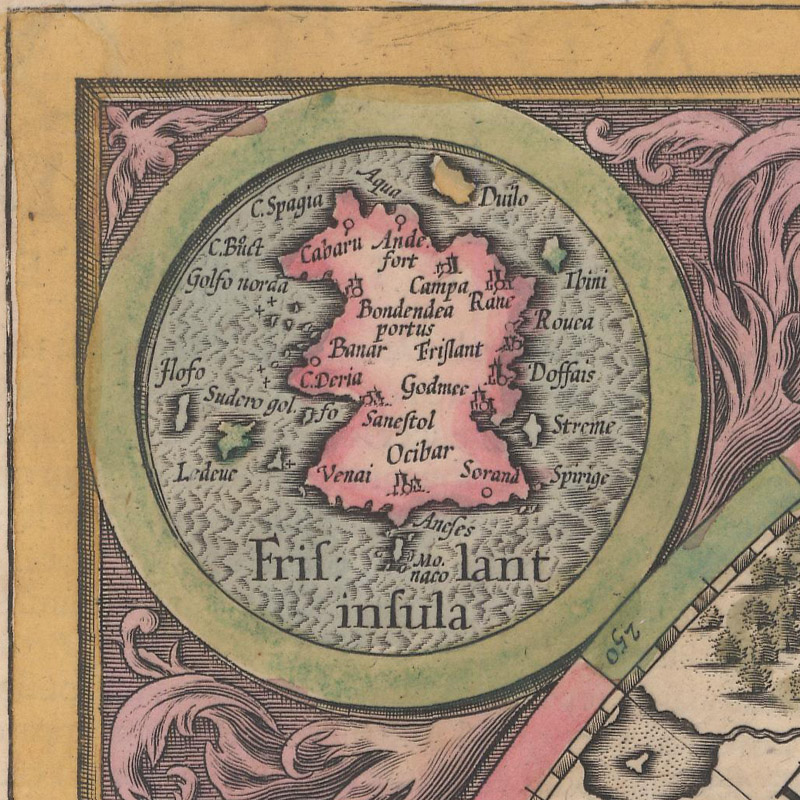
And if people wanted evidence, there was Zeno’s woodcut map. Zeno the Younger was able to restore the damaged map left by his ancestors, illustrating their astonishing finds. Although the map was allegedly drawn in the late 14th century, much of its cartography was contemporary, lending legitimacy to Zeno’s fictitious territories. The map’s depiction of Scandinavia was more or less in line with other maps of the 16th century. Although vast, mountainous Greenland connects to Scandinavia in the north, it is relatively well-shaped. Iceland is accurately located, albeit with some phantom satellite islands (perhaps the mislocated Faroe Islands), and there is a fragment of northern Scotland at bottom. Estland, a group of islands to the west of Norway, is thought to be the Shetland Islands. The position of Estotiland, generally accepted today as Zeno’s take on Labrador or Newfoundland, matches up with John Cabot’s 1497 expedition along the North American coast. Situated in the context of these real places, Frisland, Icaria, Podalida, and Drogeo looked real too. Frisland is by far the most detailed of these spurious islands - even more detailed than some of the actual islands. It is no wonder it was almost immediately incorporated into maps by other cartographers.
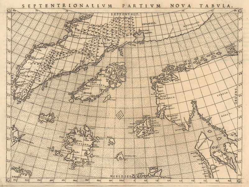
Septentrionalium Partium Nova Tabula by Girolamo Ruscelli (1561)
In 1561, just a few years after the publication of the Zeno map, Girolamo Ruscelli included Septentrionalium Partium Nova Tabula, a reduced version of the Zeno map, in his edition of Ptolemy’s Geographia. The only significant cartographic difference between the two maps is that Ruscelli keeps the connection between Greenland and Scandinavia ambiguous; otherwise, Frisland and all the other phantom islands are reproduced. In his introduction to the text, Ruscelli specifically praises Zeno the Younger’s superior knowledge of geography and history. Over the course of the next 38 years, Ruscelli included the map in every edition of his popular and influential work.
Septentrionalium Terrarum Descriptio by Gerardus Mercator (1628)
Frisland appeared on Gerardus Mercator’s epochal world map of 1569, one of the most important maps in the history of cartography. This further cemented the “authenticity” of Frisland and guaranteed that cartographers would continue to propagate the myth. Drogeo is also depicted on the world map, but whereas Zeno and Ruscelli only show a portion of its coast in the bottom left corner of their maps, Mercator completely delineates the island’s coastline. When Mercator published his beloved map of the North Pole, the first printed map devoted to the Arctic, he not only includes Frisland - he singled it out in one of the four medallions surrounding the map. In Mercator’s rendering, the island is virtually identical to the Zeno map.
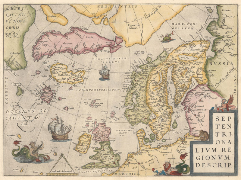
Septentrionalium Regionum Descrip. by Abraham Ortelius (1570)
Abraham Ortelius, the father of the modern atlas, also bought into the dream of Frisland. “Frieslant” and Drogeo are there in the North Atlantic in his world map of 1570 (and Newfoundland and Labrador are labeled “Estotilant”). Septentrionalium Regionum Descrip., his riff on the Ruscelli map of the northern regions, prominently featured Frisland, albeit with slightly vaguer features. (F.J. Manasek suggests, “Perhaps this was Ortelius’s way of hedging a bit.”) His completely mapped island of Drogeo certainly owes a debt to the Mercator world map. The appearance of Frisland in Ortelius’ atlas had real world ramifications. Frobisher consulted the Theatrum Orbis Terrarum on his voyages, and John Dee, the political advisor who sold Elizabeth I on the concept of a “British Empire,” claimed Greenland, Frisland, and Estotitland as British subjects upon seeing them in the atlas.
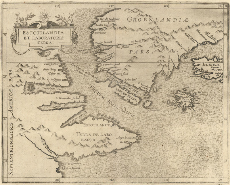
Estotilandia et Laboratoris Terra by Cornelis Wytfliet (1597)
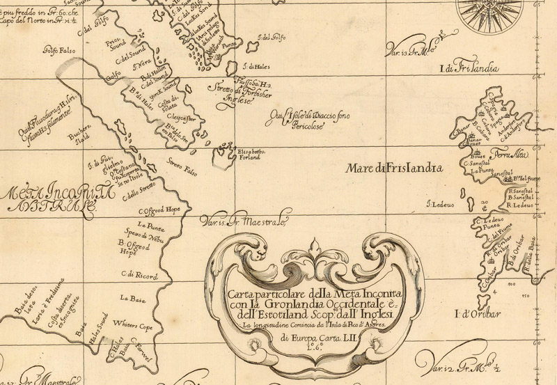
Zeno’s myths were given credence in other publications of note: the fourth volume of Giovanni Battista Ramusio’s Delle Navigationi e Viaggi (1583); Richard Hakluyt’s Divers Voyages (1582) and Principal Navigations (1600); and Samuel Purchas’ His Pilgrimes (1625) (although Purchas had his reservations about the accuracy of Zeno’s account). The island of Frisland was a fixture on maps showing the North Atlantic for the next century. It lies between Greenland and Iceland on Cornelis Wytfliet’s Estotilandia et Laboratoris Terra (1597), the first printed map to detail the terrain covered in the Frobisher and Davis expeditions. A fragment of its coastline peeks in from the northernmost extent of John Speed’s iconic 1626 map of the Western Hemisphere. It shows up on maps of Europe by Gerard de Jode, Jodocus Hondius, Willem Blaeu, and Matthaus Merian. Sir Robert Dudley’s chart of the North Atlantic (1661) features a surprisingly detailed view of Frisland’s western coast, right next to the Mare di Frislandia. At the end of the 17th century, the great Italian cartographer Vincenzo Maria Coronelli made a map spotlighting Frisland, although the title, Frislanda, Scoperta da Nicolo Zeno Patritio Veneto Creduta Favolosa, ‘o nel Mare Somersa, Descritta, suggests that the island is “believed to be fabulous.”
Frisland and the Mare di Frislandia from Sir Robert Dudley’s Carta particolare della Meta Inconita con la Gronlandia Occidentale e dell'Estotiland… (1661)
Frisland occasionally turns up on later maps, usually as a free-floating stretch of coastline, but by the 18th century, the North Atlantic was increasingly well-charted, with no new evidence of the island. But even after Zeno’s myths faded from maps, historians and academics continued to debate the merits of his Dello Scoprimento. Most seem to agree that the Zeno brothers did venture out on an expedition, but the historical record does not bear out Zeno the Younger’s timeline. (For instance, from 1390 to 1392, when Nicolò Zeno was supposed to be in the company of the great Zichmni, he was actually back home in Venice, standing trial for embezzlement.) In the 19th century, the idea that the Zeno letters and map were a deliberate fraud began to gain traction. Danish admiral Christian Zahrtmann dismissed Dello Scoprimento as a work of fiction in 1835, and, in 1898, Frederick W. Lucas published The Annals of the Voyages of the Brothers Nicolo and Antonio Zeno in the North Atlantic, a passionate evisceration of Zeno’s bogus geography.
When the Hakluyt Society published an English translation of Zeno’s account in 1873, editor Richard Henry Major attempted to salvage the work’s reputation, arguing in his introduction for the veracity of Zeno’s tale. More than a century later, in 1989, the Venetian philologist Giorgio Padoan claimed that Zeno the Younger did possess his ancestors’ actual letters and a real map, and that Estotiland is an early depiction of Nova Scotia. The Italian writer, journalist, and scholar of Venetian history Andrea di Robilant published Irresistible North: From Venice to Greenland on the Trail of the Zen Brothers in 2011. More than 450 years after Dello Scoprimento first appeared, di Robilant attempts to retrace the Zeno brothers’ journey and to relitigate the authenticity of their discoveries. Zeno the Younger’s account may have been debunked, but it will not stay buried.
Perhaps debating whether or not Zeno the Younger purposefully set out to deceive the world, invent new lands, and elevate his family name is to miss the point. In her fascinating article, “Venetians in America: Nicolò Zeno and the Virtual Exploration of the New World,” scholar Elizabeth Horodowich makes a provocative and persuasive case for reading Dello Scoprimento in the same tradition as the Prester John letter or Columbus’ account of his own voyage, as a collage-like travelogue that blends fact and fantasy in the interest of giving the Venetians a New World chronicle of their own. “[Zeno’s] text was not a trick, a fraud, or an empirical account of events, but represented the methodical creation of a skillful and patriotic author,” she writes. “In the end, it cannot be classified as either history or fiction: like many early modern travel accounts, it was always a combination of both.”
In that spirit, let us consider the island of Frisland as a gift: to the Venetians, hungry for a great discovery of their own; to the English, eager to claim any lands, even fake ones, in their quest for empire; to the early modern European imagination, with its bottomless curiosity for unknown lands; and to today’s map collectors, who continue to be fascinated by the origins and trajectories of cartographic myths.
REFERENCES
Brooke-Hitching, Edward, The Phantom Atlas – The Greatest Myths, Lies and Blunders on Maps, Chronicle Books LLC., San Francisco, 2018.
Carlton, Genevieve, “How to Put a Fake Island on the Map,” Atlas Obscura, December 4, 2017. https://www.atlasobscura.com/articles/zeno-map-phantom-island-cartography
Horodowich, Elizabeth, “Venetians in America: Nicolò Zeno and the Virtual Exploration of the New World,” Renaissance Quarterly Vol. 67, No. 3 (Fall 2014), pp. 841-877. https://www.jstor.org/stable/10.1086/678776
Major, Richard Henry (ed.), The Voyages of the Venetian Brothers, Nicolò & Antonio Zeno, to the Northern Seas in the XIVth Century: Comprising the Latest Known Accounts of the Lost Colony of Greenland and of the Northmen in America Before Columbus, The Hakluyt Society, London, 1873. https://archive.org/details/voyagesofvenetia00zenorich
Manasek, F.J., “Frisland - Phantom Island of the North Atlantic,” Mercator’s World Volume 2, Number 1, January February 1997.
Wood, Tony, “Confections of Zeno - The Consequences of Cartographic Fantasy,” Cabinet Issue 18, Summer 2005. https://www.cabinetmagazine.org/issues/18/wood.php