Filtered by Category:Atlantic & Arctic(Show All Categories)
Current Auction
15 lots
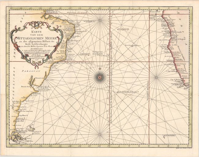
Lot 341
Subject: South Atlantic
Bellin, Jacques Nicolas
Karte von dem Mittaeglichen Meere, zu der Allgemeinen Historie der Reise-Beschreibungen, 1746
Size: 17.8 x 13.4 inches (45.2 x 34 cm)
Estimate: $160 - $190
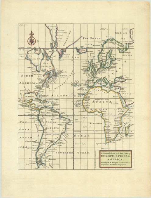
Lot 342
Subject: Atlantic Ocean
Moll, Herman
A General Chart of the Sea Coast of Europe, Africa & America. According to E. Wrights or Mercator's Projection, 1720
Size: 11.1 x 14 inches (28.2 x 35.6 cm)
Estimate: $240 - $300
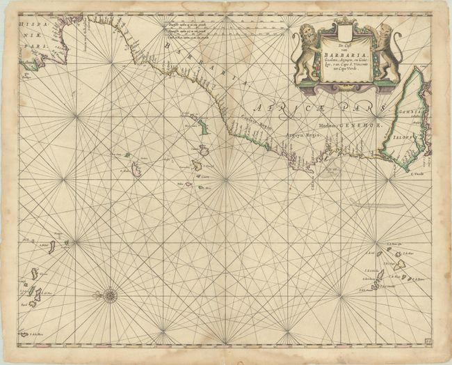
Lot 343
Subject: Eastern Atlantic Ocean
Goos, Pieter
De Cust van Barbaria, Gualata, Arguyn, en Geneheo, van Capo S. Vincente tot Capo Verde, 1666
Size: 20.8 x 16.8 inches (52.8 x 42.7 cm)
Estimate: $275 - $350
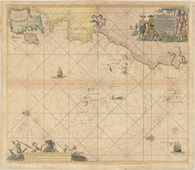
Lot 344
Subject: Eastern Atlantic Ocean
Keulen, Johannes van
Nieuwe Paskaert vande Gheheele Westersche Scheep-Vaert..., 1680
Size: 23.1 x 20.1 inches (58.7 x 51.1 cm)
Estimate: $700 - $850
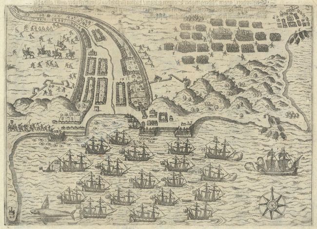
Lot 345
Subject: Praia, Cape Verde Islands & Santo Domingo, Hispaniola
Bry, Theodore de
[The English Attack Praia in the Cape Verde Islands] [on verso] [Francis Drake Attacks the Town of Santo Domingo], 1617
Size: 8.4 x 6.1 inches (21.3 x 15.5 cm)
Estimate: $100 - $130
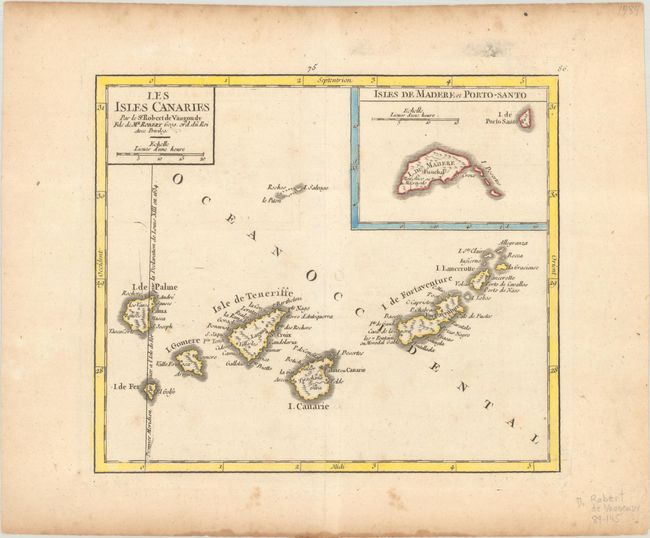
Lot 346
Subject: Canary Islands & Madeira
[Lot of 2] Les Isles Canaries [and] Carte des Isles Canaries, avec l'Isle de Madere et celle de Porto Santo, 1749-80
Size: See Description
Estimate: $120 - $150
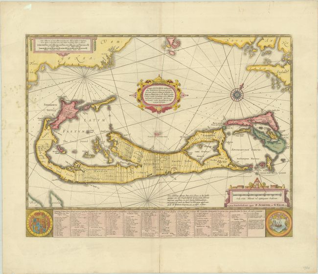
Lot 347
Subject: Bermuda
Jansson/Valck & Schenk
Mappa Aestivarum Insularum, Alias Barmudas Dictarum, ad Ostia Mexicani Aestuary..., 1700
Size: 20 x 15.3 inches (50.8 x 38.9 cm)
Estimate: $750 - $900
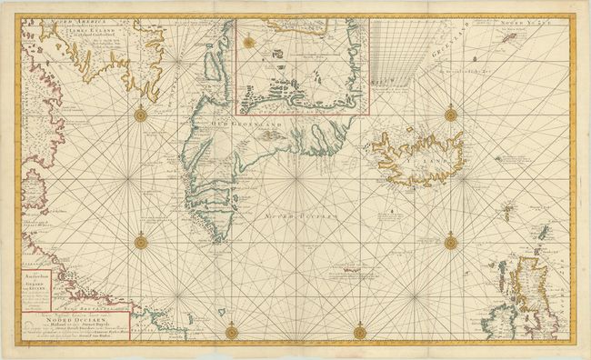
Lot 348
Subject: North Atlantic
Keulen, Gerard van
Nieuwe Wassende Graeden Kaert van de Noord Occiaen, van Hitland tot inde Straet Davids..., 1720
Size: 39.1 x 23.1 inches (99.3 x 58.7 cm)
Estimate: $700 - $850
Includes Remnant of the Mythical Island of Friesland
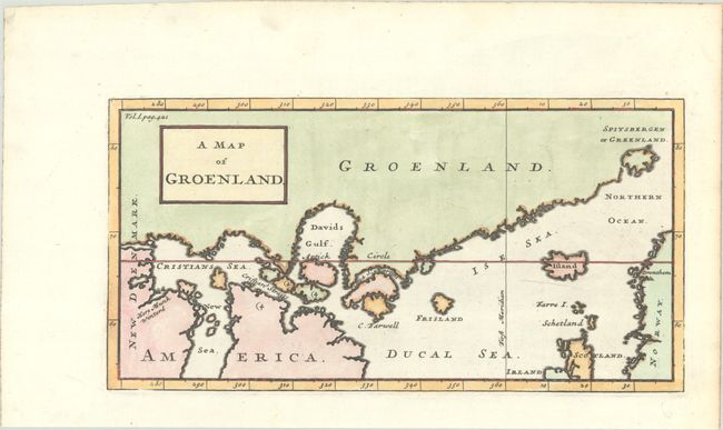
Lot 349
Subject: North Atlantic, Greenland
Churchill, John
A Map of Groenland, 1744
Size: 11 x 5.6 inches (27.9 x 14.2 cm)
Estimate: $140 - $170
Lot 350
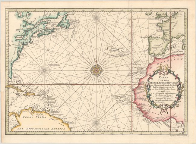
Subject: North Atlantic
Bellin, Jacques Nicolas
Karte von dem Abendlaendischen Ocean zur Allgemeinen Historie der Reise Beschreibungen Entworfen, 1746
Size: 17.9 x 12.4 inches (45.5 x 31.5 cm)
Estimate: $200 - $230
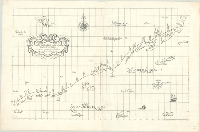
Lot 351
Subject: Southeastern Greenland
Dudley, Robert (Sir)
Carta Particolare della Gronlandia Orientale..., 1647
Size: 29.6 x 18.8 inches (75.2 x 47.8 cm)
Estimate: $800 - $950
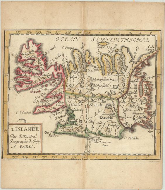
Lot 352
Subject: Iceland
Duval, Pierre
L'Islande, 1682
Size: 5.2 x 4.3 inches (13.2 x 10.9 cm)
Estimate: $240 - $300
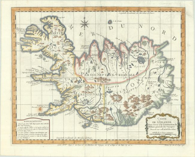
Lot 353
Subject: Iceland
Bellin, Jacques Nicolas
Carte de l'Islande, pour Servir a la Continuation de l'Histoire Generale des Voyages, 1758
Size: 15.1 x 12 inches (38.4 x 30.5 cm)
Estimate: $160 - $190
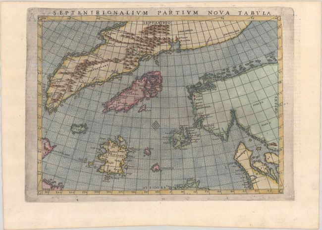
Lot 354
Subject: Arctic & Scandinavia
Ruscelli, Girolamo
Septenirionalium Partium Nova Tabula, 1574
Size: 9.4 x 6.9 inches (23.9 x 17.5 cm)
Estimate: $700 - $850
Reduced Version of Zeno Map with Mythical Islands
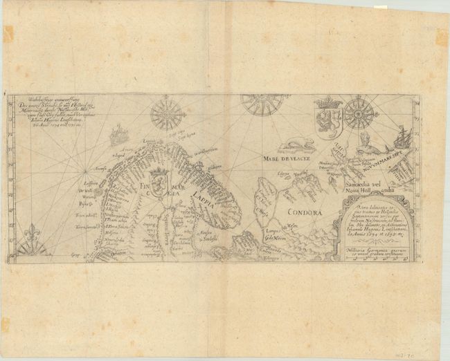
Lot 355
Subject: Arctic & Scandinavia
Bry, Theodore de
Vera Delineatio Totius Tractus ex Hollandia Septentrionem Versus per Fretrum Nassovicum... / Wahrhafftige Entwerffung des Gantze Streichs, so aus Holland get Mitternacht Durchs Nassawische..., 1613
Size: 13.3 x 5.4 inches (33.8 x 13.7 cm)
Estimate: $800 - $950
15 lots