Subject: Colonial Gulf Coast
Period: 1752 (dated)
Publication:
Color: Black & White
Size:
36.4 x 20.4 inches
92.5 x 51.8 cm
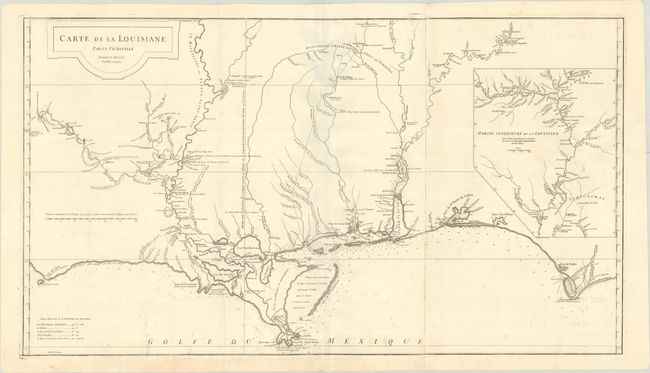
This large and graphic map is one of the earliest detailed depictions of French settlements on the Gulf Coast. It extends along the coast from Cabo del Norte in the west to Cabo Escondido, and in the interior from Province de Tecas east to Apalachicola River in Florida. The map features very fine detail along the coast, particularly in the areas of New Orleans, Pasagoula, Mobile and Mobile Bay, Baye de Ste. Marie de Galbes (Pensacola Bay), and St. Josephs Bay. It includes remarkably accurate mapping of the course of the Red, Mississippi, Pearl, Pascagoula, Tchicachas (Tombigbee), and Alabama rivers and tributaries. Numerous notes on Indian villages and forts are found in the interior. The large inset at right, Partie Superieure de la Louisiane, maps the course of the Mississippi River to its confluence with the Missouri and beyond. Due to the map's overwhelming popularity, it was frequently reprinted throughout the remaining years of French Louisiana. Printed on two sheets, joined as issued.
References: Phillips (Atlases) #571-35; Lemmon, Magill & Wiese #24.
Condition: B+
A crisp impression on sturdy paper with a birdhouse watermark. There is a printer's crease at bottom and light soiling mostly at bottom.