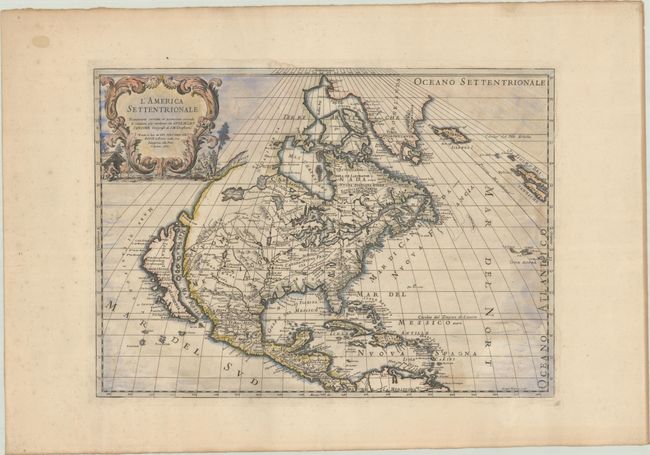
Subject: Colonial North America
Period: 1715 (circa)
Publication: Mercurio Geographico
Color: Hand Color
Size:
21.4 x 15.4 inches
54.4 x 39.1 cm
This is the updated third state of Rossi's fine map of North America, based on the seminal Sanson map of the region. As in the Sanson version, California is shown as an island on the Foxe model with two northern bays. The Great Lakes are now shown with complete western shorelines, and there is new information introduced in western Canada, which appears to be derived from Baron de Lahontan's landmark Carte Generale de Canada (1703). The Mississippi River now veers westward and empties into the gulf in present-day Texas. The R. del Norte (Rio Grande) now flows correctly into the Gulf of Mexico taken from the Coronelli/Nolin map of New Mexico (1687). The new Stretto d'Anien is placed in the Pacific Northwest leading toward Hudson Bay and insinuating a possible Northwest Passage. The east coast remains unchanged with none of the new colonies shown. Dated 1687 in the cartouche but likely published circa 1715.
References: Burden #491; McLaughlin #65.
Condition: B+
A crisp impression on watermarked paper with some light foxing and dampstaining along the borders. There are three small seller's stamps in the bottom blank margin.