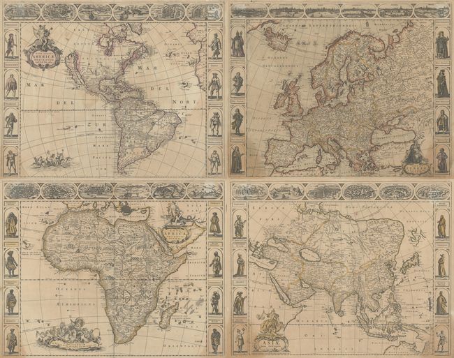
Subject: Continents
Period: 1668 (circa)
Publication:
Color: Hand Color
Size:
21.9 x 17.4 inches
55.6 x 44.2 cm
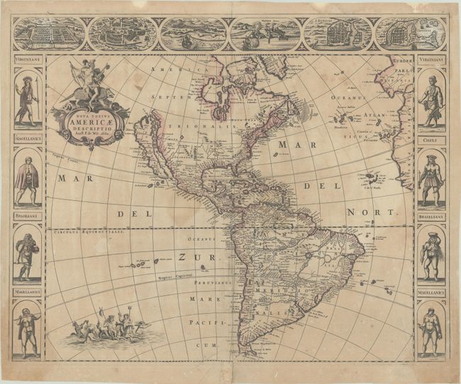
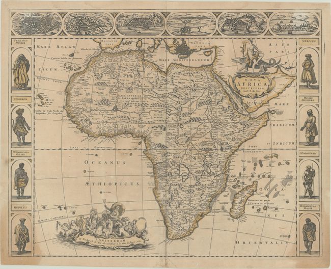
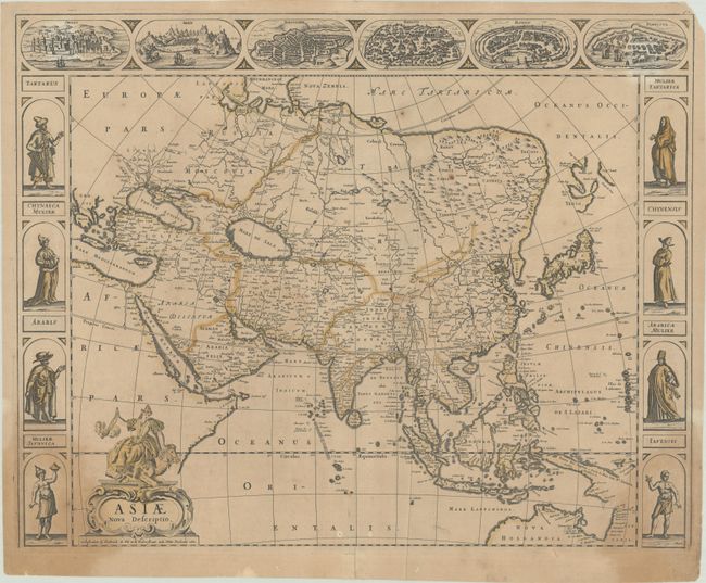
This magnificent set of carte-a-figures maps of the four continents was issued by noted Dutch map publisher, Frederick de Wit. While the first three are dated 1660, these maps were published in an early de Wit atlas circa 1668-1670. According to Carhart, they are all in the second state with "fo." plus page number in the upper right corner.
A. Nova Totius Americae Descriptio, dated 1660. An uncommon and splendid carte-a-figures map of the Americas. The map combines many different sources including the Luke Foxe model of the island of California. The only hint of the Great Lakes is a small L. Contenant at the end of the St. Lawrence River. Nieu Neder Land occupies the eastern seaboard and there is no mention of any English settlement other than the name Virginia. In South America a large river and lake system provides the boundary of Brazil, with the mythical lake Eupana Lacus. A second mythical lake, Parime Lacus, is shown along the equator. The decorations were taken from van den Keere's map of 1614. The figures at sides depict the natives of Virginia, Magellanica, and Brazil, and the cities across the top include Cusco, Mexico, Olinda, Havana, S. Dominique, and Cartegena. The map is further embellished with a title cartouche bearing a native Indian mounted on an armadillo, and Neptune frolicking in the Pacific with mermaids and sea horses. Additional references: Burden #356; McLaughlin #24; Tooley (America) #18.
B. Nova Africa Descriptio, dated 1660. This uncommon map of Africa shows views of Cairo (Alcair), Alexandria, Algiers (Alger), Tunis, Tangiers (Tanger), and Ceuta across the top, which are close copies from Jodocus Hondius' map of Africa from 1623. The figures at both sides of the map are nearly identical to those from Van den Keere's Africa map of 1614, with the exception of the top two (Congensis and Mulier Abissinea). The geography on the map is based on Jodocus Hondius' Africae nova Tabula from 1623, which was copied from Willem Blaeu's Africae nova Descriptio from 1617, although De Wit omits the engravings of animals in the interior. The Nile is shown according to Ptolemy with its sources arising in the lakes Zaire and Zaflan, the fictitious Lake Sachaf of Laurent Fries appears, as well as the R. de Spirito Santo. Additional reference: Betz #96.2.
C. Asiae Nova Descriptio, dated 1660. This is a splendid example of one of the last Dutch carte-a-figures continental maps. The continent is shown with the northern and eastern coastline of mainland Asia on the Mercator-Hondius model. It incorporates the discoveries made by the 1643 De Vries expedition and the discoveries of Le Maire in New Guinea. The map is illustrated with flanking panels featuring costumed figures from China, Tartary, Arabia and the East Indies. The panels above show panoramas and plans of Ormus, Aden, Jerusalem, Damascus, Rhodes and Famagusta. The title cartouche is adorned by a female representation of the continent riding a camel. Additional reference: Yeo #51.
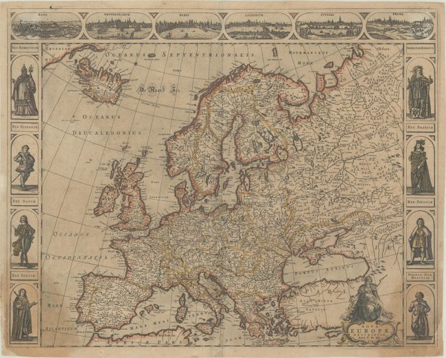
D. Nova Europae Descriptio, circa 1668. A stunning map of Europe extending to include Iceland and a bit of Greenland. It is flanked at sides with portraits of eight European monarchs. Six vignette views at top show the cities of Rome, Amsterdam, Paris, London, Seville and Prague. The map is very finely engraved and further embellished with a title cartouche surmounted by the personification of Europa.
References: Carhart #5.2, 7.2, 9.2 & 18.2.
Condition: B
There is light toning and dampstains flanking the centerfold and in the bottom corners. There are archival repairs to some small centerfold separations that are mostly in the maps of the Americas and Europe. The map of Europe also has some scattered foxing. The versos have hinge and paper tape from previous framings, with some light staining visible in the top corners on recto.