Subject: World
Period: 1594 (dated)
Publication:
Color: Black & White
Size:
22.8 x 16 inches
57.9 x 40.6 cm
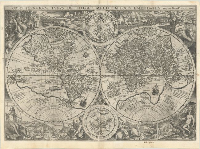
This handsome world map was first issued separately in 1594, and then included in Linschoten's Itinerarium beginning in 1599. It was the first world map to feature lavishly decorated borders, and inspired cartographic embellishments for more than a century. The map was based on Plancius' world map of 1590, which in turn was based on Rumold Mercator's map of 1587, with the addition of numerous decorative elements. The vignettes surrounding the map use female figures and animals to represent the various regions around the world. Europa and Asia are depicted at top with elegant costumes, likely to indicate their superior culture and dominance over Mexicana (North America), Peruana (South America), Magallanica (the still hypothetical Antarctica), and Africa, who appear at the bottom of the sheet. Mexicana, Peruana, and Africa are shown only partially clothed and with rudimentary man-made structures behind them. With the exception of civilized Europa, each of the female figures is riding on an animal believed to be indigenous to the area, including a rhinoceros, a giant armadillo, a leopard, an elephant, and a crocodile. Between the two hemispheres are two celestial spheres, an armillary sphere, and a 32-point compass rose.
The map incorporates the improvements made by Ortelius with a re-shaped South America and inclusion of the Solomon Islands. Plancius introduced new information, based on Portuguese reports, on the far-west coast of America and the western coastline of Africa. In addition, Virginia is noted on the east coast, a relatively early appearance. The Far East is depicted more accurately than on his 1590 world map, with Korea shown as a peninsula and Japan shown with better proportions, based on the work of Luiz Teixeira. The massive southern continent has changed shape from Plancius' previous map, with Nova Guinea now attached to the continent. In the arctic, Novaya Zemlya has been updated as an island. Skillfully engraved by Jan van Doetecum, whose imprint appears at bottom left.
References: Shirley #187.
Condition: A
A superb, dark impression, issued folding on heavy paper with a crossed arrows watermark. There are a couple of printer's creases along the centerfold at bottom, and one tiny hole at a fold intersection in North America. There are professional repairs to a minor tear just above the armillary sphere and to several short fold separations along the edges of the sheet. There are two old, manuscript ink notations in the blank margins. This map is very rarely seen with such an excellent impression and on such high-quality paper.