Subject: World
Period: 1525 (published)
Publication: Claudii Ptolemaei Geographicae
Color: Black & White
Size:
18.1 x 11.3 inches
46 x 28.7 cm
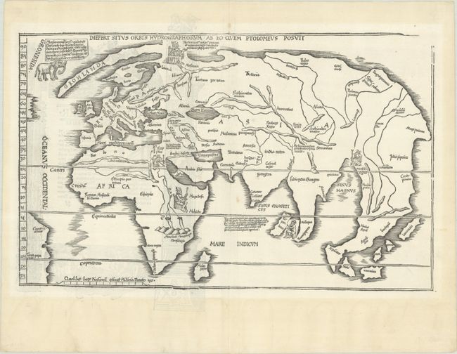
This is one of two 'modern' world maps included in Fries' Ptolemaic atlas and one of the few early 16th century world maps available to collectors. It is a reduced version of Waldseemuller's famous Admiral's Map, concentrating on the Old World but showing parts of America at the left side. It shows the world in a combination of classical misconceptions with a few of the more recent discoveries, such as a bit of the coastline of South America along the left border. Greenland is drawn as an elongated peninsula connected to a still primitively shaped Scandinavia. Fries' adaptation presents the mountains in a different stylized manner and lacks the directional lines of the Waldseemuler plate. Decorative elements have been added including an elephant just off the coast of Greenland and portraits of five kings: Russia, Egypt, Ethiopia, Toprobana and Mursuli. It provides a fascinating view of what was known, and not known, of the world at the beginning of the Age of Discovery. The upper right corner of the border is lacking, as is the case with editions from 1525 to 1541. Latin text and elaborate woodblock engravings on verso.
References: Shirley #49; Mickwitz & Miekkavaara #208-49.
Condition: A
A sharp impression on a bright sheet with an anchor watermark and a couple of tiny worm tracks in the image that have been professionally repaired. There is minor toning outside of the map image.