Subject: World
Period: 1650 (circa)
Publication:
Color: Hand Color
Size:
21.3 x 15.4 inches
54.1 x 39.1 cm
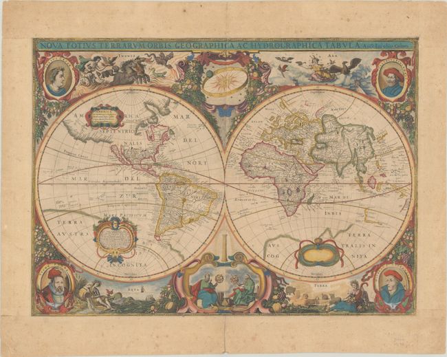
Jacob Colom based his baroque-style world map on Henricus Hondius' map from 1630. The map features hemispheres surrounded by voluptuous representations of the four elements: Fire by Apollo driving the Sun's chariot across the sky; Aeros, the goddess of Air, surrounded by clouds and birds; Mother Earth, surrounded by animals and the earth's bounty; and Water represented by a Siren and sea monsters. Four portraits fill the corners, and while Colom copies the upper portraits of Julius Caesar and Claudius Ptolemy, he replaces the lower portraits of Jodocus Hondius and Gerard Mercator with Tycho Brahe and Copernicus. Colom also updates the decorative cartouches between the cusps, featuring instead a vignette of two astronomers holding armillary spheres.
Geographically, Colom's map also closely copies Hondius' map, with a few updates. California as presented as an island, and the northwest coast of North America extends far west with the name Nova Albion. The faint outline of Terra Australis Incognita is also still in evidence. However, Colom makes several important updates. The shape of Quebec and Labrador is much improved and Tierra del Fuego is completely delineated. In addition, the Dutch discoveries on the west coast of Australia are shown. In Asia, Colom makes a few interesting changes, such as eliminating the northern coast of Japan and much of the cartography within China, possibly because the cartography of those regions was still speculative.
Jacob Aertsz Colom was the founder of the Colom publishing company. He founded the Navigation School in Amsterdam, and published a number of fine sea charts, coasting pilots and a small atlas of Belgium and The Netherlands. Colom's maps and charts are quite rare. This map was first separately issued, and then included in Colom's sea atlases in the 1650s and 1660s.
References: Koeman, J. Col 1 #1; Shirley #381.
Condition: B
An old-colored example on a moderately toned sheet with light foxing that is mostly confined the blank margins. There is an extraneous horizontal crease, two minute holes in the image, and the margins have been reinforced with old paper. A fold separation at bottom and a few minor edge tears have been repaired with archival tape on verso.