Subject: Colorado & Kansas
Period: 1859 (dated)
Publication: A New Universal Atlas...
Color: Hand Color
Size:
27 x 16.1 inches
68.6 x 40.9 cm
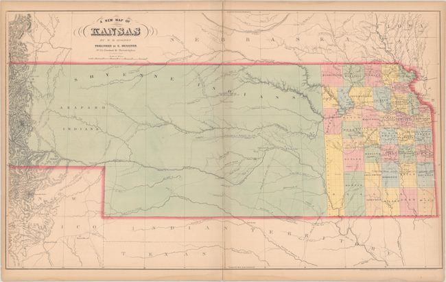
This rare map of Kansas Territory was issued in only a few late editions of Desilver's A New Universal Atlas. Kansas Territory was created in 1854 and extends here from the Missouri River to the Continental Divide, including present-day eastern Colorado. The map was issued during the Pike's Peak gold rush and a large "Gold Field" is prominently labeled along the Front Range. Place names of interest in this region include Auraria, Montana, "Bubbling Mineral Spring" (future Colorado Springs), and Denver City, which was established in November 1858 making this one of the earliest maps to identify Denver. In the eastern portion of the territory, county development extends to just beyond the 99th meridian though most of the population is to the north and east of Topeka with LeCompton as the territorial capital. In between are various explorer routes including Fremont, Summer, Woodruff, Pope, Boone and the ranges of the Cheyenne and Arapaho Indians. With the increase in both population and economic activity related to the gold rush, Colorado Territory was formed in 1861.
We found only 4 past sales records for this map in the last 30 years.
References: Rumsey #6727.040.
Condition: B+
Contemporary color with light offsetting, minor toning along the centerfold, and a narrow dampstain confined to the bottom blank margin. A few short centerfold separations and edge tears have been closed on verso with archival tape.