Showing Featured Lots(remove filter)
Showing results for:Auction 185
Catalog Archive
58 lots
Page 1 of 2
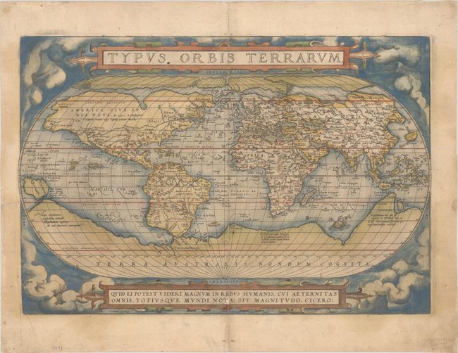
Auction 185, Lot 2
Subject: World
Ortelius, Abraham
Typus Orbis Terrarum, 1571
Size: 19.5 x 13.4 inches (49.5 x 34 cm)
Estimate: $5,500 - $6,500
Ortelius' Famous World Map - First Plate in Full Contemporary Color
Sold for: $4,500
Closed on 11/17/2021
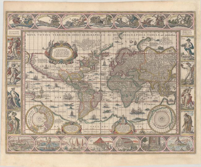
Auction 185, Lot 4
Subject: World
Blaeu, Willem
Nova Totius Terrarum Orbis Geographica ac Hydrographica Tabula, 1643
Size: 21.4 x 16.1 inches (54.4 x 40.9 cm)
Estimate: $12,000 - $15,000
Blaeu's Magnificent Carte-a-Figures World Map
Sold for: $9,000
Closed on 11/17/2021
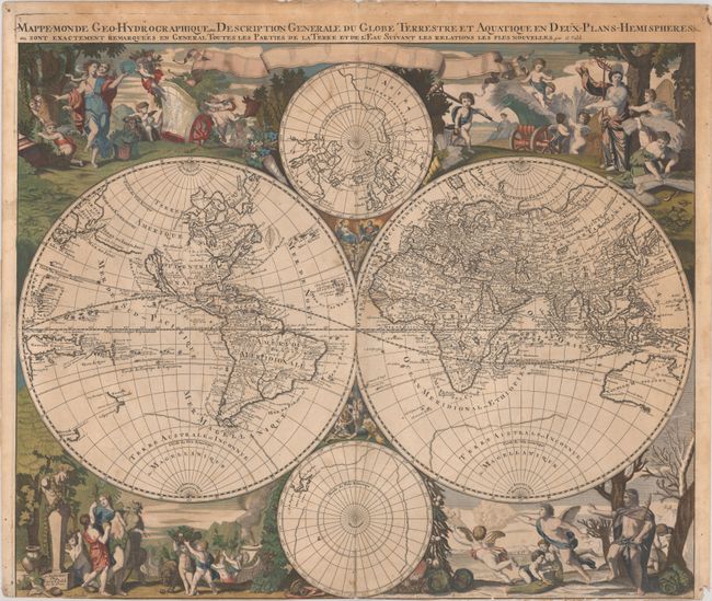
Auction 185, Lot 7
Subject: World
Valck, Gerard
Mappe-Monde Geo-Hydrographique, ou Description Generale du Globe Terrestre et Aquatique en Deux-Plans-Hemispheres..., 1686
Size: 23 x 18.9 inches (58.4 x 48 cm)
Estimate: $3,000 - $3,750
Scarce Baroque-Style Double-Hemisphere Map Depicting the Four Seasons
Sold for: $2,000
Closed on 11/17/2021
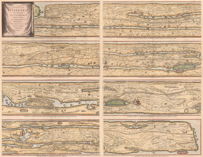
Auction 185, Lot 36
Subject: Ancient World
Jansson, Jan
[On 4 Sheets] Tabula Itineraria ex Illustri Peutingerorum Bibliotheca quae Augustae Vindelicorum Beneficio Marci Velseri Septem-Viri Augustani in Lucem Edita, 1660
Size: 20 x 15.5 inches (50.8 x 39.4 cm)
Estimate: $2,300 - $2,750
Famous Peutinger Table
Sold for: $3,500
Closed on 11/17/2021
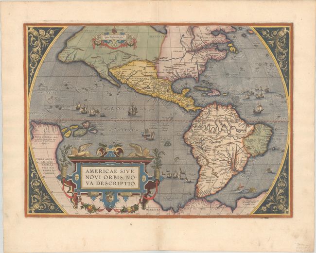
Auction 185, Lot 65
Subject: Western Hemisphere - America
Ortelius, Abraham
Americae sive Novi Orbis, Nova Descriptio, 1587
Size: 19 x 13.9 inches (48.3 x 35.3 cm)
Estimate: $5,500 - $6,500
Ortelius' Influential Map of the New World
Sold for: $4,000
Closed on 11/17/2021
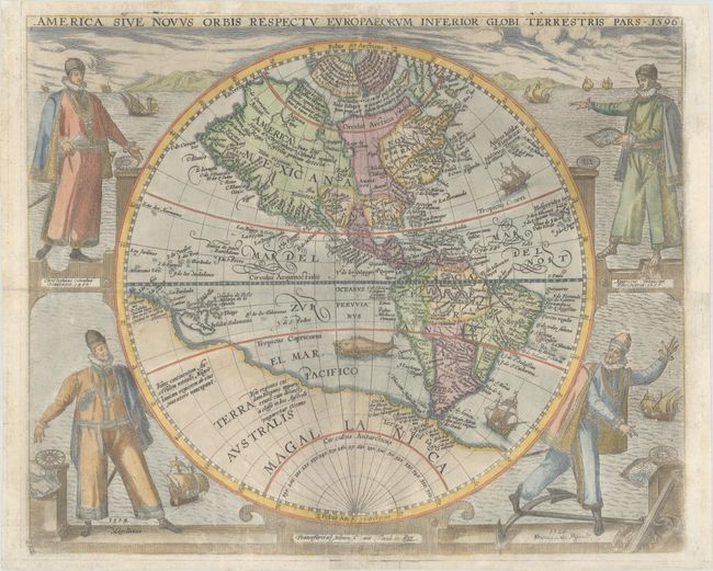
Auction 185, Lot 66
Subject: Western Hemisphere - America
Bry, Theodore de
America sive Novus Orbis Respectu Europaeorum Inferior Globi Terrestris Pars, 1596
Size: 15.7 x 12.8 inches (39.9 x 32.5 cm)
Estimate: $7,000 - $8,500
De Bry's Rare Map of the New World Featuring Explorers
Unsold
Closed on 11/17/2021
Auction 185, Lot 68
Subject: Western Hemisphere - America
Bertius/Tavernier
Carte de l'Amerique Corrigee et Augmentee; Dessus Toutes les Aultres cy Devant Faictes, 1661
Size: 14.4 x 10.8 inches (36.6 x 27.4 cm)
Estimate: $1,400 - $1,700
Rare Derivative of Hondius' Influential Map
Unsold
Closed on 11/17/2021
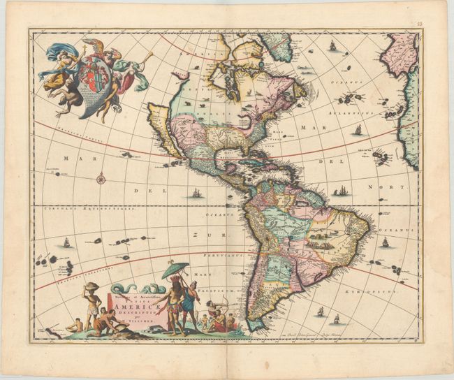
Auction 185, Lot 70
Subject: Western Hemisphere - America
Visscher, Nicolas
Novissima et Accuratissima Totius Americae Descriptio, 1677
Size: 21.4 x 17.1 inches (54.4 x 43.4 cm)
Estimate: $1,600 - $1,900
Visscher's Classic Map of the Americas with the Island of California in Full Contemporary Color
Sold for: $1,200
Closed on 11/17/2021
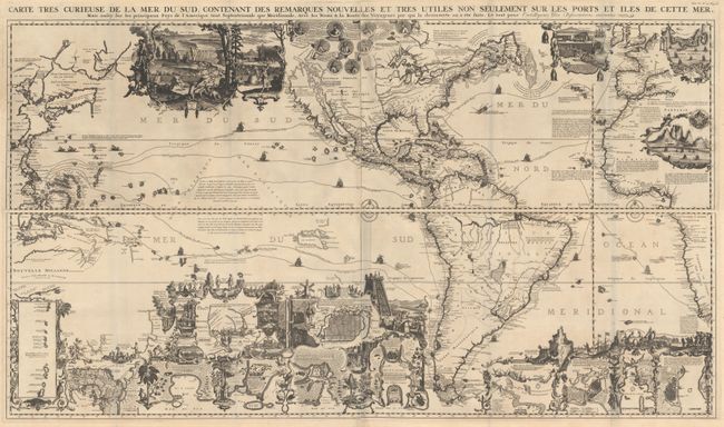
Auction 185, Lot 72
Subject: Western Hemisphere - America
Chatelain, Henry Abraham
[On 4 Sheets] Carte Tres Curieuse de la Mer du Sud, Contenant des Remarques Nouvelles et Tres Utiles non Seulement sur les Ports et Iles de Cette Mer..., 1719
Size: 56 x 16.3 inches (142.2 x 41.4 cm)
Estimate: $13,000 - $16,000
Spectacular Wall Map Celebrating the New World
Sold for: $9,500
Closed on 11/17/2021
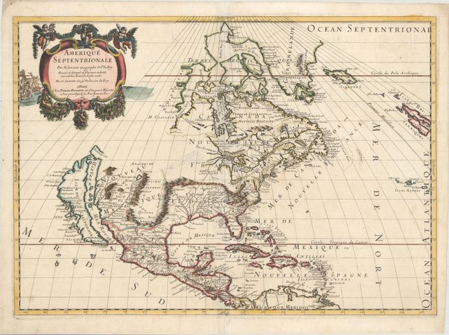
Auction 185, Lot 87
Subject: Colonial North America
Sanson/Mariette
Amerique Septentrionale, 1669
Size: 22 x 15.7 inches (55.9 x 39.9 cm)
Estimate: $2,000 - $2,300
Important Map for Great Lakes Collectors
Sold for: $1,700
Closed on 11/17/2021
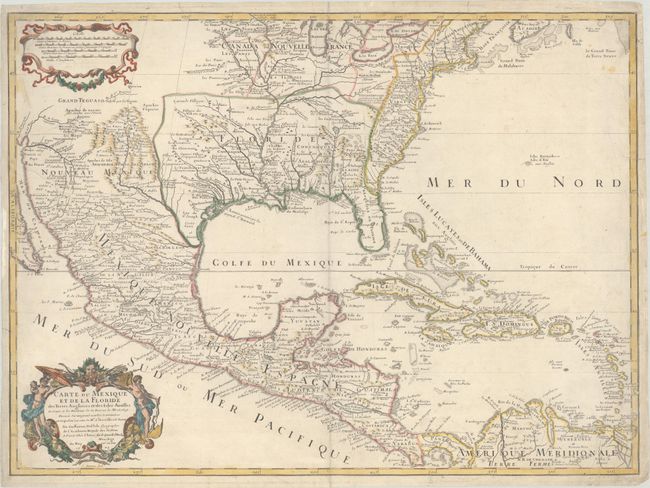
Auction 185, Lot 109
Subject: Colonial Eastern North America & Caribbean
Delisle, Guillaume
Carte du Mexique et de la Floride des Terres Angloises et des Isles Antilles du Cours et des Environs de la Riviere de Mississipi..., 1703
Size: 25.4 x 18.7 inches (64.5 x 47.5 cm)
Estimate: $2,750 - $3,500
Landmark in American Cartography - First Printed Map to Accurately Depict the Mouth of the Mississippi River
Unsold
Closed on 11/17/2021
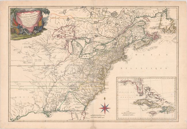
Auction 185, Lot 111
Subject: Colonial Eastern North America & Caribbean
Esnauts & Rapilly
Carte Detaillee des Possessions Angloises dans l'Amerique Septentrionale…, 1777
Size: 29.8 x 20.5 inches (75.7 x 52.1 cm)
Estimate: $4,500 - $5,500
Rare First State of French Map Showing Theater of War During American Revolution
Unsold
Closed on 11/17/2021
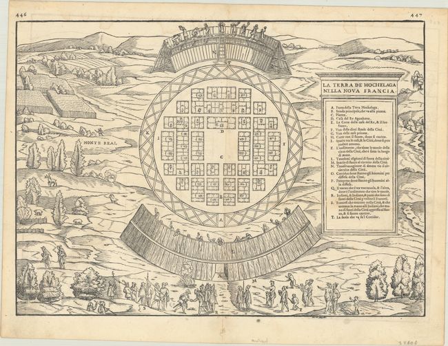
Auction 185, Lot 121
Subject: Montreal, Canada
Gastaldi/Ramusio
La Terra de Hochelaga nella Nova Francia, 1556
Size: 14.6 x 10.6 inches (37.1 x 26.9 cm)
Estimate: $2,200 - $2,500
The First Published Plan of a Settlement in North America
Sold for: $2,750
Closed on 11/17/2021
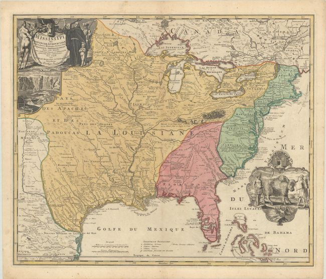
Auction 185, Lot 126
Subject: Colonial Eastern United States & Canada
Homann, Johann Baptist
Amplissimae Regionis Mississipi seu Provinciae Ludovicianae a R.P. Ludovico Hennepin Francisc Miss. in America Septentrionali Anno 1687..., 1730
Size: 22.9 x 19.3 inches (58.2 x 49 cm)
Estimate: $2,000 - $2,300
Striking Map of Colonial America with Bison Vignette
Sold for: $1,500
Closed on 11/17/2021
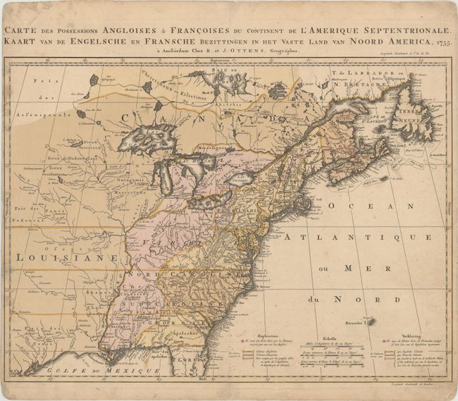
Auction 185, Lot 129
Subject: Colonial Eastern United States & Canada
Ottens, Reiner and Joshua
Carte des Possessions Angloises & Francoises du Continent de l'Amerique Septentrionale / Kaart van de Engelsche en Fransche Bezittingen in het Vaste Land van Noord America, 1755
Size: 22.4 x 16.3 inches (56.9 x 41.4 cm)
Estimate: $1,500 - $1,800
Dutch Version of an Important Map Showing Territorial Claims at the Outset of the French and Indian War
Unsold
Closed on 11/17/2021
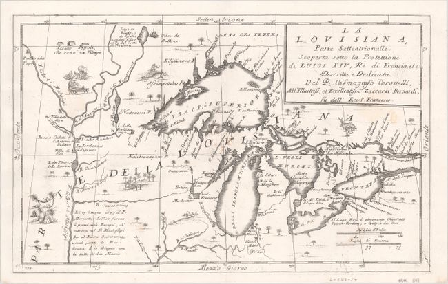
Auction 185, Lot 150
Subject: Colonial Central United States & Canada, Great Lakes
Coronelli, Vincenzo Maria
La Louisiana, Parte Settentrionalle, Scoperta Sotto la Protettione di Luigi XIV, Re di Francia, Etc. , 1696
Size: 16.4 x 10.1 inches (41.7 x 25.7 cm)
Estimate: $2,750 - $3,500
Coronelli's Important Map of the Great Lakes & Upper Mississippi River Valley
Sold for: $4,500
Closed on 11/17/2021
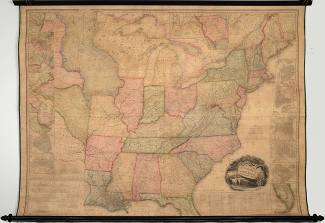
Auction 185, Lot 155
Subject: United States
Tanner, Henry Schenck
United States of America, 1829
Size: 59.8 x 45.4 inches (151.9 x 115.3 cm)
Estimate: $7,000 - $8,500
First Edition of Tanner's Important Map of the United States
Sold for: $7,000
Closed on 11/17/2021
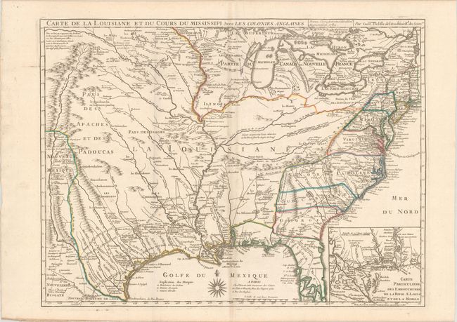
Auction 185, Lot 175
Subject: Colonial Eastern United States, Louisiana Territory
Delisle/Dezauche
Carte de la Louisiane et du Cours du Mississipi avec les Colonies Anglaises, 1782
Size: 25.6 x 19.2 inches (65 x 48.8 cm)
Estimate: $1,400 - $1,700
Dezauche Edition of Delisle's Influential Map of the Louisiana Territory
Sold for: $850
Closed on 11/17/2021
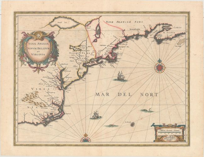
Auction 185, Lot 195
Subject: Colonial New England & Mid-Atlantic United States
Jansson, Jan
Nova Anglia Novum Belgium et Virginia, 1639
Size: 19.9 x 15.3 inches (50.5 x 38.9 cm)
Estimate: $1,200 - $1,500
Jansson's Influential Map of the East Coast
Sold for: $900
Closed on 11/17/2021
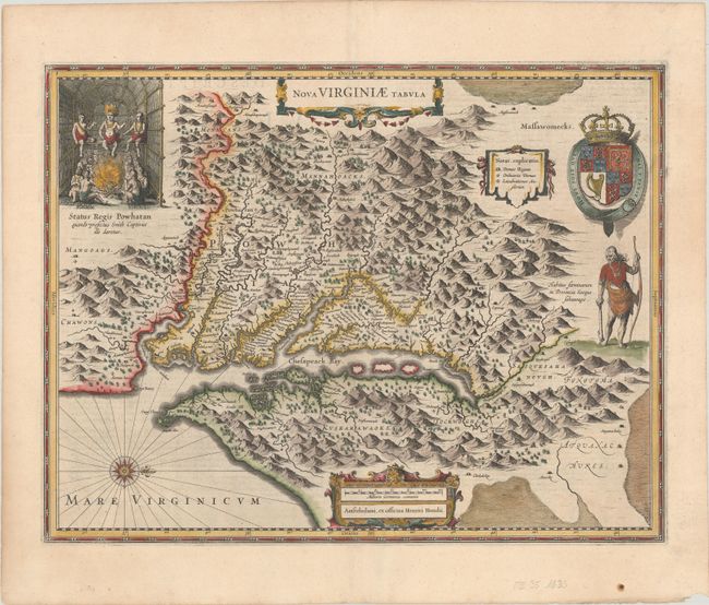
Auction 185, Lot 202
Subject: Colonial Mid-Atlantic United States
Hondius, Henricus
Nova Virginiae Tabula, 1633
Size: 19.6 x 15.1 inches (49.8 x 38.4 cm)
Estimate: $2,000 - $2,300
One of the Most Important 17th Century Maps of the Chesapeake Bay
Unsold
Closed on 11/17/2021
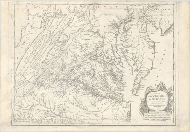
Auction 185, Lot 204
Subject: Colonial Mid-Atlantic United States
Robert de Vaugondy
Carte de la Virginie et du Maryland Dressee sur la Grande Carte Angloise de Mrs. Josue Fry et Pierre Jefferson, 1755
Size: 25.1 x 19 inches (63.8 x 48.3 cm)
Estimate: $1,200 - $1,500
An Essential Map of Virginia and Maryland
Sold for: $900
Closed on 11/17/2021
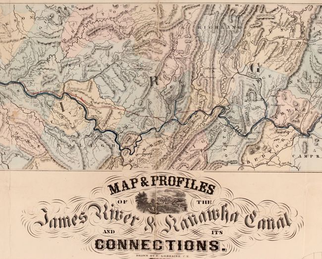
Auction 185, Lot 211
Subject: Mid-Atlantic United States, James River
Map & Profiles of the James River & Kanawha Canal and its Connections, 1857
Size: 58 x 24.5 inches (147.3 x 62.2 cm)
Estimate: $2,400 - $3,000
Map of the Proposed James River and Kanawha Canal
Unsold
Closed on 11/17/2021
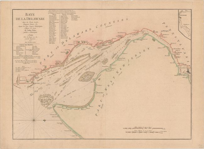
Auction 185, Lot 212
Subject: Delaware Bay
Le Rouge, George Louis
Baye de la Delaware avec les Ports, Sondes, Dangers, Bancs, &c. Depuis les Caps Jusqu'a Philadelphie d'Apres la Carte de Joshua Fisher..., 1777
Size: 25.1 x 18.4 inches (63.8 x 46.7 cm)
Estimate: $1,800 - $2,100
The Most Accurate Chart of Delaware Bay in the 18th Century - Rare First State
Sold for: $1,300
Closed on 11/17/2021
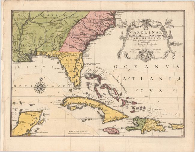
Auction 185, Lot 215
Subject: Colonial Southeast United States, Bahamas & Greater Antilles
Seligmann, Johann Michael
Carolinae Floridae nec non Insularum Bahamensium cum Partibus Adjacendibus Delineatio ad Exemplar Londinense in Lucem Edita, 1755
Size: 23.1 x 16.9 inches (58.7 x 42.9 cm)
Estimate: $4,000 - $4,750
German Edition of Catesby's Scarce and Important Map of the Southeastern United States
Sold for: $3,000
Closed on 11/17/2021
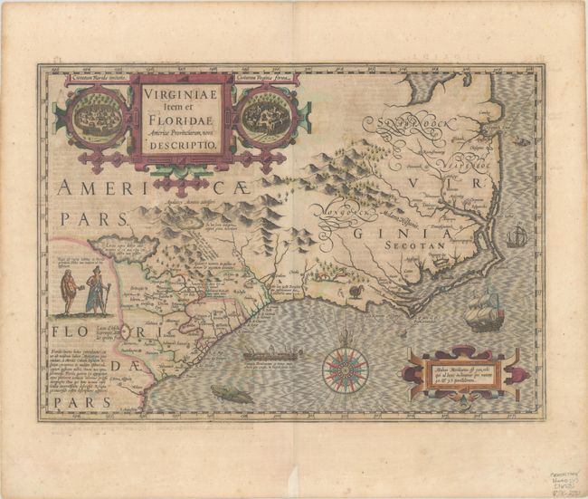
Auction 185, Lot 216
Subject: Colonial Southeast United States
Hondius, Jodocus
Virginiae Item et Floridae Americae Provinciarum, Nova Descriptio, 1634
Size: 19.1 x 13.5 inches (48.5 x 34.3 cm)
Estimate: $1,600 - $1,900
A Seminal Map of the Southeast and Early American Cartography - Full Contemporary Color
Sold for: $1,600
Closed on 11/17/2021
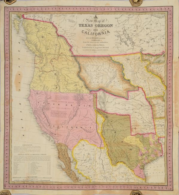
Auction 185, Lot 238
Subject: Western United States, Texas
Mitchell, Samuel Augustus
[Map in Book] A New Map of Texas Oregon and California with the Regions Adjoining. Compiled from the Most Recent Authorities [in] A General View of the United States..., 1846
Size: 20.7 x 22.3 inches (52.6 x 56.6 cm)
Estimate: $9,500 - $12,000
One of the Most Influential Maps of Westward Expansion
Sold for: $7,000
Closed on 11/17/2021
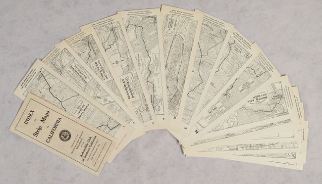
Auction 185, Lot 256
Subject: California
Automobile Club of Southern California
[Lot of 145 - Automobile Club of Southern California Strip Maps & Index Map], 1920
Size: 2.9 x 8.6 inches (7.4 x 21.8 cm)
Estimate: $600 - $800
Complete Run of ACSC Strip Maps
Sold for: $550
Closed on 11/17/2021
Auction 185, Lot 314
Subject: New York
Smith, William
The History of the Province of New-York, from the First Discovery to the Year M.DCC.XXXII..., 1757
Size: 8.5 x 10.5 inches (21.6 x 26.7 cm)
Estimate: $2,000 - $2,400
A Foundation Piece for New York Collectors
Sold for: $1,200
Closed on 11/17/2021
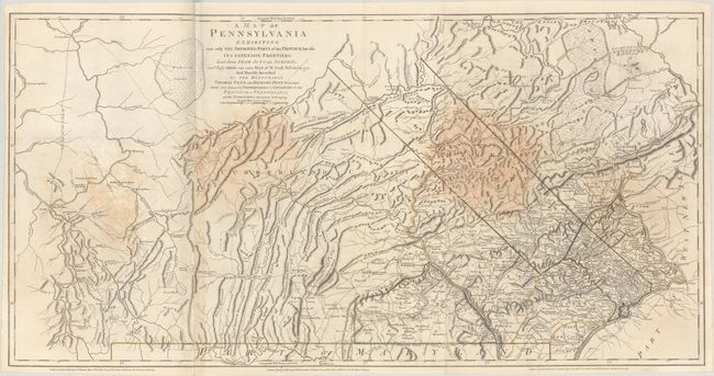
Auction 185, Lot 326
Subject: Pennsylvania, Revolutionary War
Sayer & Bennett
A Map of Pennsylvania Exhibiting Not Only the Improved Parts of That Province, but Also Its Extensive Frontiers: Laid Down from Actual Surveys..., 1775
Size: 53 x 26.9 inches (134.6 x 68.3 cm)
Estimate: $2,750 - $3,500
English Revision of William Scull’s Map of Pennsylvania
Sold for: $1,400
Closed on 11/17/2021
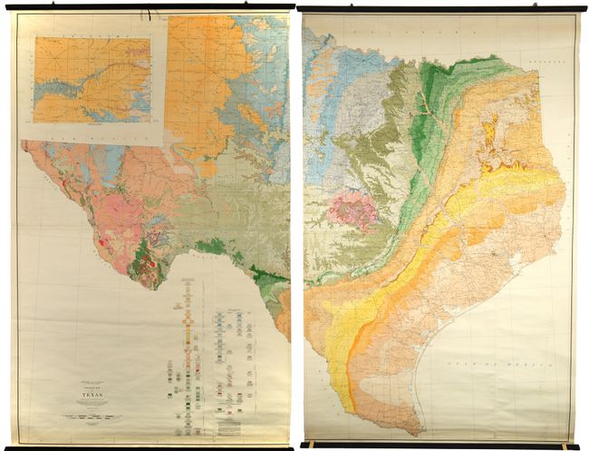
Auction 185, Lot 330
Subject: Texas, Geology
U.S. Geological Survey (USGS)
[2 Wall Maps on 4 Sheets] Geologic Map of Texas, 1937
Size: 51 x 80.5 inches (129.5 x 204.5 cm)
Estimate: $1,500 - $2,000
A Texas-Sized Geological Map
Sold for: $1,000
Closed on 11/17/2021
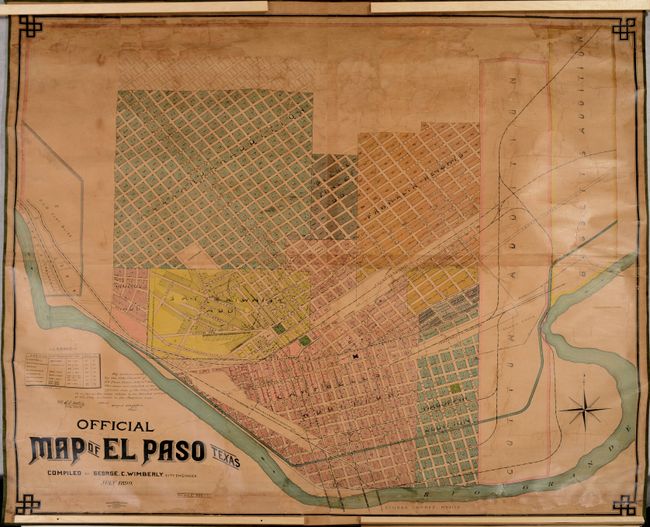
Auction 185, Lot 335
Subject: El Paso, Texas
August Gast Bank Note & Litho. Co.
Official Map of El Paso Texas, 1899
Size: 54.8 x 51 inches (139.2 x 129.5 cm)
Estimate: $3,000 - $3,750
An Early and Rare Wall Map of El Paso
Sold for: $3,750
Closed on 11/17/2021
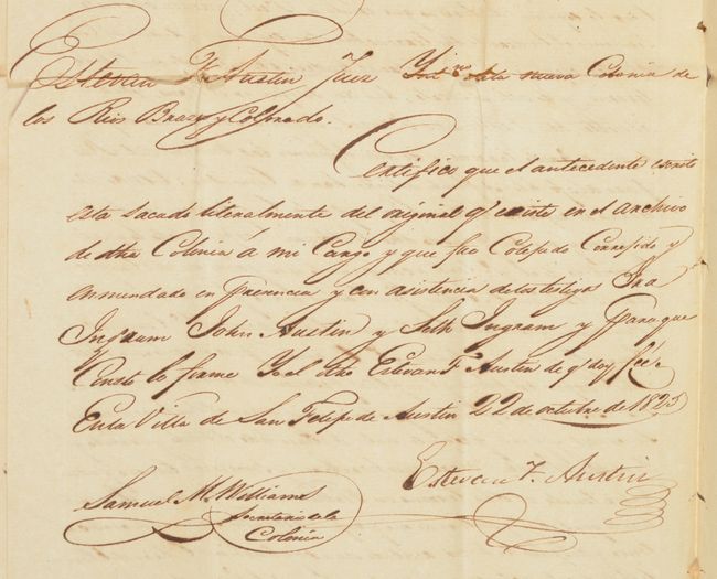
Auction 185, Lot 336
Subject: Austin's Colony
[2 Private Land Sales in Austin's Colony - Each Signed by Stephen F. Austin], 1825
Size: 7.8 x 12.5 inches (19.8 x 31.8 cm)
Estimate: $12,000 - $15,000
Two of the Earliest Examples of Private Land Sales in Austin's Colony
Sold for: $18,000
Closed on 11/17/2021
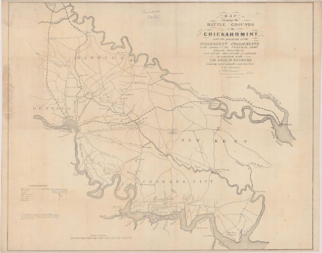
Auction 185, Lot 343
Subject: Eastern Virginia, Civil War
Sheppard, E.
Map Showing the Battle Grounds of the Chickahominy, and the Positions of the Subsequent Engagements in the Retreat of the Federal Army Towards James River and All the Other Points of Interest in Connection with the Siege of Richmond..., 1862
Size: 20.1 x 16.3 inches (51.1 x 41.4 cm)
Estimate: $2,200 - $2,500
Rare Confederate Battle Map Published in Richmond
Sold for: $1,100
Closed on 11/17/2021
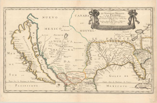
Auction 185, Lot 349
Subject: Colonial United States & Mexico
Sanson, Nicolas
Le Nouveau Mexique, et la Floride…, 1656
Size: 21.5 x 12.3 inches (54.6 x 31.2 cm)
Estimate: $5,500 - $7,000
First Edition of Sanson's Important Map of the American Southwest
Sold for: $4,000
Closed on 11/17/2021
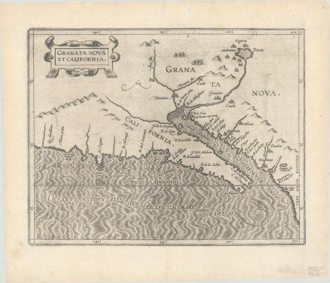
Auction 185, Lot 356
Subject: Southwestern United States & Mexico
Wytfliet, Cornelis
Granata Nova et California, 1597
Size: 11.5 x 9 inches (29.2 x 22.9 cm)
Estimate: $2,750 - $3,500
First Printed Map to Focus on California and the Southwest
Sold for: $2,000
Closed on 11/17/2021
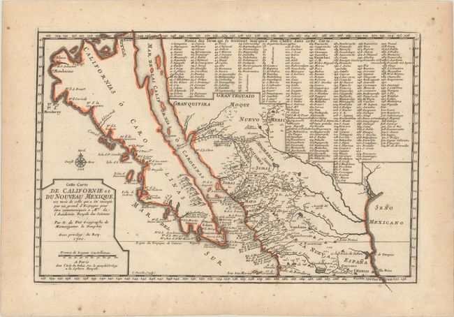
Auction 185, Lot 357
Subject: Southwestern United States & Mexico, California
Fer, Nicolas de
Cette Carte de Californie et du Nouveau Mexique…, 1700
Size: 13.3 x 8.8 inches (33.8 x 22.4 cm)
Estimate: $950 - $1,200
De Fer's Important Map of the Island of California
Sold for: $1,200
Closed on 11/17/2021
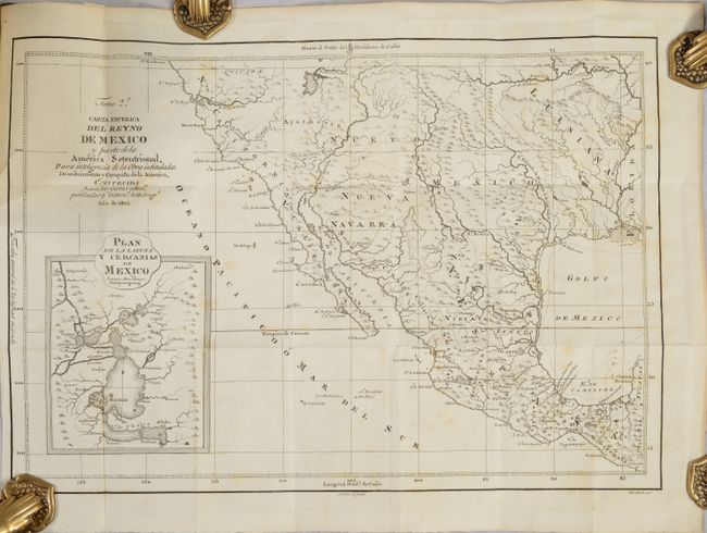
Auction 185, Lot 358
Subject: Southwestern United States & Mexico
[Map in Book] Carta Esferica del Reyno de Mexico y Parte de la America Setentrional... [in] Descubrimiento y Conquista de la America, o Compendio de la Historia General del Nuevo Mundo ... Tomo II, 1803
Size: 18.1 x 12.5 inches (46 x 31.8 cm)
Estimate: $1,800 - $2,200
A Scarce Spanish Map of the Southwest
Sold for: $3,250
Closed on 11/17/2021
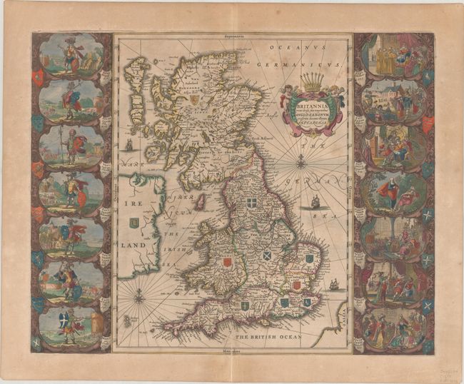
Auction 185, Lot 439
Subject: Britain
Jansson, Jan
Britannia Prout Divisa Suit Temporibus Anglo-Saxonum, Praesertim Durante Illorum Heptarchia, 1646
Size: 20.8 x 16.5 inches (52.8 x 41.9 cm)
Estimate: $1,500 - $1,800
Jansson's Splendid Heptarchy Map in Full Contemporary Color
Sold for: $1,000
Closed on 11/17/2021
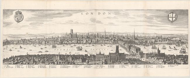
Auction 185, Lot 448
Subject: London, England
Merian, Matthaus
London, 1629
Size: 27.7 x 8.3 inches (70.4 x 21.1 cm)
Estimate: $2,750 - $3,500
Superb Panoramic View of London
Sold for: $3,000
Closed on 11/17/2021
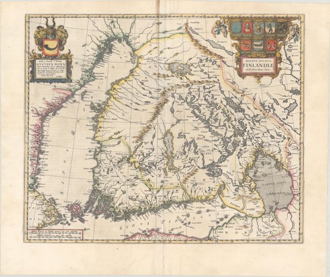
Auction 185, Lot 471
Subject: Finland
Blaeu, Johannes
Magnus Ducatus Finlandiae Auct. Andrea Buraeo Sueco, 1659
Size: 20.6 x 17 inches (52.3 x 43.2 cm)
Estimate: $1,300 - $1,600
The First Separately Published Map of Finland
Unsold
Closed on 11/17/2021
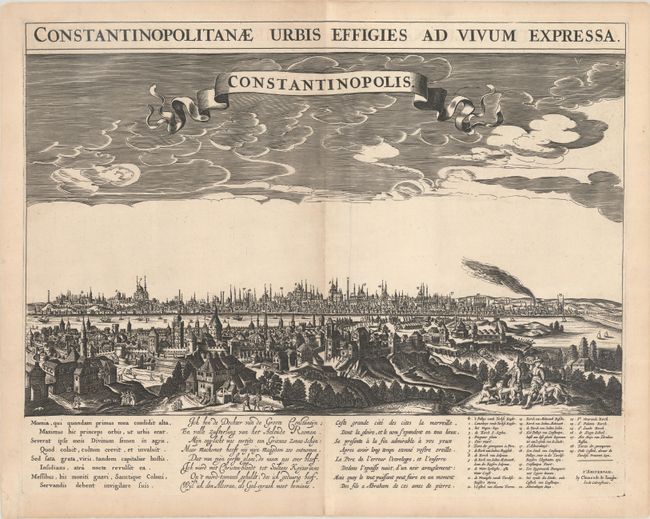
Auction 185, Lot 623
Subject: Istanbul, Turkey
Jonghe, Clement de
Constantinopolis, 1675
Size: 20 x 13.2 inches (50.8 x 33.5 cm)
Estimate: $2,500 - $3,250
Superb, Rare View of Istanbul with Tri-Lingual Verses
Sold for: $1,500
Closed on 11/17/2021
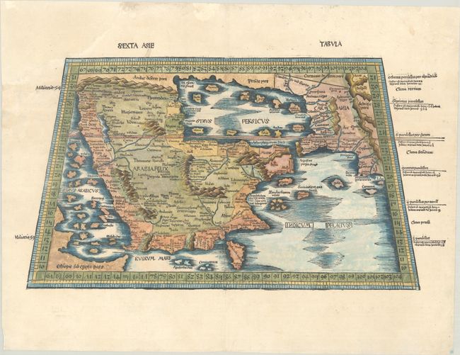
Auction 185, Lot 640
Subject: Arabia
Ptolemy/Waldseemuller
Sexta Asie Tabula, 1513
Size: 21.9 x 11.8 inches (55.6 x 30 cm)
Estimate: $3,750 - $4,750
Waldseemuller's Rare Ptolemaic Map of Arabia
Sold for: $2,750
Closed on 11/17/2021
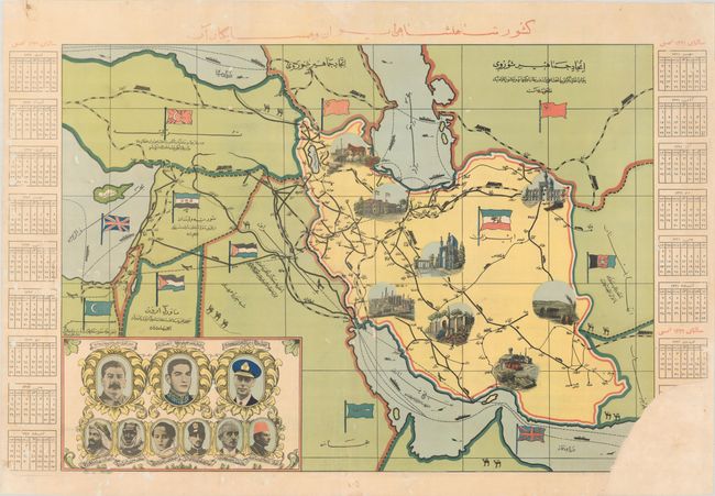
Auction 185, Lot 646
Subject: Iran, World War II
[World War II Propaganda Map - The Iranian Empire and its Neighbors], 1942
Size: 27 x 19.4 inches (68.6 x 49.3 cm)
Estimate: $900 - $1,200
Rare Farsi Propaganda Map from World War II
Sold for: $450
Closed on 11/17/2021
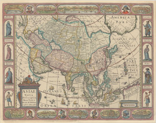
Auction 185, Lot 653
Subject: Asia
Visscher, Nicolas
Asiae Nova Descriptio, 1652
Size: 22.3 x 17.3 inches (56.6 x 43.9 cm)
Estimate: $2,750 - $3,500
Rare Four-Paneled Carte-a-Figures Map of Asia
Sold for: $1,800
Closed on 11/17/2021
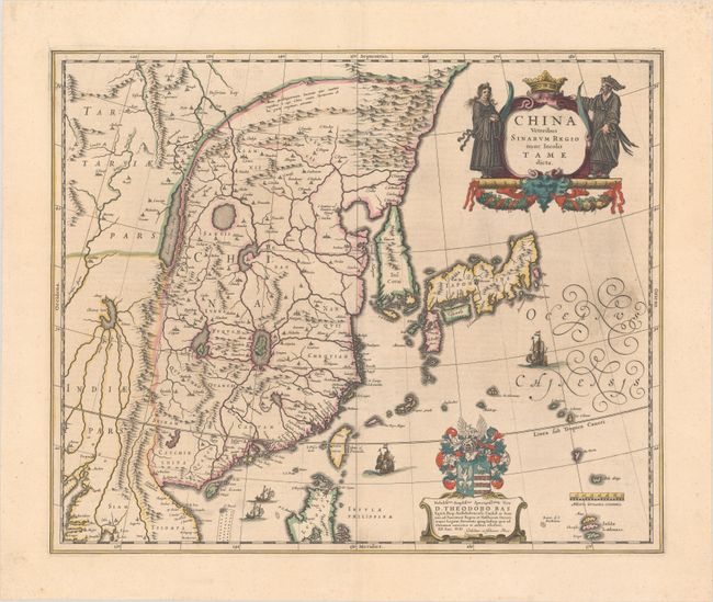
Auction 185, Lot 665
Subject: China, Korea & Japan
Blaeu, (Family)
China Veteribus Sinarum Regio nunc Incolis Tame Dicta, 1641
Size: 19.8 x 16.2 inches (50.3 x 41.1 cm)
Estimate: $1,600 - $1,900
Blaeu's Map of China Featuring Fictitious Lakes and Rivers in Full Contemporary Color
Unsold
Closed on 11/17/2021
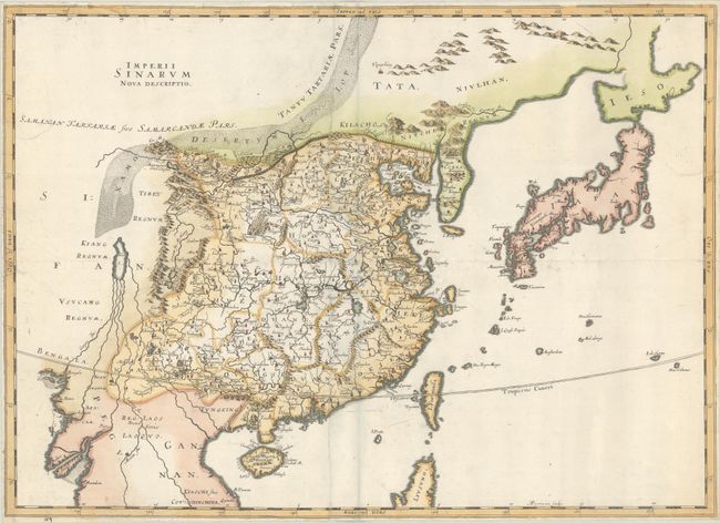
Auction 185, Lot 666
Subject: China, Korea & Japan
Thevenot, Melchisedech
Imperii Sinarum Nova Descriptio, 1672
Size: 24.9 x 18 inches (63.2 x 45.7 cm)
Estimate: $2,000 - $2,400
Rare Map of China Based on Blaeu
Sold for: $1,500
Closed on 11/17/2021
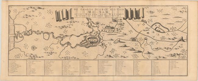
Auction 185, Lot 671
Subject: Chao Phraya River, Thailand
Valentyn, Francois
De Groote Siamse Rievier Me-Nam ofte Moeder der Wateren in Haren Loop met de in Vallende Spruyten Verbeeld, 1726
Size: 29.4 x 11.7 inches (74.7 x 29.7 cm)
Estimate: $1,900 - $2,200
Rare Map of Thailand Featuring Bangkok
Sold for: $2,200
Closed on 11/17/2021
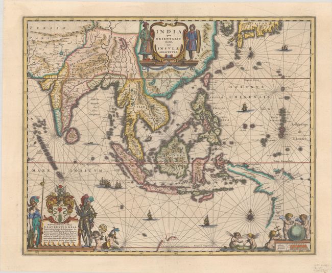
Auction 185, Lot 681
Subject: Southern & Southeast Asia
Blaeu, Willem
India quae Orientalis Dicitur, et Insulae Adiacentes, 1641
Size: 19.8 x 16.2 inches (50.3 x 41.1 cm)
Estimate: $1,600 - $1,900
The First Popular Map to Show European Discoveries in Australia
Sold for: $1,500
Closed on 11/17/2021
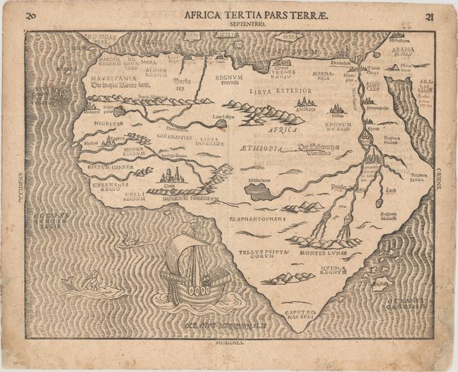
Auction 185, Lot 689
Subject: Africa
Bunting, Heinrich
Africa Tertia Pars Terrae, 1589
Size: 13.5 x 10.2 inches (34.3 x 25.9 cm)
Estimate: $950 - $1,200
Bunting's Unique Map of Africa
Unsold
Closed on 11/17/2021
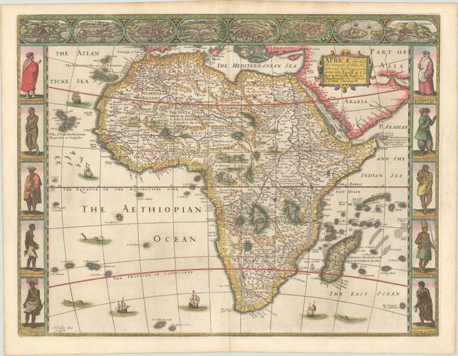
Auction 185, Lot 692
Subject: Africa
Speed, John
Africae, Described, the Manners of Their Habits, and Buildinge: Newly Done into English, 1676
Size: 20.3 x 15.5 inches (51.6 x 39.4 cm)
Estimate: $4,000 - $5,000
Speed's Carte-a-Figures Map of Africa
Sold for: $3,000
Closed on 11/17/2021
58 lots
Page 1 of 2