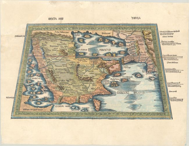
Subject: Arabia
Period: 1513 (circa)
Publication: Claudii Ptolemei viri Alexandrini ... Geographia...
Color: Hand Color
Size:
21.9 x 11.8 inches
55.6 x 30 cm
Claudius Ptolemy was a mathematician, astronomer and geographer who worked in Alexandria, then a part of the Roman Empire, in the 2nd century AD. One of the most learned and influential men of his time, his theories dominated both astronomy and geography for nearly 1500 years. His writings were kept alive by Arabic scholars during the Middle Ages and reemerged in Europe during the Renaissance. The birth of printing led to wide dissemination of his great works on astronomy and geography. There were a number of editions of his Geographia beginning in 1477. These early editions contained maps based on his original writings, known as Ptolemaic maps. As geographic knowledge increased with the explorations of Columbus, Magellan, Cabot and others, maps of the New World were added, and maps of the Old World were revised. Ptolemy's Geographia continued to be revised and published by some of the most important cartographers including Martin Waldseemuller, Sebastian Munster, Giacomo Gastaldi, Jodocus Hondius, and Gerard Mercator (whose last edition was published in 1730).
This rare Ptolemaic map of Arabia appeared in the 1513 and 1520 editions of Geographia. Waldseemüller's Geographia was the first to supplement the traditional Ptolemaic maps with 20 "modern" ones, creating the first modern atlas and representing a landmark in the history of cartography. This modern map of Arabia shows numerous islands in the Red Sea and the Persian Gulf, with several large mountain ranges and numerous place names in Arabia. Both the width of the southern part of Arabia and the size and shape of the Arabian Gulf are both oversized. This overall form of the peninsula, labeled here Arabia Felix, was hugely influential, and served as a standard for European maps of the region for many years.
References: Ankary #4; Mickwitz & Miekkavaara #205-21; Tibbets #13.
Condition: B
A nice impression on paper with a small fleur-de-lis watermark. There are a number of small worm holes and worm tracks in the image that have been professionally repaired, with a very small amount of the image replaced in facsimile. Additional worm holes in the blank margins and large chips in the top corners of the sheet have also been professionally repaired. Despite the repairs, the map presents itself very well.