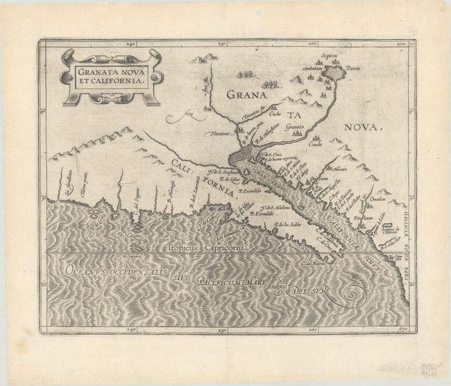
Subject: Southwestern United States & Mexico
Period: 1597 (circa)
Publication: Descriptionis Ptolemaicae Augmentum
Color: Black & White
Size:
11.5 x 9 inches
29.2 x 22.9 cm
This is the first printed map to focus on California and the American Southwest, from the first atlas devoted entirely to maps of the Americas. Wytfliet's work was referred to as a continuation of Ptolemy, despite the fact that there was little connection with Ptolemy except for his name on the title page. Wytfliet compiled his atlas using multiple published sources, including Ramusio, Hakluyt and De Bry. The basis of this map is taken from Petrus Plancius' influential world map of 1592, including the error in naming the Tropicus Capricorni instead of the correct Tropic of Cancer. The most notable feature of the map is the location of the legendary seven cities of Cibola, Septem civitatum Patria, shown surrounding a lake, out of which flows a river that empties into the Mar Vermeio or Gulf of California. The information on the map is from Spanish sources including the narrative of Fray Marco de Niza in 1539 and the account of a rescue party led by Antonio de Espego in 1582. A very attractive map with a strapwork title cartouche and fully engraved seas.
References: Burden #106; Heckrotte #7; Wagner #188; Wheat (TWM) #29.
Condition: A
A dark impression on a bright sheet with a small fleur-de-lis watermark, a soft crease at top right, and a small hole and tiny centerfold separation in the top blank margin