Subject: Africa
Period: 1589 (circa)
Publication: Itinerarium Sacrae Scripturae
Color: Black & White
Size:
13.5 x 10.2 inches
34.3 x 25.9 cm
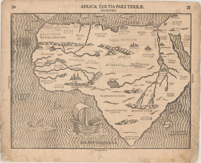
A very rare woodcut map of the continent with an unusual shape, tapering to a point in the south. Like Bunting's other, more allegorical maps, this map of Africa is unique. The interior is presented in the traditional manner with the Nile rising from twin lakes in the Montes Lunae. However, Bunting introduces a third, even larger lake, Nidilis lacus, in central Africa, and a small lake to the east as additional sources for the Nile. Meroe, the mythical tombs of the Nubian Kings, are located on a large island in the Nile River. Priester Johans Land, mythical kingdom of the Christian king Prester John, is located at the juncture of the Blue and White Nile. Der weissen Morenland (the White Moors) are shown in northwest Africa, and Der Schwartzen Morenland (the Black Moors) are in the central region. The island of Zaphala with a group of other small islands occupy roughly the position of Madagascar, and probably refers to the region from which King Solomon supposedly acquired the gold and silver for his temple. The surrounding seas are engraved in narrow wavy lines and include a sailing ship, merman and a sea bird. Bunting's popular theological commentary was first published in 1581, but did not include this separate map of Africa until 1589. This is the first variant with the placement of Alcayr (Cairo) on the east bank of the Nile, and Memphis on the west bank. German text on verso.
References: Betz #24.1; Norwich #17; Tooley (MCC-29) #141.
Condition: B+
Light toning and soiling that is more pronounced in the blank margins, with professional repairs to some chips and tears along the edges of the sheet, with a couple of tears entering less than 1/2" into the image.


