Subject: Pennsylvania, Revolutionary War
Period: 1775 (dated)
Publication:
Color: Hand Color
Size:
53 x 26.9 inches
134.6 x 68.3 cm
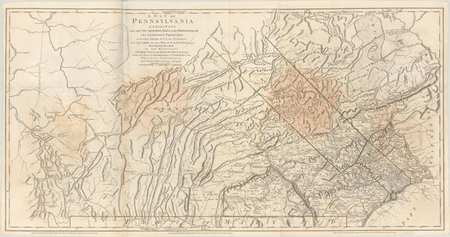
This is Sayer & Bennett's important three-sheet map of Pennsylvania. The map is based on the 1770 landmark map of the province by William Scull, which was culled heavily from his grandfather Nicholas Scull's early map of the region, originally published in 1759. Sayer and Bennett published this revised edition in both Thomas Jefferys' American Atlas and William Faden's North American Atlas. As the title states, the map shows both the developed eastern side of Pennsylvania and the western frontier as far west as Fort Pitt formerly Fort Duquesne (Pittsburgh) on the Ohio River. The Mason-Dixon line, surveyed just a few years before the publication of William Scull's original map, is delineated here. There is excellent detail of the region's mountains and hills, with many ranges identified. The easternmost counties of the province are dense with place names, while Cumberland County has relatively little settlement. Early counties, rivers, roads, forts, creeks, mills, mines, churches, and more are also located. There is a Great Swamp in Northampton County, just below The Endless Mountains while a large Buffaloe Swamp is delineated on the westernmost sheet.
References: Phillips (Atlases) #1212-16; Phillips (Maps) p. 675; Ristow, pp. 52-53.
Condition: B
A nice impression with contemporary outline color on sturdy, bright sheets with minor offsetting and several large dampstains.