Showing Featured Lots(remove filter)
Showing results for:Auction 180
Catalog Archive
46 lots
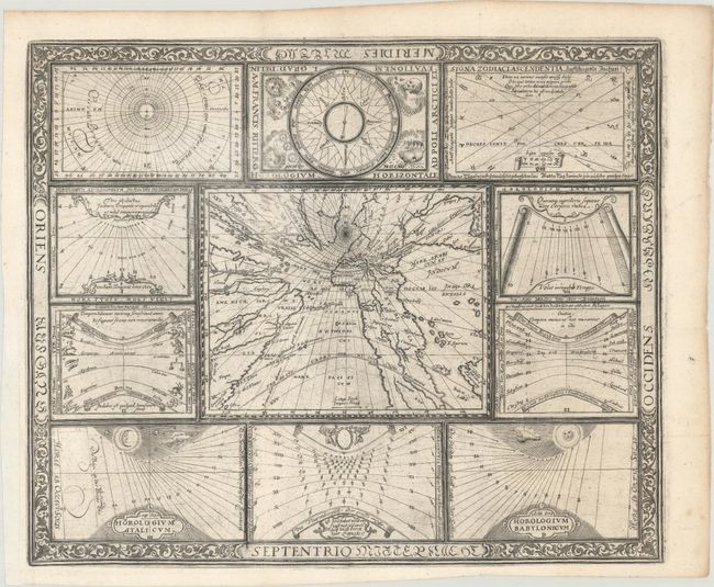
Auction 180, Lot 3
Subject: World
Ritter, Franz
[Untitled - World and Horological Diagrams], 1607
Size: 13.4 x 11 inches (34 x 27.9 cm)
Estimate: $3,000 - $3,750
Ritter's Unusual Sun-Dial World Map - First State
Sold for: $1,800
Closed on 11/18/2020
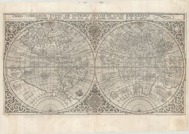
Auction 180, Lot 4
Subject: World
Plancius, Petrus
Orbis Terrarum Typus de Integro Multis in Locis Emendatus, 1647
Size: 20.1 x 11.3 inches (51.1 x 28.7 cm)
Estimate: $1,900 - $2,200
Plancius' World Map Surrounded by Elegant Strapwork
Sold for: $1,400
Closed on 11/18/2020
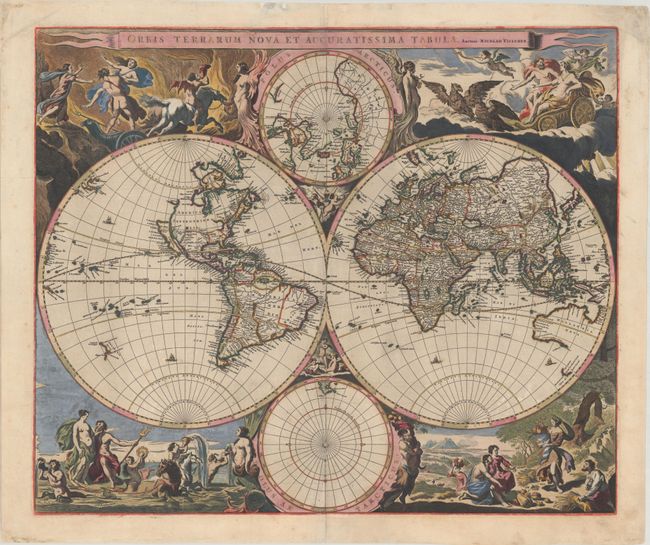
Auction 180, Lot 5
Subject: World
Visscher, Nicolas
Orbis Terrarum Nova et Accuratissima Tabula, 1658
Size: 22.1 x 18.5 inches (56.1 x 47 cm)
Estimate: $5,500 - $6,500
Visscher's Superb Double-Hemisphere World Map in Full Contemporary Color with Gold Highlights
Sold for: $4,000
Closed on 11/18/2020
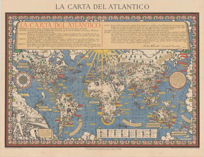
Auction 180, Lot 24
Subject: World, World War II
Gill, MacDonald
La Carta del Atlantico, 1943
Size: 43 x 29.8 inches (109.2 x 75.7 cm)
Estimate: $2,300 - $2,750
Rare Spanish Edition of Gill's "Time & Tide" Map of the Atlantic Charter
Sold for: $3,250
Closed on 11/18/2020
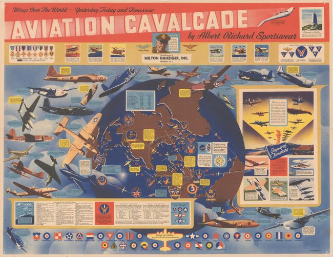
Auction 180, Lot 25
Subject: World, World War II
Wings Over the World... Yesterday, Today and Tomorrow Aviation Cavalcade by Albert Richard Sportswear, 1944
Size: 21.6 x 16.6 inches (54.9 x 42.2 cm)
Estimate: $1,500 - $1,800
Propaganda Map Promoting US Military Aviation During WWII
Unsold
Closed on 11/18/2020
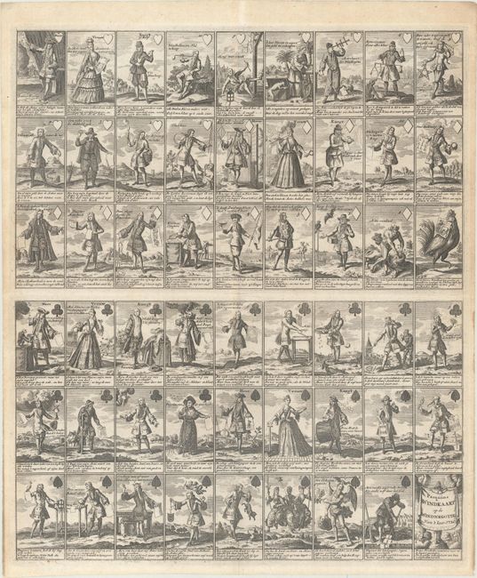
Auction 180, Lot 52
Subject: Cartographic Miscellany, Playing Cards
Anon.
Pasquins Windkaart. Op de Windnegotie van 't Iaar 1720, 1720
Size: 17.3 x 20.4 inches (43.9 x 51.8 cm)
Estimate: $1,500 - $1,800
Sheet of Playing Cards Satirizing the Mississippi Bubble
Unsold
Closed on 11/18/2020
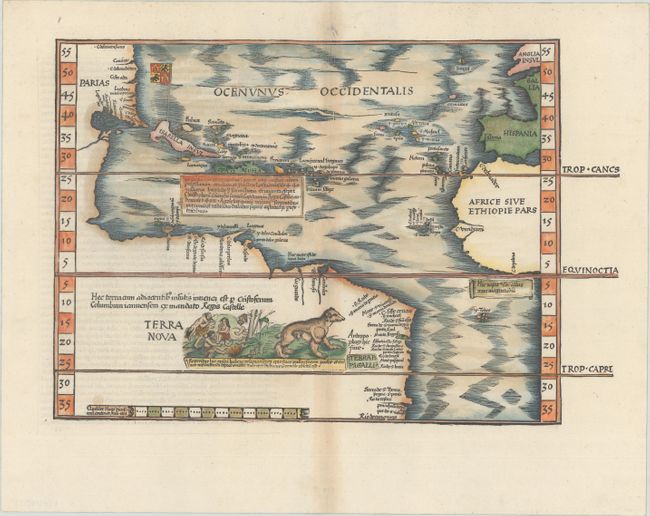
Auction 180, Lot 53
Subject: Western Hemisphere - America, Atlantic Ocean
Waldseemuller/Fries
[Title on Verso] Tabula Terrae Novae, 1541
Size: 16.6 x 11.3 inches (42.2 x 28.7 cm)
Estimate: $9,000 - $11,000
The Waldseemuller/Fries "Admiral's Map"
Sold for: $6,500
Closed on 11/18/2020
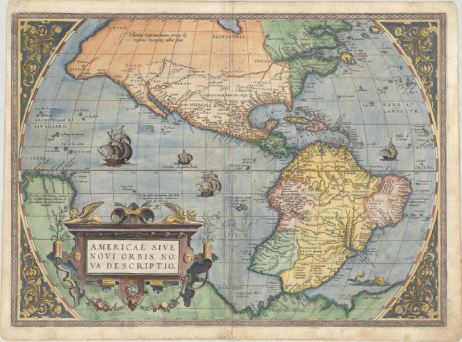
Auction 180, Lot 54
Subject: Western Hemisphere - America
Ortelius, Abraham
Americae sive Novi Orbis, Nova Descriptio, 1572
Size: 20 x 14.4 inches (50.8 x 36.6 cm)
Estimate: $5,000 - $6,500
Rare First Plate of Ortelius' Influential Map of the New World
Sold for: $3,750
Closed on 11/18/2020
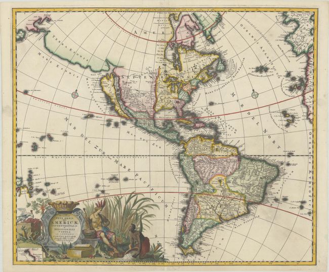
Auction 180, Lot 60
Subject: Western Hemisphere - America
Allard, Carel
Recentissima Novi Orbis, sive Americae Septentrionalis et Meridionalis Tabula, 1697
Size: 22.9 x 19.4 inches (58.2 x 49.3 cm)
Estimate: $1,600 - $1,900
Allard's Elaborate Map of the Western Hemisphere
Sold for: $950
Closed on 11/18/2020
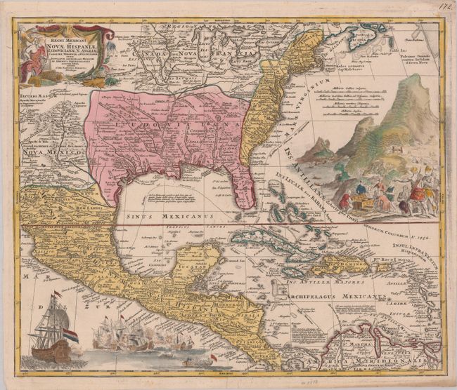
Auction 180, Lot 89
Subject: Colonial Eastern North America & West Indies
Homann, Johann Baptist
Regni Mexicani seu Novae Hispaniae, Ludovicianae, N. Angliae, Carolinae, Virginiae et Pensylvaniae, nec non Insularum Archipelagi Mexicani in America Septentrionali Accurata Tabula, 1720
Size: 22.6 x 18.7 inches (57.4 x 47.5 cm)
Estimate: $1,400 - $1,700
Homann's Decorative Map of Colonial America in the Era of the War of the Spanish Succession
Sold for: $1,800
Closed on 11/18/2020
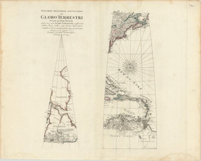
Auction 180, Lot 90
Subject: Colonial Eastern North America & West Indies
Lowitz (Lowizio), George Moritz
Specimen Trigesimae Sextae Partis ex Globo Terrestri Trium Pedum Parisin..., 1749
Size: 14 x 17 inches (35.6 x 43.2 cm)
Estimate: $1,600 - $2,000
Rare Globe Gore Broadside for a Globe that Was Never Produced
Sold for: $1,200
Closed on 11/18/2020
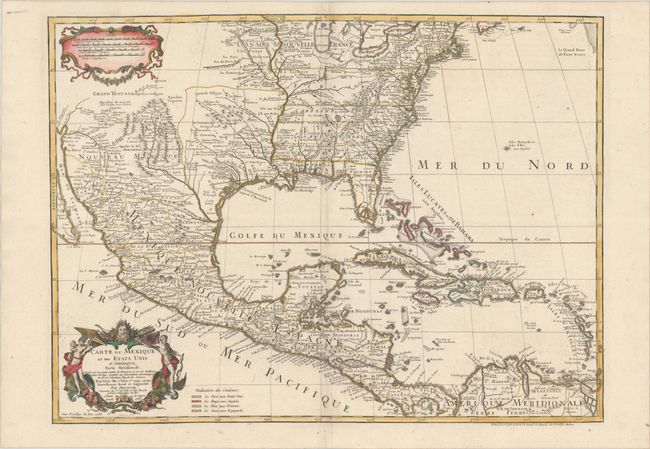
Auction 180, Lot 91
Subject: Colonial Eastern North America & West Indies
Delisle/Dezauche
Carte du Mexique et des Etats Unis d'Amerique, Partie Meridionale. Dressee sur un Grand Nombre de Memoires..., 1783
Size: 25.5 x 18.9 inches (64.8 x 48 cm)
Estimate: $1,200 - $1,500
One of the Earliest Maps to Name the United States
Sold for: $900
Closed on 11/18/2020
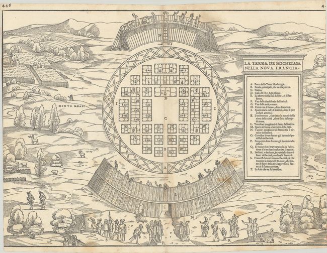
Auction 180, Lot 98
Subject: Montreal, Canada
Gastaldi/Ramusio
La Terra de Hochelaga Nella Nova Francia, 1556
Size: 14.9 x 10.9 inches (37.8 x 27.7 cm)
Estimate: $2,000 - $2,300
Rare First Edition of the First Published Plan of a Settlement in North America
Sold for: $1,500
Closed on 11/18/2020
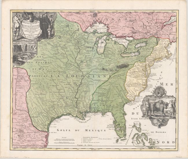
Auction 180, Lot 106
Subject: Colonial Eastern United States & Canada
Homann, Johann Baptist
Amplissimae Regionis Mississipi seu Provinciae Ludovicianae a R.P. Ludovico Hennepin Francisc Miss in America Septentrionali Anno 1687..., 1720
Size: 22.6 x 19.1 inches (57.4 x 48.5 cm)
Estimate: $2,200 - $2,500
Striking Map of Colonial America with Buffalo Vignette
Sold for: $2,750
Closed on 11/18/2020
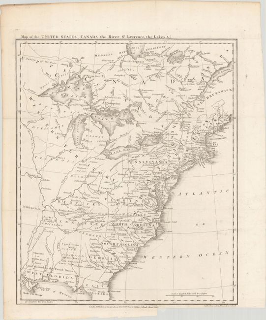
Auction 180, Lot 109
Subject: Eastern United States & Canada, Franklin
Phillips, Richard (Sir)
Map of the United States, Canada the River St. Lawrence, the Lakes &c., 1801
Size: 13.4 x 16 inches (34 x 40.6 cm)
Estimate: $1,400 - $1,700
Features the Short-Lived Franklinia and Morgania
Sold for: $1,000
Closed on 11/18/2020
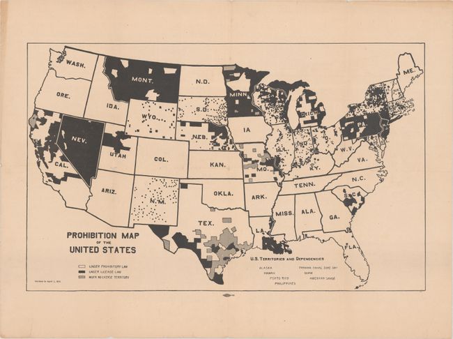
Auction 180, Lot 130
Subject: United States
Prohibition Map of the United States, 1915
Size: 21.3 x 13.2 inches (54.1 x 33.5 cm)
Estimate: $300 - $400
Rare Map Issued 5 Years Before the Prohibition Amendment Passed
Sold for: $325
Closed on 11/18/2020
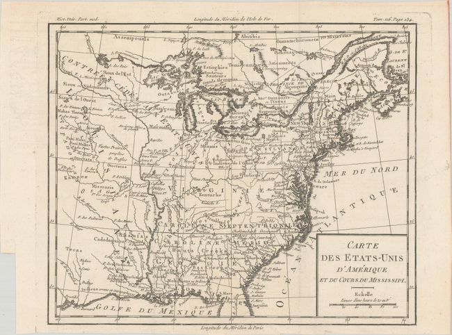
Auction 180, Lot 144
Subject: Eastern United States, Franklin
Brion de la Tour, Louis
Carte des Etats-Unis d'Amerique et du Cours du Mississipi, 1788
Size: 10.6 x 8.7 inches (26.9 x 22.1 cm)
Estimate: $900 - $1,100
One of the Earliest Maps to Feature the State of Franklin
Sold for: $650
Closed on 11/18/2020
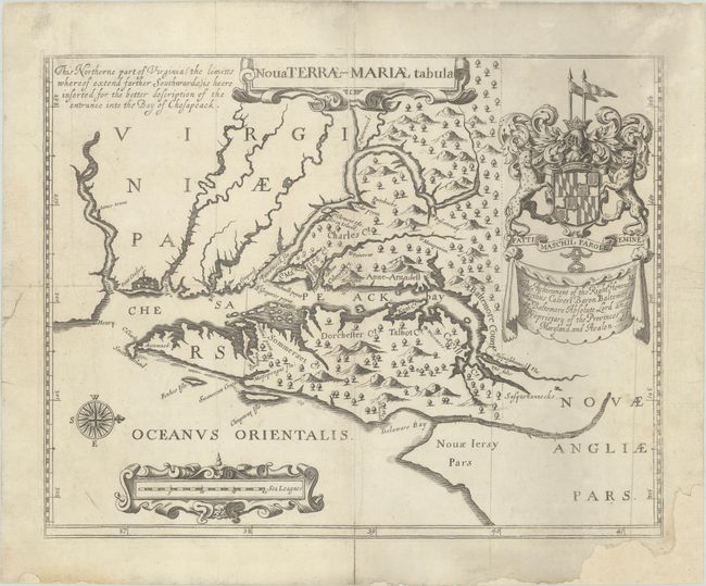
Auction 180, Lot 158
Subject: Colonial Mid-Atlantic United States, Maryland
Ogilby, John
Nova Terrae-Mariae Tabula, 1671
Size: 14.8 x 11.6 inches (37.6 x 29.5 cm)
Estimate: $4,750 - $6,000
Ogilby's Copy of the Extremely Rare "Lord Baltimore's Map," the Earliest Obtainable Printed Map of Maryland
Sold for: $3,500
Closed on 11/18/2020
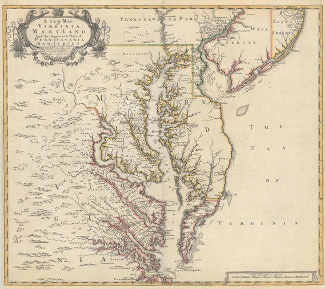
Auction 180, Lot 162
Subject: Colonial Mid-Atlantic United States
Browne/Senex
A New Map of Virginia Mary-land and the Improved Parts of Pennsylvania & New Jersey..., 1719
Size: 21.8 x 19.1 inches (55.4 x 48.5 cm)
Estimate: $4,000 - $5,000
Map of Chesapeake Bay Based on Landmark Herrman Map
Unsold
Closed on 11/18/2020
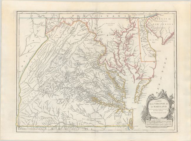
Auction 180, Lot 164
Subject: Mid-Atlantic United States
Robert de Vaugondy, Didier
Carte de la Virginie et du Maryland Dressee sur la Grande Carte Angloise de Mrs. Josue Fry et Pierre Jefferson, 1793
Size: 25.2 x 19 inches (64 x 48.3 cm)
Estimate: $1,600 - $1,900
An Essential Map of Virginia and Maryland
Unsold
Closed on 11/18/2020
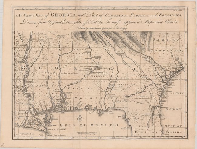
Auction 180, Lot 171
Subject: Colonial Southeastern United States
Bowen, Emanuel
A New Map of Georgia, with Part of Carolina, Florida and Louisiana. Drawn from Original Draughts, Assisted by the Most Approved Maps and Charts, 1748
Size: 18.9 x 14.3 inches (48 x 36.3 cm)
Estimate: $2,200 - $2,500
Important Map of the Georgia Colony
Sold for: $2,100
Closed on 11/18/2020
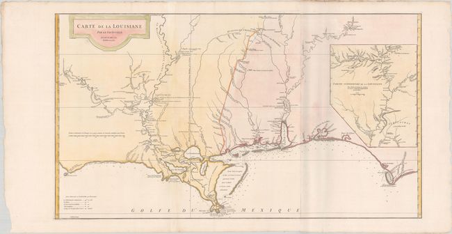
Auction 180, Lot 176
Subject: Colonial Southern United States
Anville, Jean Baptiste Bourguignon d'
Carte de la Louisiane par Le Sr. D'Anville Dressee en Mai 1732. Publiee en 1752., 1752
Size: 36.4 x 20.4 inches (92.5 x 51.8 cm)
Estimate: $1,600 - $1,900
An Early, Detailed Depiction of the Gulf Coast
Sold for: $1,200
Closed on 11/18/2020
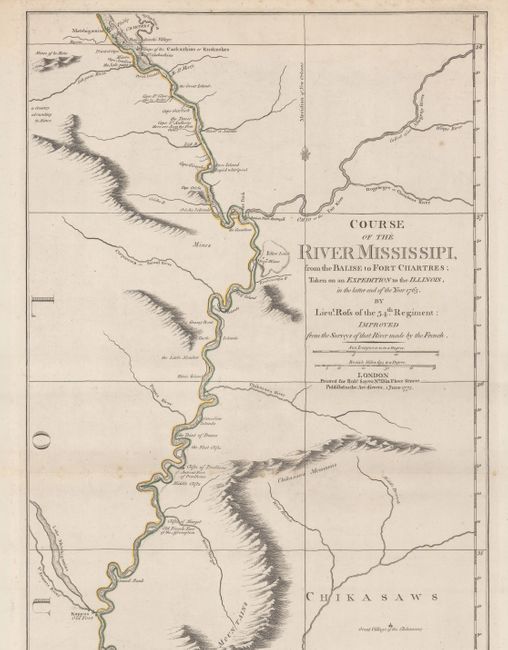
Auction 180, Lot 183
Subject: Colonial Central United States, Mississippi River
Ross, John (Lt.)
Course of the River Mississipi, from the Balise to Fort Chartres; Taken on an Expedition to the Illinois, in the Latter End of the Year 1765, 1775
Size: 13.8 x 44.4 inches (35.1 x 112.8 cm)
Estimate: $3,250 - $4,000
First English Map of the Lower Mississippi River
Unsold
Closed on 11/18/2020
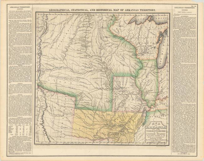
Auction 180, Lot 184
Subject: Central United States, Arkansas
Carey & Lea
Geographical, Historical, and Statistical Map of Arkansas Territory, 1822
Size: 14.6 x 14.4 inches (37.1 x 36.6 cm)
Estimate: $1,400 - $1,700
A Foundation Map in the Cartography of the Louisiana Purchase
Sold for: $1,000
Closed on 11/18/2020
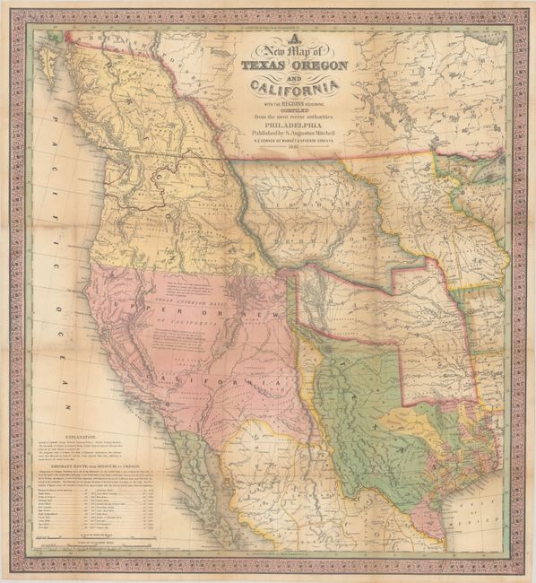
Auction 180, Lot 189
Subject: Western United States, Texas
Mitchell, Samuel Augustus
A New Map of Texas Oregon and California with the Regions Adjoining. Compiled from the Most Recent Authorities, 1846
Size: 20.5 x 22.4 inches (52.1 x 56.9 cm)
Estimate: $11,000 - $14,000
One of the Most Influential Maps of Westward Expansion
Sold for: $8,000
Closed on 11/18/2020
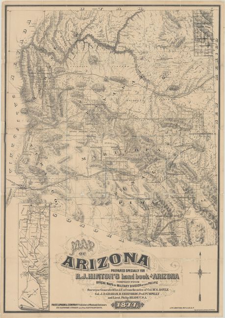
Auction 180, Lot 215
Subject: Arizona
Hinton, Richard J.
Map of Arizona Prepared Specially for R.J. Hinton's Hand Book of Arizona Compiled from Official Maps of Military Division of the Pacific… [with] The Hand-book to Arizona: Its Resources, History, Towns, Mines, Ruins and Scenery..., 1877
Size: 24.1 x 34.6 inches (61.2 x 87.9 cm)
Estimate: $6,000 - $8,000
One of the Earliest Large-Scale Maps of Arizona Territory
Unsold
Closed on 11/18/2020
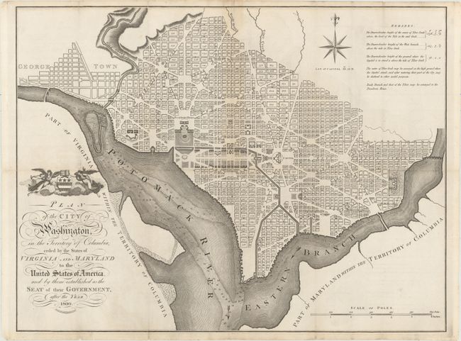
Auction 180, Lot 242
Subject: Washington, D.C.
Russell, John C.
Plan of the City of Washington, in the Territory of Columbia, Ceded by the States of Virginia and Maryland to the United States of America, and by Them Established as the Seat of Their Government, After the Year 1800, 1795
Size: 20.9 x 15.9 inches (53.1 x 40.4 cm)
Estimate: $2,200 - $2,500
Rare, Early, Large-Format Map of Washington D.C.
Sold for: $1,900
Closed on 11/18/2020
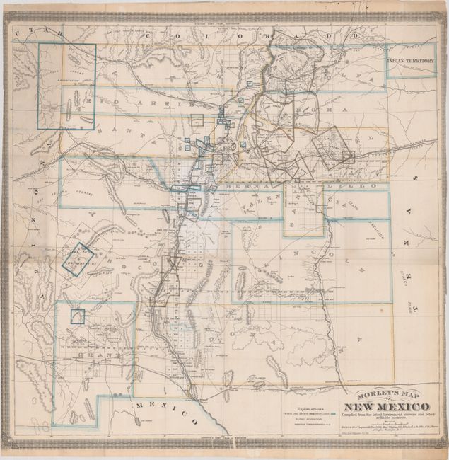
Auction 180, Lot 269
Subject: New Mexico
Morley's Map of New Mexico Compiled from the Latest Government Surveys and Other Reliable Sources, 1873
Size: 24.8 x 24.2 inches (63 x 61.5 cm)
Estimate: $12,000 - $15,000
One of the Earliest Maps Dedicated to New Mexico Territory
Unsold
Closed on 11/18/2020
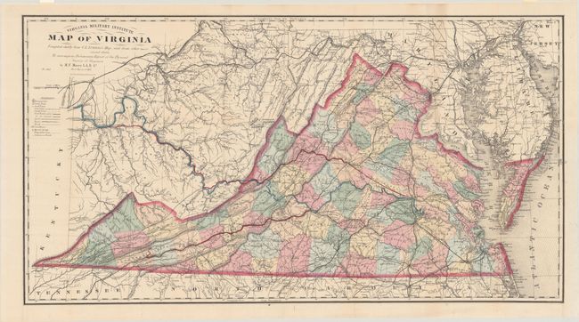
Auction 180, Lot 303
Subject: Virginia, Civil War Reconstruction
Maury, M. F.
Virginia Military Institute Map of Virginia [with] Physical Survey of Virginia. Geographical Position of Its Commercial Advantages, and National Importance. (Preliminary Report), 1868
Size: 34.9 x 18.6 inches (88.6 x 47.2 cm)
Estimate: $1,400 - $1,700
Includes the Third Edition of the Bucholtz-Ludwig Map of 1858 in Fine Condition
Sold for: $1,000
Closed on 11/18/2020
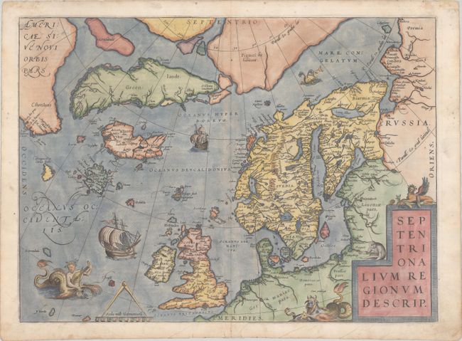
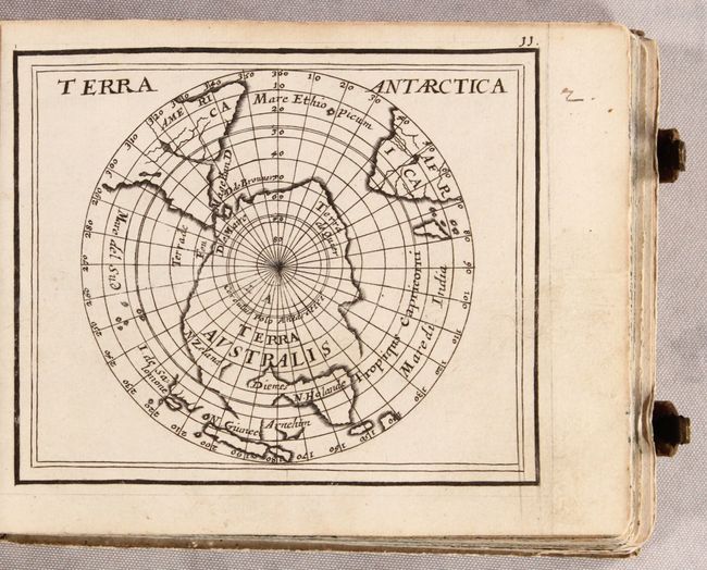
Auction 180, Lot 389
Subject: Arctic & Scandinavia
Ortelius, Abraham
Septentrionalium Regionum Descrip., 1572
Size: 19.2 x 14 inches (48.8 x 35.6 cm)
Estimate: $2,200 - $2,500
Ortelius' Map of the Arctic with Mythical Islands
Sold for: $2,100
Closed on 11/18/2020
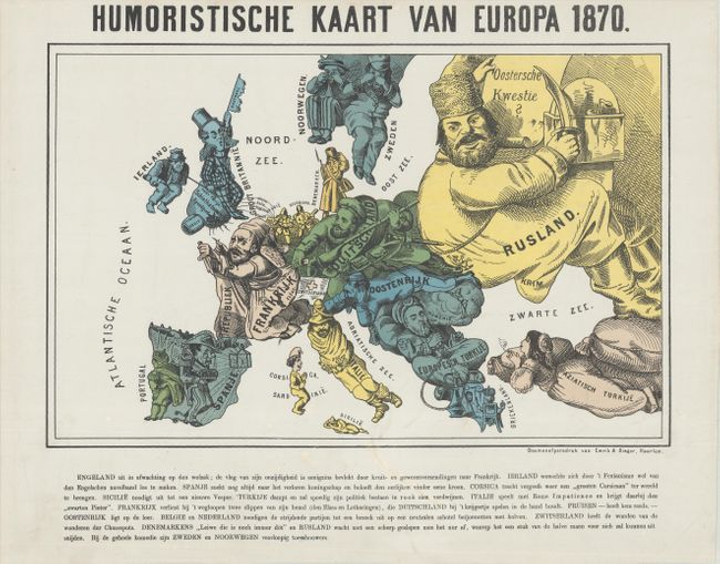
Auction 180, Lot 395
Subject: Europe, War
Emrik & Binger
[Lot of 2] Humoristische Kaart van Europa 1870 [and] Nieuwe Kaart van Europa 1870, 1870
Size: See Description
Estimate: $1,500 - $1,800
Pair of Satirical Dutch Maps Showing Contrasting Views at the Outset of the Franco-Prussian War
Sold for: $850
Closed on 11/18/2020
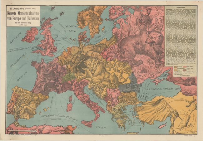
Auction 180, Lot 396
Subject: Europe, World War I
II. Ausgabe (Sommer 1915). Neueste Momentaufnahme von Europa und Halbasien, 1915
Size: 26.6 x 17.9 inches (67.6 x 45.5 cm)
Estimate: $1,200 - $1,500
Rare Updated Propaganda Map from WWI in Support of Central Powers
Sold for: $950
Closed on 11/18/2020
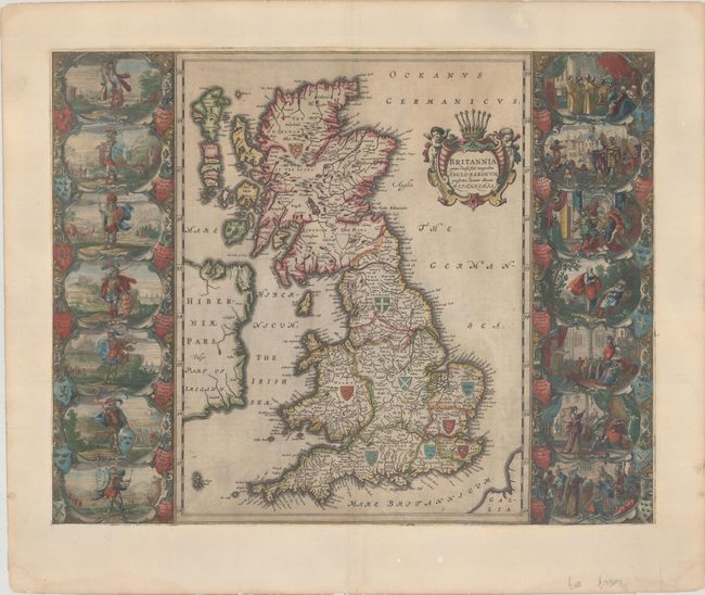
Auction 180, Lot 401
Subject: Britain
Blaeu, Johannes
Britannia Prout Divisa suit Temporibus Anglo-Saxonum, Praesertim Durante Illorum Heptarchia, 1658
Size: 20.8 x 16.3 inches (52.8 x 41.4 cm)
Estimate: $2,000 - $2,300
Decorative Map of Britain with Vignettes of Saxon History - Spanish Edition
Sold for: $1,200
Closed on 11/18/2020
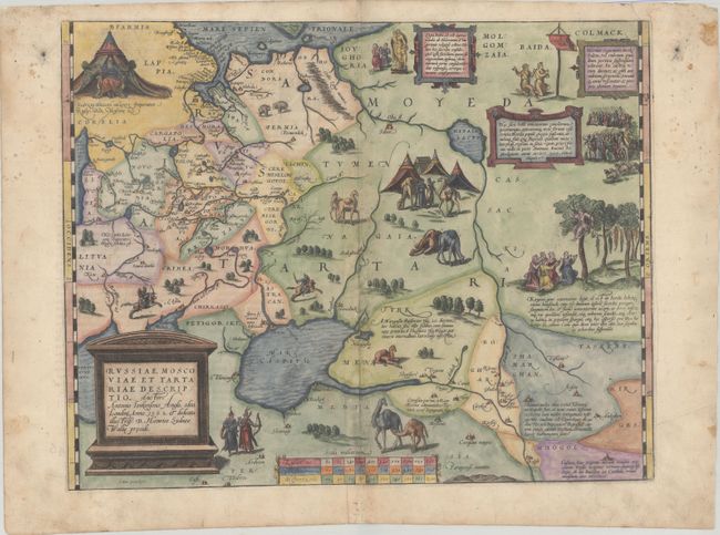
Auction 180, Lot 540
Subject: Russia, Eastern Europe & Central Asia
Ortelius, Abraham
Russiae, Moscoviae et Tartariae Descriptio. Auctore Antonio Ienkensono Anglo..., 1572
Size: 17.3 x 13.6 inches (43.9 x 34.5 cm)
Estimate: $1,600 - $1,900
Ortelius' Map of Russia with a Vignette of Ivan the Terrible
Sold for: $1,500
Closed on 11/18/2020
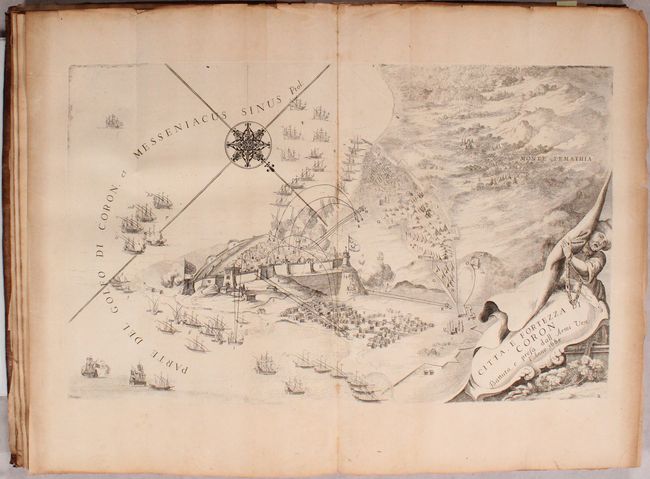
Auction 180, Lot 567
Subject: Southern Greece
Coronelli, Vincenzo Maria
Description Geographique, et Historique de la Moree, Reconquise par les Venitiens. du Royaume de Negrepont..., 1687
Size: 9.9 x 14.9 inches (25.1 x 37.8 cm)
Estimate: $2,300 - $2,750
Attractive Plates of Southern Greece
Sold for: $1,600
Closed on 11/18/2020
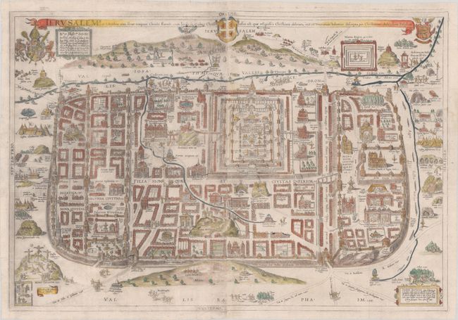
Auction 180, Lot 644
Subject: Jerusalem, Holy Land
Adrichom, Christian van
Ierusalem I., et Suburbia eius, Sicut Tempore Christi Floruit, cum Locis, in Quibus Christus Passus est…, 1584
Size: 29.1 x 19.7 inches (73.9 x 50 cm)
Estimate: $2,000 - $2,400
First Edition of Adrichom's Influential Bird's-Eye Plan of Jerusalem
Unsold
Closed on 11/18/2020
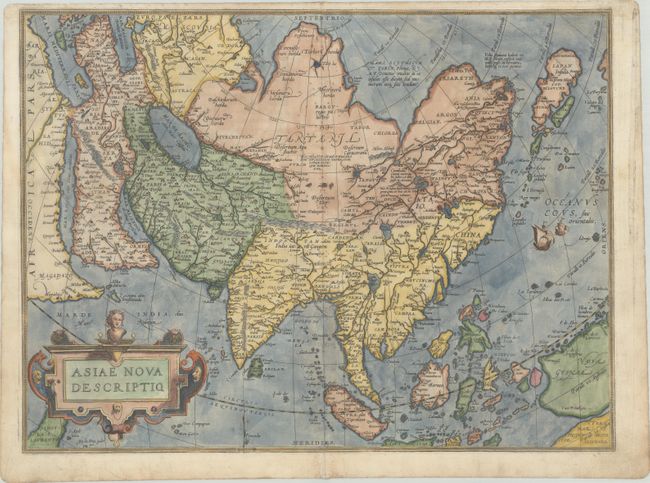
Auction 180, Lot 662
Subject: Asia
Ortelius, Abraham
Asiae Nova Descriptio, 1572
Size: 19.3 x 14.4 inches (49 x 36.6 cm)
Estimate: $1,500 - $1,800
Rare First Plate of Ortelius' Important Map of Asia
Sold for: $1,100
Closed on 11/18/2020
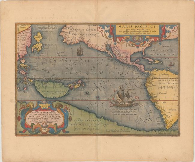
Auction 180, Lot 742
Subject: Pacific Ocean, Western Hemisphere
Ortelius, Abraham
Maris Pacifici, (quod Vulgo Mar del Zur), cum Regionibus Circumiacentibus, Insulisque in Eodem Passim Sparsis, Novissima Descriptio, 1589
Size: 19.6 x 13.6 inches (49.8 x 34.5 cm)
Estimate: $7,500 - $9,000
The First Printed Map Devoted to the Pacific in Full Contemporary Color
Sold for: $5,500
Closed on 11/18/2020
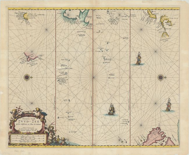
Auction 180, Lot 743
Subject: Pacific Ocean
Goos, Pieter
Pascaerte vande Zuyd-Zee Tussche California, en Ilhas de Ladrones, 1666
Size: 21.4 x 17.5 inches (54.4 x 44.5 cm)
Estimate: $2,400 - $3,000
Goos' Chart of the Pacific Featuring the Island of California and Recent Discoveries in the Region
Sold for: $1,800
Closed on 11/18/2020
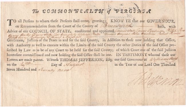
Auction 180, Lot 779
Subject: Document - Thomas Jefferson
Jefferson, Thomas
[Thomas Jefferson Appointment Signed], 1779
Size: 10.6 x 6.1 inches (26.9 x 15.5 cm)
Estimate: $9,500 - $11,000
An Uncommon Signature During Jefferson's Governorship of Virginia
Unsold
Closed on 11/18/2020
Auction 180, Lot 793
Subject: Atlases
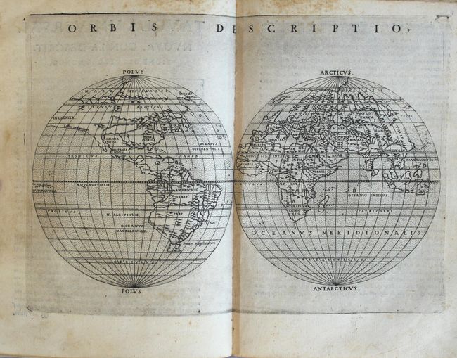
Ptolemy/Ruscelli
La Geografia di Claudio Tolomeo Alessandrino..., 1574
Size: 6.6 x 9.1 inches (16.8 x 23.1 cm)
Estimate: $9,000 - $11,000
Ruscelli's Complete, Third Edition Atlas
Sold for: $5,500
Closed on 11/18/2020
Auction 180, Lot 794
Subject: Atlases
Duval/Beer
[Geographia Universalis...], 1678
Size: 6.1 x 4.9 inches (15.5 x 12.4 cm)
Estimate: $5,000 - $6,000
Miniature Atlas with 82 Maps Based on Duval
Sold for: $2,500
Closed on 11/18/2020
Auction 180, Lot 796
Subject: Atlases
Finley, Anthony
A New General Atlas, Comprising a Complete Set of Maps, Representing the Grand Divisions of the Globe..., 1832
Size: 11.1 x 14.3 inches (28.2 x 36.3 cm)
Estimate: $4,750 - $6,000
An Early and Important American Atlas - Complete
Sold for: $4,250
Closed on 11/18/2020
Auction 180, Lot 797
Subject: Atlases
Tallis, John
The Illustrated Atlas, and Modern History of the World…, 1851
Size: 11.2 x 15.2 inches (28.4 x 38.6 cm)
Estimate: $4,750 - $6,000
Tallis' Decorative Atlas Complete with 81 Maps
Sold for: $3,750
Closed on 11/18/2020
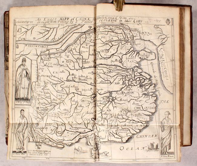
Auction 180, Lot 805
Subject: Exploration and Surveys, Russia & Persia
Olearius, Adam
The Voyages & Travels of the Ambassadors from the Duke of Holstein, to the Great Duke of Muscovy, and the King of Persia..., 1662
Size: 7.8 x 11.9 inches (19.8 x 30.2 cm)
Estimate: $2,200 - $2,500
First English Edition of Olearius' Travels through Russia and Persia
Sold for: $2,100
Closed on 11/18/2020
Auction 180, Lot 806
Subject: Miscellaneous Books
Malham, John (Rev.)
[2 Volumes] The Naval Gazetteer; or, Seaman's Complete Guide. Containing a Full and Accurate Account..., 1795
Size: 5.3 x 8.3 inches (13.5 x 21.1 cm)
Estimate: $1,400 - $1,700
Complete First Edition of Malham's Gazetteer
Unsold
Closed on 11/18/2020
46 lots