Catalog Archive
Auction 180, Lot 396

Rare Updated Propaganda Map from WWI in Support of Central Powers

"II. Ausgabe (Sommer 1915). Neueste Momentaufnahme von Europa und Halbasien",

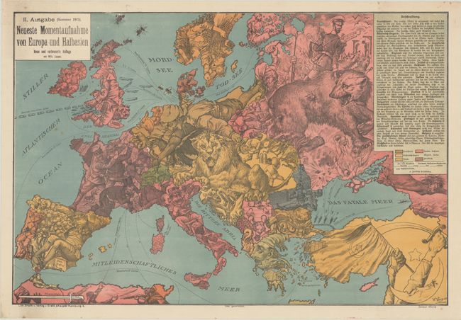
Subject: Europe, World War I

Period: 1915 (dated)

Publication:

Color: Printed Color

Size:
26.6 x 17.9 inches
67.6 x 45.5 cm
Download High Resolution Image
(or just click on image to launch the Zoom viewer)

This rare and fascinating political propaganda map was created by Wilhelm Kaspar and gives a German perspective of World War I during the summer of 1915. Kaspar created an earlier version of this map at the outset of the war in 1914 (see the 1914 edition), yet as so much changed over the course of a few months, he updated the imagery on the map and added a block of text in this "new and improved" 1915 edition. As with the previous edition, the key countries involved in the war are represented by human or animal caricatures with various props that help illustrate the situation.

At the center of the conflict are Germany, Austria-Hungary and Russia. Germany is represented by both an eagle and a Deutsche Michel (an ordinary or average German), who clenches the French border in his right hand while doing the splits to hold back the French soldiers with one foot as the other foot kicks a Russian soldier. Austria-Hungary is depicted as a ferocious lion surrounded by soldiers aiming their cannons and other weapons at Russia and Italy. The Russian bear, surrounded by Russian soldiers and scenes of civil strife, who was previously depicted attacking Austria-Hungary now runs away crying from its enemy's bullets. France, which was previously depicted as soldiers fleeing German advances, is now illustrated as British and French soldiers attempting to push back Germany while a financier secretly hands Italy coins, demonstrating Italy joining the Triple Entente. Italy had previously been depicted as a Roman goddess statue due to its neutral status, but now is shown as King Victor Emmanuel clenching a contract with Germany while stabbing himself in the heart as the result of turning on its former alliance with Germany. A frightened-looking British soldier sits astride a bulldog while a venomous snake from the India strikes from behind. Turkey flies a Turkish flag while holding a scimitar. Neutral Switzerland was previously shown as a porcupine and now is depicted as a four-way jack trying to hold its boundaries from the encroachment of its neighbors.

In this 1915 edition, Kaspar has introduced the use of color to further signify the alliances in the war. The Triple Alliance is called the "New Loyal Alliance" and is shown in shades of yellow; the Triple Entente is called the "enemy of the Loyal Alliance" and depicted in shades of pink; neutral countries are shown in green. The German text at top right explains the imagery for each country depicted. Published by Graht & Kaspar.

Although the human personification of continents and countries can be seen as early as the 14th century (on maps by Opicinus de Canestris), human and animal metaphors on maps reached a new level in Europe between 1845 and 1945 with political cartoon maps. The rise of these satirical maps reflected the momentous political and cultural changes that occurred during the time. Political leaders were caricaturized and European nations were given symbolic identities that lent humor and accessibility to the geographical map. Based on popular stereotypes, these visual representations even found their way into the classroom to help bring geography and politics to life. Original serio-comic maps are very scarce due to their ephemeral nature.

References:

Condition: A

An excellent example on a bright sheet with full margins, a couple of minor spots of foxing, and some light creasing along the edges of the sheet.

Estimate: $1,200 - $1,500

Sold for: $950

Closed on 11/18/2020

Archived