Subject: Pacific Ocean
Period: 1666 (dated)
Publication: De Zee-Atlas, ofte Water-Weereld
Color: Hand Color
Size:
21.4 x 17.5 inches
54.4 x 44.5 cm
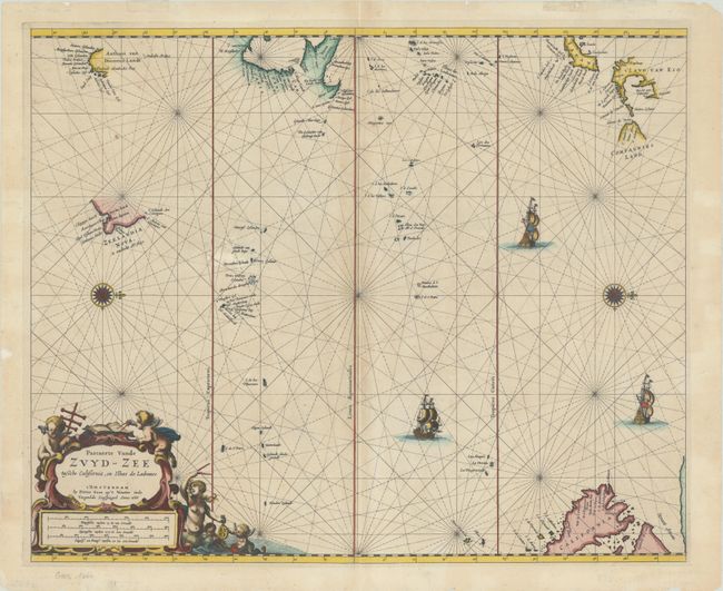
This very unusual sea chart is focused strictly on the Pacific Ocean. It is oriented with north to the right by two fine compass roses. The northern part of the island of California appears at bottom, based on the Foxe model. Japan, t'Land van Eso, and Compagnies Land reflect the discoveries of Maarten Gerritsz de Vries. Further Dutch discoveries are shown including Anthoni van Diemens Landt (Gulf of Carpentaria) and the discoveries of Abel Tasman in New Zeland and Tasmania. Three sailing ships decorate the ocean, which is crisscrossed by rhumb lines. There is an ornate title cartouche at bottom left featuring a mermaid and putti with navigational tools.
Pieter Goos's important sea atlas covered the whole world and was aimed as much at the merchant market as for sea captains. His charts were very influential. This is the second state, with only one recorded example of the first state according to Burden.
References: Burden #378; McLaughlin #34.
Condition: B+
A crisp impression on a bright sheet with minor toning along the centerfold and minor scattered foxing. There are professional repairs to a long separation along the centerfold, a couple of tiny tears in the South Pacific, a chip along the left edge of the sheet, and some short tears along the edges of the sheet, not affecting the image.