Showing Featured Lots(remove filter)
Showing results for:Auction 164
Catalog Archive
104 lots
Page 1 of 3
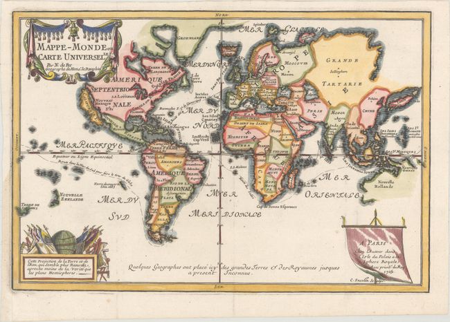
Auction 164, Lot 2
Subject: World & Continents
Fer, Nicolas de
[Lot of 5] Mappe-Monde ou Carte Universelle [and] L'Amerique, Meridionale et Septentrionale... [and] L'Afrique... [and] L'Asie... [and] L'Europe..., 1705-17
Size: 13.5 x 9.1 inches (34.3 x 23.1 cm)
Estimate: $3,000 - $3,750
Attractive Set of De Fer's Small Maps of the World and Its Continents
Sold for: $2,200
Closed on 9/13/2017
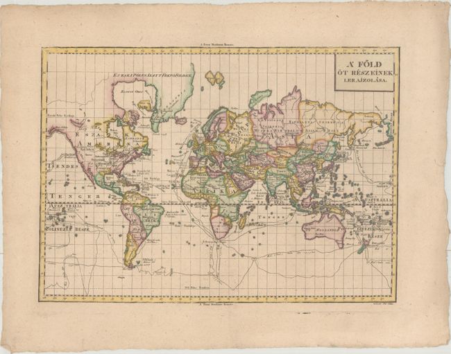
Auction 164, Lot 3
Subject: World & Continents
[Lot of 5] A Fold ot Reszeinek Lerajzolasa [and] Amerika [and] Afrika [and] Asia [and] Europa, 1804
Size: 16.8 x 12.1 inches (42.7 x 30.7 cm)
Estimate: $1,600 - $2,000
Rare Matching Set of Hungarian Maps
Unsold
Closed on 9/13/2017
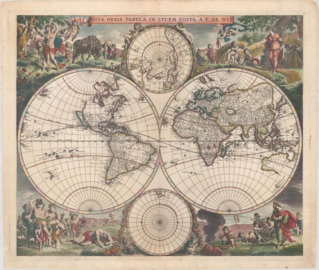
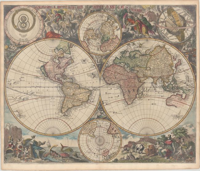
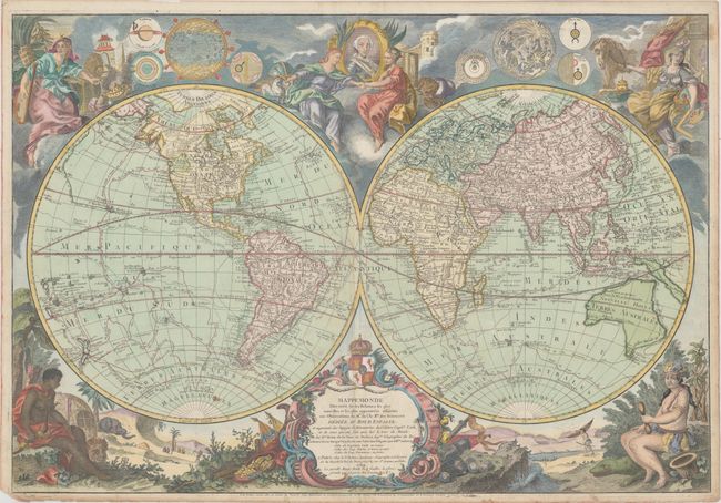
Auction 164, Lot 10
Subject: World
Wit, Frederick de
Nova Orbis Tabula, in Lucem Edita, 1670
Size: 21.9 x 18.4 inches (55.6 x 46.7 cm)
Estimate: $5,000 - $6,000
First State of De Wit's Stunning Double-Hemisphere Map
Sold for: $3,750
Closed on 9/13/2017
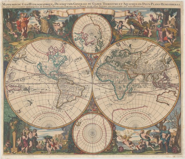
Auction 164, Lot 12
Subject: World
Valck, Gerard
Mappe-Monde Geo-Hydrographique, ou Description Generale du Globe Terrestre et Aquatique en Deux-Plans-Hemispheres..., 1686
Size: 22.8 x 18.9 inches (57.9 x 48 cm)
Estimate: $3,500 - $4,500
Scarce Baroque-Style Double-Hemisphere Map Depicting the Four Seasons
Sold for: $2,500
Closed on 9/13/2017
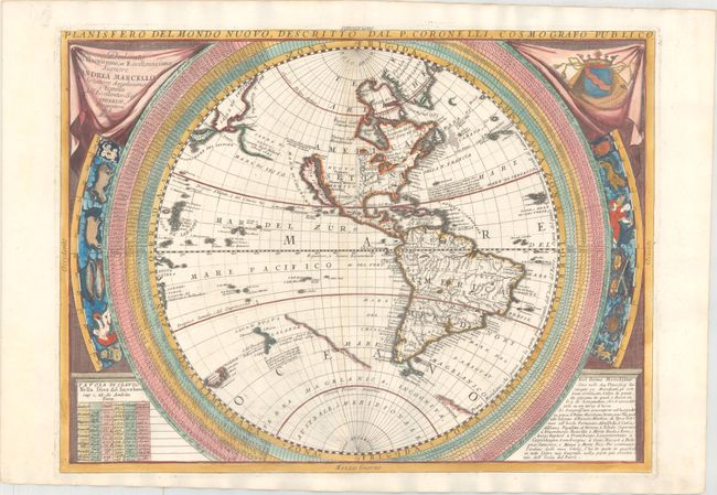
Auction 164, Lot 13
Subject: World
Coronelli, Vincenzo Maria
[Lot of 2] Planisfero del Mondo Nuovo... [and] Planisfero del Mondo Vecchio..., 1691
Size: 24 x 17.8 inches (61 x 45.2 cm)
Estimate: $4,000 - $5,000
Coronelli's Two-Sheet World Map
Sold for: $3,000
Closed on 9/13/2017
Auction 164, Lot 16
Subject: World
Schenk, Pierre
Haemisphaeriorum Tabula Carthesiana, 1700
Size: 23.2 x 19.1 inches (58.9 x 48.5 cm)
Estimate: $3,000 - $3,750
Rare Decorative World Map with Geographical Misconceptions
Sold for: $2,200
Closed on 9/13/2017
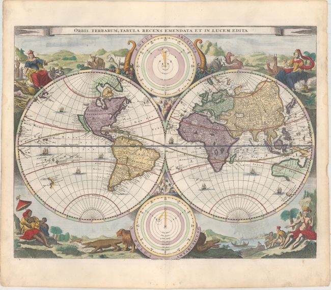
Auction 164, Lot 19
Subject: World
Stoopendaal, Daniel
Orbis Terrarum Tabula Recens Emendata et in Lucem Edita, 1729
Size: 18.1 x 13.9 inches (46 x 35.3 cm)
Estimate: $1,400 - $1,700
Stoopendaal's Decorative Double-Hemisphere World Map
Sold for: $800
Closed on 9/13/2017
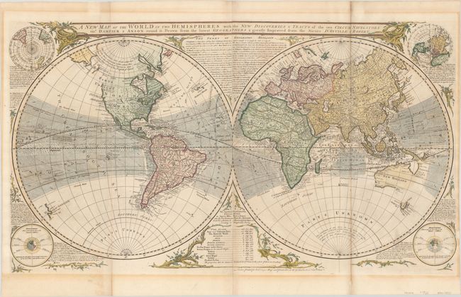
Auction 164, Lot 24
Subject: World
Sayer, Robert
A New Map of the World in Two Hemispheres with the New Discoveries & Tracts of the Two Circum Navigators..., 1760
Size: 37.9 x 21.6 inches (96.3 x 54.9 cm)
Estimate: $3,500 - $4,250
Gorgeous Double Hemisphere World Map
Unsold
Closed on 9/13/2017
Auction 164, Lot 25
Subject: World
Desnos, Louis Charles
Mappemonde Dressee sur les Relations les Plus Nouvelles et les Plus Approuvees Assujeties Dediee au Roi d Espagne: et Augmentee des Voyages et Decouvertes du Celebre Capite. Cook..., 1789
Size: 30 x 20.6 inches (76.2 x 52.3 cm)
Estimate: $3,750 - $4,500
Scarce Map Featuring Interesting Cartography in the Northwest
Sold for: $1,900
Closed on 9/13/2017
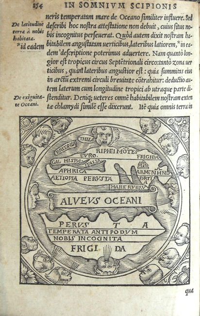
Auction 164, Lot 29
Subject: Ancient World
Macrobius, Ambrosius Aurelius Theodo
Macrobii Ambrosii Aurelii Theodosii, Viri Consularis, & Illustris, in Somnium Scipionis, Lib. II. Saturnaliorum, Lib. VII..., 1548
Size: 4.3 x 6.7 inches (10.9 x 17 cm)
Estimate: $1,500 - $1,800
Macrobius' Miniature Ancient World Map
Sold for: $1,000
Closed on 9/13/2017
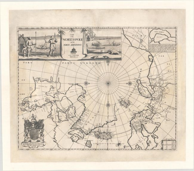
Auction 164, Lot 34
Subject: North Pole
Pitt, Moses
A Map of the North-Pole and the Parts Adioining, 1680
Size: 23.4 x 18.2 inches (59.4 x 46.2 cm)
Estimate: $2,750 - $3,500
Attractive English Map of the North Pole
Sold for: $2,000
Closed on 9/13/2017
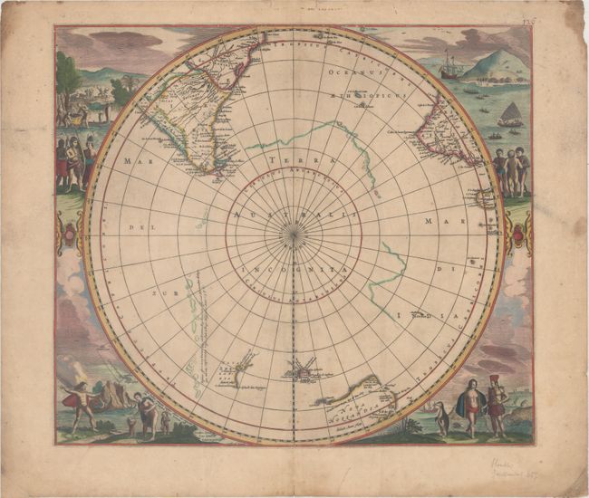
Auction 164, Lot 36
Subject: South Pole
Hondius/Jansson
[Polus Antarcticus], 1666
Size: 19.1 x 16.8 inches (48.5 x 42.7 cm)
Estimate: $1,900 - $2,200
Rare Edition with New Zealand, Tasmania and "Nova Hollandia"
Unsold
Closed on 9/13/2017
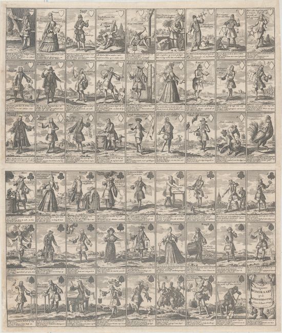
Auction 164, Lot 43
Subject: Cartographic Miscellany, Playing Cards
Anon.
Pasquins Windkaart. Op de Windnegotie, 1720
Size: 17.2 x 20.2 inches (43.7 x 51.3 cm)
Estimate: $1,200 - $1,500
Sheet of Playing Cards Satirizing the Mississippi Bubble
Sold for: $1,600
Closed on 9/13/2017
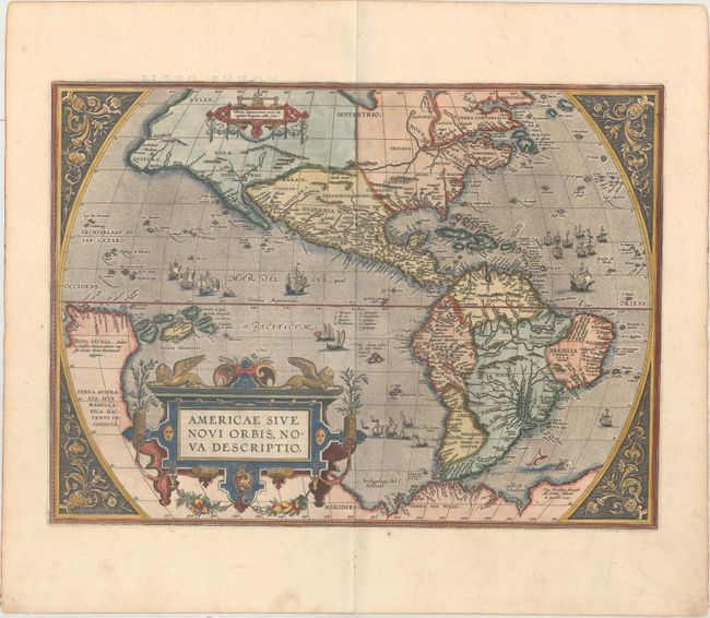
Auction 164, Lot 45
Subject: Western Hemisphere - America
Ortelius, Abraham
Americae sive Novi Orbis, Nova Descriptio, 1587
Size: 19.1 x 14 inches (48.5 x 35.6 cm)
Estimate: $4,750 - $6,000
Ortelius' Influential Map of the New World
Sold for: $4,500
Closed on 9/13/2017
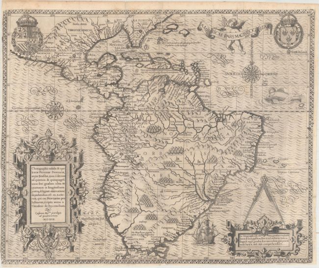
Auction 164, Lot 46
Subject: Western Hemisphere - America
Bry, Theodore de
Americae Pars Magis Cognita, 1592
Size: 17.6 x 14.4 inches (44.7 x 36.6 cm)
Estimate: $4,000 - $5,000
De Bry's Elaborate Map of North and South America
Sold for: $3,750
Closed on 9/13/2017
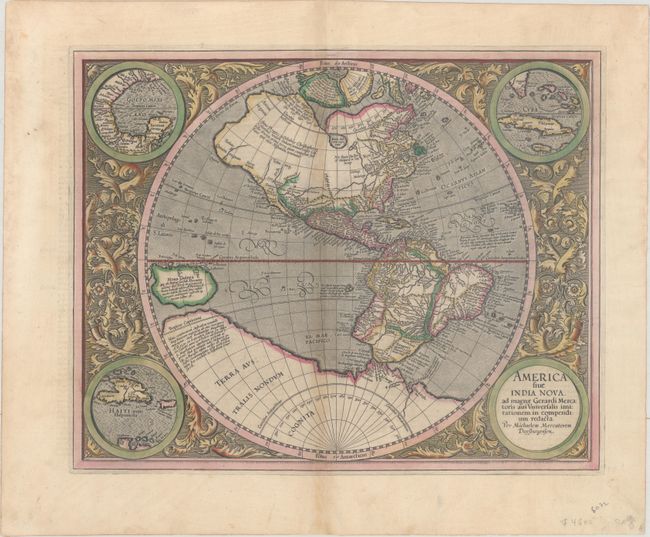
Auction 164, Lot 48
Subject: Western Hemisphere - America
Mercator, Michael
America sive India Nova, ad Magnae Gerardi Mercatoris aui Universalis Imitationem, in Compendium Redacta, 1628
Size: 18.2 x 14.6 inches (46.2 x 37.1 cm)
Estimate: $3,250 - $4,000
Mercator's Foundation Map for the Americas in Full Original Color
Unsold
Closed on 9/13/2017
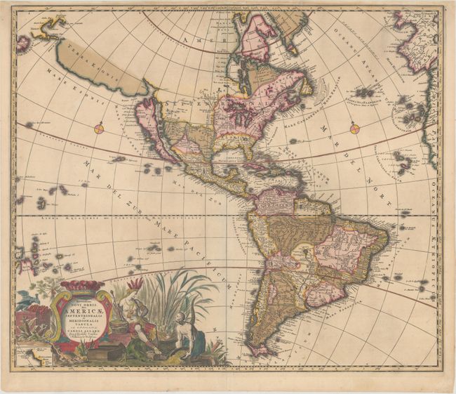
Auction 164, Lot 50
Subject: Western Hemisphere - America
Allard, Carel
Recentissima Novi Orbis, sive Americae Septentrionalis et Meridionalis Tabula, 1700
Size: 23.3 x 19.8 inches (59.2 x 50.3 cm)
Estimate: $1,600 - $1,900
Allard's Elaborate Map of the Western Hemisphere
Unsold
Closed on 9/13/2017
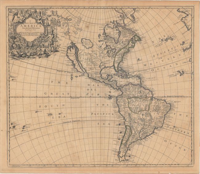
Auction 164, Lot 53
Subject: Western Hemisphere - America
Senex, John
A New Map of America from the Latest Observations, 1719
Size: 22.1 x 19.2 inches (56.1 x 48.8 cm)
Estimate: $1,000 - $1,300
Fascinating Map of the Americas with Unusual Features
Sold for: $550
Closed on 9/13/2017
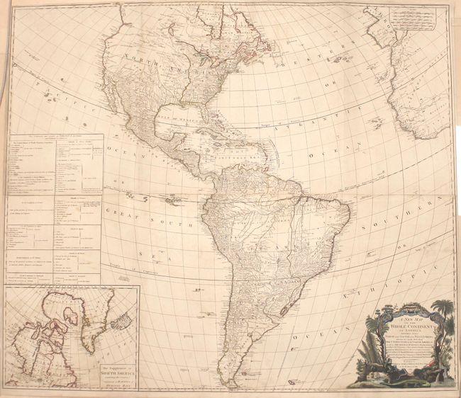
Auction 164, Lot 61
Subject: Western Hemisphere - America
Laurie & Whittle
A New Map of the Whole Continent of America, Divided into North and South and West Indies. Wherein Are Exactly Described the United States of North America..., 1794
Size: 46.8 x 40.6 inches (118.9 x 103.1 cm)
Estimate: $1,500 - $1,800
Impressive Four-Sheet Map Featuring Two Possible Locations for a River of the West
Unsold
Closed on 9/13/2017
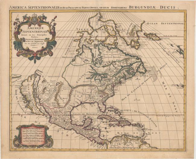
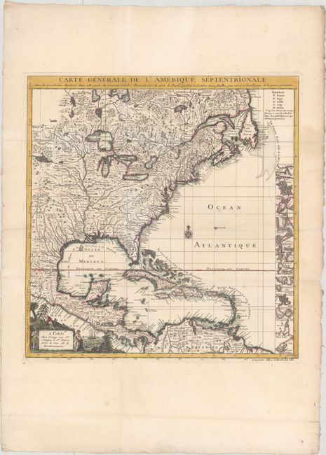
Auction 164, Lot 67
Subject: Colonial North America
Sanson/Jaillot
Amerique Septentrionale Divisee en ses Principales Parties..., 1694
Size: 23 x 18.4 inches (58.4 x 46.7 cm)
Estimate: $2,400 - $3,000
Rare First State with California as an Island
Sold for: $1,900
Closed on 9/13/2017
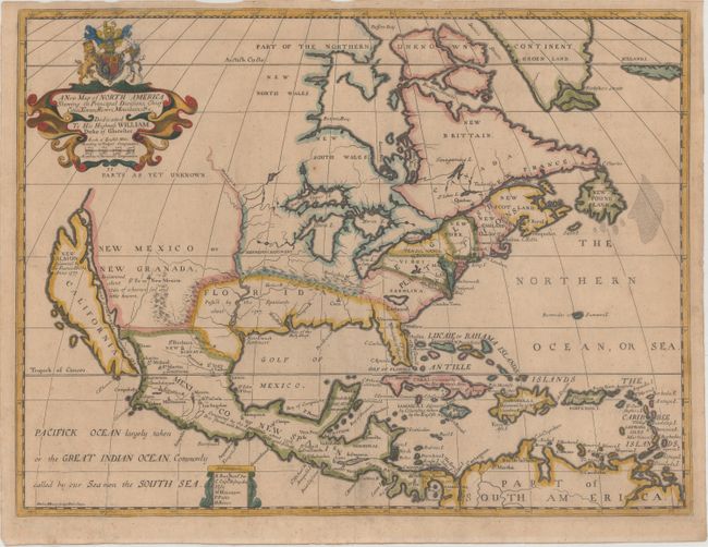
Auction 164, Lot 71
Subject: Colonial North America
Wells, Edward
A New Map of North America Shewing its Principal Divisions, Chief Cities, Townes, Rivers, Mountains, &c., 1704
Size: 19.3 x 14.5 inches (49 x 36.8 cm)
Estimate: $1,400 - $1,700
Wells' Map of North America Featuring California as an Island
Unsold
Closed on 9/13/2017
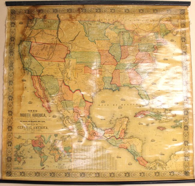
Auction 164, Lot 87
Subject: North America
Monk, Jacob
New Map of That Portion of North America, Exhibiting the United States and Territories, the Canadas, New Brunswick, Nova Scotia, and Mexico, Also, Central America, and the West India Islands..., 1854
Size: 59.1 x 55.6 inches (150.1 x 141.2 cm)
Estimate: $1,100 - $1,400
Large Wall Map Featuring an Enlarged Gold Region of California
Sold for: $700
Closed on 9/13/2017
Auction 164, Lot 93
Subject: Colonial Eastern North America & West Indies
Crepy, (Family)
Carte Generale de l'Amerique Septentrionale avec les Possessions Angloises dans Cette Partie du Nouveau Monde, Dressee sur la Carte de Pople..., 1756
Size: 19.4 x 20.2 inches (49.3 x 51.3 cm)
Estimate: $2,000 - $2,300
French Index Sheet of Popple's Map
Unsold
Closed on 9/13/2017
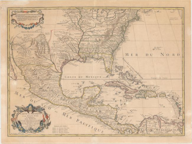
Auction 164, Lot 94
Subject: Colonial Eastern North America & West Indies
Delisle/Dezauche
Carte du Mexique et des Etats Unis d'Amerique, Partie Meridionale. Dressee sur un Grand Nombre de Memoires..., 1783
Size: 26 x 19 inches (66 x 48.3 cm)
Estimate: $1,300 - $1,600
One of the Earliest Maps to Name the United States
Unsold
Closed on 9/13/2017
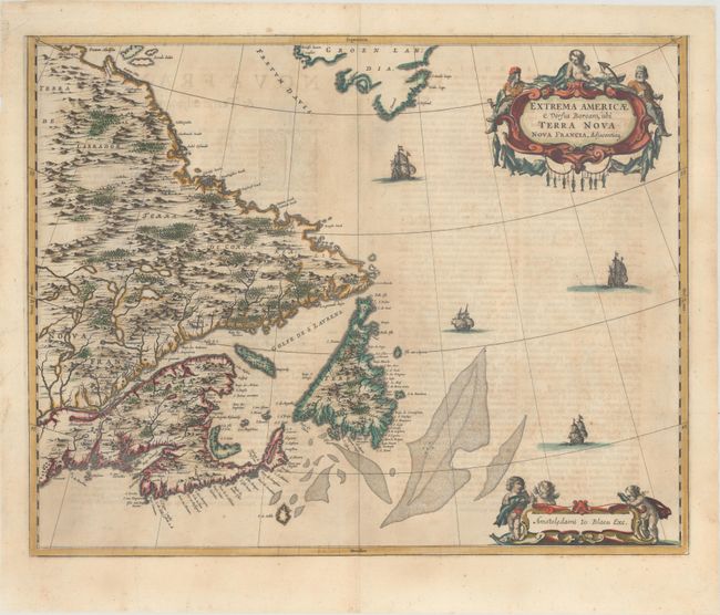
Auction 164, Lot 99
Subject: Eastern Canada
Blaeu, Johannes
Extrema Americae Versus Boream, ubi Terra Nova Nova Francia, Adjacentiaq., 1662
Size: 22.3 x 17.6 inches (56.6 x 44.7 cm)
Estimate: $1,500 - $1,800
Blaeu's Only Map of Canada, Showing the Canadian Maritimes
Sold for: $1,600
Closed on 9/13/2017
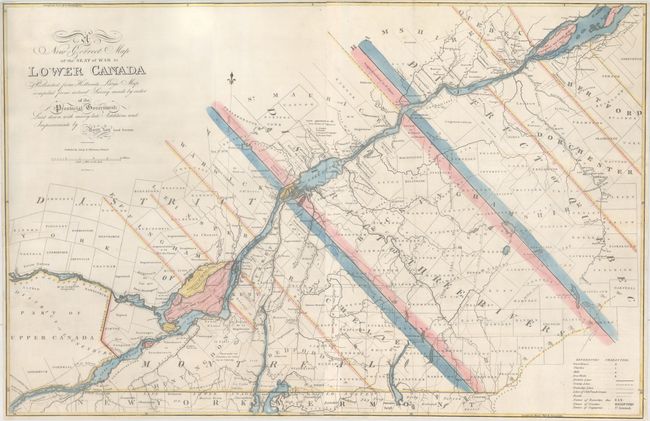
Auction 164, Lot 100
Subject: Eastern Canada, Quebec
Lay, Amos
A New Correct Map of the Seat of War in Lower Canada Protracted from Hollands Large Map Compiled from Actual Survey Made by Order of the Provincial Government..., 1814
Size: 33.1 x 21.6 inches (84.1 x 54.9 cm)
Estimate: $1,600 - $2,000
Lay's Update to Samuel Holland's Map
Sold for: $1,100
Closed on 9/13/2017
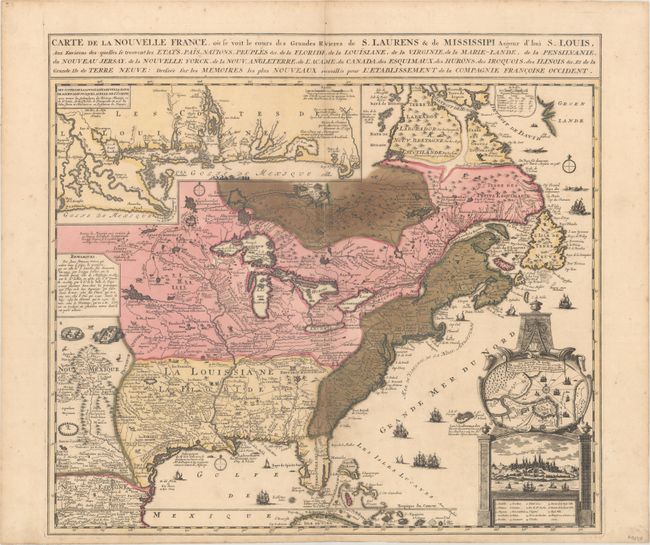
Auction 164, Lot 106
Subject: Colonial Eastern United States & Canada
Fer, Nicolas de
Carte de la Nouvelle France, ou se voit le Cours des Grandes Rivieres de S. Laurens & de Mississipi Aujour d'hui S. Louis, aux Environs Des-quelles se Trouvent les Etats, Pais, Nations, Peuples &c..., 1719
Size: 21.6 x 19.7 inches (54.9 x 50 cm)
Estimate: $1,700 - $2,000
Striking Map of French Colonial Possessions
Sold for: $900
Closed on 9/13/2017
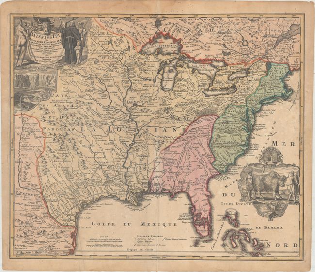
Auction 164, Lot 107
Subject: Colonial Eastern United States & Canada
Homann, Johann Baptist
Amplissimae Regionis Mississipi seu Provinciae Ludovicinae..., 1720
Size: 22.8 x 19.3 inches (57.9 x 49 cm)
Estimate: $1,600 - $1,900
Striking Map of Colonial America with Buffalo Vignette
Sold for: $800
Closed on 9/13/2017
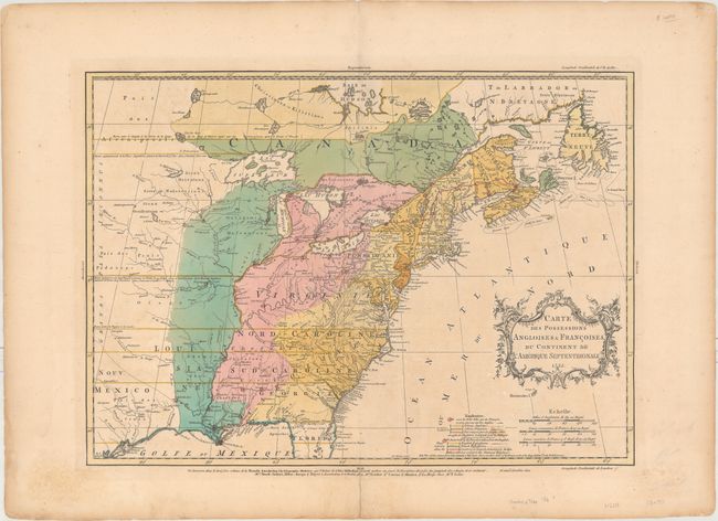
Auction 164, Lot 108
Subject: Colonial Eastern United States & Canada
Palairet, Jean
Carte des Possessions Angloises & Francoises du Continent de l'Amerique Septentrionale, 1755
Size: 22.7 x 16.4 inches (57.7 x 41.7 cm)
Estimate: $2,300 - $2,750
Important Map of French and English Territorial Claims at the Outset of the French and Indian War
Sold for: $1,600
Closed on 9/13/2017
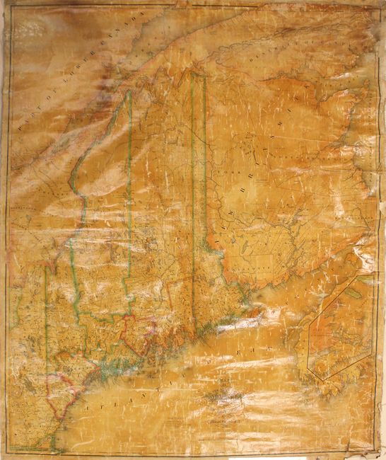
Auction 164, Lot 122
Subject: Maine, Eastern Canada
Greenleaf, Moses
[Wall Map] Map of the State of Maine with the Province of New Brunswick, 1832
Size: 41 x 49.2 inches (104.1 x 125 cm)
Estimate: $1,400 - $1,700
Second Edition of Greenleaf's Large Map of Maine
Sold for: $950
Closed on 9/13/2017
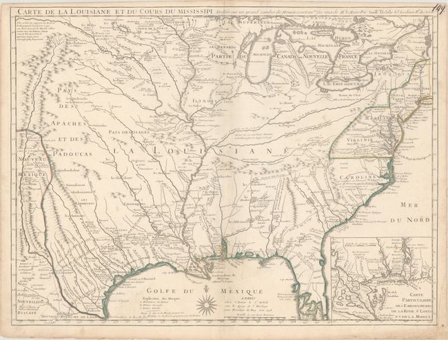
Auction 164, Lot 144
Subject: Colonial Eastern United States
Delisle, Guillaume
Carte de la Louisiane et du Cours du Mississipi Dressee sur un Grand Nombre de Memoires Entrautres sur ceux de Mr. le Maire, 1718
Size: 25.3 x 19.1 inches (64.3 x 48.5 cm)
Estimate: $8,000 - $9,500
A Foundation Map for the Mississippi Valley and the First Appearance of Texas on a Printed Map
Unsold
Closed on 9/13/2017
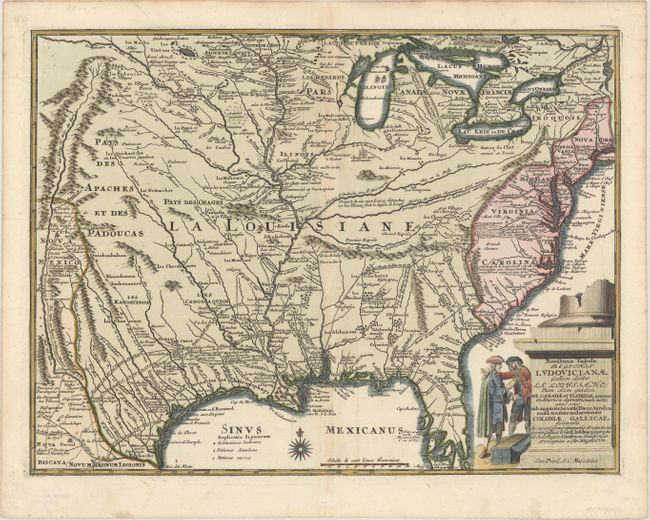
Auction 164, Lot 145
Subject: Colonial Eastern United States
Weigel, Christopher
Novissima Tabula Regionis Ludovicianae Gallice Dictae la Louisiane tam olim Quidem sub Canadae et Floridae Nomine in America Septentrionali..., 1734
Size: 16.5 x 12.5 inches (41.9 x 31.8 cm)
Estimate: $1,400 - $1,700
Uncommon Map of French Louisiana with a Title Cartouche Referencing the Mississippi Bubble Scheme
Sold for: $700
Closed on 9/13/2017
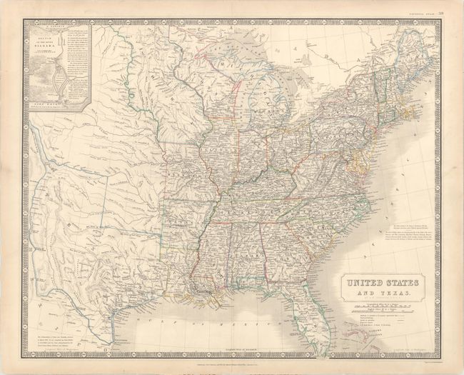
Auction 164, Lot 154
Subject: Eastern United States, Texas
Johnston, W. & A.K.
United States and Texas, 1842
Size: 24 x 19.6 inches (61 x 49.8 cm)
Estimate: $1,100 - $1,400
Highly Detailed British Atlas Map Featuring the Independent Republic of Texas
Sold for: $800
Closed on 9/13/2017
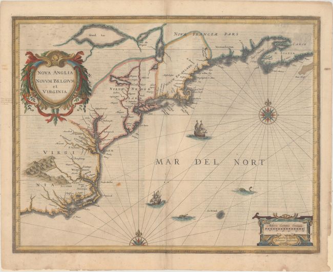
Auction 164, Lot 159
Subject: Colonial New England & Mid-Atlantic United States
Jansson, Jan
Nova Anglia Novum Belgium et Virginia, 1636
Size: 19.7 x 15.3 inches (50 x 38.9 cm)
Estimate: $1,400 - $1,700
Jansson's Influential Map of the East Coast
Sold for: $950
Closed on 9/13/2017
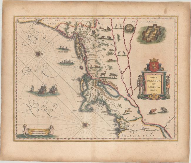
Auction 164, Lot 160
Subject: Colonial New England & Mid-Atlantic United States
Blaeu, Willem
Nova Belgica et Anglia Nova, 1638
Size: 19.9 x 15.3 inches (50.5 x 38.9 cm)
Estimate: $2,500 - $3,500
Important Map of Colonial New England and the Mid-Atlantic
Unsold
Closed on 9/13/2017
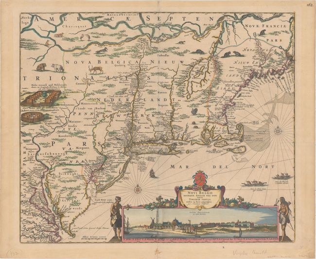
Auction 164, Lot 161
Subject: Colonial New England & Mid-Atlantic United States
Visscher, Nicolas
Novi Belgii Novaeque Angliae nec non Partis Virginiae Tabula Multis in Locis Emendata, 1684
Size: 21.9 x 18.4 inches (55.6 x 46.7 cm)
Estimate: $5,500 - $7,000
Visscher's Influential Map with Early View of New York City
Sold for: $2,900
Closed on 9/13/2017
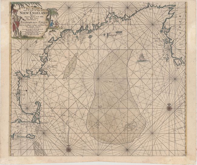
Auction 164, Lot 163
Subject: Colonial New England United States
Keulen, Johannes van
Pas-Kaart vande Zee Kusten inde Boght van Niew Engeland Tusschen de Staaten Hoek en C. de Sable, 1702
Size: 23.3 x 20.3 inches (59.2 x 51.6 cm)
Estimate: $2,000 - $2,300
One of the Earliest Obtainable Sea Charts of the New England Coast
Sold for: $1,500
Closed on 9/13/2017
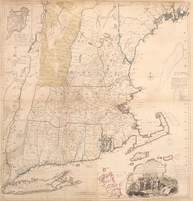
Auction 164, Lot 164
Subject: Colonial New England United States
Jefferys, Thomas
A Map of the Most Inhabited Part of New England, Containing the Provinces of Massachusets Bay and New Hampshire, with the Colonies of Conecticut and Rhode Island..., 1774
Size: 39.2 x 40.9 inches (99.6 x 103.9 cm)
Estimate: $4,000 - $5,000
Influential Map of New England
Sold for: $3,000
Closed on 9/13/2017
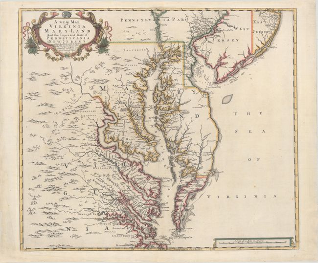
Auction 164, Lot 169
Subject: Colonial Mid-Atlantic United States
Browne/Senex
A New Map of Virginia Mary-land and the Improved Parts of Pennsylvania & New Jersey..., 1719
Size: 21.9 x 19.1 inches (55.6 x 48.5 cm)
Estimate: $5,500 - $6,500
Map of Chesapeake Bay Based on Landmark Herrman Map
Unsold
Closed on 9/13/2017
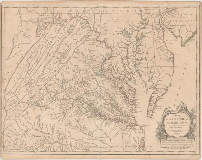
Auction 164, Lot 170
Subject: Colonial Mid-Atlantic United States
Robert de Vaugondy, Didier
Carte de la Virginie et du Maryland Dressee sur la Grande Carte Angloise de Mrs. Josue Fry et Pierre Jefferson..., 1755
Size: 25.4 x 19.1 inches (64.5 x 48.5 cm)
Estimate: $1,900 - $2,200
An Essential Map of Virginia and Maryland
Sold for: $1,000
Closed on 9/13/2017
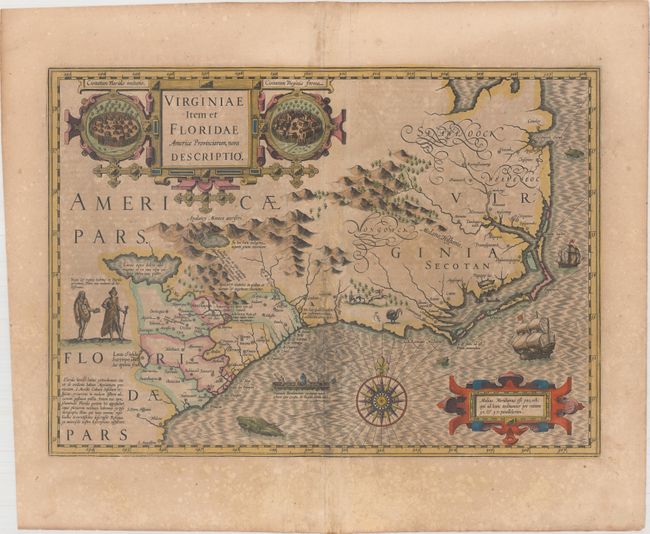
Auction 164, Lot 177
Subject: Colonial Southeast United States
Hondius, Jodocus
Virginiae Item et Floridae Americae Provinciarum, Nova Descriptio, 1619
Size: 19.1 x 13.5 inches (48.5 x 34.3 cm)
Estimate: $1,600 - $1,900
A Seminal Map of the Southeast and Early American Cartography - Full Original Color
Sold for: $1,200
Closed on 9/13/2017
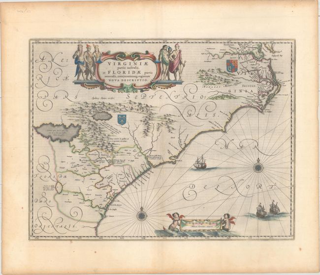
Auction 164, Lot 178
Subject: Colonial Southeast United States
Blaeu, Willem
Virginiae Partis Australis, et Floridae Partis Orientalis, Interjacentiumq Regionum Nova Descriptio, 1642
Size: 20 x 15.3 inches (50.8 x 38.9 cm)
Estimate: $1,400 - $1,700
Blaeu's Decorative Map of the Southeast in Full Original Color
Sold for: $700
Closed on 9/13/2017
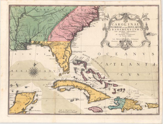
Auction 164, Lot 180
Subject: Colonial Southeast United States, Bahamas & Greater Antilles
Seligmann, Johann Michael
Carolinae Floridae nec non Insularum Bahamensium cum Partibus Adjacendibus Delineatio ad Exemplar Londinense in Lucem Edita, 1755
Size: 23 x 16.8 inches (58.4 x 42.7 cm)
Estimate: $5,000 - $6,500
German Edition of Catesby's Scarce and Important Map of the Southeastern United States
Unsold
Closed on 9/13/2017
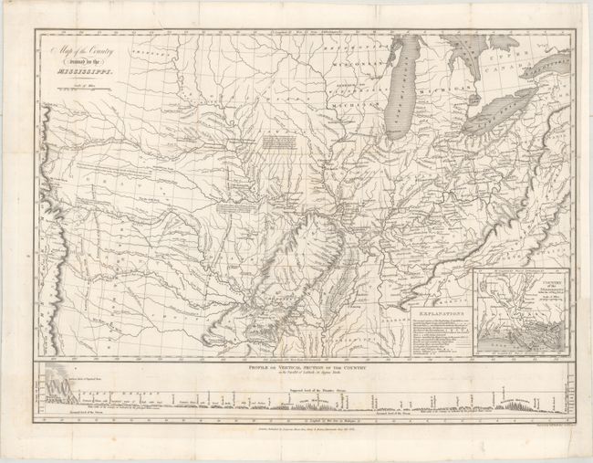
Auction 164, Lot 193
Subject: Central United States
Long, Stephen H. (Col.)
Map of the Country Drained by the Mississippi, 1823
Size: 20.2 x 14.8 inches (51.3 x 37.6 cm)
Estimate: $1,500 - $1,800
Long's Important Map of the American West
Sold for: $1,100
Closed on 9/13/2017
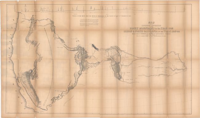
Auction 164, Lot 205
Subject: Western United States
Fremont/Preuss
Map of an Exploring Expedition to the Rocky Mountains in the Year 1842 and to Oregon & North California in the Years 1843-44 [with] Report of The Exploring Expedition to the Rocky Mountains…, 1845
Size: 51 x 30.5 inches (129.5 x 77.5 cm)
Estimate: $800 - $1,100
Fremont's Large Map of the American West
Sold for: $500
Closed on 9/13/2017
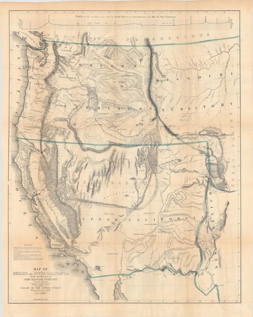
Auction 164, Lot 208
Subject: Western United States
Fremont/Preuss
Map of Oregon and Upper California from the Surveys of John Charles Fremont and Other Authorities, 1848
Size: 26.7 x 33.1 inches (67.8 x 84.1 cm)
Estimate: $1,500 - $1,800
Fremont's Map of the American West
Sold for: $1,100
Closed on 9/13/2017
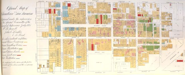
Auction 164, Lot 239
Subject: San Francisco, California
[Map in Book] Official Map of Chinatown in San Francisco... [Bound in] San Francisco Municipal Report for the Fiscal Year 1884-85, Ending June 30, 1885, 1885
Size: 20.8 x 8.1 inches (52.8 x 20.6 cm)
Estimate: $500 - $650
Features a Nefarious Chinatown Map
Sold for: $1,000
Closed on 9/13/2017
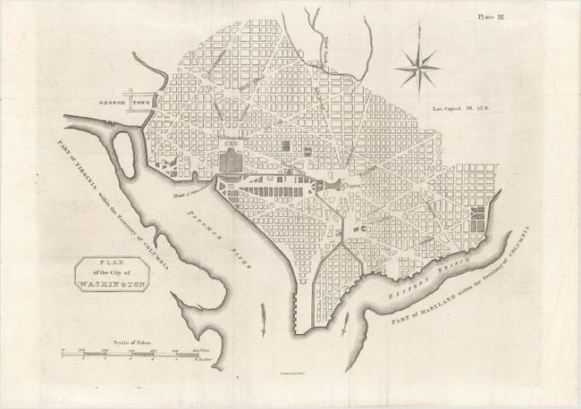
Auction 164, Lot 249
Subject: Washington, D.C.
Plan of the City of Washington, 1805
Size: 10.6 x 8.3 inches (26.9 x 21.1 cm)
Estimate: $1,600 - $1,900
Rare Second Scottish Plan of DC
Unsold
Closed on 9/13/2017
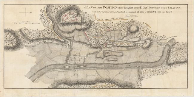
Auction 164, Lot 306
Subject: Colonial New York, Revolutionary War
Faden, William
Plan of the Position which the Army under Lt. Genl. Burgoine Took at Saratoga on the 10th of September 1777..., 1780
Size: 18.8 x 8.5 inches (47.8 x 21.6 cm)
Estimate: $1,100 - $1,400
Important Revolutionary War Map
Sold for: $950
Closed on 9/13/2017
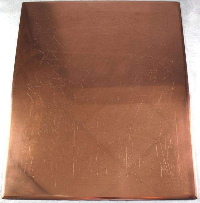
Auction 164, Lot 336
Subject: Central Virginia
U.S. Geological Survey (USGS)
[Lot of 4] [3 Copper Plates of Doswell, VA] [and Map] Virginia. Doswell Quadrangle, 1918
Size: 21 x 17 inches (53.3 x 43.2 cm)
Estimate: $1,000 - $1,500
Original, One-of-a-Kind USGS Copper Plate Set
Sold for: $600
Closed on 9/13/2017
104 lots
Page 1 of 3