Catalog Archive
Auction 164, Lot 163

One of the Earliest Obtainable Sea Charts of the New England Coast

"Pas-Kaart vande Zee Kusten inde Boght van Niew Engeland Tusschen de Staaten Hoek en C. de Sable", Keulen, Johannes van

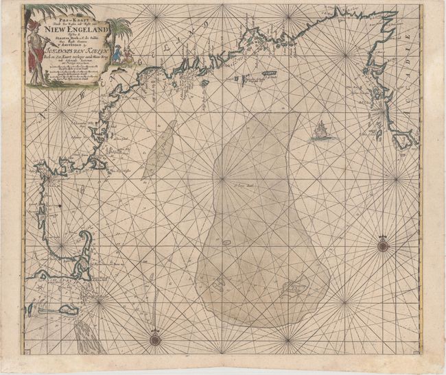
Subject: Colonial New England United States

Period: 1702 (circa)

Publication: De Niewe Groot Lichtende Zee-Fakkel

Color: Hand Color

Size:
23.3 x 20.3 inches
59.2 x 51.6 cm
Download High Resolution Image
(or just click on image to launch the Zoom viewer)

This is one of the earliest obtainable sea charts of the New England coast from this famous Dutch pilot book, which was produced during the period of Dutch dominance as a mercantile and shipping power. It covers the coast from Nova Scotia to Cape Cod and Nantucket. The rendering of Cape Cod is very detailed for the period, complete with soundings, shoals and navigational hazards. Offshore the chart is dominated by St. George's Bank - one of the prime cod fisheries of the region. It is embellished with rhumb lines, compass roses, a sailing ship and a large title cartouche featuring natives, a Dutch trader and incongruous palm trees. This is the fourth state, with a new shoal extending southwest from Cape Sable.

References: Burden #586; McCorkle #684.2.

Condition: A

A dark impression with light printer's ink residue and several minor professional repairs in the blank margins.

Estimate: $2,000 - $2,300

Sold for: $1,500

Closed on 9/13/2017

Archived