Subject: Colonial New England United States
Period: 1774 (dated)
Publication:
Color: Hand Color
Size:
39.2 x 40.9 inches
99.6 x 103.9 cm
Thomas Jefferys was one of the most important English map publishers of the 18th century. His work included prints and maps of locations around the world, but his most notable maps are of North America and the West Indies. He began his career in the map trade in the early 1730s, working as an engraver for a variety of London publishers, and eventually setting up his own shop. In 1746, he was appointed Geographer to the Prince of Wales, and in 1760 he became Geographer to the King. These titles granted access to manuscripts and cartographic information held by the government. In the early 1760s he embarked on an ambitious project to produce a series of English county maps based on new surveys, but ran out of money and filed for bankruptcy in 1766. He then partnered with London publisher Robert Sayer, who reissued many of Jefferys plates and continued to issue new editions after Jefferys' death in 1771. Jefferys' American Atlas and the accompanying West-India Atlas, published post posthumously, are considered his most important cartographic works.
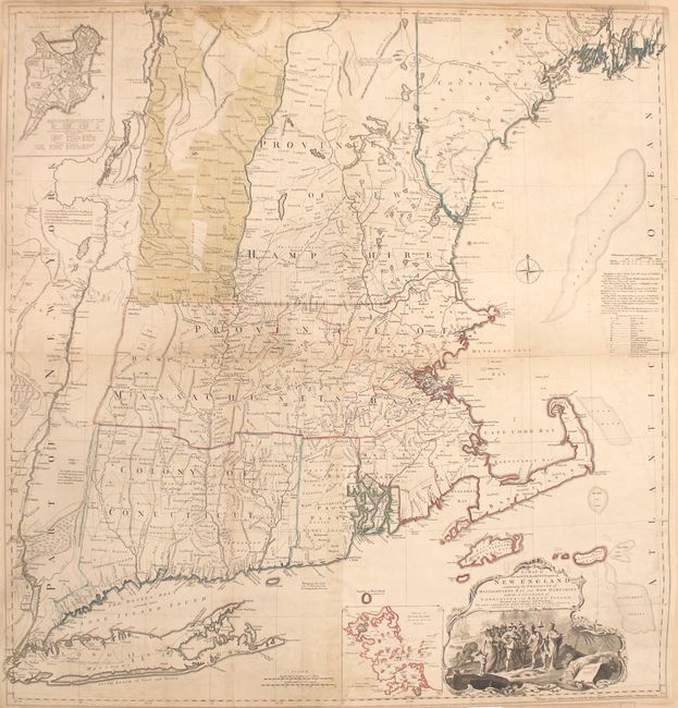
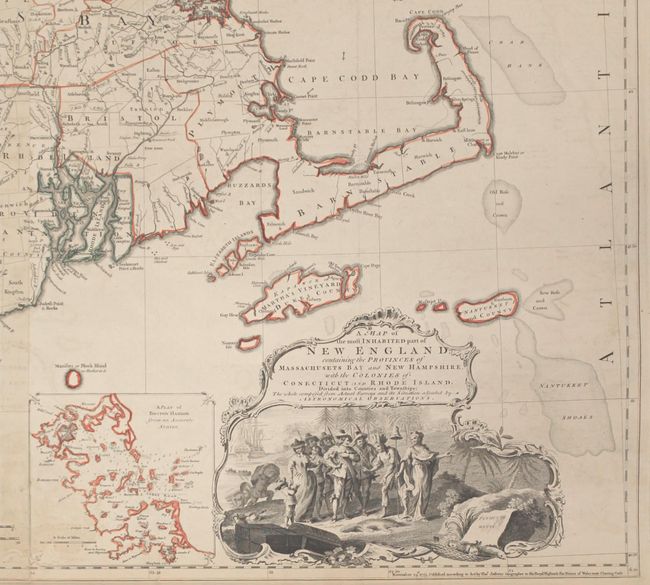
This is the fifth state of Jefferys' celebrated large scale map of New England. The map was first issued in 1755, at the beginning of the French and Indian War, and it became the most influential map of the region for the next several decades. The map was compiled by Bradock Mead (alias John Green) from influential contemporary sources, primarily Plan of the British Dominions of New England in North America (1753) by Dr. William Douglass. Credit is given to each of the surveys used in a table at right center, although Douglass' map is strangely omitted from the list. Jefferys' map represents the first widely disseminated, large-format depiction of the region and is a significant improvement over the Douglass map, in part because of the additional territory covered and almost certainly the additional information which was likely available to Jefferys and Mead in the several years following the issue of the Douglass map. The map shows villages, towns, roads, counties, watershed, mountains and topography, and information along the coast, including islands and bays, and much more. There are two insets: "A Plan of Boston Harbor" and "A Plan of the Town of Boston." Issued on four sheets, joined.
References: McCorkle #755.19; Pritchard & Taliaferro #35; Stevens & Tree (MCC-39) #33(e).
Condition: B+
Light soiling and offsetting with some toning along the joints. There are short splits along the centerfolds of the sheets at top and bottom that have been archivally repaired.