Showing Featured Lots(remove filter)
Showing results for:Auction 163
Catalog Archive
79 lots
Page 1 of 2
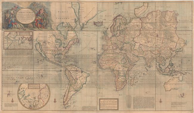
Auction 163, Lot 6
Subject: World
Moll, Herman
A New & Correct Map of the Whole World Shewing ye Situation of Its Principal Parts. Viz the Oceans, Kingdoms, Rivers, Capes, Ports, Mountains, Woods, Trade-Winds, Monsoons, Variations of ye Compass, Climats, &c..., 1719
Size: 47.8 x 27.7 inches (121.4 x 70.4 cm)
Estimate: $4,750 - $6,000
Moll's Large-Scale Map of the World
Sold for: $3,500
Closed on 6/14/2017
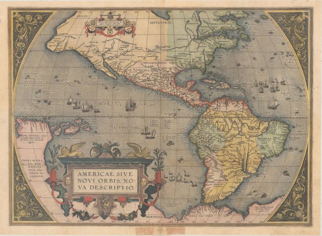
Auction 163, Lot 11
Subject: Western Hemisphere - America
Ortelius, Abraham
Americae sive Novi Orbis, Nova Descriptio, 1587
Size: 19.1 x 13.9 inches (48.5 x 35.3 cm)
Estimate: $4,750 - $6,000
Ortelius' Influential Map of the New World
Sold for: $3,125
Closed on 6/14/2017
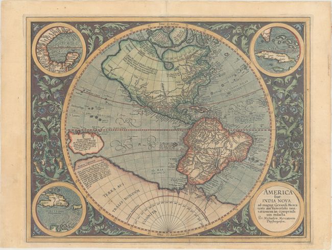
Auction 163, Lot 13
Subject: Western Hemisphere - America
Mercator/Hondius
America sive India Nova, ad Magnae Gerardi Mercatoris aui Universalis Imitationem in Compendium Redacta, 1606
Size: 18.1 x 14.5 inches (46 x 36.8 cm)
Estimate: $3,500 - $4,500
Mercator's Foundation Map for the Americas
Sold for: $2,350
Closed on 6/14/2017
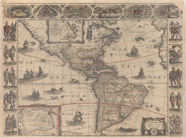
Auction 163, Lot 14
Subject: Western Hemisphere - America
Hondius/Jansson
America Noviter Delineata, 1638
Size: 21.9 x 16.3 inches (55.6 x 41.4 cm)
Estimate: $4,000 - $5,000
Jansson's Rare Carte-a-Figures Map of the Americas
Sold for: $3,000
Closed on 6/14/2017
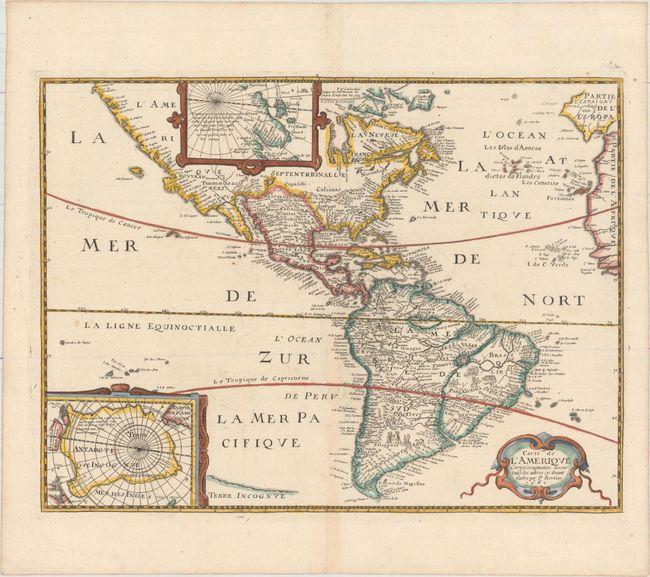
Auction 163, Lot 15
Subject: Western Hemisphere - America
Bertius/Tavernier
Carte de l'Amerique Corrigee et Augmentee; Dessus Toutes les Aultres cy Devant Faictes par P. Bertius, 1661
Size: 14.4 x 10.8 inches (36.6 x 27.4 cm)
Estimate: $1,500 - $1,800
Rare Derivative of Hondius' Influential Map
Unsold
Closed on 6/14/2017
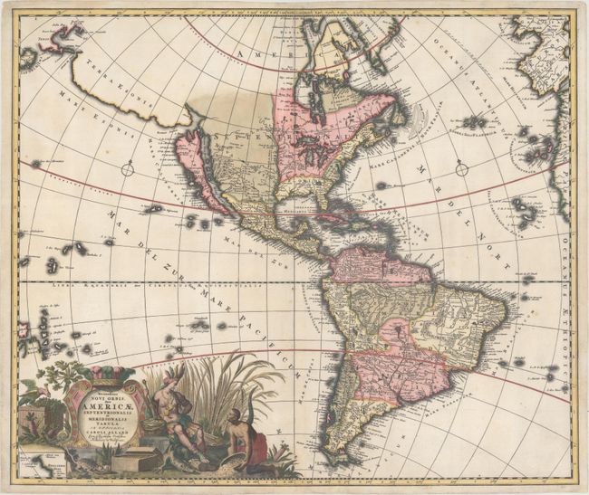
Auction 163, Lot 19
Subject: Western Hemisphere - America
Allard, Carel
Recentissima Novi Orbis, sive Americae Septentrionalis et Meridionalis Tabula, 1697
Size: 23.2 x 19.6 inches (58.9 x 49.8 cm)
Estimate: $1,800 - $2,100
Allard's Elaborate Map of the Western Hemisphere
Sold for: $1,300
Closed on 6/14/2017
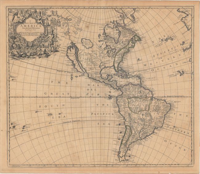
Auction 163, Lot 20
Subject: Western Hemisphere - America
Senex, John
A New Map of America from the Latest Observations, 1719
Size: 22.1 x 19.2 inches (56.1 x 48.8 cm)
Estimate: $1,200 - $1,500
Fascinating Map of the Americas with Unusual Features
Unsold
Closed on 6/14/2017
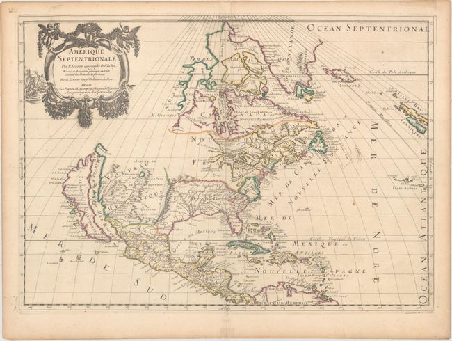
Auction 163, Lot 25
Subject: Colonial North America
Sanson/Mariette
Amerique Septentrionale par N. Sanson..., 1669
Size: 21.9 x 15.6 inches (55.6 x 39.6 cm)
Estimate: $2,400 - $3,000
Important Map for Great Lakes Collectors
Unsold
Closed on 6/14/2017
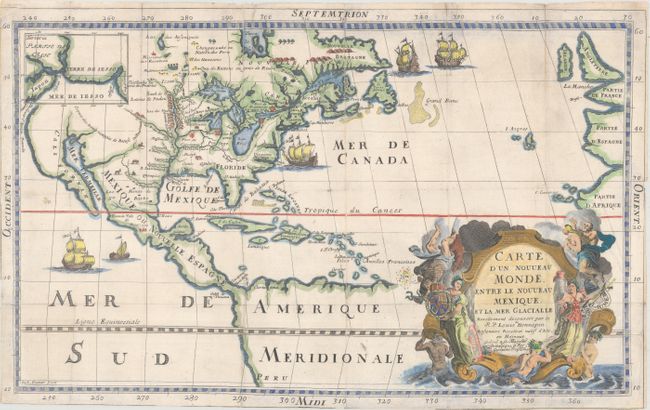
Auction 163, Lot 27
Subject: Colonial North America
Hennepin, Louis de (Fr.)
Carte d'un Nouveau Monde, Entre le Nouveau Mexique, et la Mer Glacialle, 1698
Size: 18.4 x 11.5 inches (46.7 x 29.2 cm)
Estimate: $2,750 - $3,500
Hennepin's Important, Updated Map of North America
Sold for: $1,600
Closed on 6/14/2017
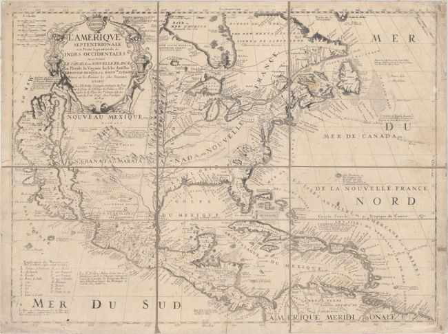
Auction 163, Lot 29
Subject: Colonial North America
Coronelli/Nolin
L'Amerique Septentrionale, ou la Partie Septentrionale des Indes Occidentales ou se Trouve le Canada ou Nouvelle France la Floride la Virginie les Isles Antilles..., 1704
Size: 23.3 x 17.6 inches (59.2 x 44.7 cm)
Estimate: $2,750 - $3,500
Nolin's Spectacular Version of Coronelli's Map of North America
Unsold
Closed on 6/14/2017
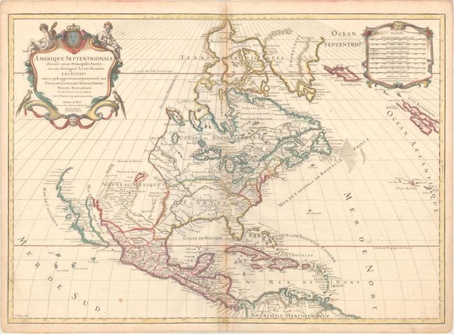
Auction 163, Lot 30
Subject: Colonial North America
Sanson/Jaillot
Amerique Septentrionale Divisee en ses Principales Parties, ou sont Distingues les uns des Autres les Estats..., 1719
Size: 25.3 x 18 inches (64.3 x 45.7 cm)
Estimate: $1,400 - $1,700
Sanson/Jaillot's Map of North America
Unsold
Closed on 6/14/2017
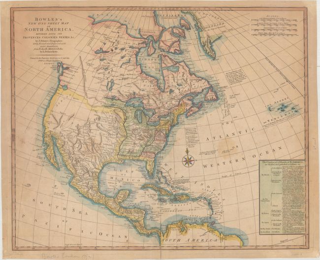
Auction 163, Lot 32
Subject: North America
Palairet/Delarouchette
Bowles's New One-Sheet Map of North America, Divided into It's Provinces, Colonies, States, &c., 1792
Size: 22.8 x 18.6 inches (57.9 x 47.2 cm)
Estimate: $1,500 - $1,800
Rare Map Showing Colonial Possessions and Interesting Geography West of the Mississippi River
Sold for: $650
Closed on 6/14/2017
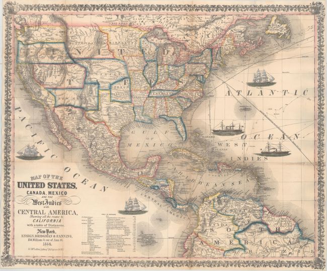
Auction 163, Lot 37
Subject: North America
Ensign, Bridgman & Fanning
Map of the United States, Canada, Mexico and the West Indies with Central America, Showing All the Routes to California with a Table of Distances, 1854
Size: 26 x 21.7 inches (66 x 55.1 cm)
Estimate: $1,800 - $2,100
Decorative Map Published During the California Gold Rush
Sold for: $1,200
Closed on 6/14/2017
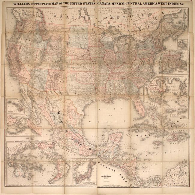
Auction 163, Lot 38
Subject: North America
Williams' Copper-Plate Map of the United States, Canada, Mexico, Central America, West Indies &c., 1876
Size: 63.1 x 61.9 inches (160.3 x 157.2 cm)
Estimate: $1,900 - $2,200
Rare Wall Map of North America
Unsold
Closed on 6/14/2017
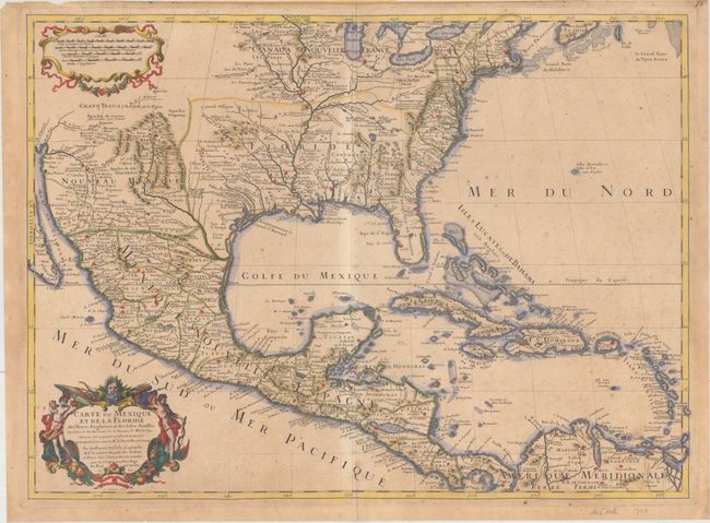
Auction 163, Lot 40
Subject: Colonial Eastern North America & West Indies
Delisle, Guillaume
Carte du Mexique et de la Floride des Terres Angloises et des Isles Antilles du Cours et des Environs de la Riviere de Mississipi..., 1703
Size: 25.6 x 18.7 inches (65 x 47.5 cm)
Estimate: $3,500 - $5,000
Rare First Issue of Landmark in American Cartography - First Printed Map to Accurately Depict the Mouth of the Mississippi River
Sold for: $2,500
Closed on 6/14/2017
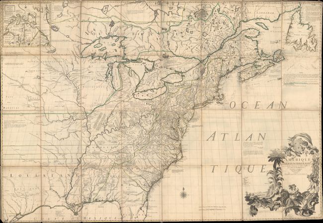
Auction 163, Lot 41
Subject: Colonial Eastern North America & West Indies
Popple/Covens & Mortier
A Map of the British Empire in America with the French, Spanish and Hollandish Settlements Adjacent Thereto by Henry Popple, 1741
Size: 19 x 19.4 inches (48.3 x 49.3 cm)
Estimate: $2,750 - $3,500
Index Sheet of Popple's Map
Sold for: $2,400
Closed on 6/14/2017
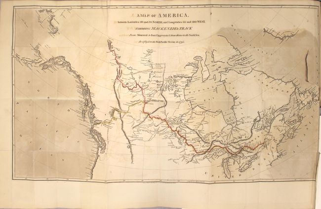
Auction 163, Lot 46
Subject: Canada
Mackenzie, Alexander
Voyages from Montreal, on the River St. Laurence, Through the Continent of North America, to the Frozen and Pacific Oceans; in the Years 1789 and 1793..., 1801
Size: 8.6 x 10.9 inches (21.8 x 27.7 cm)
Estimate: $5,500 - $6,500
First Edition of Mackenzie's Famous Account
Sold for: $4,000
Closed on 6/14/2017
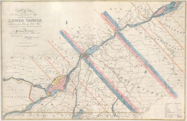
Auction 163, Lot 48
Subject: Eastern Canada, Quebec
Lay, Amos
A New Correct Map of the Seat of War in Lower Canada Protracted from Hollands Large Map Compiled from Actual Survey Made by Order of the Provincial Government..., 1814
Size: 33.1 x 21.6 inches (84.1 x 54.9 cm)
Estimate: $1,600 - $2,000
Lay's Update to Samuel Holland's Map
Unsold
Closed on 6/14/2017
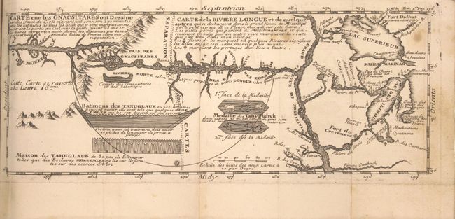
Auction 163, Lot 49
Subject: Colonial United States & Canada, Exploration, River Longue
Lahontan, Louis Armand, Baron de
[2 Volumes] Nouveaux Voyages de Mr Le Baron de Lahontan, dans l'Amerique Septentrionale... [and] Memoires de l'Amerique Septentrionale, ou la Suite des Voyages..., 1704-09
Size: 4 x 6.9 inches (10.2 x 17.5 cm)
Estimate: $1,400 - $1,700
Includes the Reduced, First State of Lahontan's Influential Map Depicting "Riviere Longue"
Sold for: $1,600
Closed on 6/14/2017
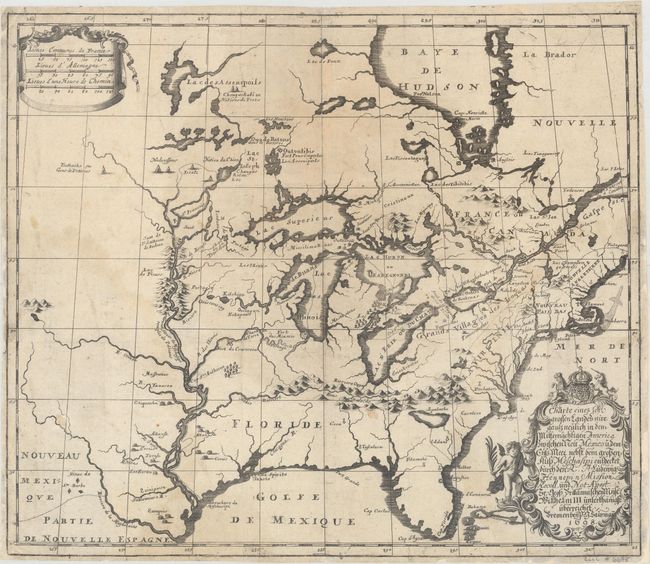
Auction 163, Lot 53
Subject: Colonial Eastern United States & Canada
Hennepin, Louis de (Fr.)
Charte eines sehr Grossen Landes nur Gantz Neulich in dem Mitternachtigen America..., 1698
Size: 16.9 x 14.5 inches (42.9 x 36.8 cm)
Estimate: $2,200 - $2,500
German Edition of Hennepin's Map of Eastern North America
Sold for: $1,500
Closed on 6/14/2017
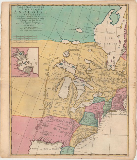
Auction 163, Lot 54
Subject: Colonial Eastern United States & Canada
Mortier, Pierre
Carte Nouvelle de l'Amerique Angloise Contenant la Virginie, Mary-Land, Caroline, Pensylvania Nouvelle Iorck. N: Iarsey N: France, et les Terres Nouvellement Decouerte..., 1700
Size: 18.3 x 23.3 inches (46.5 x 59.2 cm)
Estimate: $1,600 - $2,000
A Map Showing Fascinating Geographic Misconceptions
Sold for: $1,600
Closed on 6/14/2017
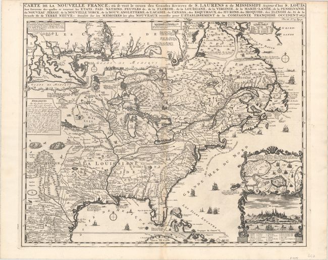
Auction 163, Lot 55
Subject: Colonial Eastern United States & Canada
Chatelain, Henry Abraham
Carte de la Nouvelle France, ou se voit le Cours des Grandes Rivieres de S. Laurens & de Mississipi Aujour d'hui S. Louis, aux Environs des-quelles se Trouvent les Etats, Pais, Nations, Peuples &c..., 1719
Size: 19.3 x 16.6 inches (49 x 42.2 cm)
Estimate: $2,500 - $3,250
One of the Most Informative 18th Century Maps of the French Possessions in North America
Sold for: $1,400
Closed on 6/14/2017
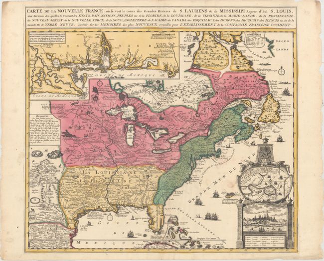
Auction 163, Lot 56
Subject: Colonial Eastern United States & Canada
Fer, Nicolas de
Carte de la Nouvelle France, ou se voit le Cours des Grandes Rivieres de S. Laurnes & de Mississipi Aujour d'hui S. Louis, aux Environs Des-quelles se Trouvent les Etats, Pais, Nations, Peuples, &c..., 1719
Size: 21.7 x 19.6 inches (55.1 x 49.8 cm)
Estimate: $2,300 - $2,750
Striking Map of French Colonial Possessions
Sold for: $1,700
Closed on 6/14/2017
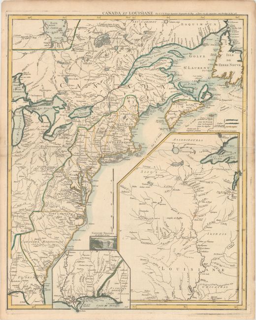
Auction 163, Lot 57
Subject: Colonial Eastern United States & Canada
Le Rouge, George Louis
Canada et Louisiane, 1755
Size: 19.6 x 24.3 inches (49.8 x 61.7 cm)
Estimate: $2,000 - $2,300
Uncommon French & Indian War Map
Sold for: $1,500
Closed on 6/14/2017
Auction 163, Lot 58
Subject: Colonial Eastern United States & Canada
Mitchell/Le Rouge
Amerique Septentrionale avec les Routes, Distances en Miles, Limites et Etablissements Francois et Anglois..., 1756
Size: 76.1 x 53 inches (193.3 x 134.6 cm)
Estimate: $20,000 - $25,000
First French Edition of Mitchell's Monumental Map
Unsold
Closed on 6/14/2017
Auction 163, Lot 64
Subject: Eastern United States & Canada
Rochefoucald Liancourt, Francois Alexander
[4 Volumes] Travels Through the United States of North America, the Country of the Iroquois, and Upper Canada, in the Years 1795, 1796, and 1797, 1800
Size: 5.4 x 8.6 inches (13.7 x 21.8 cm)
Estimate: $3,000 - $4,000
Features Map Depicting Franklinia and Morgania
Sold for: $2,200
Closed on 6/14/2017
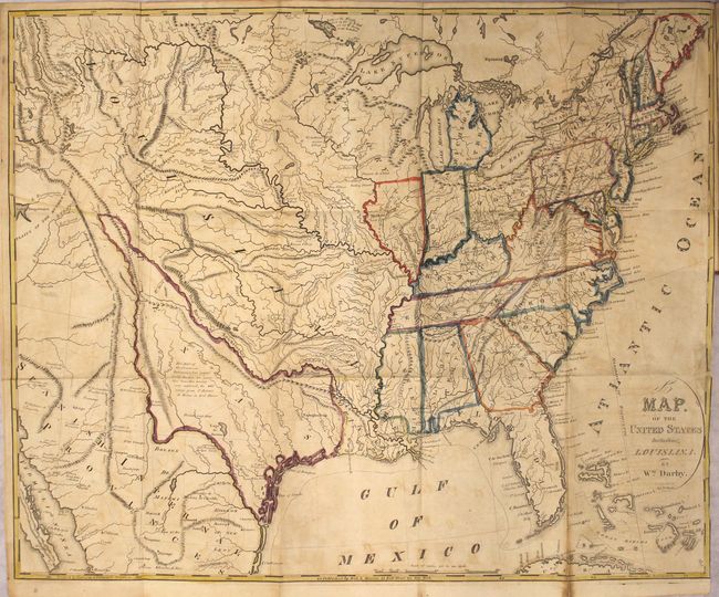
Auction 163, Lot 73
Subject: United States
Darby, William
A Map of the United States Including Louisiana [in] The Emigrant's Guide to the Western and Southwestern States and Territories..., 1818
Size: 5.5 x 8.7 inches (14 x 22.1 cm)
Estimate: $2,000 - $2,300
Darby's Early Emigrant Guide
Sold for: $1,700
Closed on 6/14/2017
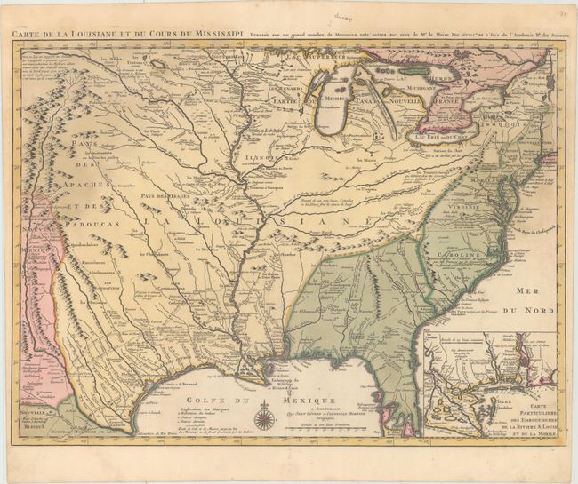
Auction 163, Lot 98
Subject: Colonial Eastern United States, Louisiana Territory
Delisle/Covens & Mortier
Carte de la Louisiane et du Cours du Mississipi Dressee sur un Grand Nombre de Memoires Entr' Autres sur Ceux de Mr. le Maire, 1730
Size: 23.6 x 17.4 inches (59.9 x 44.2 cm)
Estimate: $2,400 - $3,000
Delisle's Influential Map of the Louisiana Territory
Sold for: $1,000
Closed on 6/14/2017
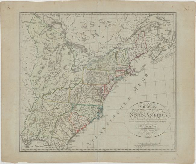
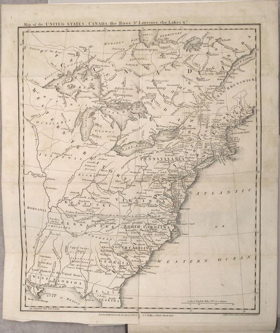
Auction 163, Lot 104
Subject: Eastern United States
Gussefeld, Franz Ludwig
Charte der XV Vereinigten Staaten von Nord-America Nach Murdochischer Projection..., 1800
Size: 20.6 x 18.4 inches (52.3 x 46.7 cm)
Estimate: $1,200 - $1,500
Map Depicting the Proposed State of Franklin
Sold for: $900
Closed on 6/14/2017

Auction 163, Lot 107
Subject: Eastern United States
[2 Volumes] Travels on an Inland Voyage Through the States of New-York, Pennsylvania, Virginia, Ohio, Kentucky and Tennessee..., 1810
Size: 5.3 x 8.5 inches (13.5 x 21.6 cm)
Estimate: $2,200 - $2,500
Early Travel Guide of the Ohio and Mississippi Rivers
Sold for: $1,600
Closed on 6/14/2017
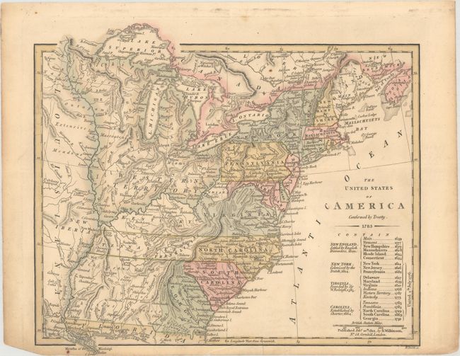
Auction 163, Lot 108
Subject: Eastern United States
Wilkinson, Robert
The United States of America Confirmed by Treaty, 1812
Size: 11.2 x 9.7 inches (28.4 x 24.6 cm)
Estimate: $700 - $850
Early Map of the United States Featuring Franklinia and the Indiana Land Company
Sold for: $700
Closed on 6/14/2017
Auction 163, Lot 109
Subject: Eastern United States
Melish, John
[2 Volumes] Travels in the United States of America, in the Years 1806 & 1807, and 1809, 1810, & 1811; Including an Account of Passages Betwixt America and Britain..., 1812
Size: 5.5 x 8.6 inches (14 x 21.8 cm)
Estimate: $2,300 - $3,000
First Edition of Melish's Map of the United States
Sold for: $1,700
Closed on 6/14/2017
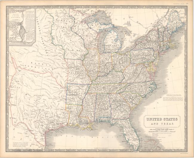
Auction 163, Lot 126
Subject: Eastern United States, Texas
Johnston, Alexander K.
United States and Texas, 1842
Size: 24.3 x 19.6 inches (61.7 x 49.8 cm)
Estimate: $1,100 - $1,400
Highly Detailed British Atlas Map Featuring the Independent Republic of Texas
Sold for: $800
Closed on 6/14/2017
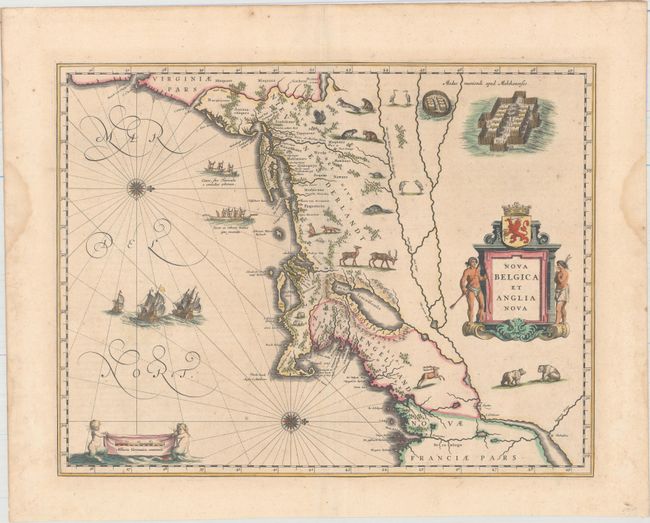
Auction 163, Lot 138
Subject: Colonial New England & Mid-Atlantic United States
Blaeu, Willem
Nova Belgica et Anglia Nova, 1640
Size: 19.9 x 15.3 inches (50.5 x 38.9 cm)
Estimate: $2,750 - $3,500
Important Map of Colonial New England and the Mid-Atlantic in Full Original Color
Sold for: $1,700
Closed on 6/14/2017
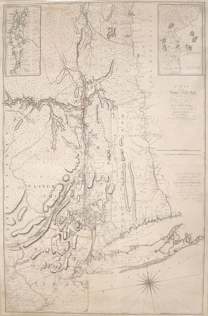
Auction 163, Lot 140
Subject: Colonial New England & Mid-Atlantic United States
Montresor, John
A Map of the Province of New York, with Part of Pensilvania, and New England..., 1775
Size: 36.5 x 56.7 inches (92.7 x 144 cm)
Estimate: $7,000 - $9,000
An Important Revolutionary War Period Map
Unsold
Closed on 6/14/2017
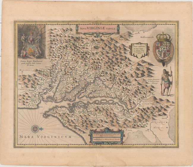
Auction 163, Lot 142
Subject: Colonial Mid-Atlantic United States
Hondius, Henricus
Nova Virginiae Tabula, 1636
Size: 19.5 x 15.1 inches (49.5 x 38.4 cm)
Estimate: $2,000 - $2,300
One of the Most Important 17th Century Maps of the Chesapeake Bay
Unsold
Closed on 6/14/2017
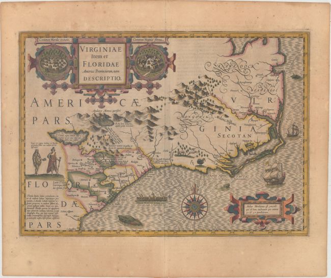
Auction 163, Lot 144
Subject: Colonial Southeastern United States
Hondius, Jodocus
Virginiae Item et Floridae Americae Provinciarum, Nova Descriptio, 1613
Size: 19 x 13.5 inches (48.3 x 34.3 cm)
Estimate: $2,000 - $2,300
A Seminal Map of the Southeast and Early American Cartography - Full Original Color
Sold for: $1,500
Closed on 6/14/2017
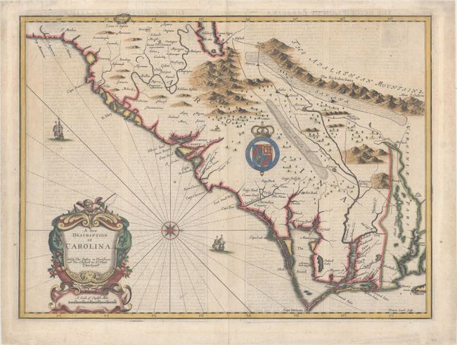
Auction 163, Lot 145
Subject: Colonial Southeastern United States
Speed/Lamb
A New Description of Carolina, 1676
Size: 20.2 x 14.9 inches (51.3 x 37.8 cm)
Estimate: $4,000 - $5,000
Speed's Map of the Carolinas Based Upon the Lords Proprietor's Map
Unsold
Closed on 6/14/2017
Auction 163, Lot 149
Subject: Southeastern United States
Bartram, William
Travels Through North and South Carolina, Georgia, East and West Florida, the Cherokee Country, the Extensive Territories of the Muscogulges or Creek Confederacy, and the Country of the Chactaws..., 1793
Size: 5.5 x 8.3 inches (14 x 21.1 cm)
Estimate: $3,000 - $3,750
Irish Edition of Bartram's Work on the Southeast
Unsold
Closed on 6/14/2017
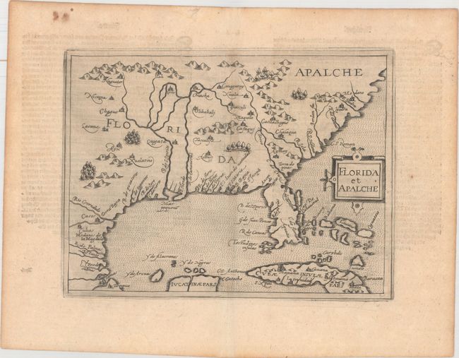
Auction 163, Lot 151
Subject: Colonial Southern United States
Metellus, Natalius Sequanus
Florida et Apalche, 1598
Size: 9.6 x 7.3 inches (24.4 x 18.5 cm)
Estimate: $4,500 - $6,000
One of the Earliest Obtainable Maps of Florida & the Southeast
Unsold
Closed on 6/14/2017
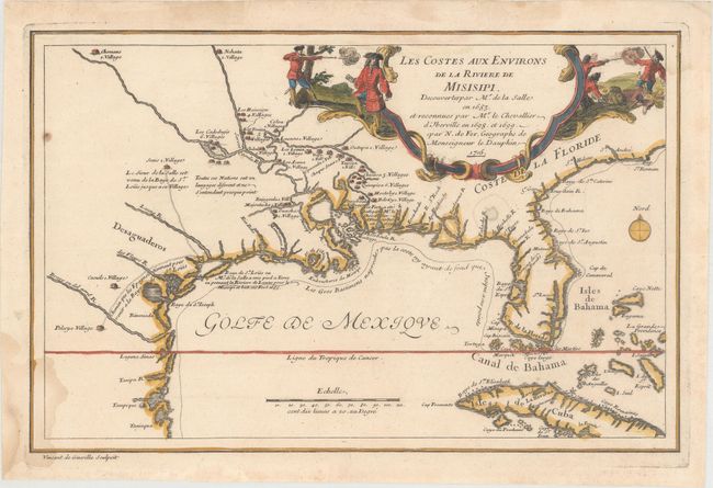
Auction 163, Lot 155
Subject: Colonial Southern United States
Fer, Nicolas de
Les Costes aux Environs de la Riviere de Misisipi. Decouvertes par Mr. de la Salle en 1683. et Reconnues par Mr. le Chevallier d'Jberville en 1698. et 1699, 1705
Size: 13.2 x 8.6 inches (33.5 x 21.8 cm)
Estimate: $950 - $1,200
Landmark Map for Mapping of the Mississippi River
Sold for: $500
Closed on 6/14/2017
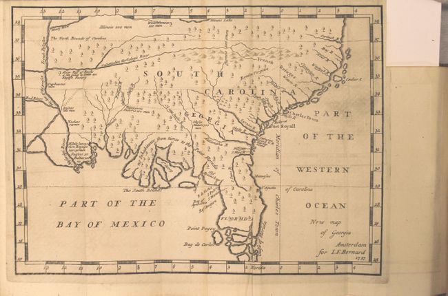
Auction 163, Lot 158
Subject: Colonial Southern United States
Bernard, Jean Frederic
New Map of Georgia [in book] Recueil de Voiages au Nord...Tome Neuvieme, 1737
Size: 10.3 x 7.5 inches (26.2 x 19.1 cm)
Estimate: $1,600 - $1,900
One of the Earliest Published Maps of the English Colony of Georgia
Sold for: $850
Closed on 6/14/2017
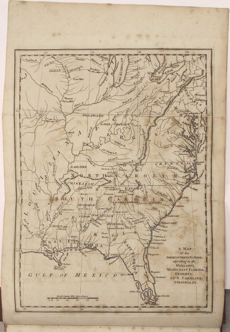
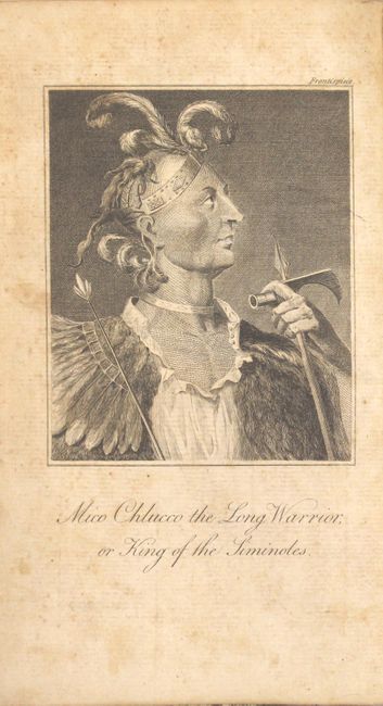
Auction 163, Lot 161
Subject: Colonial Southern United States
[Book with Map] The History of the American Indians; Particularly those Nations Adjoining to the Missisippi, East and West Florida, Georgia, South and North Carolina, and Virginia..., 1775
Size: 9.6 x 12.9 inches (24.4 x 32.8 cm)
Estimate: $4,500 - $5,500
Important History of Native Americans in the Southeast with Map
Unsold
Closed on 6/14/2017
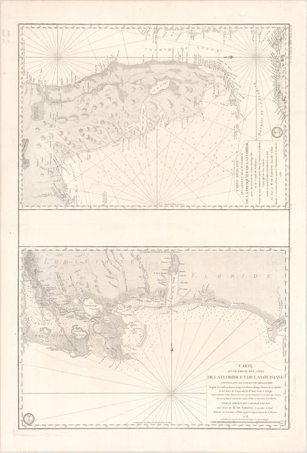
Auction 163, Lot 162
Subject: Colonial Southern United States
Depot de la Marine
Carte d'une Partie des Cotes de la Floride et de la Louisiane... [on sheet with] Carte Reduite des Cotes et de l'Interieur de la Presqu'ile de la Floride..., 1778-80
Size: 23.1 x 34.4 inches (58.7 x 87.4 cm)
Estimate: $3,000 - $4,000
Two Important Revolutionary War Charts
Sold for: $2,100
Closed on 6/14/2017
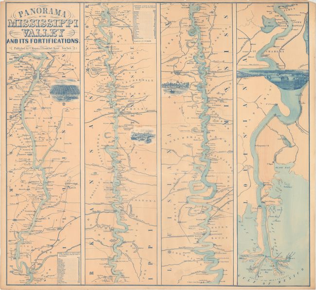
Auction 163, Lot 188
Subject: South Central United States
Magnus, Charles
Panorama of the Mississippi Valley and Its Fortifications, 1863
Size: 25.2 x 23.5 inches (64 x 59.7 cm)
Estimate: $1,300 - $1,600
Desirable Strip-Style Civil War Map of the Mississippi
Sold for: $500
Closed on 6/14/2017
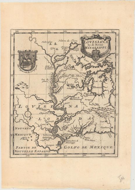
Auction 163, Lot 189
Subject: Colonial Louisiana, Mississippi River
Anon.
Louisiana by de Rivier Missisippi, 1721
Size: 6.1 x 7.1 inches (15.5 x 18 cm)
Estimate: $1,200 - $1,500
Map of the Mississippi River valley Following the Mississippi Bubble Incident
Sold for: $700
Closed on 6/14/2017
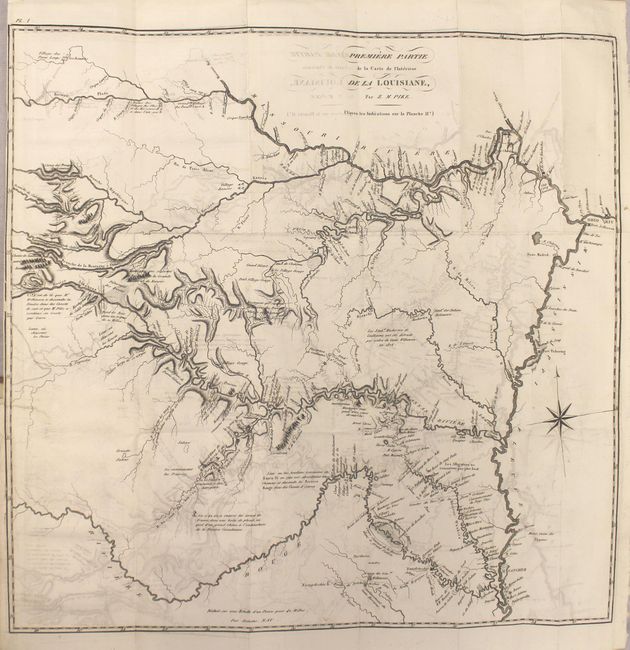
Auction 163, Lot 190
Subject: Central United States
Pike, Zebulon
Voyage au Noveau-Mexique, a la Suite d'une Expedition Ordonnee par le Gouvernement des Etats-Unis, pour Reconnoitre les Sources des Rivieres Arkansas, Kanses, La Plate et Pierre-Jaune..., 1812
Size: 5.3 x 8.3 inches (13.5 x 21.1 cm)
Estimate: $5,000 - $6,500
First French Edition of Pike's Cornerstone Report
Unsold
Closed on 6/14/2017

Auction 163, Lot 210
Subject: Western United States
Fisher, William
New Travels Among the Indians of North America; Being a Compilation, Taken Partly from the Communications Already Published, of Captains Lewis and Clark..., 1812
Size: 4.5 x 7.4 inches (11.4 x 18.8 cm)
Estimate: $2,000 - $2,500
An Unauthorized Account of Lewis & Clark's Expedition
Sold for: $1,000
Closed on 6/14/2017
Auction 163, Lot 211
Subject: Western United States
Gass, Patrick
Journal of the Voyages and Travels of a Corps of Discovery, Under the Command of Capt. Lewis and Capt. Clarke of the Army of the United States..., 1812
Size: 4.6 x 7.3 inches (11.7 x 18.5 cm)
Estimate: $5,500 - $7,000
Fourth Edition of the Earliest First-Hand Narrative of the Lewis & Clark Expedition
Unsold
Closed on 6/14/2017
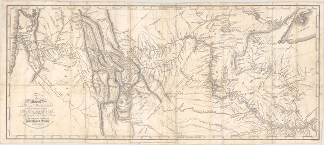
Auction 163, Lot 213
Subject: Western United States
Lewis & Clark
A Map of Lewis and Clark's Track Across the Western Portion of North America, from the Mississippi to the Pacific Ocean, by Order of the Executive of the United States in 1804, 5 & 6 [with] Travels to the Source of the Missouri River..., 1817
Size: 27.5 x 11.8 inches (69.9 x 30 cm)
Estimate: $7,000 - $9,000
London Edition of Lewis & Clark's Famous Map
Sold for: $4,000
Closed on 6/14/2017
79 lots
Page 1 of 2