Subject: Eastern United States & Canada
Period: 1800 (published)
Publication:
Color: Black & White
Size:
5.4 x 8.6 inches
13.7 x 21.8 cm
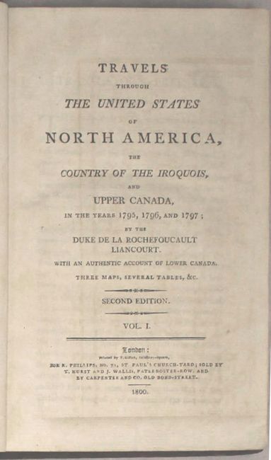
This is the second English edition of Francois Alexander Frederic La Rochefoucald Liancourt's account of his travels in Canada and the United States. A supporter of the French monarchy, La Rochefoucald Liancourt fled to England and then the United States during the French Revolution. He spent 3 years in exile in North America and published an account of his experience upon returning to France in 1799. His work describes in detail the political constitution, natural history, physical geography, agriculture, and the customs of the inhabitants of the United States. Included are three folding maps:
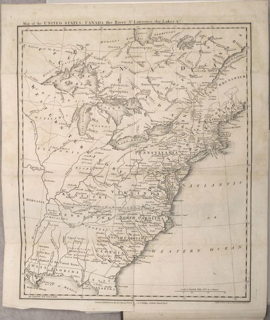
A. Map of the United States, Canada the River St. Lawrence, the Lakes &c. (13.3 x 16"). This great map of the fledgling nation includes numerous areas of interest. In New England, Maine is shown with a truncated northern boundary, reflecting the British view of the border dispute. Georgia's western boundary is the Mississippi River. Florida, at the time a Spanish territory, is divided into East and West, with the notation "Land Claimed by the United States" on the northern boundary on the 31st parallel. The proposed state of Franklinia is located in eastern Tennessee. This 'state' of Franklin was formed in 1784 by a group of westerners, with John Sevier appointed as Governor. Due to some fascinating political intrigue, Franklinia was never recognized by Congress and eventually was re-annexed by North Carolina. The region west of the Mississippi River (present-day Missouri and Arkansas) is named Morgania, which at the time was Spanish territory. In an effort to protect New Orleans and trade on the Mississippi River, the Spanish employed the assistance of an American named Col. George Morgan to establish a colony in a vast tract of land opposite of the mouth of the Ohio River. The colony, also known as New Madrid, lasted but a short while, due to yet more political intrigue and to extensive flooding of the Mississippi. Engraved by Smith & Jones. Condition: Light offsetting and a short binding tear that has been closed on verso with archival tape. (B+)
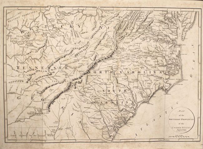
B. Map of the Southern Provinces of the United States (19.8 x 13.5"). This interesting map covers all of the Carolinas with parts of Virginia, Kentucky, Tennessee, and Georgia. Features great detail of early roads and settlements. Between Tennessee and Georgia is a long strip of land labeled United States Territory. This land originally belonged to South Carolina but was ceded back to the United States in 1787. Numerous Indian villages are shown, especially in the region of present-day Alabama. Engraved by John Russell. Condition: A dark impression with scattered foxing and minor offsetting. (B)
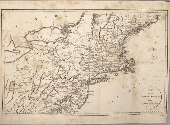
C. Map of the Northern Provinces of the United States (19.8 x 12.6"). This map covers all of the Northeast and Mid-Atlantic, extending south to below Alexandria and west to beyond Wheeling on the Ohio River. Early county development in Pennsylvania is current to 1794, prior to the organization of Greene and Lycoming Counties. The Lands of the Six Nations appear in western New York beside Lake Erie. There is very good detail of roads throughout the region. Engraved by John Russell Jr. Condition: Moderate foxing with light offsetting and a tiny binding tear at right. (B)
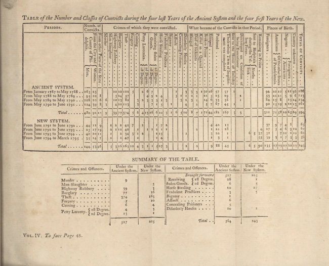
Also included are nine folding tables outlining the number and types of criminal convictions, the types and amounts of exports and imports between the United States and England, and several tables related to the functioning of the government of the United States and each individual state and territory. Octavo, 4 volumes: Pp. xvi, 591, [16]; 523, [16]; 717, [21]; 610, [8]. Hardbound in full leather, gilt tooling on spine with red leather title label.
References: Dotson & Baker (OWA) #14a.1; Howes #L106; Sabin #39057.
Condition: B+
See description above for condition of maps. The text is overall clean and bright with occasional minor toning or foxing. The bindings are sound and the covers show light wear with bumped corners and some small abrasions. The front cover of volume 2 is just beginning to separate. Bookplate for "Crofton" on the front pastedown of each volume.