Subject: Colonial Southeastern United States
Period: 1613 (circa)
Publication: Gerardi Mercatoris - L'Atlas ou Meditations Cosmographiques...
Color: Hand Color
Size:
19 x 13.5 inches
48.3 x 34.3 cm
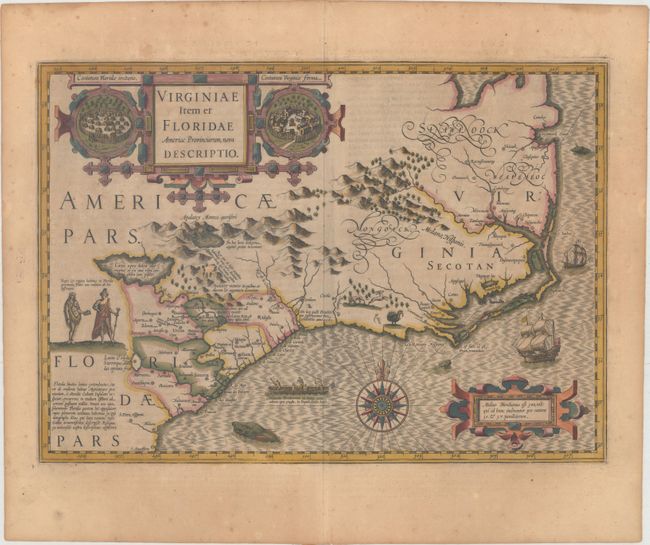
This stunning map was compiled from two of the most important source maps of the early colonial period: John White's Virginia and Jacques le Moyne's Florida. Hondius' map became the prototype map of the region for the first half of the 17th century and continued to influence the cartography of the region until the middle of the 18th century. Largely due to the enormous success of Hondius' Atlas, Le Moyne's erroneous depiction of a large inland lake (Lacus aquae dulcis) from which the R. de May (St. John's River) flows in a southeasterly direction was popularized. Chesapeake Bay, here called Chesepioock Sinus, and the area south towards C.S. Romano Hispanis are shown in their White delineations. The Indian villages of Paquiwok, Croatoan, and Wococon are named in the Outer Banks and several others along the Albemarle and Pamlico Sounds. The map is extensively decorated with depictions of Indian villages incorporated in the title cartouche, a Floridian king and queen and Virginian natives in a canoe taken from De Bry, wildlife including a wild turkey, ships, sea monsters and a superb compass rose. French text on verso, published between 1613-1616.
References: Burden #151; Cumming (SE) #26; Williams & Johnson #3; Van der Krogt (Vol. I) #9400:1A.
Condition: B+
Full original color on a lightly toned sheet of watermarked paper. There is minor foxing primarily in the blank margins and two short edge tears confined to the far blank margins.