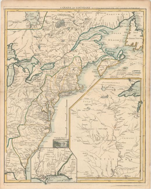
Subject: Colonial Eastern United States & Canada
Period: 1755 (dated)
Publication:
Color: Hand Color
Size:
19.6 x 24.3 inches
49.8 x 61.7 cm
This important map was issued at the outbreak of hostilities in the French and Indian War. The detailed map depicts the entire eastern seaboard from northern Florida to the Strait of Belle Isle, and the Great Lakes region up to Lake Michigan and eastern Lake Superior. The American interests of France, England and Spain are shown in great detail and color-coded. Fort Duquesne is shown in two different places on the map - according to D’Anville and also to Jefferys. A large inset shows the upper Mississippi River valley with the important frontier forts. A smaller inset shows the lower Mississippi and Gulf Coast. A small vignette of Niagara Falls adds further interest to this fascinating map.
This is the second state of the map with two color-coded keys to the right of Nova Scotia identifying the "pretensions" (claims) of both the English and French. Le Rouge later updated the plate in 1777 and retitled it to Theatre de la Guerre en Amerique, and the map also made an appearance in Francois Soules' Histoire des Troubles de l'Amerique Anglaises, published in 1787.
References: McCorkle #755.23; Sellers and Van Ee #33.
Condition: A
A nice impression on a sheet of watermarked paper with a few minor printer's creases and light toning along the sheet edges.