Subject: North America
Period: 1792 (circa)
Publication:
Color: Hand Color
Size:
22.8 x 18.6 inches
57.9 x 47.2 cm
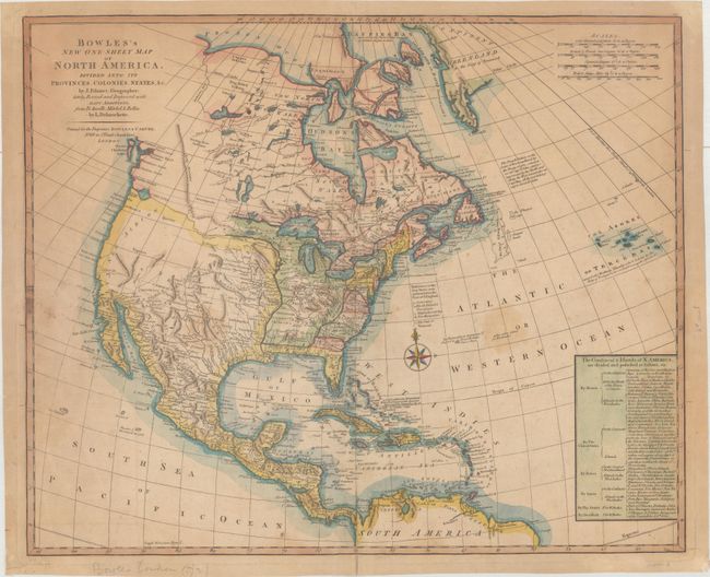
This map was published a decade after the American Revolution and focuses on the new territorial boundaries in North America. A chart at bottom right lists the lands belonging to the United States and the European colonial powers, including Britain, France, Spain, the Dutch Republic, and Denmark. Virginia, North Carolina, South Carolina and Georgia are contained east of the Appalachian Mountains, with the Western Territory extending to the Mississippi River and remaining open-ended in the northwest. The Western Territory is filled with numerous Indian tribes and the preliminary outlines of the states of Kentucky, Tennessee, and Illinois. Ft. Checagou is noted on Lake Michigan. Florida is still under Spanish control and is divided into East and West. The western United States, also under Spanish control, is labeled Louisiana, New Mexico, and New Albion and includes several spurious mountain ranges. The Rocky Mountains are correctly illustrated in northern Canada, but then veer east towards Minnesota north of the R. Oregan, which nearly connects the Mississippi River to the Pacific Ocean via a large bay labeled as the Entrance of Juan de Fuca. The map was created circa 1792 due to the identification of the "state of Vermont" (which had achieved statehood in March 1791) in a key in the Atlantic, yet the fact that Kentucky, which achieved statehood in June 1792, is not yet marked as a state. Another clue to the publication date is the existence of Mackenzies River leading to the Canadian Arctic, based on Alexander Mackenzie's 1789 expedition, yet no sign of his 1792-93 expedition to the Pacific Ocean. Also missing are any references to George Vancouver's expedition to the Pacific northwest from 1792-94.
This map was based on the work of Jean Palairet, with significant updates and improvements by Louis Stanislaw d'Arcy Delarochette based on maps by D'Anville, Mitchell, and Bellin, as noted in the title. Published by Carrington Bowles & Jonathan Carver. This map is similar to Bowles's New Pocket Map of North America..., which is more common.
References:
Condition: B
A nice impression with light toning, moderate soiling, and a 1" centerfold separation at bottom that has been archivally repaired.