Showing Featured Lots(remove filter)
Showing results for:Auction 153
Catalog Archive
78 lots
Page 1 of 2
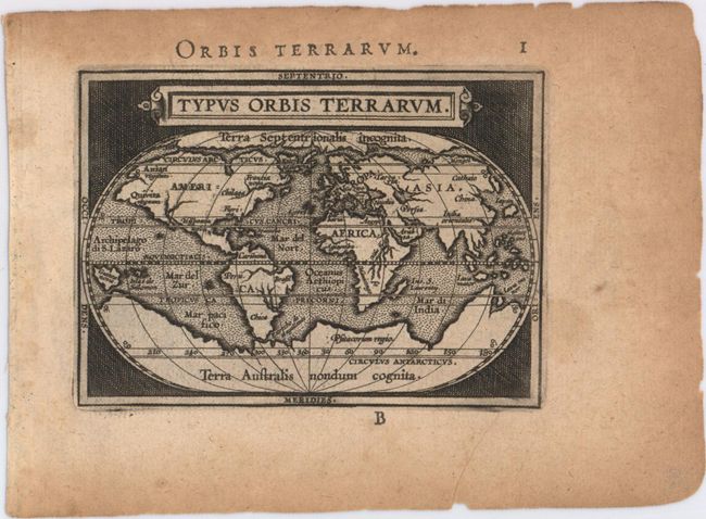
Auction 153, Lot 1
Subject: World & Continents
Ortelius/Galle
[Lot of 5] Typus Orbis Terrarum [and] Americae sive Novi Orbis Nova Descriptio [and] Africa [and] Asia [and] Europa, 1595
Size: 4.3 x 3.1 inches (10.9 x 7.9 cm)
Estimate: $2,000 - $2,300
Matching Set of Miniature World and Continents Based on Ortelius
Sold for: $1,300
Closed on 5/20/2015
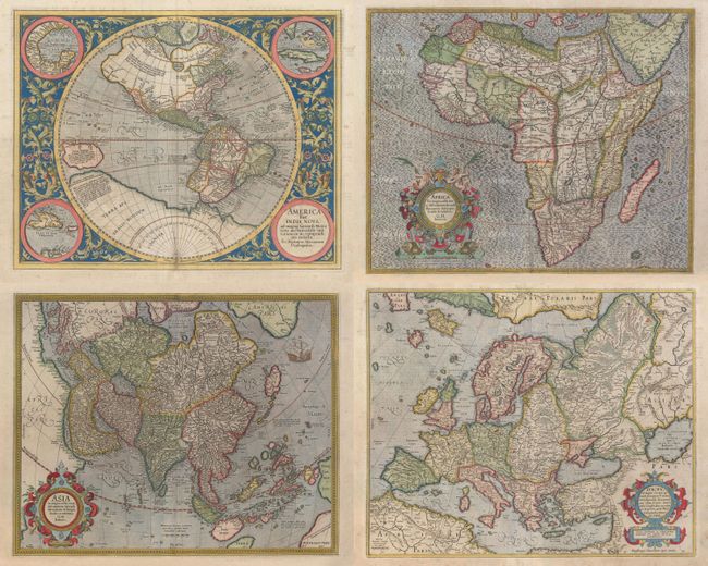
Auction 153, Lot 2
Subject: Continents
Mercator/Hondius
[Lot of 4] America sive India Nova, ad Magnae Gerardi Mercatoris… [and] Africa ex Magna Orbis Terre Descriptione Gerardi Mercatoris [and] Asia ex Magna Orbis Terre Descriptione Gerardi Mercatoris [and] Europa, ad Magnae Europae Gerardi Mercatoris, 1628
Size: See Description
Estimate: $9,000 - $11,000
Matching Set of Continents by Mercator
Sold for: $6,500
Closed on 5/20/2015
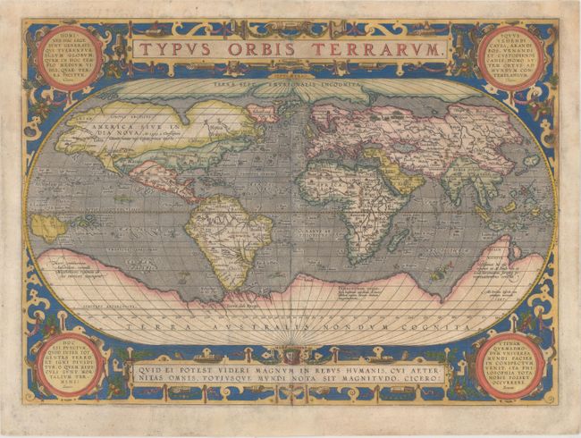
Auction 153, Lot 4
Subject: World
Ortelius, Abraham
Typus Orbis Terrarum, 1587
Size: 19.3 x 13.9 inches (49 x 35.3 cm)
Estimate: $5,500 - $7,000
Ortelius' Third World Map in an Oval Projection
Sold for: $3,750
Closed on 5/20/2015
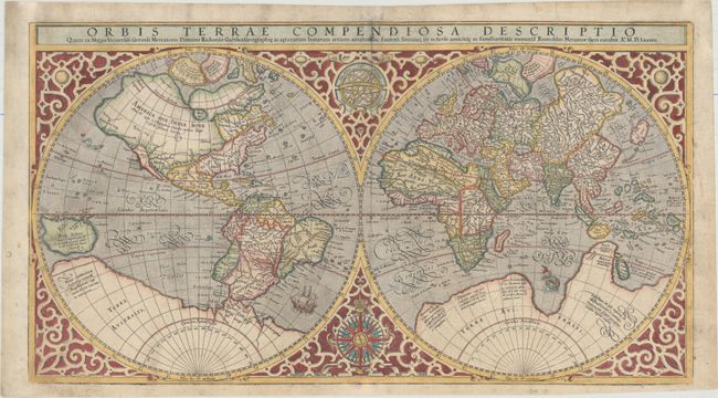
Auction 153, Lot 5
Subject: World
Mercator, Rumold
Orbis Terrae Compendiosa Descriptio quam ex Magna Universali Gerardi Mercatoris..., 1587
Size: 20.8 x 11.4 inches (52.8 x 29 cm)
Estimate: $4,750 - $6,000
Mercator's Double-Hemisphere World Map - Very Early Example
Sold for: $3,500
Closed on 5/20/2015
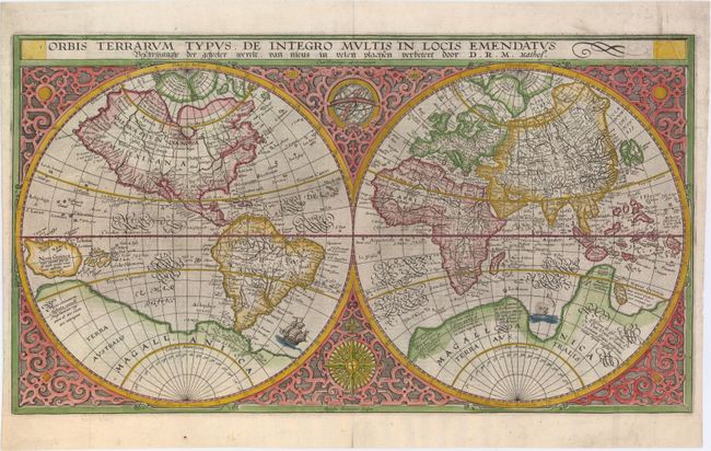
Auction 153, Lot 6
Subject: World
Plancius, Petrus
Orbis Terrarum Typus de Integro Multis in Locis Emendatus..., 1625
Size: 20.3 x 11.2 inches (51.6 x 28.4 cm)
Estimate: $3,250 - $4,000
Plancius' World Map Surrounded by Elegant Strapwork
Sold for: $2,000
Closed on 5/20/2015
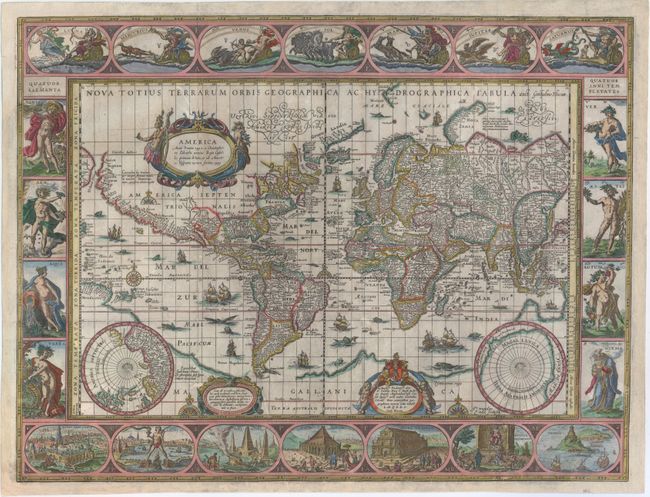
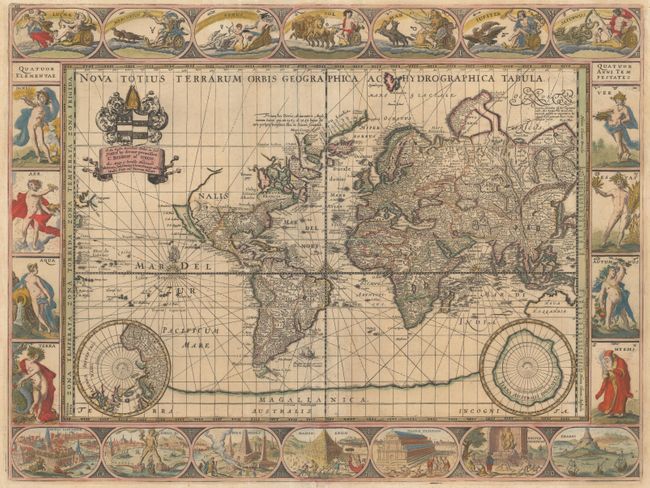
Auction 153, Lot 7
Subject: World
Blaeu, Willem
Nova Totius Terrarum Orbis Geographica ac Hydrographica Tabula, 1630
Size: 21.3 x 16.1 inches (54.1 x 40.9 cm)
Estimate: $8,000 - $9,500
Blaeu's Magnificent Carte-a-Figures World Map with No Text on Verso
Sold for: $5,500
Closed on 5/20/2015
Auction 153, Lot 9
Subject: World
Tavernier, Melchior
[Lot of 2] Carte de l'Amerique Nouvellement Dressee Suivant les Nouvelles Descouvertes... [and] Carte Nouvelle de l'Europe Asie & Afrique..., 1661
Size: 11.8 x 11.8 inches (30 x 30 cm)
Estimate: $3,000 - $3,750
Elegant World Map in Two Separate Hemispheres
Unsold
Closed on 5/20/2015
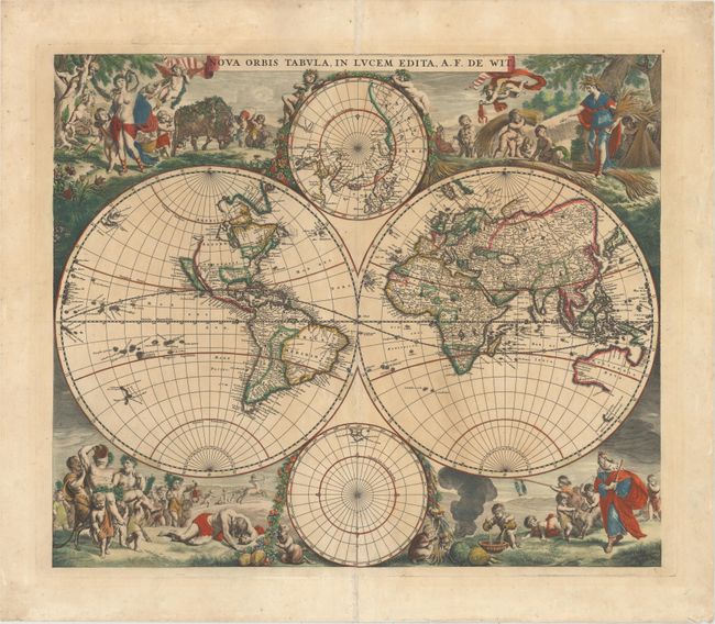
Auction 153, Lot 10
Subject: World
Wit, Frederick de
Nova Orbis Tabula, in Lucem Edita, 1670
Size: 21.8 x 18.3 inches (55.4 x 46.5 cm)
Estimate: $4,750 - $6,000
First State of De Wit's Stunning Double-Hemisphere Map in Original Color
Sold for: $3,500
Closed on 5/20/2015
Auction 153, Lot 11
Subject: World
Danckerts, Justus
Nova Totius Terrarum Orbis Tabula, 1680
Size: 22.8 x 19.2 inches (57.9 x 48.8 cm)
Estimate: $4,000 - $4,750
Danckerts' Decorative Double-Hemisphere Map
Unsold
Closed on 5/20/2015
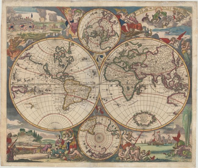
Auction 153, Lot 12
Subject: World
Pitt, Moses
Nova Totius Terrarum Orbis Geographica ac Hydrographica Tabula, 1680
Size: 20.9 x 15.7 inches (53.1 x 39.9 cm)
Estimate: $9,500 - $11,000
Pitt's Rare Carte-a-Figures Map in Full Original Color
Sold for: $5,200
Closed on 5/20/2015
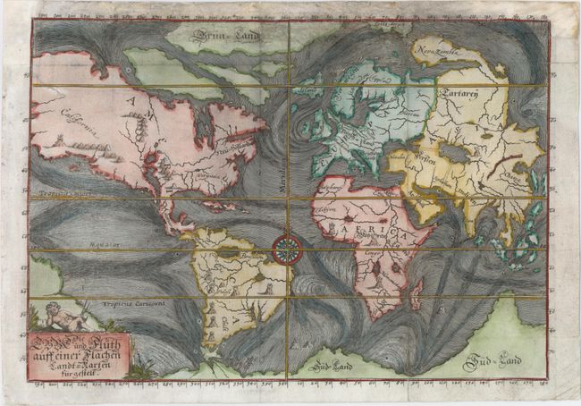
Auction 153, Lot 14
Subject: World
Happel, Everard Werner
Die Ebbe und Fluth auff einer Flachen Landt-Karten Furgestelt, 1687
Size: 11.6 x 8 inches (29.5 x 20.3 cm)
Estimate: $900 - $1,100
One of the Earliest Thematic World Maps
Sold for: $600
Closed on 5/20/2015

Auction 153, Lot 20
Subject: World
Moll, Herman
A New & Correct Map of the Whole World Shewing ye Situation of its Principal Parts…with the Most Remarkable Tracks of the Bold Attempts Which Have Been Made to Find out the North East & Northwest Passages…, 1719
Size: 47.5 x 28 inches (120.7 x 71.1 cm)
Estimate: $5,500 - $6,500
Moll's Large-Scale Map of the World
Sold for: $3,000
Closed on 5/20/2015
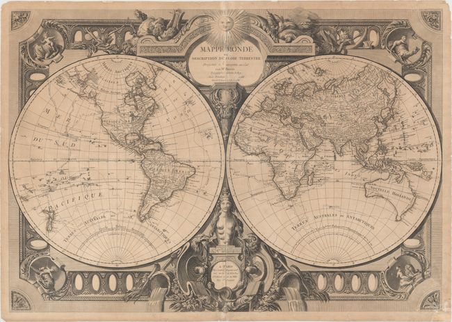
Auction 153, Lot 28
Subject: World
Bonne, Rigobert
Mappe Monde ou Description du Globe Terrestre Projettee & Assujettie au Ciel, 1788
Size: 39.4 x 27.7 inches (100.1 x 70.4 cm)
Estimate: $2,000 - $2,500
Bonne's Large and Elaborate Double-Hemisphere Map
Sold for: $1,500
Closed on 5/20/2015
Auction 153, Lot 34
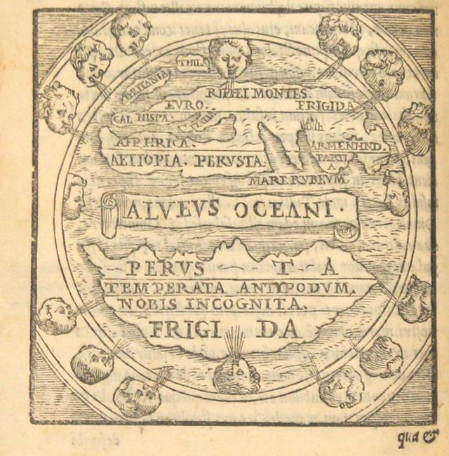
Subject: Ancient World
Macrobius, Ambrosius Aurelius Theodo
Macrobii Ambrosii Aurelii Theodosij, Viri Consularis, & Illustris..., 1565
Size: 4.1 x 6.1 inches (10.4 x 15.5 cm)
Estimate: $1,500 - $1,800
Macrobius' Miniature Ancient World Map
Unsold
Closed on 5/20/2015
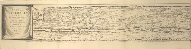
Auction 153, Lot 37
Subject: Ancient World
Jansson, Jan
Tabula Itineraria ex Illustri Peutingerorum Bibliotheca… [in book] Histoire des Grands Chemins de l'Empire Romain, Contenant l'Origine, Progres & Etendue Quasi Incroyable des Chemins Militaires…, 1728
Size: 159.3 x 7.3 inches (404.6 x 18.5 cm)
Estimate: $3,000 - $3,750
Famous Peutinger Table in History of Roman Roads
Sold for: $2,500
Closed on 5/20/2015
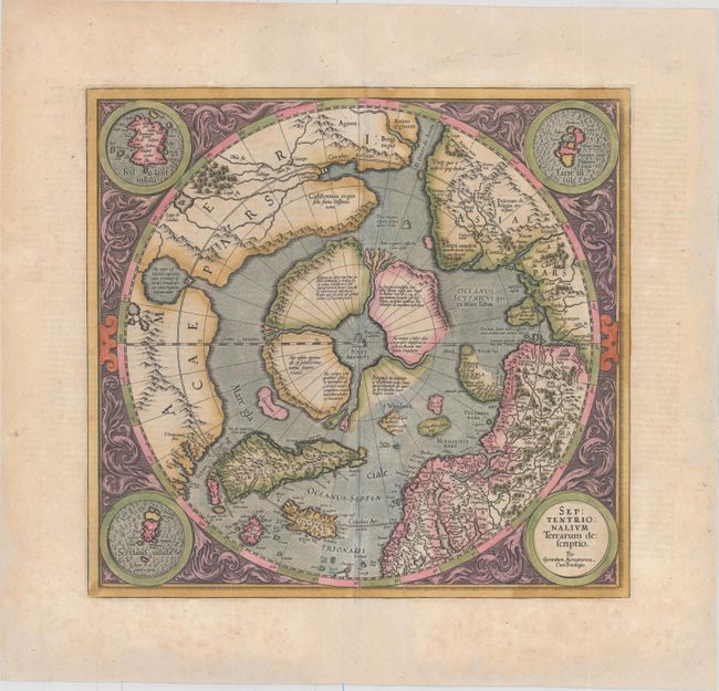
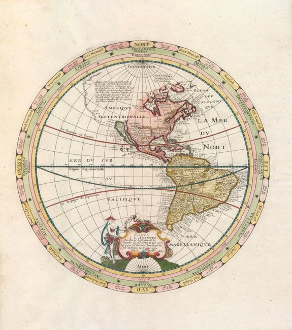
Auction 153, Lot 41
Subject: North Pole
Mercator, Gerard
Septentrionalium Terrarum Descriptio, 1628
Size: 15.5 x 14.5 inches (39.4 x 36.8 cm)
Estimate: $2,200 - $2,500
The First Printed Map Devoted to the Arctic
Sold for: $1,300
Closed on 5/20/2015
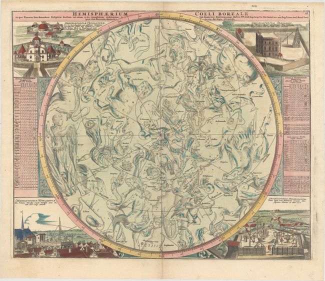
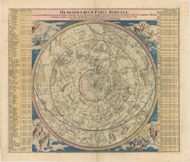
Auction 153, Lot 46
Subject: Celestial
Doppelmayr/Homann
[Lot of 2] Hemisphaerium Coeli Boreale in quo Fixarum Loca Secundum Eclipticae... [and] Hemisphaerium Coeli Australe in quo Fixarum Loca Secundum Eclipticae..., 1742
Size: 22.9 x 19.2 inches (58.2 x 48.8 cm)
Estimate: $2,200 - $2,500
Matched Pair of Celestial Charts Centered on the Ecliptic Poles
Sold for: $1,400
Closed on 5/20/2015
Auction 153, Lot 47
Subject: Celestial
Doppelmayr/Homann
[Lot of 2] Hemisphaerium Coeli Boreale, in quo Loca Stellarum Fixarum Secundum Aequatorem... [and] Hemisphaerium Coeli Australe, in quo Loca Stellarum Fixarum Secundum Aequatorem..., 1742
Size: 22.8 x 19 inches (57.9 x 48.3 cm)
Estimate: $2,200 - $2,500
Matched Pair of Celestial Charts Centered on the Equatorial Poles
Sold for: $1,400
Closed on 5/20/2015
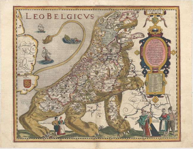
Auction 153, Lot 58
Subject: Cartographic Miscellany, Low Countries
Keere, Pieter Van Den
Leo Belgicus, 1622
Size: 17.9 x 14.6 inches (45.5 x 37.1 cm)
Estimate: $15,000 - $18,000
The Most Popular of the "Lions of Belgium"
Sold for: $11,500
Closed on 5/20/2015
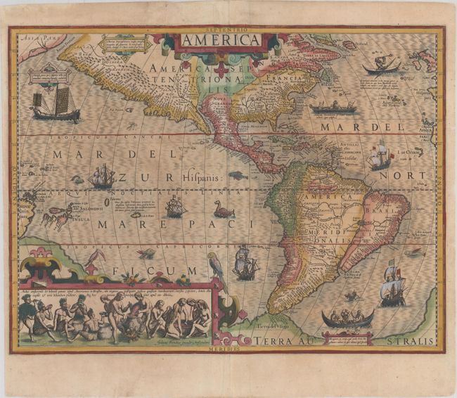
Auction 153, Lot 62
Subject: Western Hemisphere - America
Hondius, Jodocus
America, 1609
Size: 19.7 x 14.8 inches (50 x 37.6 cm)
Estimate: $4,000 - $4,750
Hondius' Important Map of the Americas
Unsold
Closed on 5/20/2015
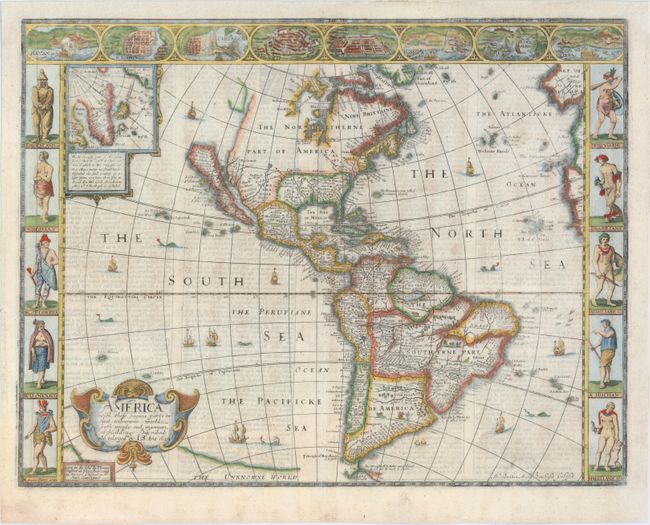
Auction 153, Lot 63
Subject: Western Hemisphere - America
Speed, John
America with Those Known Parts in That Unknowne Worlde Both People and Manner of Buildings Discribed and Inlarged, 1626
Size: 20.3 x 15.6 inches (51.6 x 39.6 cm)
Estimate: $6,000 - $7,500
Speed's Popular Carte-a-Figures Map of the Americas
Unsold
Closed on 5/20/2015
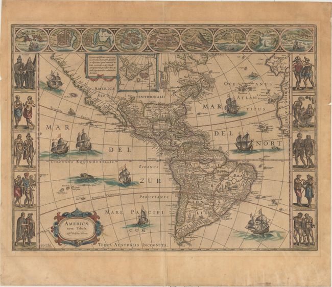
Auction 153, Lot 64
Subject: Western Hemisphere - America
Hondius/Jansson
America Noviter Delineata, 1632
Size: 22 x 16.3 inches (55.9 x 41.4 cm)
Estimate: $8,000 - $10,000
Jansson's Rare Carte-a-Figures Map of the Americas
Unsold
Closed on 5/20/2015
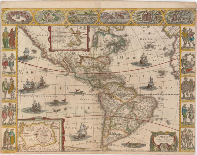
Auction 153, Lot 65
Subject: Western Hemisphere - America
Blaeu, Willem
Americae Nova Tabula, 1640
Size: 22 x 16.3 inches (55.9 x 41.4 cm)
Estimate: $4,750 - $6,000
Blaeu's Stunning Carte-a-Figures Map of the Americas
Unsold
Closed on 5/20/2015
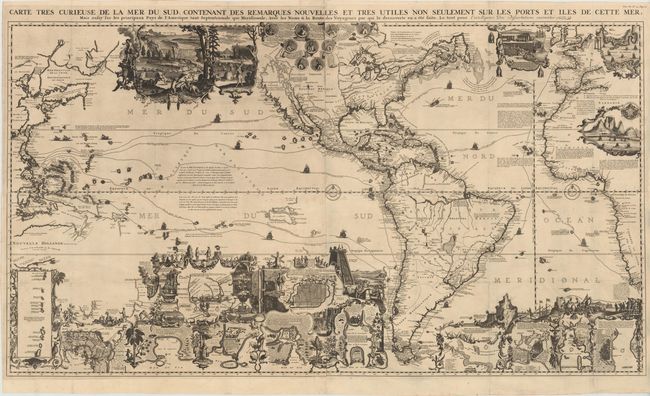
Auction 153, Lot 70
Subject: Western Hemisphere - America
Chatelain, Henry Abraham
Carte Tres Curieuse de la Mer du Sud, Contenant des Remarques Nouvelles et Tres Utiles Non Seulement sur les Ports et Iles de Cette Mer..., 1719
Size: 56 x 31.2 inches (142.2 x 79.2 cm)
Estimate: $15,000 - $18,000
Spectacular Wall Map Celebrating the New World
Sold for: $11,000
Closed on 5/20/2015
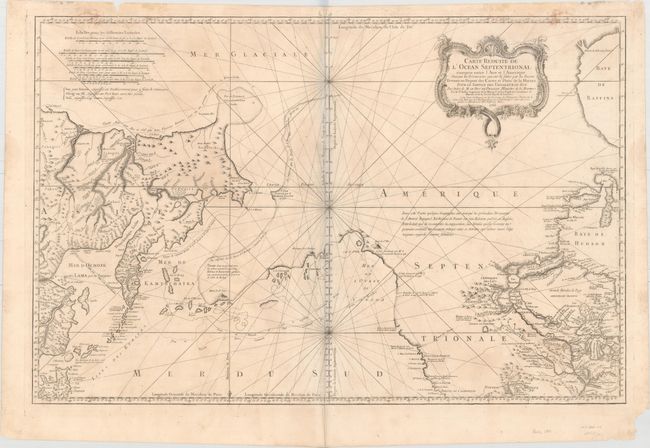
Auction 153, Lot 96
Subject: Western North America & North Pacific Ocean
Bellin, Jacques Nicolas
Carte Reduite de l'Ocean Septentrional Compris Entre l'Asie et l'Amerique, Suivant les Decouvertes qui ont ete Faites par les Russes..., 1766
Size: 33.5 x 22 inches (85.1 x 55.9 cm)
Estimate: $1,200 - $1,500
A Fascinating Map Showing Bering's Discoveries and the River and Lake Systems in North America
Sold for: $500
Closed on 5/20/2015
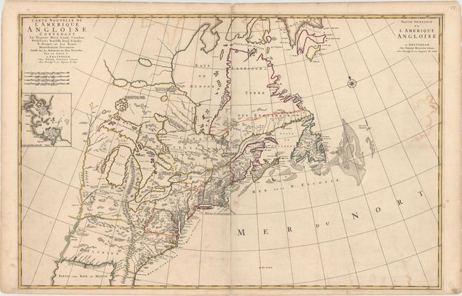
Auction 153, Lot 118
Subject: Colonial Eastern United States & Canada
Mortier, Pierre
Carte Nouvelle de l'Amerique Angloise Contenant la Virginie, Mary-Land, Caroline, Pensylvania Nouvelle Iorck, N: Iarsey N: France, et les Terres Nouvellement Decouerte..., 1700
Size: 35.8 x 23.4 inches (90.9 x 59.4 cm)
Estimate: $2,400 - $3,000
A Map Showing Fascinating Geographic Misconceptions
Unsold
Closed on 5/20/2015
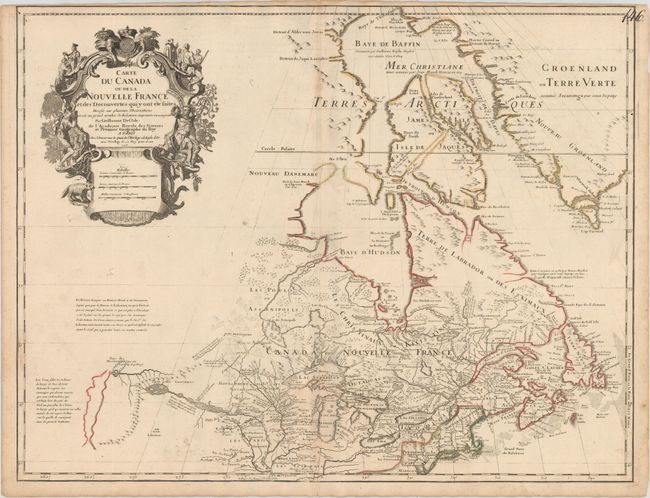
Auction 153, Lot 122
Subject: Colonial Northeastern United States & Canada, Great Lakes
Delisle, Guillaume
Carte du Canada ou de la Nouvelle France et des Decouvertes qui y ont ete Faites..., 1703
Size: 25.5 x 19.6 inches (64.8 x 49.8 cm)
Estimate: $2,200 - $2,500
Delisle's Seminal Map of Canada and the Great Lakes
Sold for: $1,400
Closed on 5/20/2015
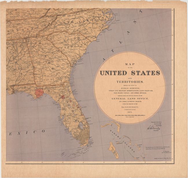
Auction 153, Lot 139
Subject: United States
General Land Office
[On 6 Sheets] Map of the United States and Territories, Showing the Extent of Public Surveys..., 1875
Size: 24 x 25.3 inches (61 x 64.3 cm)
Estimate: $1,800 - $2,200
Burdett's Rare Six-Sheet Map of the United States
Sold for: $1,300
Closed on 5/20/2015
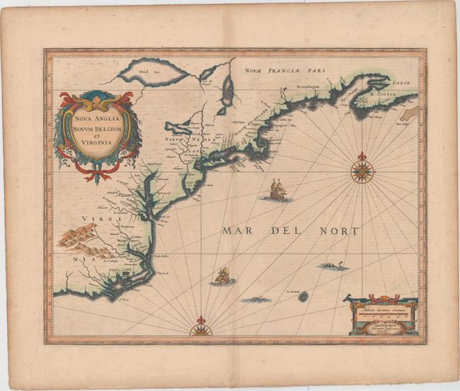
Auction 153, Lot 154
Subject: Colonial New England & Mid-Atlantic United States
Jansson, Jan
Nova Anglia Novum Belgium et Virginia, 1639
Size: 19.8 x 15.3 inches (50.3 x 38.9 cm)
Estimate: $1,800 - $2,100
Jansson's Influential Map of the East Coast
Sold for: $1,200
Closed on 5/20/2015
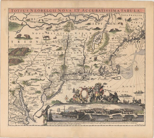
Auction 153, Lot 156
Subject: Colonial New England & Mid-Atlantic
Allard, Carel
Totius Neobelgii Nova et Accuratissima Tabula, 1680
Size: 21.3 x 18.3 inches (54.1 x 46.5 cm)
Estimate: $10,000 - $12,000
Rare Map of New England with Famous "Restitutio" View of New York City
Unsold
Closed on 5/20/2015
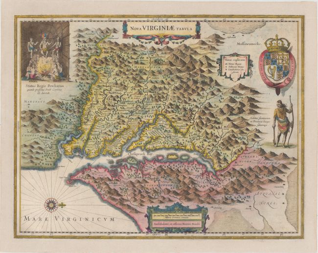
Auction 153, Lot 165
Subject: Colonial Mid-Atlantic United States
Hondius, Henricus
Nova Virginiae Tabula, 1630
Size: 19.5 x 15.2 inches (49.5 x 38.6 cm)
Estimate: $2,000 - $2,300
One of the Most Important 17th Century Maps of the Chesapeake Bay
Sold for: $1,400
Closed on 5/20/2015
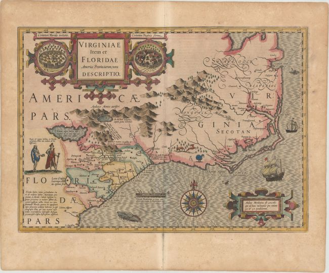
Auction 153, Lot 178
Subject: Colonial Southeast United States
Hondius, Jodocus
Virginiae Item et Floridae Americae Provinciarum, Nova Descriptio, 1623
Size: 19.2 x 13.6 inches (48.8 x 34.5 cm)
Estimate: $2,200 - $3,000
A Seminal Map of the Southeast and Early American Cartography
Unsold
Closed on 5/20/2015
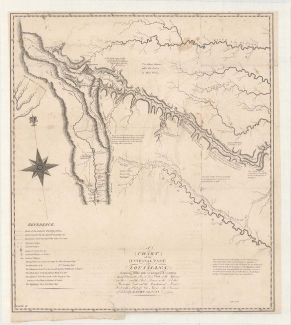
Auction 153, Lot 214
Subject: Southwestern United States
Pike, Zebulon
A Chart of the Internal Part of Louisiana, Including All the Hitherto Unexplored Countries..., 1810
Size: 15.4 x 17.4 inches (39.1 x 44.2 cm)
Estimate: $3,500 - $4,250
A Cornerstone Map of Early Western Exploration
Sold for: $2,500
Closed on 5/20/2015
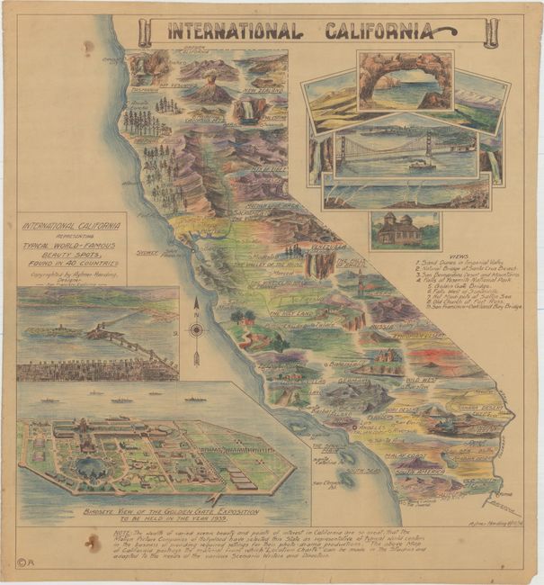
Auction 153, Lot 232
Subject: California
International California, 1936
Size: 20.7 x 22.7 inches (52.6 x 57.7 cm)
Estimate: $300 - $400
A Map Designed for Hollywood Movie Studios
Sold for: $750
Closed on 5/20/2015
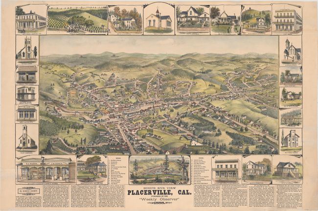
Auction 153, Lot 245
Subject: Placerville, California
Elliott, Wallace W.
Bird's Eye View Placerville, Cal., 1888
Size: 29 x 21 inches (73.7 x 53.3 cm)
Estimate: $2,400 - $3,000
View of California Gold Rush Town
Sold for: $1,500
Closed on 5/20/2015
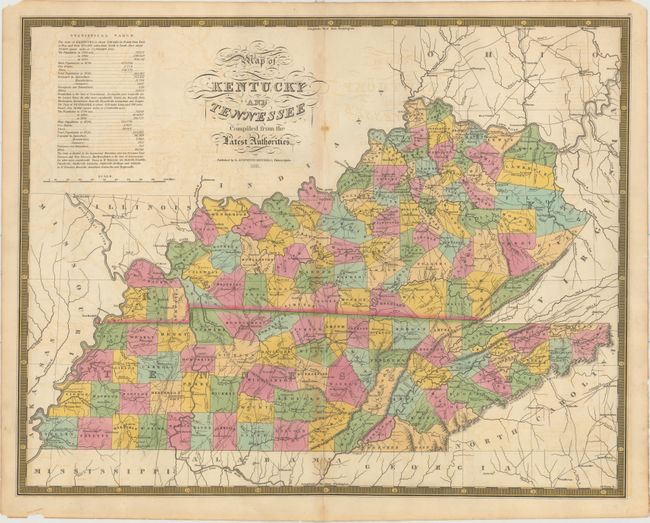
Auction 153, Lot 269
Subject: Kentucky & Tennessee
Mitchell, Samuel Augustus
Map of Kentucky and Tennessee Compiled from the Latest Authorities, 1831
Size: 21.5 x 17 inches (54.6 x 43.2 cm)
Estimate: $1,400 - $1,700
Rare Map Based on Finley's Map of 1826
Unsold
Closed on 5/20/2015
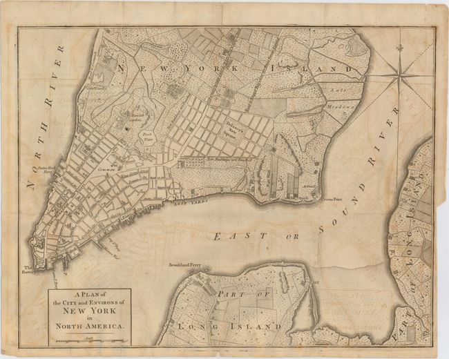
Auction 153, Lot 298
Subject: New York City, New York, Revolutionary War
Anon.
A Plan of the City and Environs of New York in North America, 1776
Size: 14.5 x 11.3 inches (36.8 x 28.7 cm)
Estimate: $1,400 - $1,700
Revolutionary War Era Plan of New York City
Sold for: $2,500
Closed on 5/20/2015
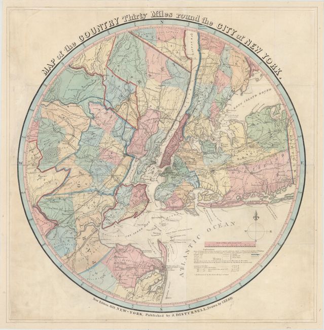
Auction 153, Lot 299
Subject: New York City, New York
Eddy, John H.
Map of the Country Thirty Miles Round the City of New York, 1839
Size: 22.5 x 22.7 inches (57.2 x 57.7 cm)
Estimate: $2,000 - $2,400
Rare Circular Map of New York by Eddy
Sold for: $1,500
Closed on 5/20/2015
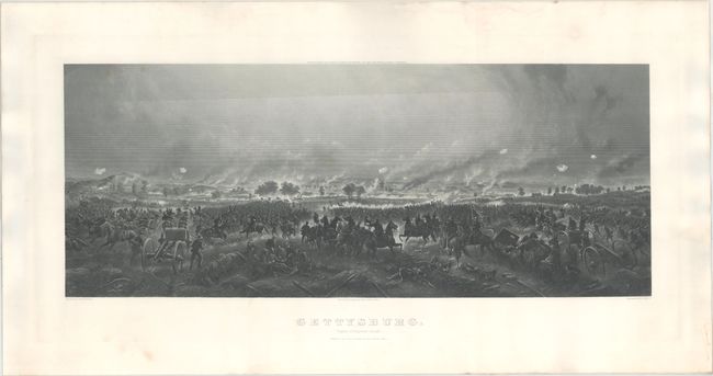
Auction 153, Lot 308
Subject: Gettysburg, Pennsylvania, Civil War
Bachelder, John B.
Gettysburg. Repulse of Longstreet's Assault, 1876
Size: 35.5 x 14.3 inches (90.2 x 36.3 cm)
Estimate: $2,500 - $3,250
Stunning View of Pickett's Charge
Sold for: $1,500
Closed on 5/20/2015
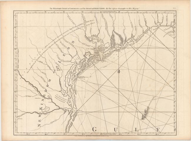
Auction 153, Lot 314
Subject: Texas
Jefferys/Sayer
The Western Coast of Louisiana and the Coast of New Leon, 1792
Size: 24.6 x 18.8 inches (62.5 x 47.8 cm)
Estimate: $2,750 - $3,500
Important Map for Texas Collectors
Sold for: $2,200
Closed on 5/20/2015
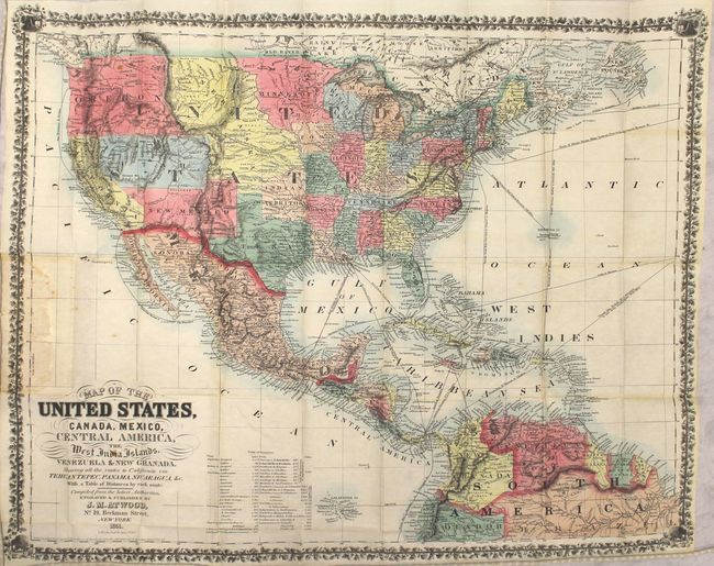
Auction 153, Lot 337
Subject: United States & Mexico, Central America
Atwood, J. M.
Map of the United States, Canada, Mexico, Central America, the West India Islands, Venezuela & New Granada. Showing All the Routes to California via Tehuantepec, Panama, Nicaragua, &c., 1851
Size: 25.5 x 20.5 inches (64.8 x 52.1 cm)
Estimate: $2,400 - $3,000
Rare Pocket Map of the Gold Regions of California
Sold for: $1,500
Closed on 5/20/2015
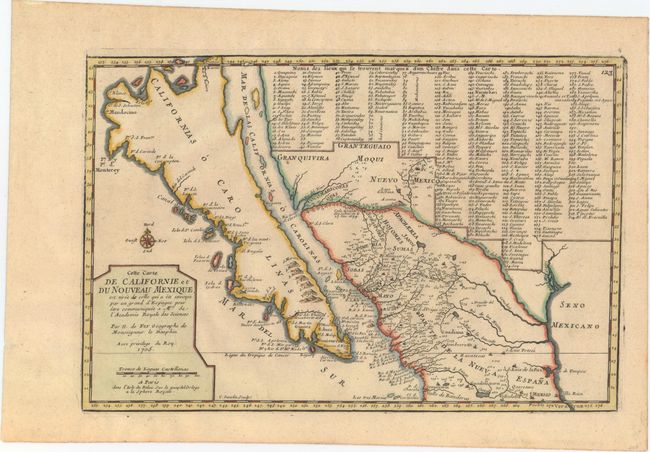
Auction 153, Lot 343
Subject: Southwestern United States & Mexico, California
Fer, Nicolas de
Cette Carte de Californie et du Nouveau Mexique, est Tiree de Celle qui a ete Envoyee par un Grand d'Espagne..., 1705
Size: 13.4 x 8.9 inches (34 x 22.6 cm)
Estimate: $1,300 - $1,600
De Fer's Important Map of the Island of California
Unsold
Closed on 5/20/2015
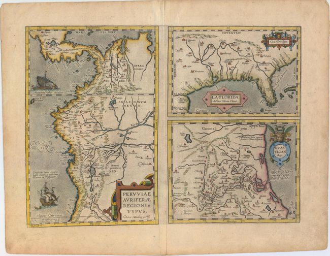
Auction 153, Lot 370
Subject: Gulf of Mexico, Florida & Peru
Ortelius, Abraham
Peruviae Auriferae Regionis Typus. Didaco Mendezio Auctore [on sheet with] La Florida. Auctore Hieron. Chiaves [and] Guastecan Reg., 1602
Size: 18.3 x 13.2 inches (46.5 x 33.5 cm)
Estimate: $1,600 - $1,900
The First Printed Map of the Southern United States
Unsold
Closed on 5/20/2015
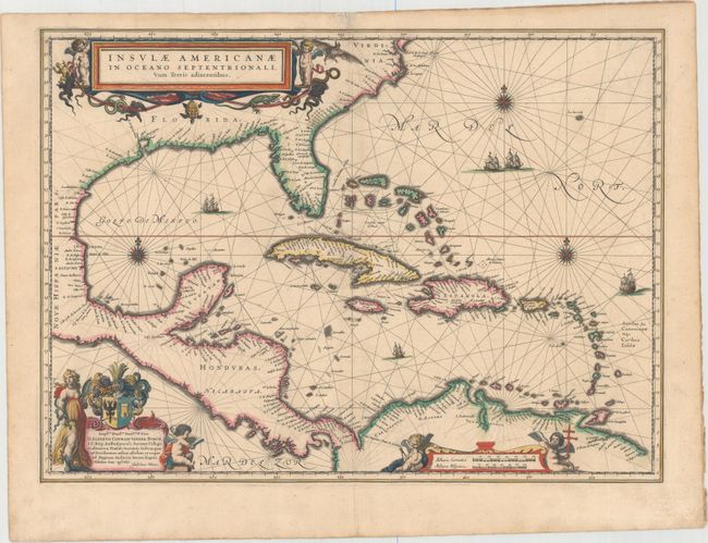
Auction 153, Lot 371
Subject: Gulf of Mexico & Caribbean
Blaeu, Willem
Insulae Americanae in Oceano Septentrionali, cum Terris Adiacentibus, 1638
Size: 20.7 x 15.1 inches (52.6 x 38.4 cm)
Estimate: $1,600 - $1,900
Map of the West Indies Based on Voyage of Hessel Gerritsz
Sold for: $1,000
Closed on 5/20/2015
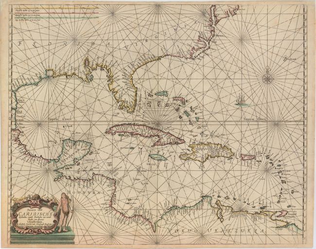
Auction 153, Lot 372
Subject: Gulf of Mexico & Caribbean
Doncker, Henrick
Pascaerte vande Caribische Eylanden, vande Barbados tot Aende Bocht van Mexico, 1659
Size: 21.5 x 17.2 inches (54.6 x 43.7 cm)
Estimate: $6,000 - $7,500
Rare Sea Chart with Interesting Depiction of the Coastline of the US
Sold for: $3,000
Closed on 5/20/2015
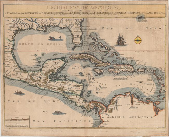
Auction 153, Lot 374
Subject: Gulf of Mexico & Caribbean
Fer, Nicolas de
Le Golfe de Mexique, et les Provinces et Isles qui l'Environe Comme sont la Floride au Nord, le Mexique ou Nouvelle Espagne..., 1717
Size: 23.8 x 18.2 inches (60.5 x 46.2 cm)
Estimate: $1,600 - $1,900
De Fer's Scarce Map of the Gulf of Mexico with Florida as a Peninsula
Unsold
Closed on 5/20/2015
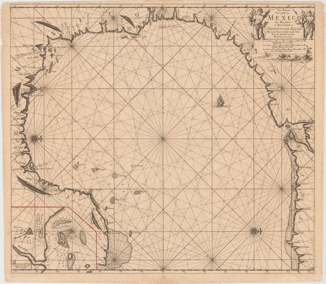
Auction 153, Lot 379
Subject: Gulf of Mexico
Keulen, Johannes van
Pas Kaart van de Golff van Mexico, 1695
Size: 23.1 x 20.4 inches (58.7 x 51.8 cm)
Estimate: $3,000 - $3,750
The First Sea Chart of the Western Portion of the Gulf of Mexico
Unsold
Closed on 5/20/2015
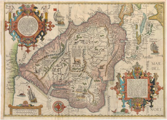
Auction 153, Lot 396
Subject: South America & Caribbean
Linschoten/Langren
Delineatio Omnium Orarum Totius Australis Partis Americae, Dictae Peruvianae, a R. de la Plata, Brasiliam, Pariam, & Castellam Auream..., 1596
Size: 21.4 x 15.2 inches (54.4 x 38.6 cm)
Estimate: $5,500 - $7,000
One of the Most Decorative Early Maps of South America
Sold for: $4,000
Closed on 5/20/2015
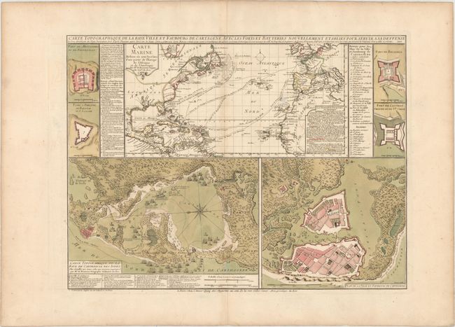
Auction 153, Lot 408
Subject: Cartagena, Colombia
Beaurain, Jean Chev. De
Carte Topographique de la Baye Ville et Faubourg de Cartagene avec les Forts et Batteries Nouvellement Etablies pour Servir a sa Defense..., 1741
Size: 23.3 x 17.3 inches (59.2 x 43.9 cm)
Estimate: $1,100 - $1,400
Rare Map Illustrating the Battle of Cartagena
Sold for: $2,000
Closed on 5/20/2015
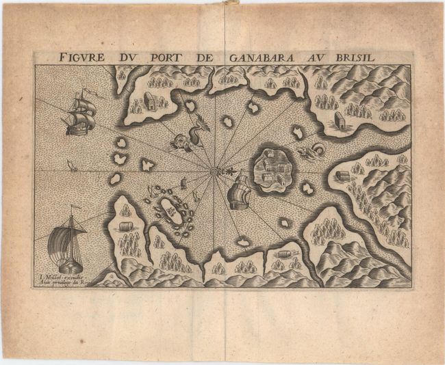
Auction 153, Lot 416
Subject: Guanabara Bay, Brazil
Lescarbot, Marc
Figure du Port de Ganabara au Brisil, 1609
Size: 6.7 x 4 inches (17 x 10.2 cm)
Estimate: $1,000 - $1,300
Rare Map of Guanabara Bay in Lescarbot's History of French Settlements in America
Sold for: $750
Closed on 5/20/2015
78 lots
Page 1 of 2