Subject: Western North America & North Pacific Ocean
Period: 1766 (dated)
Publication: Hydrographie Francoise
Color: Black & White
Size:
33.5 x 22 inches
85.1 x 55.9 cm
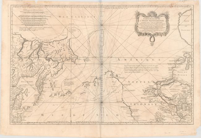
This captivating large-scale chart depicts the North Pacific Ocean from Japan and Russia to North America. Although the focus of the map is the discoveries of Captains Bering and Chirikof around Alaska and the Pacific Northwest, the map includes extensive information in North America, extending to Baffin Bay, Hudson Bay, and Lake Erie in the east and to Point Conception, California, and Fort Assumption along the Mississippi River (in present-day Tennessee) in the south. There are numerous notes of discoveries throughout the map, including a notation west of the Hudson Bay explaining that despite English reports of Admiral de Fuente's explorations, his discoveries could not pass "critical examination" and that the author had always regarded them as "fantastical."
The cartography of the lake and river systems in North America is fascinating. Bellin omits the Sea of the West that appeared on his 1755 map of Canada and the US, but includes a dotted line denoting the River of the West connecting to several rivers and lakes before reaching Hudson Bay. Just to the south is another dotted-line river extending east, but trailing off before connecting with the Missouri River. The Mississippi River connects to Lac Rouge and also reaches Hudson Bay through several rivers and lakes, creating a water route to the Gulf of Mexico.
The tracks and discoveries of Captains Bering and Chirikof are depicted, with Alaska shown in a similar "turtle shape" as seen on earlier maps by German professor Gerhard Friedrich Muller. The Gulf of Alaska is here named Mer de l'Ouest du Canada, one of the few maps to use this term. In Asia, Siberia is fairly well defined based on charts by Russian navigators, while Japan is presented in a rudimentary shape with Hokkaido entirely missing.
This is the first state. A rare and fascinating addition to any collection of the Pacific Northwest.
References: Kershaw #1125; Wagner #610; Tooley (MCC-96) #771; Falk #1766-1; McGuirk #133.
Condition: B
On watermarked paper with a few stains along the neatline at top, light soiling, faint offsetting, and remnants of hinge tape on verso. There are some chips and edge tears in the blank margins, with one tear entering the border at top left, and a pair of worm holes around the centerfold in the top blank margin. The bluish shadow along the centerfold in the image is due to the scanning process and is not present on the actual map.