Subject: Cartagena, Colombia
Period: 1741 (dated)
Publication:
Color: Hand Color
Size:
23.3 x 17.3 inches
59.2 x 43.9 cm
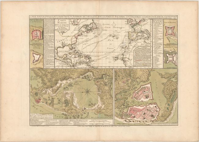
This fascinating sheet contains several maps and bird's-eye plans to illustrate the British siege of Cartagena in 1741. In March 1741, Spanish and native forces successfully defended the city against attack from a much larger fleet of British and American colonial troops. The British and American troops were led by Admiral Edward Vernon, who commanded a fleet of 186 ships and 23,600 men to capture the Spanish port. The British suffered massive casualties, in part due to the spread of disease on the ships. The Battle of Cartagena was the most significant battle of the War of Jenkins' Ear. The large map at the center of this sheet depicts the north Atlantic Ocean with the routes of British, French and Spanish ships shown, and also identifies the possessions of the various European powers in the New World. Below are a topographic map of the area surrounding Cartagena, and a bird's-eye plan of Cartagena showing its heavy fortifications. The sheet also includes four small bird's-eye plans of important forts in the area, as well as numbered keys identifying important locations.
References: Kapp (MCC-77) #76.
Condition: A
A nice impression and attractive color on watermarked paper with wide margins. There is one small abrasion near the Canary Islands and a hint of toning along the centerfold and edges of the sheet.