Subject: Southwestern United States
Period: 1810 (circa)
Publication: An Account of Expeditions to the Sources of the Mississippi…
Color: Black & White
Size:
15.4 x 17.4 inches
39.1 x 44.2 cm
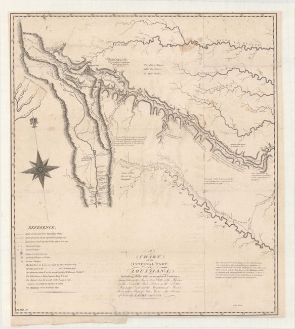
This map was included in Pike’s landmark report of the Southwest, describing his expeditions from 1805-1807. His book is one of the most important of all American travel narratives, and stands alongside those of Lewis and Clark as a cornerstone of early western exploration. The report itself (not included) contains accounts of Pike's travels to find the headwaters of the Arkansas and Red Rivers, his explorations along the Mississippi River, and his Spanish escort to Santa Fe, New Mexico and Chihuahua, Mexico.
Contained within the report are six maps including this very notable one focused on the region from the Red River west to the Rio Grande and north to above Highest Peak (later to be named Pike’s Peak). It depicts the path of the American Exploring Expedition to the Rocky Mountains as well as the route of the pursuing Spaniards. A legend at bottom left identifies American camps, Spanish camps, villages and survey work. The map is filled with interesting notations including "Source of the Red River of the Mississippi," "Innumerable Herds of Buffaloes &c..." and "Stockdale met by the Spaniards."
Wheat notes that this map, along with the eastern sheet (Wheat #297), were "the first maps of this entire region to display knowledge derived from actual explorations" and were "milestones in the mapping of the American West." A cornerstone map for collectors of western Americana.
References: Wheat (TMW) #298; Blevins #6; Cohen pp. 97-99.
Condition: B
Backed with tissue to reinforce and repair several tiny splits at fold intersections and an edge tear at bottom that extends 2" into a blank area of the map. Faint offsetting, minor soiling, and trimmed close to the neatline at left, top and bottom right.