Subject: World
Period: 1630 (circa)
Publication:
Color: Hand Color
Size:
21.3 x 16.1 inches
54.1 x 40.9 cm
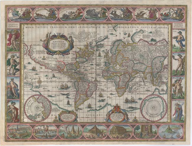
A magnificent map featuring a carte-a-figures border with allegorical representations of the sun, the moon, the five known planets, the four elements and the four seasons. Along the bottom are vignettes showing the seven wonders of the world: the Hanging Gardens of Babylon; the Colossus straddling the harbor at Rhodes; the Pyramids; the Mausoleum of Halicarnassus in Bodrum, Turkey; the Temple of Diana; the Statue of Jupiter; and the lighthouse at Alexandria. Josua van Ende engraved this map, reducing it from Blaeu's 1605 wall map for inclusion in atlases.
Petrus Plancius' world map of 1592 was the main source of geographical information. The map is shown on Mercator's projection with a massive Southern Continent attached to New Guinea, with the coastal names of Beach and Psittacorum regio noted from Marco Polo's travel memoirs. North America has the westward bulge characteristic of the time, with the Strait of Anian noted. Korea is shown as an island and Japan is in a kite-like shape. The map itself is richly decorated with cartouches, sea battles, monsters and compass roses. Fourth state with Tierra del Fuego shown as an island and the date omitted from the lower cartouche on the right. This example has no text on verso, which is extremely rare. Blaeu's carte-a-figures maps of the world and continents were issued separately, and then first used in an atlas in Blaeu's Atlantis Appendix in 1630. Blaeu's atlases published after 1635 had text on the verso, which are more commonly found on the market. Because this example appears to have been issued folding, it was likely either issued separately or bound into a composite atlas.
References: Goss (Blaeu) #1; Shirley #255; Van der Krogt (Vol. II) #00001:2A.
Condition: B
A nice impression with attractive color. Issued folding and backed in Japanese tissue with expert repairs to some fold separations, several small worm holes, and a few tears, most of which are around 1" in length, with one entering 4" into image near China. The margins have been extended a bit to accommodate framing. Two large chips in the top left and bottom right vignettes have been expertly repaired with the image skillfully replaced in facsimile. Despite the condition issues, this map has been expertly conserved and presents well.