Subject: Texas
Period: 1792 (dated)
Publication: The West-India Atlas
Color: Black & White
Size:
24.6 x 18.8 inches
62.5 x 47.8 cm
Thomas Jefferys was one of the most important English map publishers of the 18th century. His work included prints and maps of locations around the world, but his most notable maps are of North America and the West Indies. He began his career in the map trade in the early 1730s, working as an engraver for a variety of London publishers, and eventually setting up his own shop. In 1746, he was appointed Geographer to the Prince of Wales, and in 1760 he became Geographer to the King. These titles granted access to manuscripts and cartographic information held by the government. In the early 1760s he embarked on an ambitious project to produce a series of English county maps based on new surveys, but ran out of money and filed for bankruptcy in 1766. He then partnered with London publisher Robert Sayer, who reissued many of Jefferys plates and continued to issue new editions after Jefferys' death in 1771. Jefferys' American Atlas and the accompanying West-India Atlas, published post posthumously, are considered his most important cartographic works.
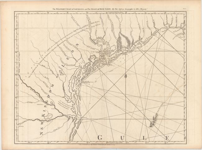
This map depicts the coast of Texas from the Rio Grande to the Sabine River, and was published as one sheet of a sixteen-sheet chart of the whole of the West Indies. First published in 1775, this map was the "principal authority for the Texas coastline" until the beginning of the 19th century, according to Streeter. Jefferys' map is remarkable for being the first map to focus on the Texas coastline, as well as for its overwhelming geographical inaccuracies. The map depicts the rivers, bays, inlets, and marshland along the coast, with soundings indicated in the coastal waters. In the bottom right corner is a fleet of ships with the notation "Ancient Track of the Flotta." Notes are also included in the interior, with particular emphasis on the location of Indian villages. La Salle's settlement from 1685 is also shown.
The inaccuracy of the chart is likely due in part to the secrecy of the Spanish in their charts and documents, despite the fact that Jefferys is known to have used sketches and maps that were captured by the British from Spanish warships. The use of English, Spanish and French nomenclature in the map demonstrates the diversity in sources used by Jefferys, and it is possible that the combination of the various sources led to the jumbled depiction of the coastline. As a result of the flawed geography of the map, it remains an important historical document demonstrating the lack of knowledge of Texas at the end of the 18th century.
References: Martin & Martin #21; Streeter #1029 (notes); Shirley (BL Atlases) M.JEF-4a #8.
Condition: B+
A nice impression on sturdy, watermarked paper with light offsetting, a soft extraneous crease adjacent to centerfold, and toning along edges of sheet.