Showing Featured Lots(remove filter)
Filtered by Category:United States(Show All Categories)
Showing results for:Auction 181
Catalog Archive
29 lots
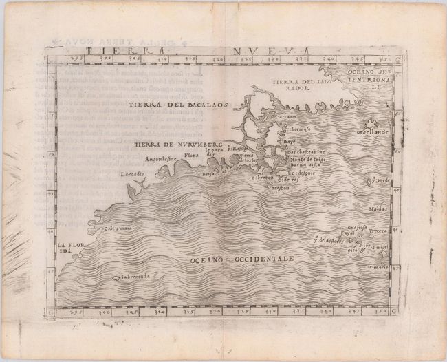
Auction 181, Lot 102
Subject: Eastern United States & Canada
Gastaldi, Giacomo
Tierra Nueva, 1548
Size: 6.7 x 4.9 inches (17 x 12.4 cm)
Estimate: $2,750 - $3,500
The First Published Map Devoted to the East Coast of North America
Sold for: $3,250
Closed on 2/10/2021
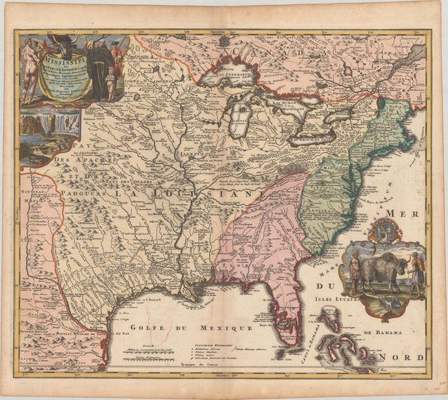
Auction 181, Lot 104
Subject: Colonial Eastern United States & Canada
Homann, Johann Baptist
Amplissimae Regionis Mississipi seu Provinciae Ludovicianae a R.P. Ludovico Hennepin Francisc Miss in America Septentrionali Anno 1687..., 1720
Size: 22.9 x 19.1 inches (58.2 x 48.5 cm)
Estimate: $2,400 - $3,000
Striking Map of Colonial America with Bison Vignette
Sold for: $1,700
Closed on 2/10/2021
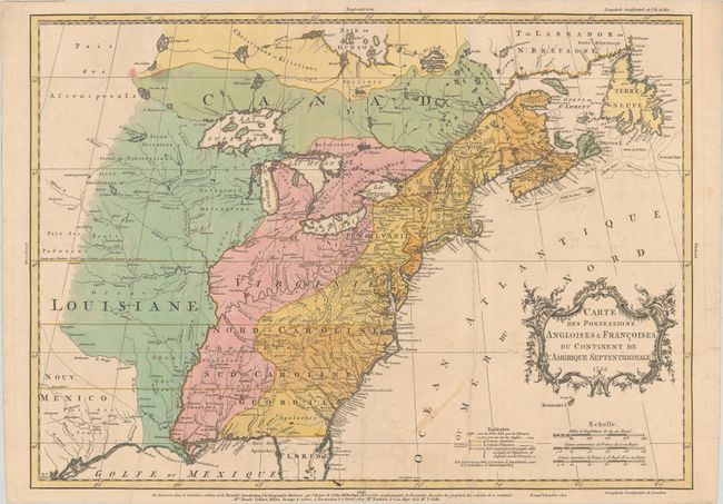
Auction 181, Lot 105
Subject: Colonial Eastern United States & Canada
Palairet, Jean
Carte des Possessions Angloises & Francoises du Continent de l'Amerique Septentrionale, 1755
Size: 22.7 x 16.3 inches (57.7 x 41.4 cm)
Estimate: $2,200 - $2,500
Important Map of French and English Territorial Claims at the Outset of the French & Indian War
Sold for: $2,000
Closed on 2/10/2021
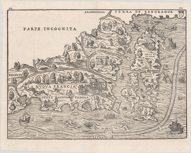
Auction 181, Lot 113
Subject: Colonial Northeastern United States & Canada
Gastaldi/Ramusio
La Nuova Francia, 1606
Size: 14.6 x 10.6 inches (37.1 x 26.9 cm)
Estimate: $3,500 - $4,250
The First Printed Map to Focus on New England and New France
Sold for: $2,750
Closed on 2/10/2021
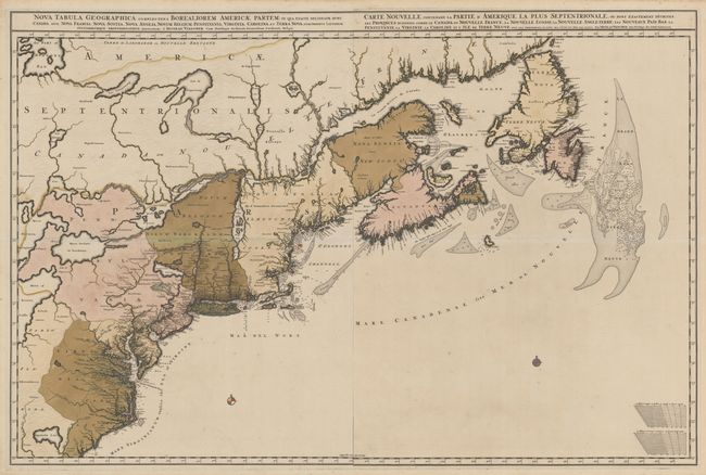
Auction 181, Lot 114
Subject: Colonial Northeastern United States & Canada
Visscher, Nicolas
[Lot of 2] Nova Tabula Geographica Complectens Borealiorem Americae Partem... [and] Carte Nouvelle Contenant la Partie d'Amerique la Plus Septentrionale, ou sont Exactement Decrites les Provinces..., 1696
Size: 18.6 x 23.3 inches (47.2 x 59.2 cm)
Estimate: $4,000 - $5,000
Very Rare First State in Full Contemporary Color
Sold for: $2,750
Closed on 2/10/2021
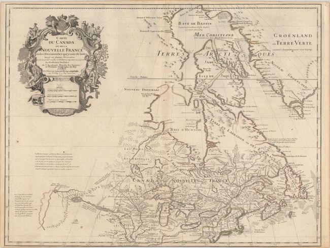
Auction 181, Lot 115
Subject: Colonial Northeastern United States & Canada, Great Lakes
Delisle, Guillaume
Carte du Canada ou de la Nouvelle France et des Decouvertes qui y ont ete Faites Dressee sur Plusieurs Observations et sur un Grand Nombre de Relations Imprimees ou Manuscrites, 1703
Size: 25.6 x 19.6 inches (65 x 49.8 cm)
Estimate: $1,400 - $1,700
Delisle's Seminal Map of Canada and the Great Lakes
Sold for: $850
Closed on 2/10/2021
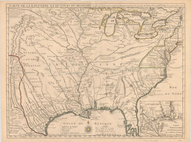
Auction 181, Lot 140
Subject: Colonial Eastern United States
Delisle, Guillaume
Carte de la Louisiane et du Cours du Mississipi Dressee sur un Grand Nombre de Memoires Entrautres sur ceux de Mr. le Maire, 1718
Size: 25.3 x 19.1 inches (64.3 x 48.5 cm)
Estimate: $6,000 - $7,500
A Foundation Map for the Mississippi Valley and the First Appearance of Texas on a Printed Map
Sold for: $6,000
Closed on 2/10/2021
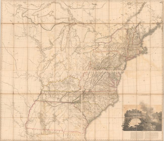
Auction 181, Lot 146
Subject: Eastern United States
Arrowsmith, Aaron, Sr.
[On 4 Sheets] A Map of the United States of North America Drawn from a Number of Critical Researches, 1802
Size: 27.8 x 24.3 inches (70.6 x 61.7 cm)
Estimate: $7,000 - $8,500
Arrowsmith's Large-Format Map Used by Lewis & Clark
Sold for: $4,000
Closed on 2/10/2021
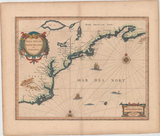
Auction 181, Lot 153
Subject: Colonial New England & Mid-Atlantic United States
Jansson, Jan
Nova Anglia Novum Belgium et Virginia, 1639
Size: 19.8 x 15.3 inches (50.3 x 38.9 cm)
Estimate: $1,400 - $1,700
Jansson's Influential Map of the East Coast
Sold for: $1,000
Closed on 2/10/2021
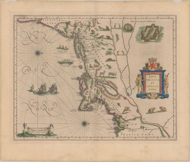
Auction 181, Lot 154
Subject: Colonial New England & Mid-Atlantic United States
Blaeu, (Family)
Nova Belgica et Anglia Nova, 1640
Size: 19.8 x 15.1 inches (50.3 x 38.4 cm)
Estimate: $1,900 - $2,200
Important Map of Colonial New England and the Mid-Atlantic
Sold for: $1,300
Closed on 2/10/2021
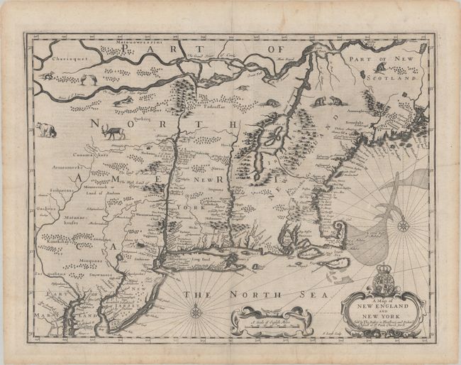
Auction 181, Lot 156
Subject: Colonial New England & Mid-Atlantic United States
Speed/Lamb
A Map of New England and New York, 1676
Size: 19.5 x 14.8 inches (49.5 x 37.6 cm)
Estimate: $3,500 - $4,250
"Speed" Map of New England
Sold for: $2,500
Closed on 2/10/2021
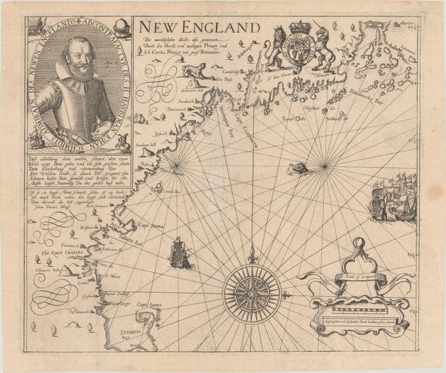
Auction 181, Lot 157
Subject: Colonial New England United States
Smith, John (Capt.)
New England die Mercklichsten Dheile..., 1617
Size: 13.6 x 11.5 inches (34.5 x 29.2 cm)
Estimate: $7,500 - $9,000
German Edition of Capt. John Smith's Foundation Map of New England
Sold for: $6,500
Closed on 2/10/2021
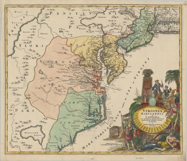
Auction 181, Lot 159
Subject: Colonial Mid-Atlantic United States
Homann, Johann Baptist
Virginia Marylandia et Carolina in America Septentrionali Britannorum Industria Excultae Repraesentatae, 1730
Size: 22.8 x 19.2 inches (57.9 x 48.8 cm)
Estimate: $1,700 - $2,000
Map Created to Promote German Immigration to the New World
Sold for: $1,100
Closed on 2/10/2021
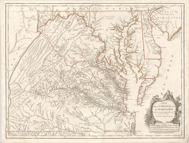
Auction 181, Lot 162
Subject: Mid-Atlantic United States
Robert de Vaugondy, Didier
Carte de la Virginie et du Maryland Dressee sur la Grande Carte Angloise de Mrs. Josue Fry et Pierre Jefferson, 1793
Size: 25.3 x 19 inches (64.3 x 48.3 cm)
Estimate: $1,500 - $1,800
An Essential Map of Virginia and Maryland
Sold for: $1,000
Closed on 2/10/2021
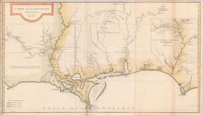
Auction 181, Lot 169
Subject: Colonial Southern United States
Anville, Jean Baptiste Bourguignon d'
Carte de la Louisiane par le Sr. D'Anville Dressee en Mai 1732. Publiee en 1752, 1752
Size: 36.4 x 20.4 inches (92.5 x 51.8 cm)
Estimate: $1,500 - $1,800
An Early, Detailed Depiction of the Gulf Coast
Sold for: $1,400
Closed on 2/10/2021
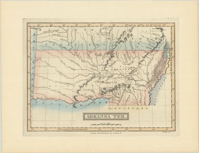
Auction 181, Lot 174
Subject: South Central United States, Arkansas
Lucas, Fielding
Arkansa Ter., 1822
Size: 11.2 x 8.2 inches (28.4 x 20.8 cm)
Estimate: $700 - $900
Rare First State of One of the Most Desirable Maps of Arkansas Territory
Sold for: $500
Closed on 2/10/2021
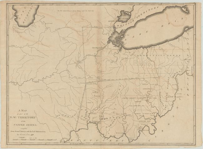
Auction 181, Lot 176
Subject: Central United States
Lewis, Samuel
A Map of Part of the N:W: Territory of the United States: Compiled from Actual Surveys, and the Best Information, 1796
Size: 25.3 x 19.2 inches (64.3 x 48.8 cm)
Estimate: $4,000 - $4,750
Early Map of Northwest Territory Depicting Several Land Grants
Sold for: $3,000
Closed on 2/10/2021
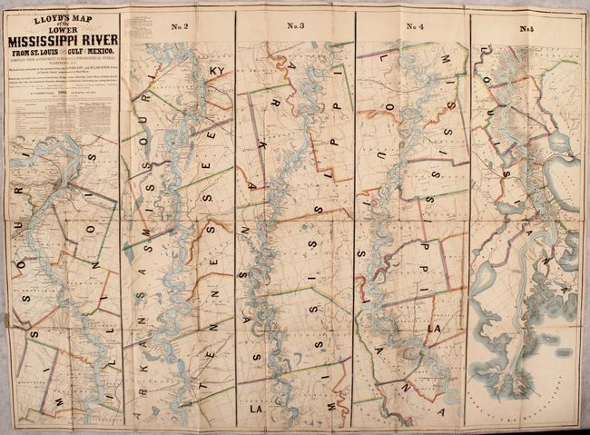
Auction 181, Lot 183
Subject: Mississippi River
Lloyd, James T.
Lloyd's Map of the Lower Mississippi River from St. Louis to the Gulf of Mexico. Compiled from Government Surveys in the Topographical Bureau, Washington, D. C., 1863
Size: 51.3 x 37 inches (130.3 x 94 cm)
Estimate: $8,000 - $9,500
Rare Civil-War Era Strip Map of the Mississippi River
Sold for: $8,000
Closed on 2/10/2021
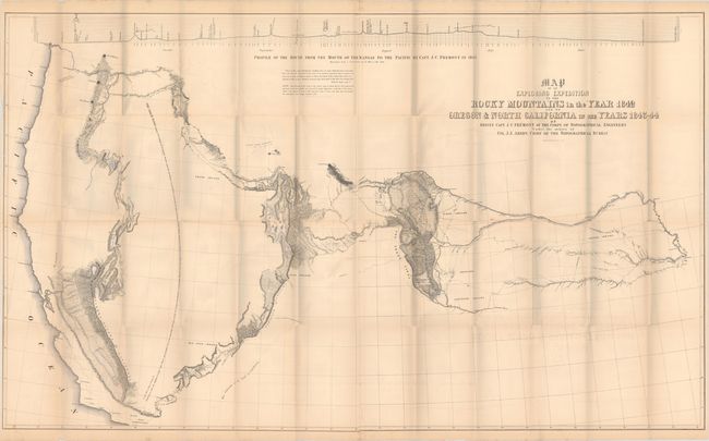
Auction 181, Lot 184
Subject: Western United States
Fremont/Preuss
[Map with Report] Map of an Exploring Expedition to the Rocky Mountains in the Year 1842 and to Oregon & North California in the Years 1843-44 [with] Report of the Exploring Expedition to the Rocky Mountains..., 1845
Size: 51.1 x 30.5 inches (129.8 x 77.5 cm)
Estimate: $1,000 - $1,300
Features Fremont's Large Map of the American West
Sold for: $650
Closed on 2/10/2021
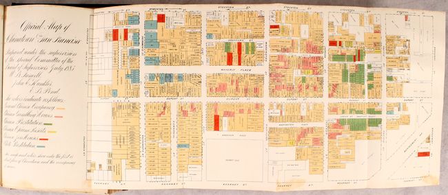
Auction 181, Lot 224
Subject: San Francisco, California
[Map in Book] Official Map of Chinatown in San Francisco [bound in] San Francisco Municpal Reports for the Fiscal Year 1884-85, Ending June 30, 1885, 1885
Size: 20.8 x 8.1 inches (52.8 x 20.6 cm)
Estimate: $750 - $900
Features a Nefarious Chinatown Map
Sold for: $1,100
Closed on 2/10/2021
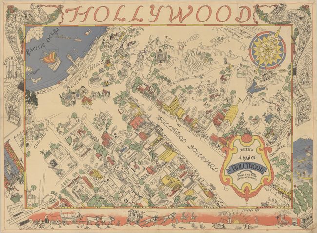
Auction 181, Lot 233
Subject: Hollywood, California
Being a Map of Hollywood from the Best Surveys of the Time, 1926
Size: 33.4 x 24.5 inches (84.8 x 62.2 cm)
Estimate: $2,000 - $2,500
Rare Map from Famed Hollywood Costume Designer and Interior Designer
Sold for: $1,300
Closed on 2/10/2021
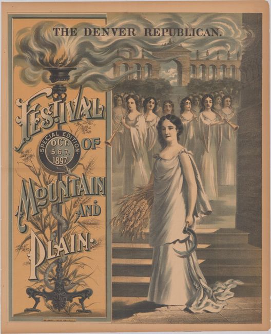
Auction 181, Lot 240
Subject: Denver, Colorado
The Denver Republican. Festival of Mountain and Plain, 1897
Size: 17.8 x 21.7 inches (45.2 x 55.1 cm)
Estimate: $200 - $250
Advertising Poster for Denver’s Version of Mardi Gras
Sold for: $275
Closed on 2/10/2021
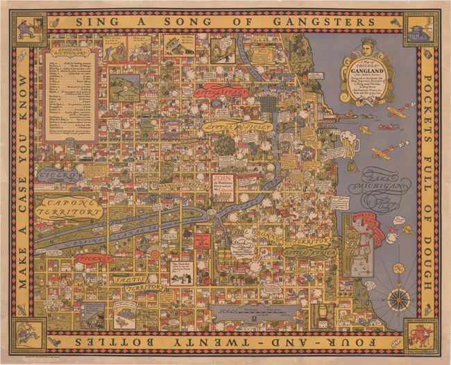
Auction 181, Lot 253
Subject: Chicago, Illinois
A Map of Chicago's Gangland from Authentic Sources Designed to Inculcate the Most Important Principles of Piety and Virtue in Young Persons and Graphically Portray the Evils and Sin of Large Cities, 1931
Size: 27.4 x 22.1 inches (69.6 x 56.1 cm)
Estimate: $14,000 - $18,000
Rare Pictorial Map of Chicago Gang Wars During Prohibition
Sold for: $10,000
Closed on 2/10/2021
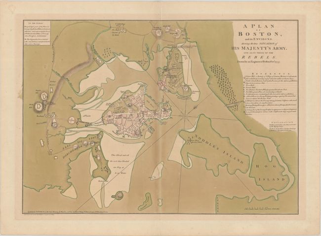
Auction 181, Lot 260
Subject: Boston, Massachusetts
Dury, Andrew
A Plan of Boston, and Its Environs. Shewing the True Situation of His Majesty's Army. And Also Those of the Rebels. Drawn by an Engineer at Boston. Octr. 1775, 1776
Size: 25.4 x 18 inches (64.5 x 45.7 cm)
Estimate: $24,000 - $28,000
Important Revolutionary War Plan from British Perspective in Full Contemporary Color
Sold for: $20,500
Closed on 2/10/2021
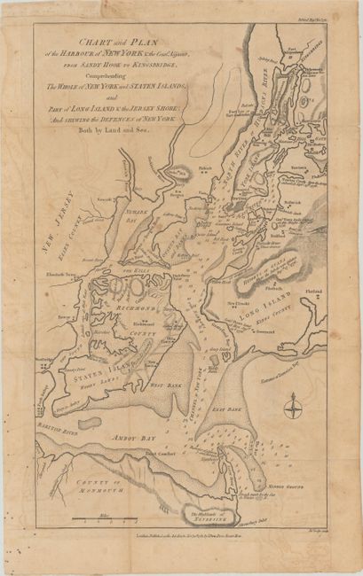
Auction 181, Lot 265
Subject: New York City, New York
Lodge, John
Chart and Plan of the Harbour of New York & the County Adjacent, from Sandy Hook to Kingsbridge, Comprehending the Whole of New York and Staten Islands..., 1781
Size: 9.5 x 16.5 inches (24.1 x 41.9 cm)
Estimate: $1,400 - $1,700
Uncommon Revolutionary War Map of the Vicinity of New York
Sold for: $1,000
Closed on 2/10/2021
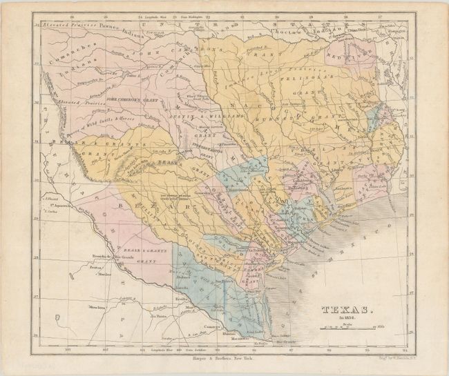
Auction 181, Lot 282
Subject: Texas
Kemble, W.
Texas. In 1836, 1846
Size: 9.3 x 8.3 inches (23.6 x 21.1 cm)
Estimate: $1,200 - $1,500
Republic of Texas with Land Grants
Sold for: $900
Closed on 2/10/2021
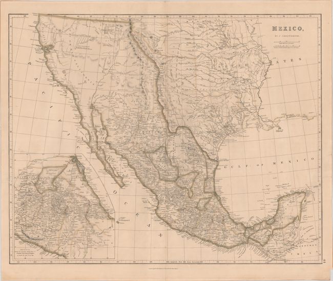
Auction 181, Lot 306
Subject: Southwestern United States & Mexico, Texas
Arrowsmith, John
Mexico, 1842
Size: 23.6 x 18.9 inches (59.9 x 48 cm)
Estimate: $1,600 - $1,900
Features the Republic of Texas in its Largest Configuration
Sold for: $1,400
Closed on 2/10/2021
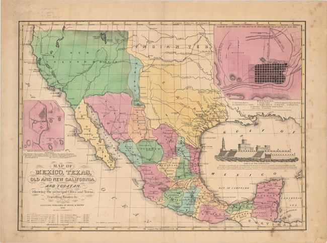
Auction 181, Lot 308
Subject: Southwestern United States & Mexico
Map of Mexico, Texas, Old and New California, and Yucatan. Showing the Principal Cities and Towns, Travelling Routes &c., 1847
Size: 23.6 x 17.3 inches (59.9 x 43.9 cm)
Estimate: $2,750 - $3,500
A Rare Commercial Map Capitalizing on Interest in the American Southwest
Sold for: $1,700
Closed on 2/10/2021
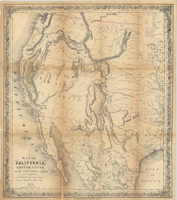
Auction 181, Lot 316
Subject: Western United States & Mexico, Gold
Colton, Joseph Hutchins
Map of California, Oregon, Texas, and the Territories Adjoining with Routes &c., 1849
Size: 18 x 20.6 inches (45.7 x 52.3 cm)
Estimate: $1,400 - $1,700
Colton's Scarce Map Depicting the Gold Region of California
Sold for: $900
Closed on 2/10/2021
29 lots