Catalog Archive
Auction 181, Lot 265

Uncommon Revolutionary War Map of the Vicinity of New York

"Chart and Plan of the Harbour of New York & the County Adjacent, from Sandy Hook to Kingsbridge, Comprehending the Whole of New York and Staten Islands...", Lodge, John

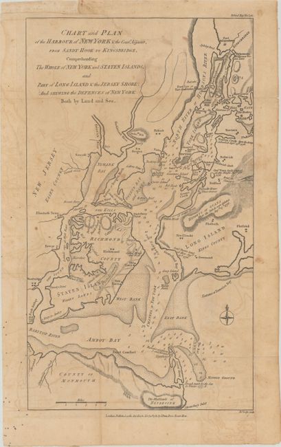
Subject: New York City, New York

Period: 1781 (published)

Publication: Political Magazine

Color: Black & White

Size:
9.5 x 16.5 inches
24.1 x 41.9 cm
Download High Resolution Image
(or just click on image to launch the Zoom viewer)

Uncommon Revolutionary War map showing the defenses for New York and the surrounding area, including Staten and Long islands, Newark and Amboy bays, with notes of dates pertaining to British military activity. The map names Bunker Hill, Crown Point, Fort Independence, and Fort Constitution. In Brooklyn, a road from Yellow Hook (Bay Ridge) is noted as General Grant's route, ending between Thibaults House and Three Graves. Topography is shown by hachures and soundings are noted in the waterways.

References: Jolly #POL-40; Nebenzahl (Biblio) #104.

Condition: B

Issued folding on a watermarked sheet with light toning and offsetting. An edge tear that extends 2.5" into the image at top has been archivally repaired on verso.

Estimate: $1,400 - $1,700

Sold for: $1,000

Closed on 2/10/2021

Archived