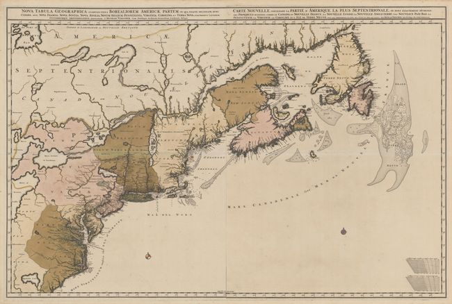
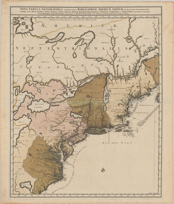
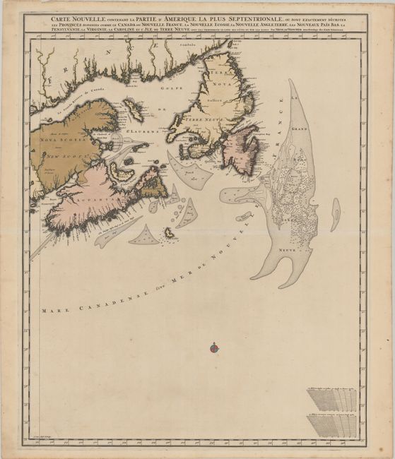
Subject: Colonial Northeastern United States & Canada
Period: 1696 (circa)
Publication: Atlas Minor
Color: Hand Color
Size:
18.6 x 23.3 inches
47.2 x 59.2 cm
This is the first state of this stunning map on two separate sheets covering the Atlantic coast from the Carolinas to Newfoundland, and from the Grand Bank to the Great Lakes. It includes Lake Ontario and parts of Lakes Huron and Erie with a portion of Hudson Bay at the top. The map does not appear to be based on any one source, but draws from the Coronelli/Nolin map of 1689 as well as Dutch and English sources. It displays the divisions between the French and British colonies, including New York, New Jersey, Pennsylvania, Virginia, Maryland and Carolina with meticulously engraved towns. It depicts the colonial settlements along the seaboard and the rivers, while in the interior a number of native nations are shown. The southern portion of the map shows the May River leading from the fictitious Apalache Lac, and the sea off the coast is called The Sea of Virginy. Both sheets have compass roses and soundings noted along the coasts. One map contains the French title and the other the Latin title. They were clearly engraved in such a manner that allowed both unification as a two-sheet map and as individual maps, as can be seen by the guide lines inside each map. Size given is for each sheet. Engraved by Luggert van Anse. This is the very rare first state that lacks engraved mountains and trees, which appear on all later editions. Faint outlines of the mountains can be seen, and Burden surmises that this state was possibly a proof.
References: Burden #731; McCorkle #689.8; Kershaw #319.
Condition: B+
A superb, dark, early impression on supple sheets with "H" and "P" watermarks and full contemporary color. There are a few tiny spots of foxing, a small rust spot off the coast of New Hampshire, and light toning along the edges of the sheets. The first image is a composite image - the map is in 2 separate sheets.