Subject: Chicago, Illinois
Period: 1931 (dated)
Publication:
Color: Printed Color
Size:
27.4 x 22.1 inches
69.6 x 56.1 cm
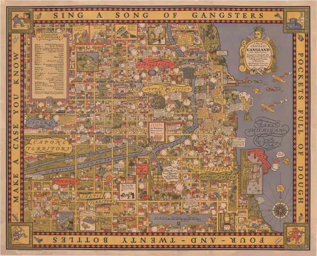
This superb and very rare pictorial map was published by Bruce Roberts, Inc. the same year that Al Capone was convicted on 5 counts of tax evasion. The map takes a humorous, and at times romanticized, look at the decade-long gang wars that plagued Chicago in the 1920's and early 1930's during Prohibition. The city is divided into various gang territories and 12 key gang-related events are numbered chronologically in red circles with scrolls detailing the events. The most prominent of these events is number 11, the 1929 St. Valentine's Day massacre in which Capone's South Side gang executed seven members of the North Side Gang. The skull and crossbones symbol is scattered throughout the map recording other locations were deaths occurred, including Dead Man's Tree on Loomis Street and Death Corner at the intersection of Oak Street and Milton Avenue. The Chicago Sanitary and Ship Canal is noted as "a favorite disposal station" and "Canadian Special" aircraft fly over Lake Michigan to deliver alcohol from the north. The complacency and complicity of the Chicago police is apparent, with officers turning a blind eye to illegal activities. Two insets feature a dictionary of gang terms at top left and an overview of the 1933 World's Fairgrounds at bottom right. Some believe that the rarity of this map is in part due to copies of the map being destroyed in preparation for the World's Fair, as the map portrayed Chicago in a negative light and could potentially discourage tourists.
Every detail of the map has been re-imagined to fit the gang and prohibition themes. The distance scale is measured from "one shooting" to "massacre"; a windhead is blowing on a beer to create froth; and the northern point of the compass rose is a hand shooting a gun, with the "N" appearing in a cloud of gunsmoke. Capone's head, donning a crown and angel's wings, graces the title cartouche. The nursery rhyme "Sing a Song of Sixpence" has also been rewritten and fills the map border: "Sing a song of gangsters, pockets full of dough; Four-and-twenty bottles make a case you know."
Several respected authorities have attributed the map to Arthur Erickson, though, from our research, there appears little, if any, contemporary evidence to support this. The map was made in the Art-Deco style of MacDonald Gill, a British artist who created the Wonderground map of the London Underground.
This map is very rare; we know of only 3 examples that have been offered for sale in the last decade.
References: Hornsby (Picturing America) #56; cf. Rumsey #8984 (reprint).
Condition: B
Issued folding, now flattened and professionally backed in archival tissue to repair some separations along the folds and short tears along the edges of the sheet. There are a number of chips along the edges of the sheet, some entering the map border at bottom, that have been repaired with old paper, with the image skillfully replaced in facsimile. The original imprint below the neatline at bottom right, "Printed in the United States of America," no longer appears in this example.