Subject: Central United States
Period: 1796 (dated)
Publication:
Color: Black & White
Size:
25.3 x 19.2 inches
64.3 x 48.8 cm
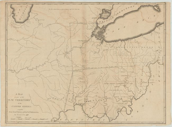
This scarce map covers the region of the Northwest Territory from the southern tip of Lake Michigan, east to include most of Lake Erie, and south to Louisville and the Ohio River. Of particular note are the Revolutionary War Bounty Land Grants shown in the region; the Fire Lands (here Connecticut Lands), the Seven Ranges, and several land grants. In present-day Ohio are Army Lands, Siota Grant to Sargent and others, Symmes, Virginia Line, and Ohio Company. This map was issued shortly after the Treaty of Greenville in 1795, in which the Northwest Indian Confederation ceded to the United States most of Ohio and parts of Indiana, Illinois and Michigan, including plots of land that were to become Chicago (here spelled Chickago), Ft. Defiance, Ft. Wayne and other prominent cities. The map locates many early forts and settlements including Ft. Hamilton, Ft. Washington or Cincinnati, Detroit, Ft. Joseph, Ft. Ouiatanon, Greenville, Ft. Jefferson, Ft. St. Clair, Ft. Adams, Loramier's Store, and an area northeast of Kentucky noted as To the French 24,000 A[cres]. Contemporary manuscript place names have been added to the map including Cleveland (founded in 1796), Chillicothe (1796), Zanesville (1800), and several others. Lewis' map was initially separately issued and then appeared in some copies of Carey's atlases published in 1796, 1802 and 1814, making the map scarce. The trimmed page number 47 at top right suggests that this example was published in Carey's 1802 General Atlas.
References: Phillips (Atlases) #3535-47; Wheat & Brun #678.
Condition: B
Issued folding with light offsetting and a few tiny fold separations that have been archivally repaired on verso. Trimmed to the border at top right with several manuscript place names added to the map.