Showing Featured Lots(remove filter)
Filtered by Category:United States(Show All Categories)
Showing results for:Auction 166
Catalog Archive
25 lots
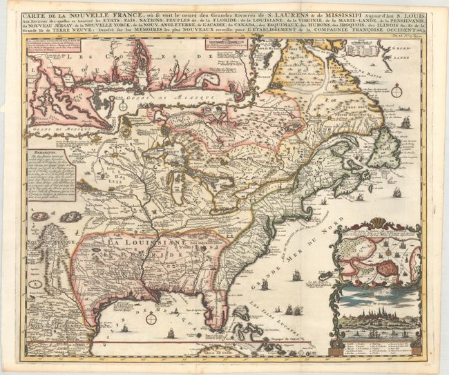
Auction 166, Lot 103
Subject: Colonial Eastern United States & Canada
Chatelain, Henry Abraham
Carte de la Nouvelle France, ou se Voit le Cours des Grandes Rivieres de S. Laurens & de Mississipi Aujour d'hui S. Louis, aux Environs des-quelles se Trouvent les Etats, Pais, Nations, Peuples &c..., 1719
Size: 19.2 x 16.6 inches (48.8 x 42.2 cm)
Estimate: $3,000 - $3,750
One of the Most Informative 18th Century Maps of the French Possessions in North America
Sold for: $3,250
Closed on 2/14/2018
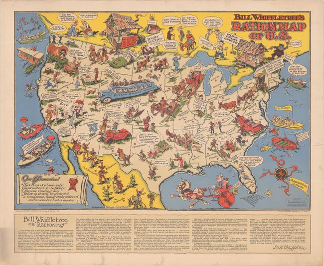
Auction 166, Lot 121
Subject: United States, World War II
[Lot of 2] Bill Whiffletree's Ration Map of U.S. [and] Bill Whiffletree's Bootleggers' Map of the United States, 1944
Size: 30.1 x 20.2 inches (76.5 x 51.3 cm)
Estimate: $3,000 - $4,000
Matching Pair Featuring the Extremely Rare "Ration Map"
Sold for: $2,000
Closed on 2/14/2018
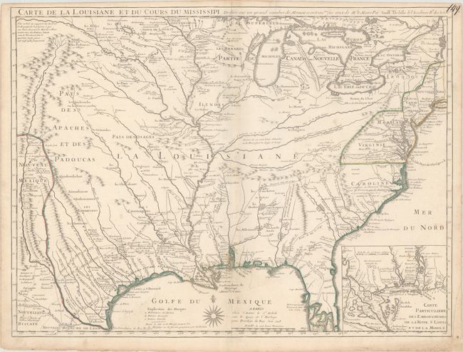
Auction 166, Lot 122
Subject: Colonial Eastern United States
Delisle, Guillaume
Carte de la Louisiane et du Cours du Mississipi Dressee sur un Grand Nombre de Memoires Entrautres sur ceux de Mr. le Maire, 1718
Size: 25.3 x 19.1 inches (64.3 x 48.5 cm)
Estimate: $7,500 - $9,000
A Foundation Map for the Mississippi Valley and the First Appearance of Texas on a Printed Map
Unsold
Closed on 2/14/2018
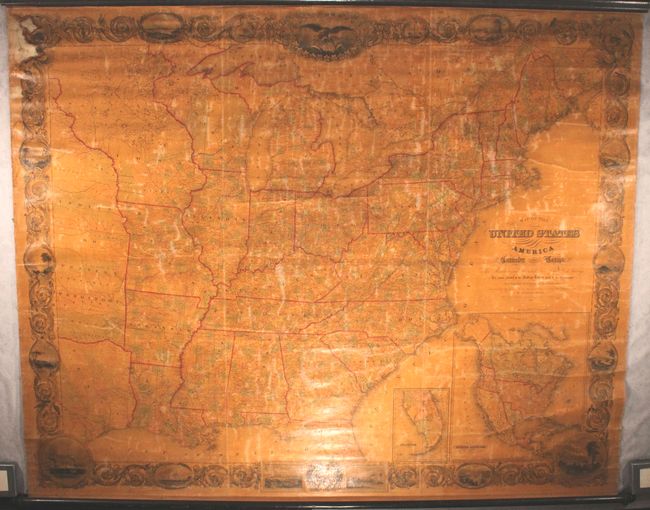
Auction 166, Lot 131
Subject: Eastern United States, Texas
Smith, J. Calvin
Map of the United States of America Including Canada and a Large Portion of Texas..., 1844
Size: 79 x 63 inches (200.7 x 160 cm)
Estimate: $3,500 - $4,500
Enormous Wall Map Featuring an Independent Texas
Sold for: $1,800
Closed on 2/14/2018
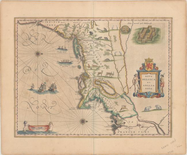
Auction 166, Lot 137
Subject: Colonial New England & Mid-Atlantic United States
Blaeu, Willem
Nova Belgica et Anglia Nova, 1642
Size: 19.9 x 15.3 inches (50.5 x 38.9 cm)
Estimate: $2,200 - $2,500
Important Map of Colonial New England and the Mid-Atlantic
Sold for: $1,600
Closed on 2/14/2018
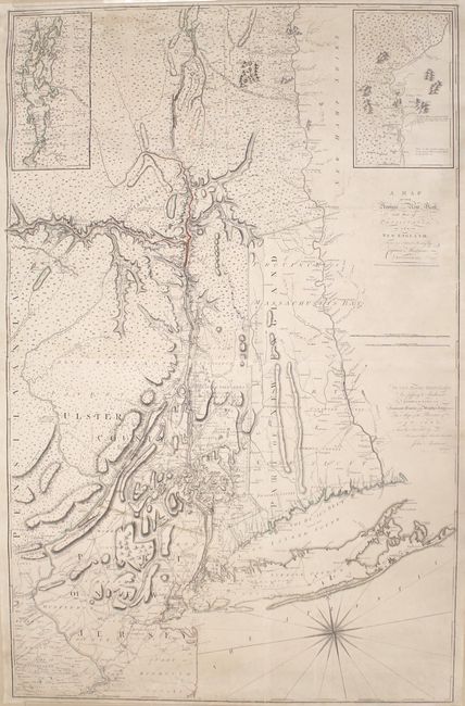
Auction 166, Lot 139
Subject: Colonial New England & Mid-Atlantic United States
Montresor, John
A Map of the Province of New York, with Part of Pensilvania, and New England..., 1775
Size: 36.5 x 56.7 inches (92.7 x 144 cm)
Estimate: $7,000 - $9,000
An Important Revolutionary War Period Map
Sold for: $5,000
Closed on 2/14/2018
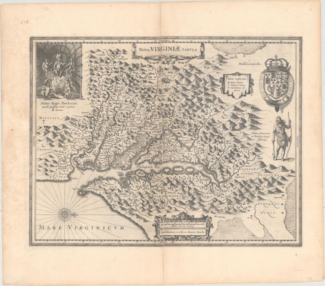
Auction 166, Lot 143
Subject: Colonial Mid-Atlantic United States
Hondius, Henricus
Nova Virginiae Tabula, 1652
Size: 19.4 x 15 inches (49.3 x 38.1 cm)
Estimate: $1,800 - $2,100
One of the Most Important 17th Century Maps of the Chesapeake Bay
Unsold
Closed on 2/14/2018
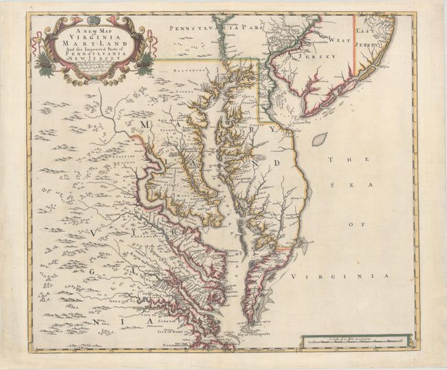
Auction 166, Lot 144
Subject: Colonial Mid-Atlantic United States
Browne/Senex
A New Map of Virginia Mary-land and the Improved Parts of Pennsylvania & New Jersey..., 1719
Size: 21.9 x 19.1 inches (55.6 x 48.5 cm)
Estimate: $4,750 - $6,000
Map of Chesapeake Bay Based on Landmark Herrman Map
Sold for: $3,500
Closed on 2/14/2018
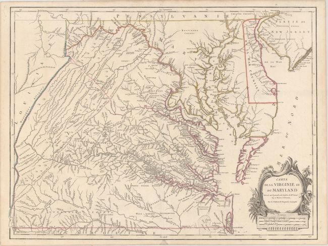
Auction 166, Lot 147
Subject: Mid-Atlantic United States
Robert de Vaugondy, Didier
Carte de la Virginie et du Maryland Dressee sur la Grande Carte Angloise de Mrs. Josue Fry et Pierre Jefferson, 1793
Size: 25.6 x 19.2 inches (65 x 48.8 cm)
Estimate: $2,200 - $2,500
An Essential Map of Virginia and Maryland
Sold for: $1,200
Closed on 2/14/2018
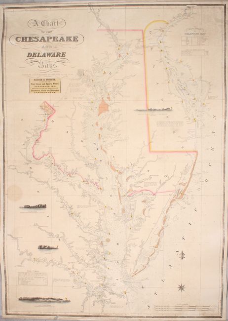
Auction 166, Lot 152
Subject: Mid-Atlantic United States, Chesapeake & Delaware Bays
Lucas, Fielding
A Chart of the Chesapeake and Delaware Bays, 1852
Size: 28.1 x 40.3 inches (71.4 x 102.4 cm)
Estimate: $6,000 - $7,500
Scarce Sea Chart of the Chesapeake and Delaware Bays
Unsold
Closed on 2/14/2018
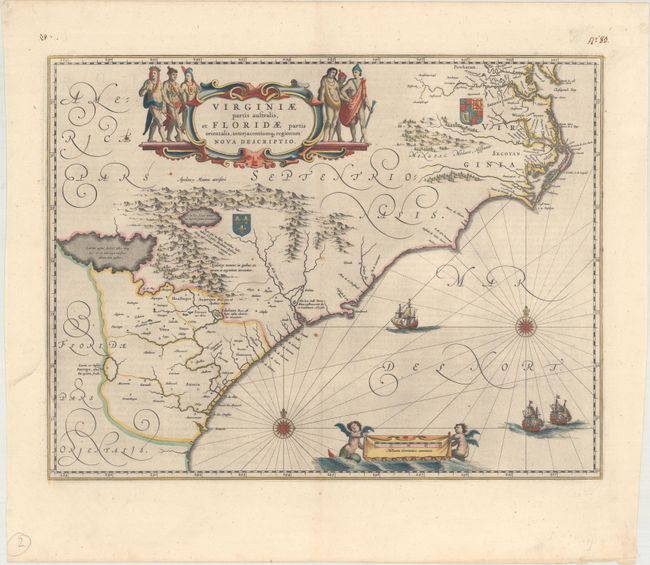
Auction 166, Lot 154
Subject: Colonial Southeastern United States
Blaeu, Willem
Virginiae Partis Australis, et Floridae Partis Orientalis, Interjacentiumq Regionum Nova Descriptio, 1643
Size: 19.8 x 15.2 inches (50.3 x 38.6 cm)
Estimate: $1,600 - $1,900
Blaeu's Decorative Map of the Southeast in Full Original Color
Sold for: $1,000
Closed on 2/14/2018
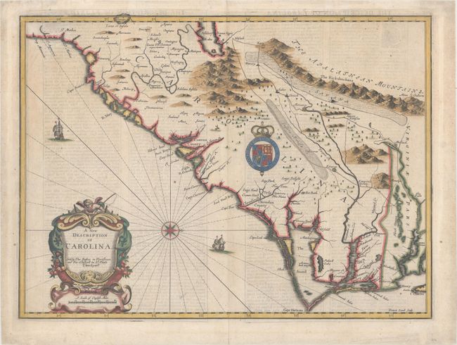
Auction 166, Lot 155
Subject: Colonial Southeastern United States
Speed/Lamb
A New Description of Carolina, 1676
Size: 20.2 x 14.9 inches (51.3 x 37.8 cm)
Estimate: $3,750 - $4,500
Speed's Map of the Carolinas Based Upon the Lords Proprietor's Map
Sold for: $2,100
Closed on 2/14/2018
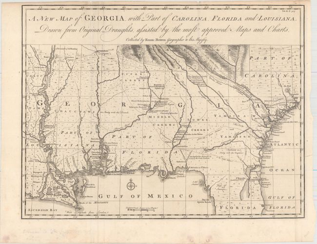
Auction 166, Lot 156
Subject: Colonial Southeastern United States
Bowen, Emanuel
A New Map of Georgia, with Part of Carolina, Florida and Louisiana. Drawn from Original Draughts, Assisted by the Most Approved Maps and Charts, 1748
Size: 18.8 x 14.3 inches (47.8 x 36.3 cm)
Estimate: $2,750 - $3,500
Important Map of the Georgia Colony
Unsold
Closed on 2/14/2018
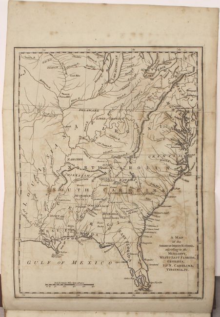
Auction 166, Lot 160
Subject: Colonial Southern United States
[Book with Map] The History of the American Indians; Particularly those Nations Adjoining to the Missisippi, East and West Florida, Georgia, South and North Carolina, and Virginia..., 1775
Size: 9.6 x 12.9 inches (24.4 x 32.8 cm)
Estimate: $4,000 - $5,000
Important History of Native Americans in the Southeast with Map
Unsold
Closed on 2/14/2018
Auction 166, Lot 174
Subject: Western United States
Longman Co.
The Travels of Capts. Lewis & Clarke, from St. Louis, by Way of the Missouri and Columbia Rivers, to the Pacific Ocean..., 1809
Size: 5.6 x 8.8 inches (14.2 x 22.4 cm)
Estimate: $4,000 - $5,000
A Counterfeit Account of the Lewis & Clark Expedition
Sold for: $3,000
Closed on 2/14/2018
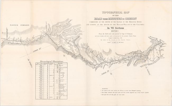
Auction 166, Lot 177
Subject: Western United States
Fremont/Preuss
[Lot of 7] Topographical Map of the Road from Missouri to Oregon Commencing at the Mouth of the Kansas in the Missouri River, and Ending at the Mouth of the Wallah Wallah in the Columbia. In VII Sections..., 1846
Size: 24.5 x 13 inches (62.2 x 33 cm)
Estimate: $3,250 - $4,000
Scarce Seven-Part Oregon Trail Map
Sold for: $2,000
Closed on 2/14/2018
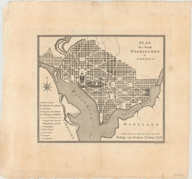
Auction 166, Lot 212
Subject: Washington, D.C.
Plan der Stadt Washington in America, 1796
Size: 9.9 x 8.4 inches (25.1 x 21.3 cm)
Estimate: $1,800 - $2,200
Extremely Rare Austrian Version of the Thackara & Vallance DC Map
Unsold
Closed on 2/14/2018
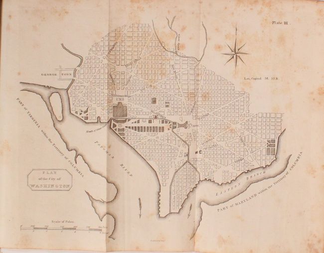
Auction 166, Lot 213
Subject: Washington, D.C.
Plan of the City of Washington [bound in] Encyclopaedia Perthensis; or Universal Dictionary of the Arts, Sciences, Literature, &c. ... Volume I, 1816
Size: 10.6 x 8.3 inches (26.9 x 21.1 cm)
Estimate: $800 - $950
Rare Scottish Plan of Washington, DC
Sold for: $500
Closed on 2/14/2018
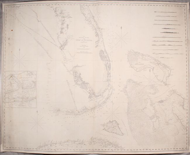
Auction 166, Lot 223
Subject: Florida
Blunt, Edmund
The Bahama Banks and Gulf of Florida, 1848
Size: 48.3 x 38.3 inches (122.7 x 97.3 cm)
Estimate: $1,600 - $2,000
Impressive Blueback Chart of the Florida Keys and Dry Tortugas
Sold for: $1,200
Closed on 2/14/2018
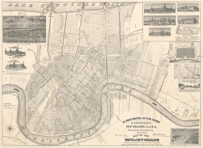
Auction 166, Lot 244
Subject: New Orleans, Louisiana
The World's Industrial and Cotton Centennial Exposition... Plan No. 2 Map of the City of New Orleans Showing Location of Exposition Grounds and All Approaches Thereto by Land & Water, 1884
Size: 36.7 x 26.7 inches (93.2 x 67.8 cm)
Estimate: $1,400 - $1,700
Scarce Pocket Map of New Orleans in Excellent Condition
Sold for: $800
Closed on 2/14/2018
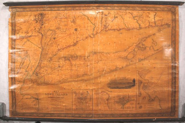
Auction 166, Lot 268
Subject: Long Island, New York
Smith, J. Calvin
Map of Long Island with the Environs of New-York, 1836
Size: 54 x 36 inches (137.2 x 91.4 cm)
Estimate: $1,600 - $2,000
Early, Large-Scale Map of Long Island
Sold for: $1,700
Closed on 2/14/2018
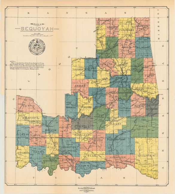
Auction 166, Lot 274
Subject: Oklahoma
U.S. Government
State of Sequoyah [with report] Proposed State of Sequoyah, 1906
Size: 14.8 x 16.2 inches (37.6 x 41.1 cm)
Estimate: $2,000 - $2,500
Scarce Map Featuring the Proposed State of Sequoyah with Official Report
Sold for: $1,800
Closed on 2/14/2018
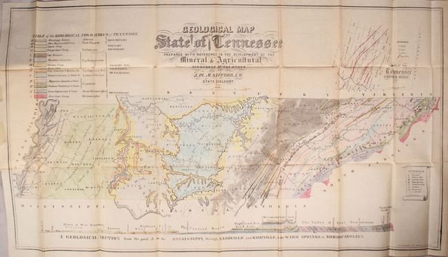
Auction 166, Lot 282
Subject: Tennessee
Geological Map of the State of Tennessee...[bound in] A Geological Reconnoissance of the State of Tennessee, 1856
Size: 38.5 x 21.4 inches (97.8 x 54.4 cm)
Estimate: $1,000 - $1,300
Rare, Early Geological Map of Tennessee
Sold for: $1,200
Closed on 2/14/2018
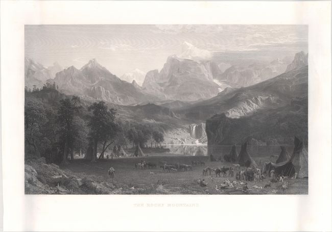
Auction 166, Lot 302
Subject: Rocky Mountains, Wyoming
The Rocky Mountains, 1866
Size: 27.8 x 18 inches (70.6 x 45.7 cm)
Estimate: $3,500 - $4,250
Stunning View of the Rocky Mountains and Native Indians by Albert Bierstadt
Unsold
Closed on 2/14/2018
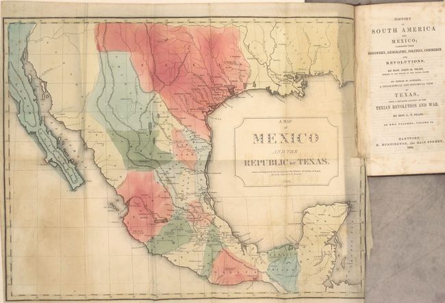
Auction 166, Lot 316
Subject: Texas, Mexico & South America
History of South America and Mexico; Comprising Their Discovery, Geography, Politics, Commerce and Revolutions ... A Geographical and Historical View of Texas, with a Detailed Account of the Texian Revolution and War..., 1844
Size: 5.1 x 8.1 inches (13 x 20.6 cm)
Estimate: $900 - $1,200
Important Contemporary Account of the Texas Revolution
Sold for: $650
Closed on 2/14/2018
25 lots