Subject: Colonial Southeastern United States
Period: 1748 (circa)
Publication: Harris' A Complete Collection of Voyages and Travels
Color: Black & White
Size:
18.8 x 14.3 inches
47.8 x 36.3 cm
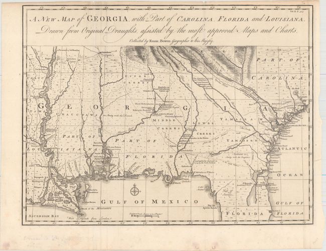
Scarce and important early map of colonial Georgia published shortly after the founding of the colony to accompany a new chapter on the history of Georgia for Harris' Voyages. The map covers from Charles Town to the Mississippi River and extends into Florida to C. Canaveral. The coastal settlements are well delineated, as are the Indian villages and forts (both French and English). The Indian tribes are noted as being friendly or hostile to the English. Major roads and trading paths are well depicted, many not found previously on a printed map. This was an entirely original production by Bowen, geographer to King George II of England and one of the leading English cartographers of the eighteenth century. One of the interesting things about this map is that it was used in a 1981 Supreme Court battle over the location of the boundary between Georgia and South Carolina at the mouth of the Savannah River. This map was presented as evidence of Georgia's claim that the boundary lies on the northern bank of the river.
References: Cumming (SE) #267; TMC, Issue 19, p.27-31.
Condition: A
A crisp impression with a few extraneous creases along the fold at left that have been pressed flat and several tiny edge tears confined to the blank margins closed on verso with archival materials. Minor marginal soiling.