Filtered by Category:United States(Show All Categories)
Showing results for:Auction 154
Catalog Archive
209 lots
Page 1 of 5
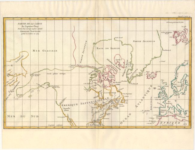
Auction 154, Lot 91
Subject: Colonial United States & Canada, Arctic
Robert de Vaugondy, Didier
Partie de la Carte du Capitaine Cluny Auteur d'un Ouvrage Anglois Intitule American Traveller Publie a ' Londres en 1769, 1772
Size: 19.2 x 11.6 inches (48.8 x 29.5 cm)
Estimate: $160 - $190
Sold for: $80
Closed on 9/16/2015
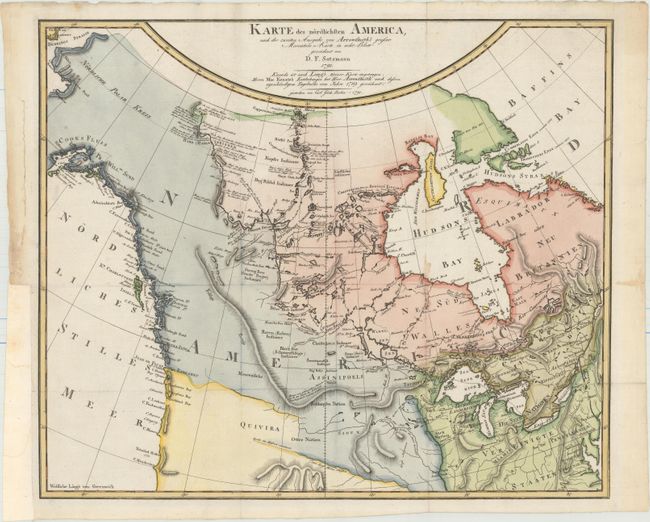
Auction 154, Lot 92
Subject: Canada & Northern United States
Sotzmann, Daniel Friedrich
Karte des Nordlichsten America, nach der Zweiten Ausgabe von Arrowsmith's Grosser Mercators-Karte in acht Blatt..., 1791
Size: 18.9 x 15.9 inches (48 x 40.4 cm)
Estimate: $1,000 - $1,300
Sold for: $600
Closed on 9/16/2015
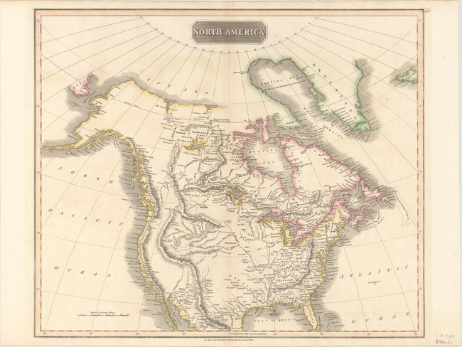
Auction 154, Lot 93
Subject: Canada & United States
Thomson, John
North America, 1814
Size: 23.5 x 19.7 inches (59.7 x 50 cm)
Estimate: $300 - $375
Sold for: $180
Closed on 9/16/2015
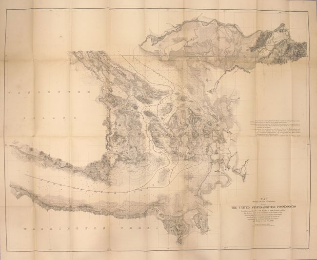
Auction 154, Lot 94
Subject: Canada & United States
U.S. Government
Map Showing the Line of Boundary between the United States & British Possessions..., 1868
Size: 36.1 x 28.2 inches (91.7 x 71.6 cm)
Estimate: $400 - $500
Sold for: $250
Closed on 9/16/2015
Auction 154, Lot 95
Subject: Canada & United States, Alaska
U.S. Government
[Papers Relating to the Treaty of Washington with 18 Folding Maps] I. Memorial on the Canal de Haro as the Boundary Line of the United States of America, Presented in the Name of the American Government to His Majesty William I..., 1872
Size: 5.9 x 9.1 inches (15 x 23.1 cm)
Estimate: $300 - $375
Sold for: $150
Closed on 9/16/2015
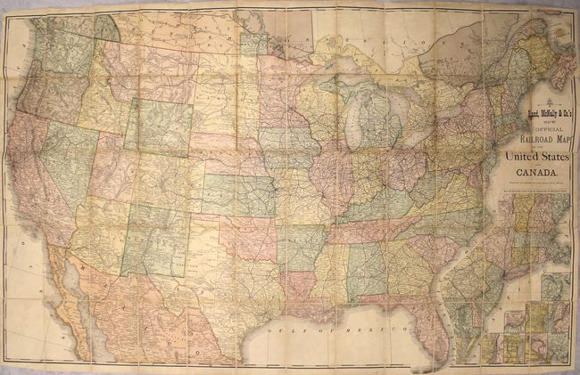
Auction 154, Lot 96
Subject: Canada & United States
Rand McNally & Co.
Rand, McNally & Co.'s New Official Railroad Map of the United States and Canada, 1880
Size: 43.4 x 27.4 inches (110.2 x 69.6 cm)
Estimate: $300 - $375
Sold for: $160
Closed on 9/16/2015
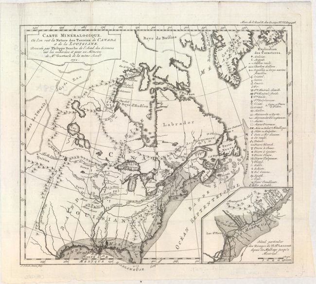
Auction 154, Lot 97
Subject: Colonial Eastern United States & Canada
Guettard, Jean Etienne
Carte Mineralogique, ou l'on voit la Nature des Terreins du Canada et de la Louisiane..., 1752
Size: 12.1 x 10.9 inches (30.7 x 27.7 cm)
Estimate: $1,200 - $1,500
First Geological Map of North America
Sold for: $900
Closed on 9/16/2015
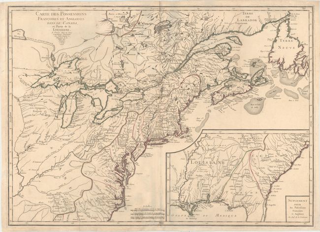
Auction 154, Lot 98
Subject: Colonial Eastern United States & Canada
Longchamp, S. G. (Sieur)
Carte des Possessions Francoises et Angloises dans le Canada, et Partie de la Louisiane, 1756
Size: 30 x 21.6 inches (76.2 x 54.9 cm)
Estimate: $1,600 - $1,900
First State of Longchamp's Map of the Theater of the French and Indian War
Sold for: $1,400
Closed on 9/16/2015
Auction 154, Lot 99
Subject: Colonial Eastern United States & Canada
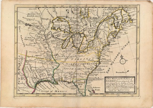
Moll, Herman
A New Map of Ye North Parts of America According to the Division Thereof by the Articles of Peace..., 1763
Size: 10.8 x 7.8 inches (27.4 x 19.8 cm)
Estimate: $550 - $650
Sold for: $400
Closed on 9/16/2015
Auction 154, Lot 100
Subject: Colonial Eastern United States & Canada
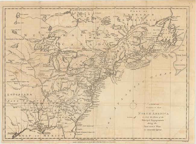
Lodge, John
A New and Correct Map of North America in Which the Places of the Principal Engagements During the Present War Are Accurately Inserted , 1780
Size: 15.1 x 10.9 inches (38.4 x 27.7 cm)
Estimate: $500 - $650
Sold for: $475
Closed on 9/16/2015
Auction 154, Lot 101
Subject: Colonial Eastern United States & Canada
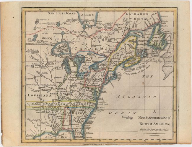
Cary, John
A New & Accurate Map of North America; from the Best Authorities, 1780
Size: 8.7 x 7.6 inches (22.1 x 19.3 cm)
Estimate: $140 - $170
Sold for: $100
Closed on 9/16/2015
Auction 154, Lot 102
Subject: Eastern United States & Canada
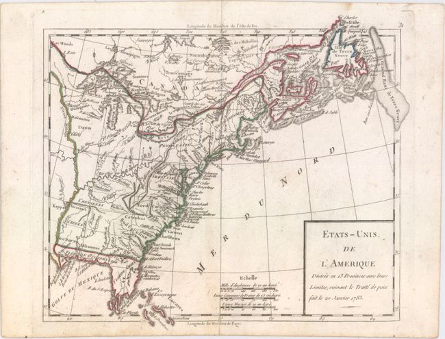
Robert de Vaugondy
Etats-Unis de l'Amerique Divises en 13 Provinces avec Leurs Limites, Suivant le Traite de Paix fait le 20 Janvier 1783, 1791
Size: 9.3 x 8.1 inches (23.6 x 20.6 cm)
Estimate: $200 - $230
Sold for: $110
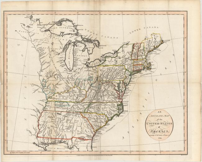
Closed on 9/16/2015
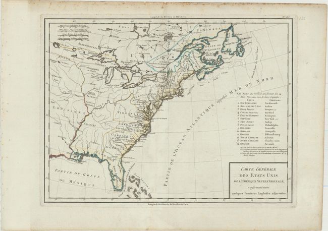
Auction 154, Lot 103
Subject: Eastern United States & Canada
Tardieu, Pierre Francois
Carte Generale des Etats Unis de l'Amerique Septentrionale, Renfermant Aussi Quelques Provinces Angloises Adjacentes, 1797
Size: 16.9 x 12.7 inches (42.9 x 32.3 cm)
Estimate: $350 - $450
Sold for: $190
Closed on 9/16/2015
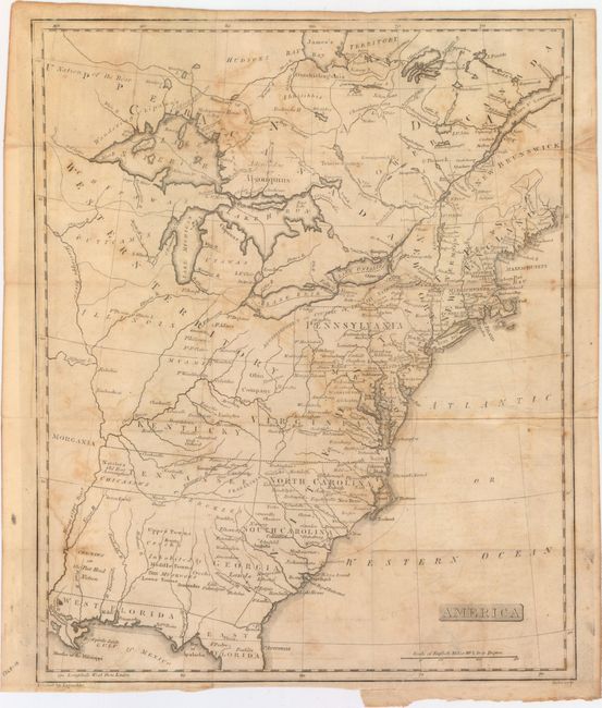
Auction 154, Lot 104
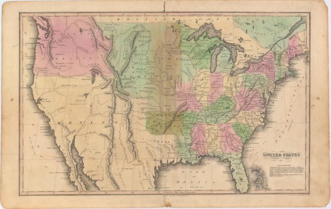
Subject: Eastern United States & Canada
Stansbury, A. J.
America, 1805
Size: 13 x 15.9 inches (33 x 40.4 cm)
Estimate: $400 - $500
Unique Map Depicting Both Franklinia and Morgania
Sold for: $650
Closed on 9/16/2015
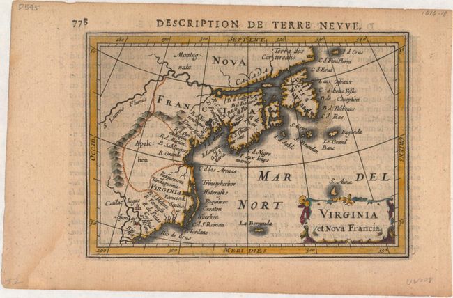
Auction 154, Lot 105
Subject: Colonial Northeastern United States & Canada
Hondius/Bertius
Virginia et Nova Francia, 1618
Size: 5.4 x 3.8 inches (13.7 x 9.7 cm)
Estimate: $550 - $700
Sold for: $400
Closed on 9/16/2015
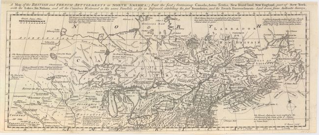
Auction 154, Lot 106
Subject: Colonial Northeastern United States & Canada
Bowen, Thomas
A Map of the British and French Settlements in North America; [Part the First] Containing Canada, Nova Scotia, New Found Land, New England, Part of New York..., 1755
Size: 19 x 7.4 inches (48.3 x 18.8 cm)
Estimate: $1,000 - $1,300
Sold for: $500
Closed on 9/16/2015
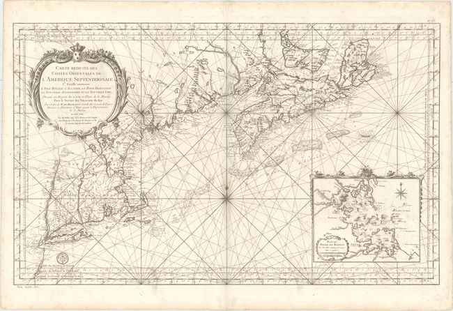
Auction 154, Lot 107
Subject: Colonial Northeastern United States & Canada
Bellin, Jacques Nicolas
Carte Reduite des Costes Orientales de l'Amerique Septentrionale 1re. Feuille Contenant l'Isle Royale, l'Accadie, la Bay Francoise, la Nouvelle Angleterre et la Nouvelle Yorc..., 1757
Size: 34.9 x 21.6 inches (88.6 x 54.9 cm)
Estimate: $2,400 - $3,000
Scarce Large-Scale Chart of the Coast of New England
Unsold
Closed on 9/16/2015
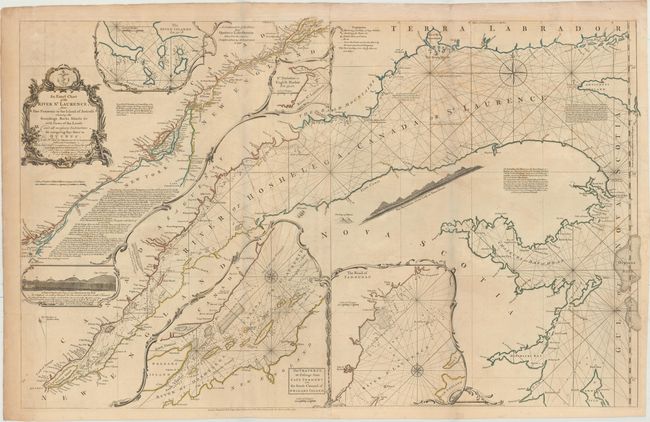
Auction 154, Lot 108
Subject: Colonial Northeastern United States & Canada
Jefferys/Sayer & Bennett
An Exact Chart of the River St. Laurence, from Fort Frontenac to the Island of Anticosti Shewing the Soundings, Rocks, Shoals &c..., 1775
Size: 37.4 x 23.7 inches (95 x 60.2 cm)
Estimate: $700 - $850
Sold for: $375
Closed on 9/16/2015
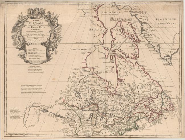
Auction 154, Lot 109
Subject: Colonial Northeastern United States & Canada, Great Lakes
Delisle/Dezauche
Carte du Canada qui Comprend la Partie Septentrionale des Etars Unis d'Amerique..., 1783
Size: 25.8 x 19.9 inches (65.5 x 50.5 cm)
Estimate: $750 - $900
Sold for: $400
Closed on 9/16/2015
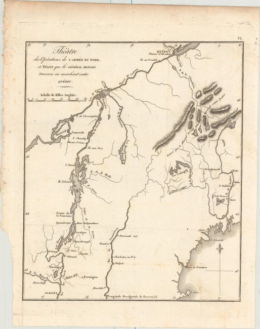
Auction 154, Lot 110
Subject: New England & Eastern Canada
Marshall, John
Theatre des Operations de l'Armee du Nord, et Desert que le General Arnold Traversa en Marchant Contre Quebec, 1807
Size: 8.4 x 10 inches (21.3 x 25.4 cm)
Estimate: $150 - $180
NO RESERVE
Unsold
Closed on 9/16/2015
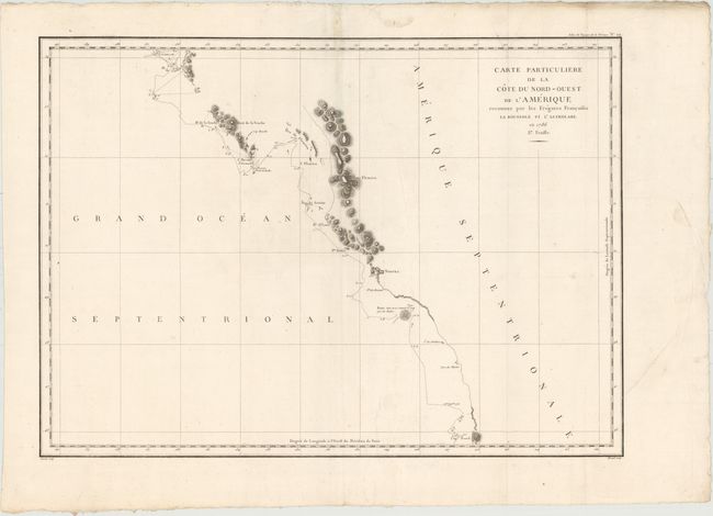
Auction 154, Lot 111
Subject: Western Canada & Alaska
La Perouse, Comte Jean F. Galoup, de
Carte Particuliere de la Cote du Nord-Ouest de l'Amerique Reconnue par les Fregates Francaises la Boussole et l'Astrolabe. En 1786 2e. Feuille, 1797
Size: 27 x 19.5 inches (68.6 x 49.5 cm)
Estimate: $120 - $160
Sold for: $60
Closed on 9/16/2015
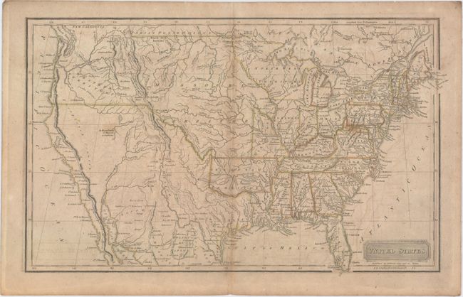
Auction 154, Lot 112
Subject: United States
Hilliard, Gray & Co.
United States, 1822
Size: 16.9 x 10.4 inches (42.9 x 26.4 cm)
Estimate: $275 - $350
Sold for: $125
Closed on 9/16/2015
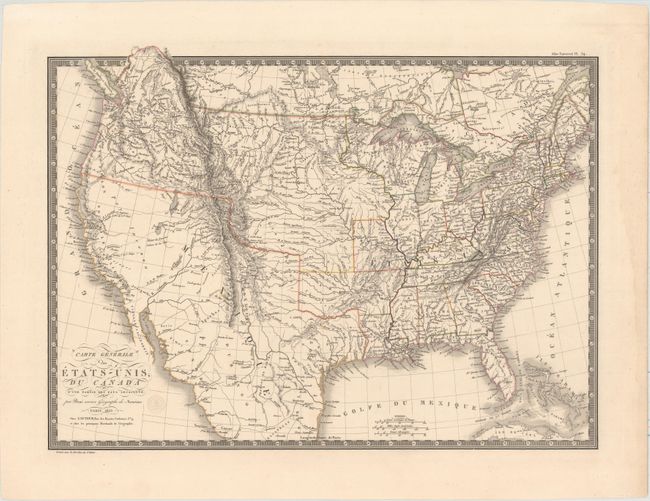
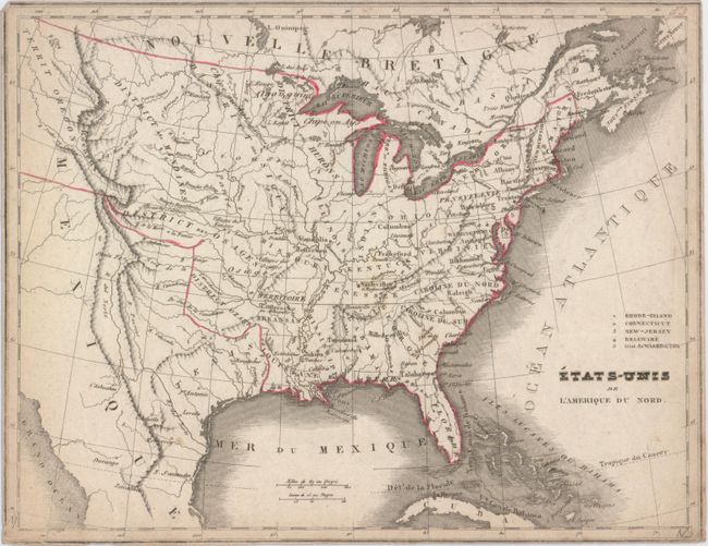
Auction 154, Lot 113
Subject: United States
Brue, Adrien Hubert
Carte Generale des Etats-Unis, du Canada et d'une Partie des Pays Adjacents, 1825
Size: 20 x 14.8 inches (50.8 x 37.6 cm)
Estimate: $400 - $475
Unsold
Closed on 9/16/2015
Auction 154, Lot 114
Subject: United States
[Lot of 2] United States [and] Map of the United States Canada and a Part of Mexico. To Illustrate Olney's School Geography, 1830-44
Size: See Description
Estimate: $300 - $375
Sold for: $175
Closed on 9/16/2015
Auction 154, Lot 115
Subject: United States
Hammond, J.T.
United States, 1833
Size: 16.6 x 10.3 inches (42.2 x 26.2 cm)
Estimate: $100 - $130
Sold for: $75
Closed on 9/16/2015
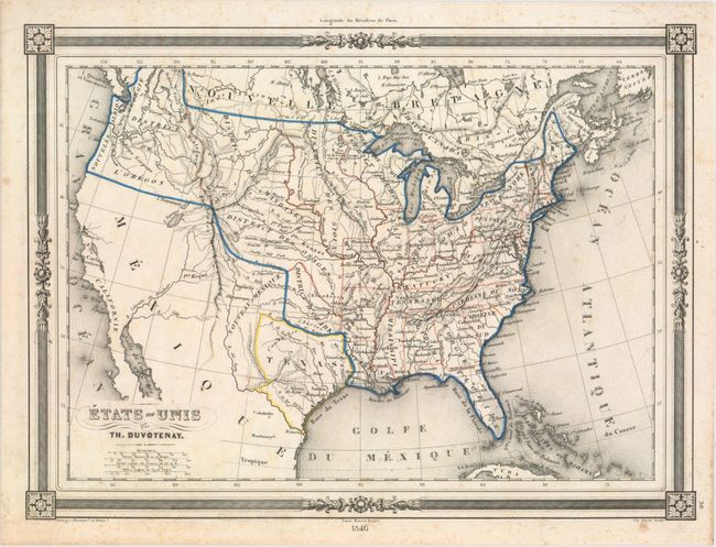
Auction 154, Lot 116
Subject: United States, Texas
Duvotenay, Thunot
Etats-Unis, 1846
Size: 12 x 8.8 inches (30.5 x 22.4 cm)
Estimate: $200 - $250
Sold for: $60
Closed on 9/16/2015
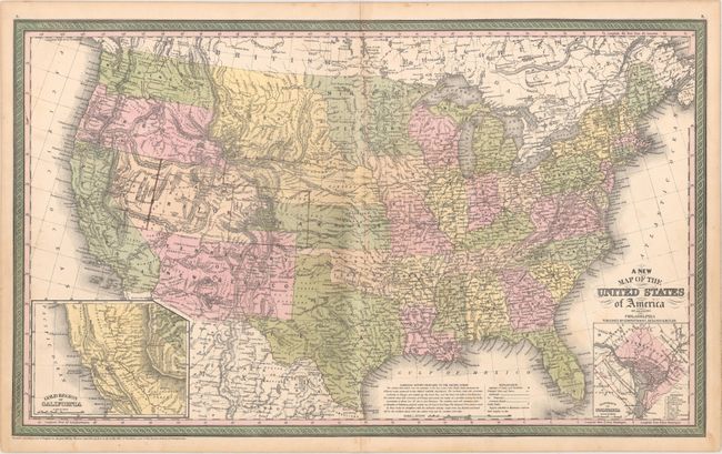
Auction 154, Lot 117
Subject: United States
Cowperthwait, Desilver & Butler
A New Map of the United States of America by J.H. Young, 1850
Size: 26.7 x 15.9 inches (67.8 x 40.4 cm)
Estimate: $275 - $350
Sold for: $200
Closed on 9/16/2015

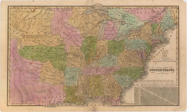
Auction 154, Lot 118
Subject: United States
U.S. Government
Map of the United States Exhibiting the Military Depts. & Posts, 1860
Size: 19.7 x 13 inches (50 x 33 cm)
Estimate: $200 - $250
Sold for: $150
Closed on 9/16/2015
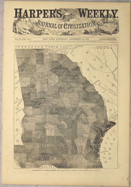
Auction 154, Lot 119
Subject: United States, Civil War
Harper's Weekly
[Lot of 14] Harper's Weekly. A Journal of Civilization Vol. V. - No. 247-261 , 1861
Size: 11.4 x 16.3 inches (29 x 41.4 cm)
Estimate: $200 - $250
Sold for: $100
Closed on 9/16/2015
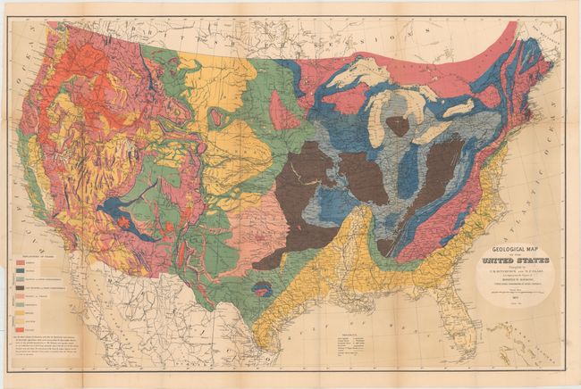
Auction 154, Lot 120
Subject: United States
Hitchcock, Charles Henry
Geological Map of the United States Compiled by C.H. Hitchcock and W. P. Blake…, 1873
Size: 33.5 x 21.5 inches (85.1 x 54.6 cm)
Estimate: $250 - $350
Sold for: $275
Closed on 9/16/2015
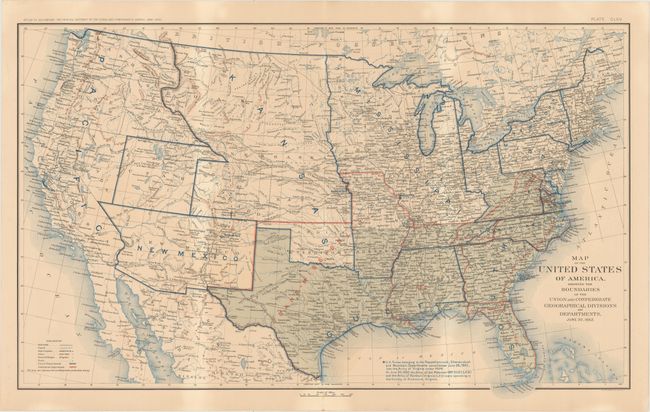
Auction 154, Lot 121
Subject: United States, Civil War, Flags
U.S. War Department
[Lot of 2] Map of the United States of America, Showing the Boundaries of the Union and Confederate Geographical Divisions and Departments, June, 30, 1862 [and] [Untitled - Flags of the Civil War], 1891-95
Size: 27.8 x 16.6 inches (70.6 x 42.2 cm)
Estimate: $200 - $230
Sold for: $150
Closed on 9/16/2015
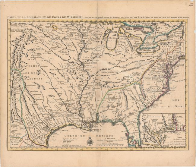
Auction 154, Lot 122
Subject: Colonial Eastern United States, Louisiana Territory
Delisle/Covens & Mortier
Carte de la Louisiane et du Cours du Mississipi Dressee sur un Grand Nombre de Memoires Entr' Autres sur Ceux de Mr. le Maire..., 1730
Size: 23.6 x 17.3 inches (59.9 x 43.9 cm)
Estimate: $2,750 - $3,500
Delisle's Influential Map of the Louisiana Territory
Unsold
Closed on 9/16/2015
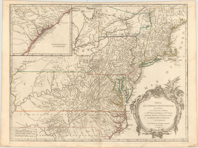
Auction 154, Lot 123
Subject: Colonial New England & Mid-Atlantic
Robert de Vaugondy, Didier
Partie de l'Amerique Septentrionale, qui Comprend le Cours de l'Ohio, la Nlle. Angleterre, la Nlle York, le New Jersey, la Pensylvanie, le Maryland la Virginie, la Caroline, 1755
Size: 24.6 x 18.9 inches (62.5 x 48 cm)
Estimate: $700 - $850
Unsold
Closed on 9/16/2015
Auction 154, Lot 124
Subject: Eastern United States
Russell, John C.
An Accurate Map of the United States of America, According to the Treaty of Peace of 1783, 1794
Size: 18.4 x 14.5 inches (46.7 x 36.8 cm)
Estimate: $600 - $700
Unsold
Closed on 9/16/2015
Auction 154, Lot 125
Subject: Eastern United States
[Lot of 2] Etats-Unis de l'Amerique du Nord, 1821-39
Size: See Description
Estimate: $140 - $170
Sold for: $40
Closed on 9/16/2015
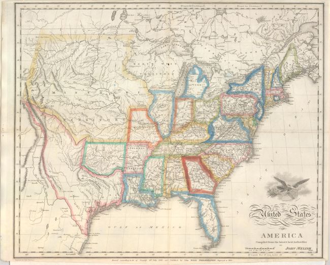
Auction 154, Lot 126
Subject: Eastern United States
Melish, John
United States of America Compiled from the Latest & Best Authorities, 1822
Size: 19.3 x 15.9 inches (49 x 40.4 cm)
Estimate: $900 - $1,100
Unsold
Closed on 9/16/2015
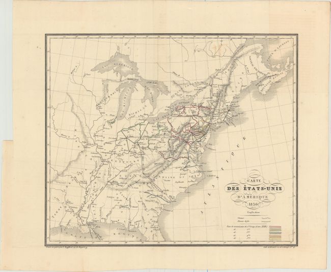
Auction 154, Lot 127
Subject: Eastern United States
Bouffard, L.
Carte des Etats-Unis d'Amerique, 1836
Size: 14.9 x 12.5 inches (37.8 x 31.8 cm)
Estimate: $190 - $220
Unsold
Closed on 9/16/2015
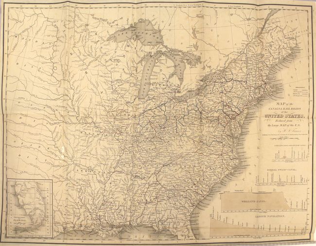
Auction 154, Lot 128
Subject: Eastern United States, Railroads
Tanner, Henry Schenck
[3 Maps In Book] A Description of the Canals and Rail Roads of the United States, Comprehending Notices of All the Works of Internal Improvement Throughout the Several States, 1840
Size: 5.9 x 9.5 inches (15 x 24.1 cm)
Estimate: $200 - $250
Sold for: $100
Closed on 9/16/2015
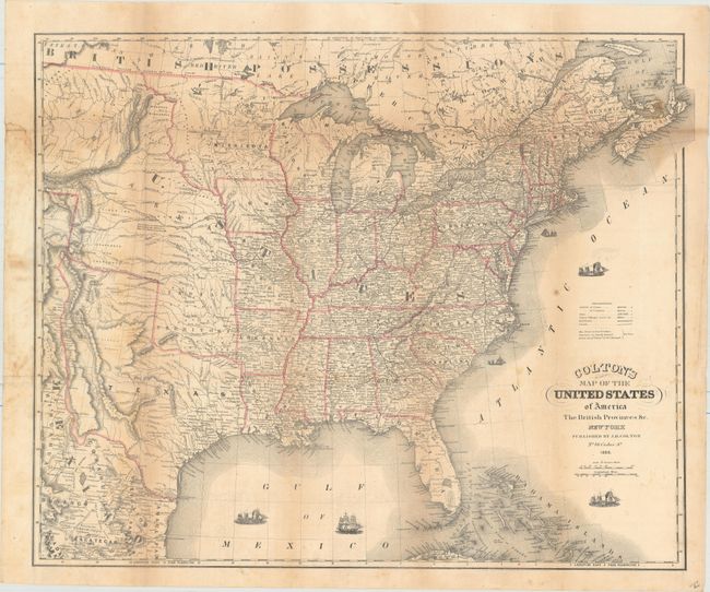
Auction 154, Lot 129
Subject: Eastern United States
Colton, Joseph Hutchins
Colton's Map of the United States of America the British Provinces &c., 1850
Size: 24.5 x 20.1 inches (62.2 x 51.1 cm)
Estimate: $350 - $450
Sold for: $240
Closed on 9/16/2015
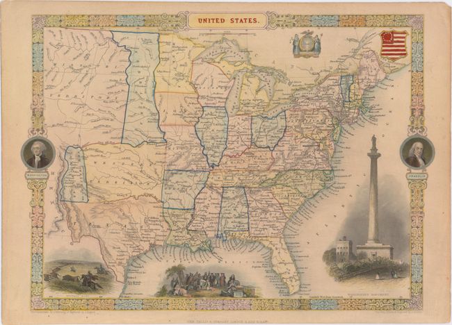
Auction 154, Lot 130
Subject: Eastern United States
Tallis, John
United States, 1851
Size: 13.4 x 9.7 inches (34 x 24.6 cm)
Estimate: $250 - $350
Sold for: $180
Closed on 9/16/2015
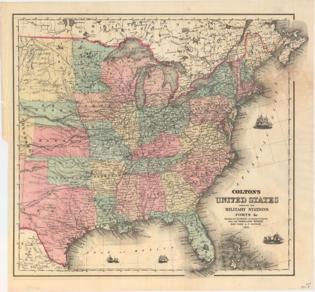
Auction 154, Lot 131
Subject: Eastern United States, Civil War
Colton, Joseph Hutchins
Colton's United States Shewing the Military Stations, Forts &c., 1861
Size: 16.3 x 14.5 inches (41.4 x 36.8 cm)
Estimate: $200 - $250
Sold for: $130
Closed on 9/16/2015
Auction 154, Lot 132
Subject: Colonial New England
Lotter, Tobias Conrad
[A Map of the Most Inhabited Part of New England - Northeast Quadrant], 1776
Size: 19.3 x 20.1 inches (49 x 51.1 cm)
Estimate: $800 - $950
Sold for: $400
Closed on 9/16/2015
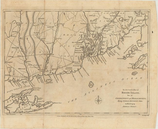
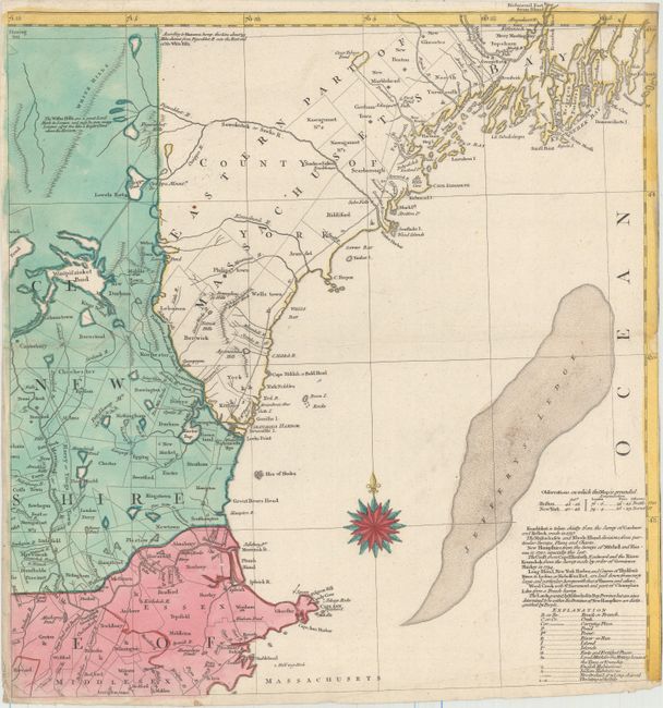
Auction 154, Lot 133
Subject: Colonial New England
Lodge, John
An Accurate Map of Rhode Island, Part of Connecticut and Massachusets, Shewing Admiral Arbuthnot's Station in Blocking up Admiral Ternay, 1780
Size: 14.8 x 10.5 inches (37.6 x 26.7 cm)
Estimate: $350 - $450
Sold for: $200
Closed on 9/16/2015
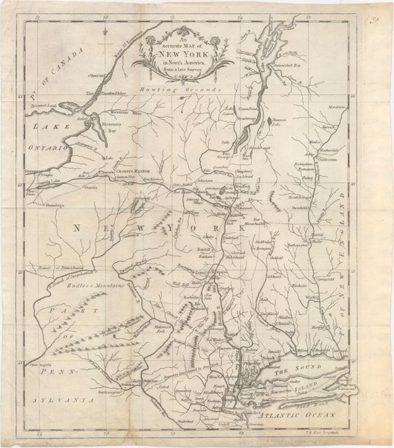
Auction 154, Lot 134
Subject: New England & New York
Anon.
An Accurate Map of New York in North America, from a Late Survey, 1780
Size: 10.6 x 13.1 inches (26.9 x 33.3 cm)
Estimate: $300 - $400
Unsold
Closed on 9/16/2015
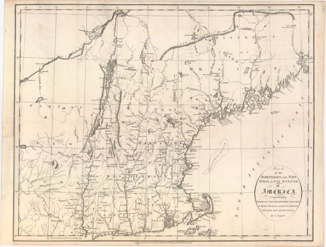
Auction 154, Lot 135
Subject: New England
Russell, John C.
Map of the Northern, or, New England States of America, Comprehending Vermont, New Hampshire, District of Main, Massachusetts, Rhode Island, and Connecticut, 1795
Size: 18.3 x 14.3 inches (46.5 x 36.3 cm)
Estimate: $350 - $450
Sold for: $250
Closed on 9/16/2015
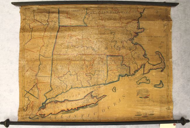
Auction 154, Lot 136
Subject: New England - United States
Ruggles, Edward
A Map of Massachusetts Connecticut and Rhodeisland..., 1824
Size: 36.3 x 28.7 inches (92.2 x 72.9 cm)
Estimate: $1,500 - $2,000
Ruggles' Rare Map of Southern New England
Sold for: $750
Closed on 9/16/2015
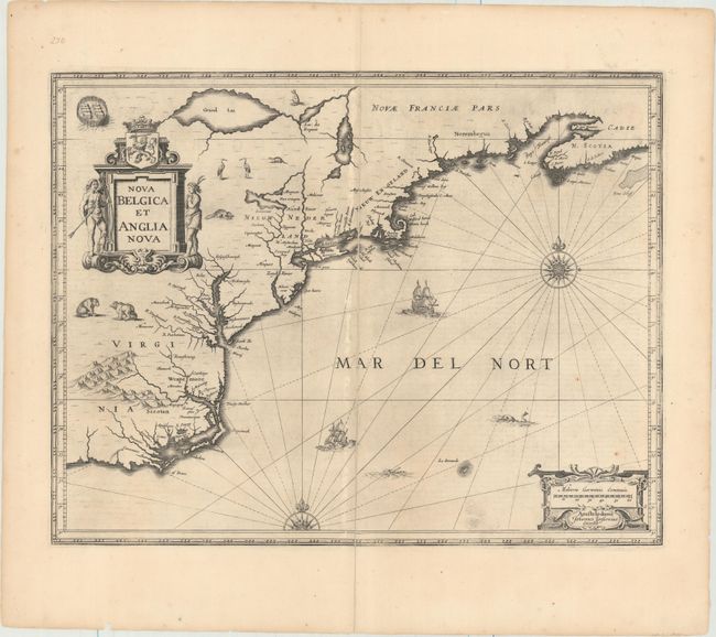
Auction 154, Lot 137
Subject: Colonial New England & Mid-Atlantic United States
Jansson, Jan
Nova Belgica et Anglia Nova, 1652
Size: 19.8 x 15.3 inches (50.3 x 38.9 cm)
Estimate: $1,600 - $1,900
Jansson's Influential Map of the East Coast
Sold for: $950
Closed on 9/16/2015
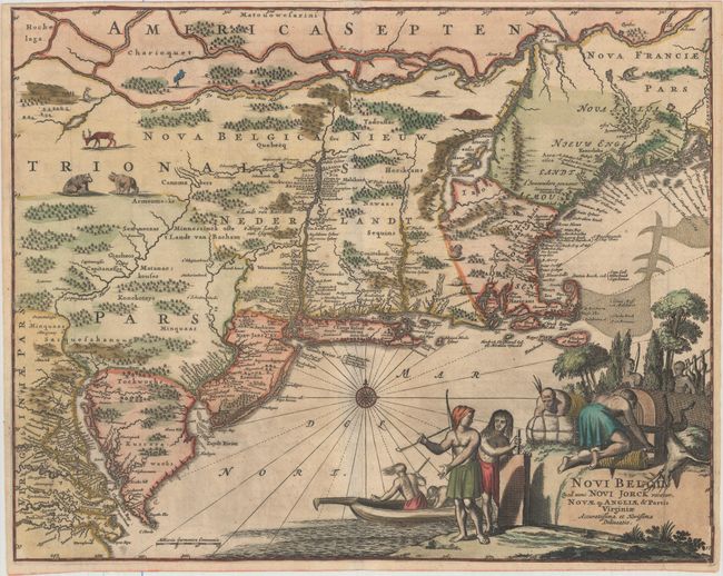
Auction 154, Lot 138
Subject: Colonial New England & Mid-Atlantic United States
Montanus, Arnoldus
Novi Belgii, quod nunc Novi Jorck Vocatur, Novae qz. Angliae & Partis Virginiae Accuratissima et Novissima Delineatio, 1671
Size: 14.6 x 11.5 inches (37.1 x 29.2 cm)
Estimate: $1,300 - $1,600
Sold for: $1,400
Closed on 9/16/2015
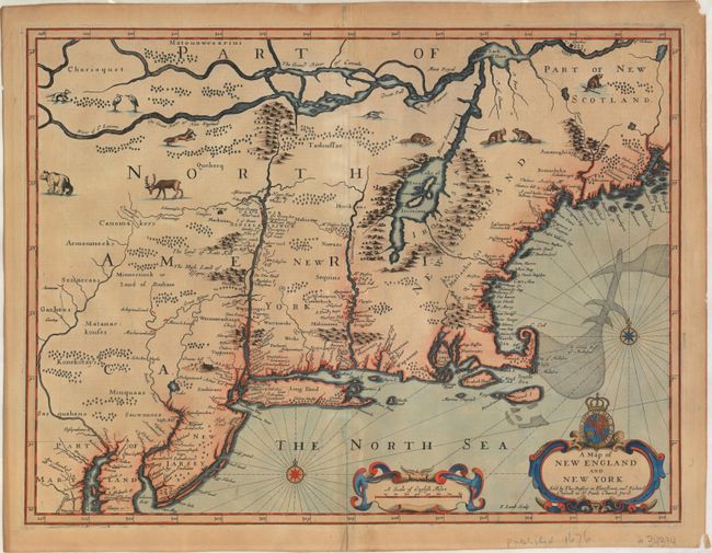
Auction 154, Lot 139
Subject: Colonial New England & Mid-Atlantic United States
Speed/Lamb
A Map of New England and New York, 1676
Size: 19.7 x 15 inches (50 x 38.1 cm)
Estimate: $4,500 - $5,500
"Speed" Map of New England
Sold for: $2,500
Closed on 9/16/2015
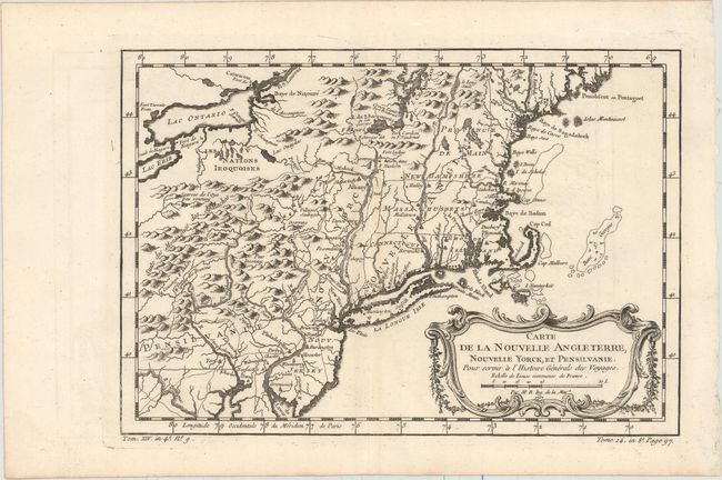
Auction 154, Lot 140
Subject: Colonial New England & Mid-Atlantic United States
Bellin, Jacques Nicolas
Carte de la Nouvelle Angleterre, Nouvelle Yorck, et Pensilvanie. Pour Servir a l'Histoire Generale des Voyages, 1757
Size: 11.8 x 8.1 inches (30 x 20.6 cm)
Estimate: $200 - $230
Sold for: $190
Closed on 9/16/2015
209 lots
Page 1 of 5