Subject: United States
Period: 1850 (dated)
Publication:
Color: Hand Color
Size:
26.7 x 15.9 inches
67.8 x 40.4 cm
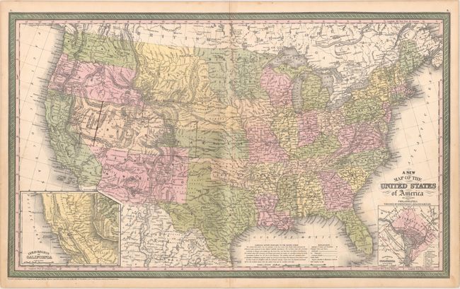
This fine map of the United States features an inset of the Gold Region of California and contains some of the largest western territorial boundaries. The large Kansas Territory borders Utah and New Mexico as there is no Colorado. Washington and Oregon both extend eastward to the Rocky Mountains and the Continental Divide. Utah and New Mexico are both shown at their largest configuration, with New Mexico occupying the entire Southwest. Minnesota Territory stretches to the Missouri River, which it shares as a boundary with a huge Nebraska Territory that extends north to the Canadian border and west to the Continental Divide in the Rocky Mountains. The map is filled with details and place names, forts, Indian Tribes, emigrant roads, and much more. Several exploration routes are shown, including those of Fremont, Marcy, and Kearney. The proposed routes for the "Great Pacific Railroad" are traced. A second inset contains a plan of the District of Columbia. The map still bears the copyright date of 1850, but was published circa 1857 with the new Gadsden Treaty Line 1854 delineated and Minnesota has yet to become a state (1858).
References:
Condition: B+
There is light toning along the centerfold, minor soiling, and a few manuscript borders drawn in the west.