Filtered by Category:Canada(Show All Categories)
Showing results for:Auction 154
Catalog Archive
30 lots
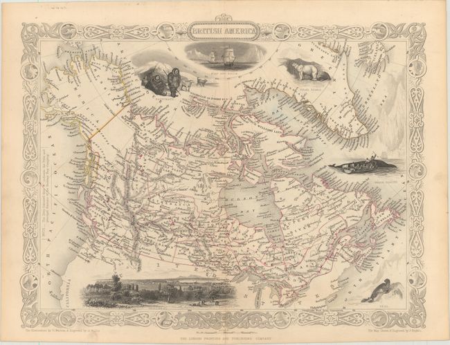
Auction 154, Lot 82
Subject: Canada & Alaska
Tallis, John
British America, 1850
Size: 12.9 x 10.1 inches (32.8 x 25.7 cm)
Estimate: $220 - $275
Sold for: $90
Closed on 9/16/2015
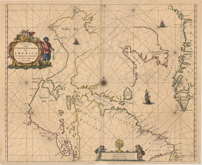
Auction 154, Lot 83
Subject: Eastern Canada and Greenland
Goos, Pieter
Paskaert Zynde de Noordelijckste Zeekusten van America van Groenland door de Straet Davis en de Straet Hudson tot Terra Neuf, 1666
Size: 21.4 x 17.5 inches (54.4 x 44.5 cm)
Estimate: $1,200 - $1,500
Goos' Uncommon Sea Chart Centered on Hudson Strait
Unsold
Closed on 9/16/2015
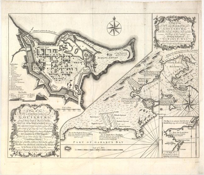
Auction 154, Lot 84
Subject: Eastern Canada, Louisburg
Gridley, Richard (Lt. Col.)
A Plan of the City & Fortifications of Louisburg… [on sheet with] A Plan of the City and Harbour of Louisburg…, 1758
Size: 14 x 10.5 inches (35.6 x 26.7 cm)
Estimate: $275 - $350
Unsold
Closed on 9/16/2015
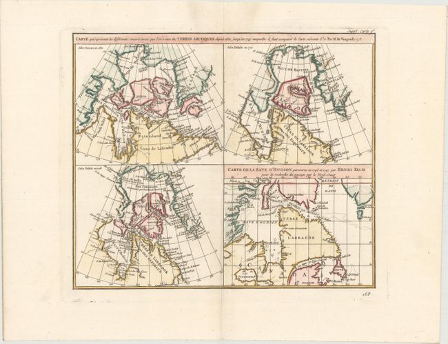
Auction 154, Lot 85
Subject: Eastern Canada
Robert de Vaugondy, Didier
Carte qui Represente les Differentes Connoissances que l'on a Eues des Terres Arctiques Depuis 1650 Jusqu'en 1747 Ausquelles il Faut Comparer la Carte Suivante, 1773
Size: 15.1 x 12 inches (38.4 x 30.5 cm)
Estimate: $140 - $170
Unsold
Closed on 9/16/2015
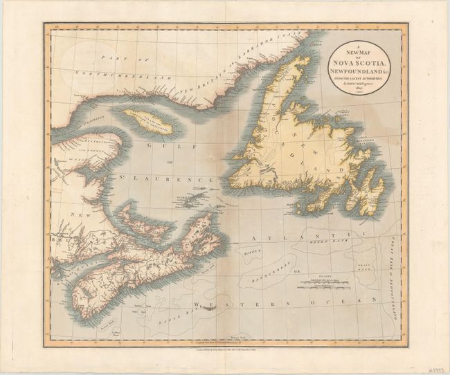
Auction 154, Lot 86
Subject: Eastern Canada
Cary, John
A New Map of Nova Scotia, Newfoundland &c. from the Latest Authorities, 1807
Size: 20.4 x 18.1 inches (51.8 x 46 cm)
Estimate: $240 - $325
Sold for: $120
Closed on 9/16/2015
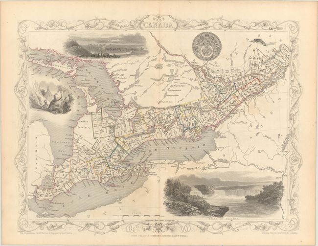
Auction 154, Lot 87
Subject: Eastern Canada
Tallis, John
[Lot of 3] West Canada [and] East Canada, and New Brunswick [and] Nova Scotia and Newfoundland, 1850
Size: 13 x 10 inches (33 x 25.4 cm)
Estimate: $300 - $375
Sold for: $150
Closed on 9/16/2015
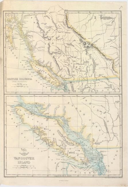
Auction 154, Lot 88
Subject: Western Canada
Weller, Edward
British Columbia (New Caledonia) [on sheet with] Vancouver Island, 1860
Size: 11.9 x 17.3 inches (30.2 x 43.9 cm)
Estimate: $120 - $150
Sold for: $60
Closed on 9/16/2015
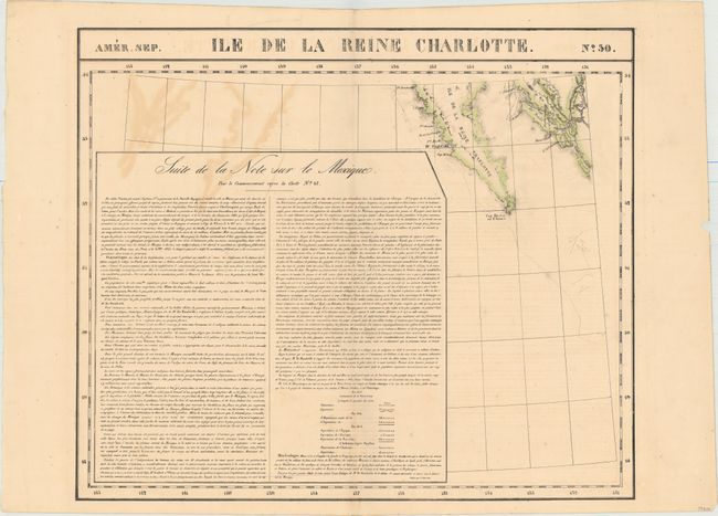
Auction 154, Lot 89
Subject: Northwestern Canada
Vandermaelen, Philippe Marie Guillaume
Amer. Sep. Ile de la Reine Charlotte. No. 30, 1825
Size: 22.8 x 19.3 inches (57.9 x 49 cm)
Estimate: $120 - $150
Sold for: $60
Closed on 9/16/2015
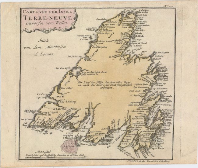
Auction 154, Lot 90
Subject: Newfoundland, Canada
Raspe, Gabriel Nikolaus
Carte von der Insel Terre-Neuve, 1763
Size: 9 x 8.9 inches (22.9 x 22.6 cm)
Estimate: $120 - $150
Unsold
Closed on 9/16/2015
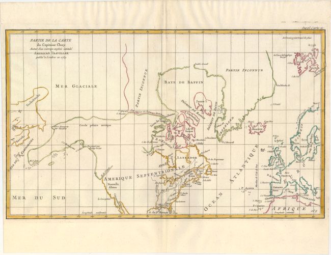
Auction 154, Lot 91
Subject: Colonial United States & Canada, Arctic
Robert de Vaugondy, Didier
Partie de la Carte du Capitaine Cluny Auteur d'un Ouvrage Anglois Intitule American Traveller Publie a ' Londres en 1769, 1772
Size: 19.2 x 11.6 inches (48.8 x 29.5 cm)
Estimate: $160 - $190
Sold for: $80
Closed on 9/16/2015
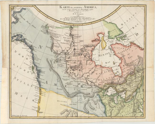
Auction 154, Lot 92
Subject: Canada & Northern United States
Sotzmann, Daniel Friedrich
Karte des Nordlichsten America, nach der Zweiten Ausgabe von Arrowsmith's Grosser Mercators-Karte in acht Blatt..., 1791
Size: 18.9 x 15.9 inches (48 x 40.4 cm)
Estimate: $1,000 - $1,300
Sold for: $600
Closed on 9/16/2015
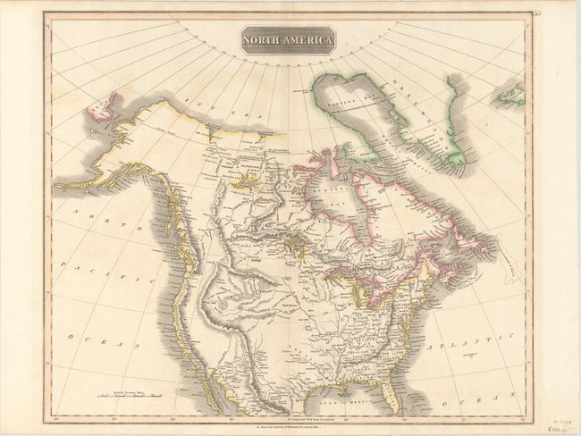
Auction 154, Lot 93
Subject: Canada & United States
Thomson, John
North America, 1814
Size: 23.5 x 19.7 inches (59.7 x 50 cm)
Estimate: $300 - $375
Sold for: $180
Closed on 9/16/2015
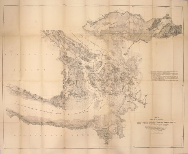
Auction 154, Lot 94
Subject: Canada & United States
U.S. Government
Map Showing the Line of Boundary between the United States & British Possessions..., 1868
Size: 36.1 x 28.2 inches (91.7 x 71.6 cm)
Estimate: $400 - $500
Sold for: $250
Closed on 9/16/2015
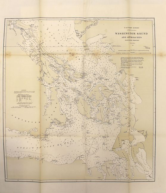
Auction 154, Lot 95
Subject: Canada & United States, Alaska
U.S. Government
[Papers Relating to the Treaty of Washington with 18 Folding Maps] I. Memorial on the Canal de Haro as the Boundary Line of the United States of America, Presented in the Name of the American Government to His Majesty William I..., 1872
Size: 5.9 x 9.1 inches (15 x 23.1 cm)
Estimate: $300 - $375
Sold for: $150
Closed on 9/16/2015
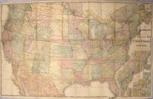
Auction 154, Lot 96
Subject: Canada & United States
Rand McNally & Co.
Rand, McNally & Co.'s New Official Railroad Map of the United States and Canada, 1880
Size: 43.4 x 27.4 inches (110.2 x 69.6 cm)
Estimate: $300 - $375
Sold for: $160
Closed on 9/16/2015
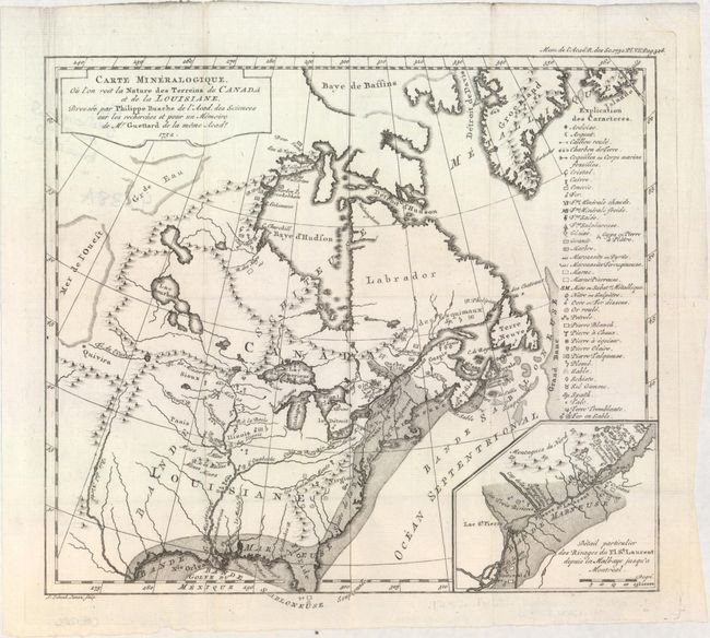
Auction 154, Lot 97
Subject: Colonial Eastern United States & Canada
Guettard, Jean Etienne
Carte Mineralogique, ou l'on voit la Nature des Terreins du Canada et de la Louisiane..., 1752
Size: 12.1 x 10.9 inches (30.7 x 27.7 cm)
Estimate: $1,200 - $1,500
First Geological Map of North America
Sold for: $900
Closed on 9/16/2015
Auction 154, Lot 98
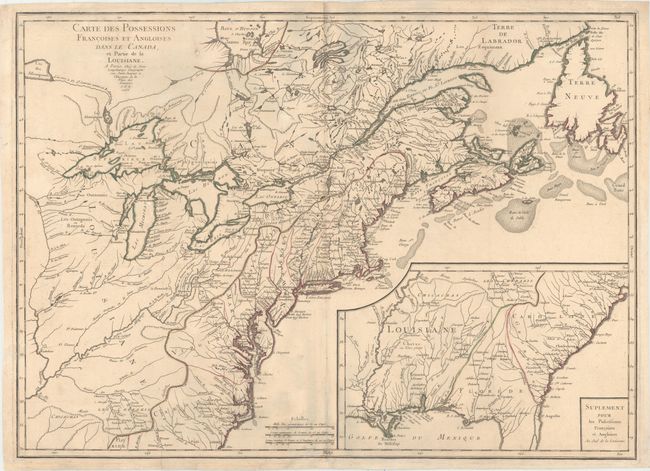
Subject: Colonial Eastern United States & Canada
Longchamp, S. G. (Sieur)
Carte des Possessions Francoises et Angloises dans le Canada, et Partie de la Louisiane, 1756
Size: 30 x 21.6 inches (76.2 x 54.9 cm)
Estimate: $1,600 - $1,900
First State of Longchamp's Map of the Theater of the French and Indian War
Sold for: $1,400
Closed on 9/16/2015
Auction 154, Lot 99
Subject: Colonial Eastern United States & Canada
Moll, Herman
A New Map of Ye North Parts of America According to the Division Thereof by the Articles of Peace..., 1763
Size: 10.8 x 7.8 inches (27.4 x 19.8 cm)
Estimate: $550 - $650
Sold for: $400
Closed on 9/16/2015
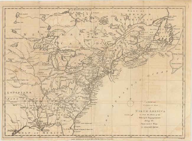
Auction 154, Lot 100
Subject: Colonial Eastern United States & Canada
Lodge, John
A New and Correct Map of North America in Which the Places of the Principal Engagements During the Present War Are Accurately Inserted , 1780
Size: 15.1 x 10.9 inches (38.4 x 27.7 cm)
Estimate: $500 - $650
Sold for: $475
Closed on 9/16/2015
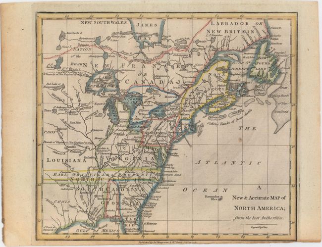
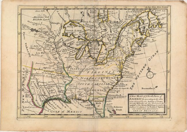
Auction 154, Lot 101
Subject: Colonial Eastern United States & Canada
Cary, John
A New & Accurate Map of North America; from the Best Authorities, 1780
Size: 8.7 x 7.6 inches (22.1 x 19.3 cm)
Estimate: $140 - $170
Sold for: $100
Closed on 9/16/2015
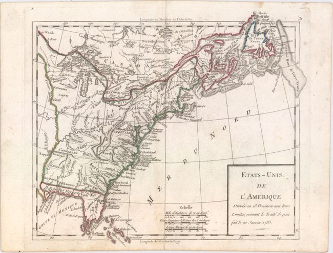
Auction 154, Lot 102
Subject: Eastern United States & Canada
Robert de Vaugondy
Etats-Unis de l'Amerique Divises en 13 Provinces avec Leurs Limites, Suivant le Traite de Paix fait le 20 Janvier 1783, 1791
Size: 9.3 x 8.1 inches (23.6 x 20.6 cm)
Estimate: $200 - $230
Sold for: $110
Closed on 9/16/2015
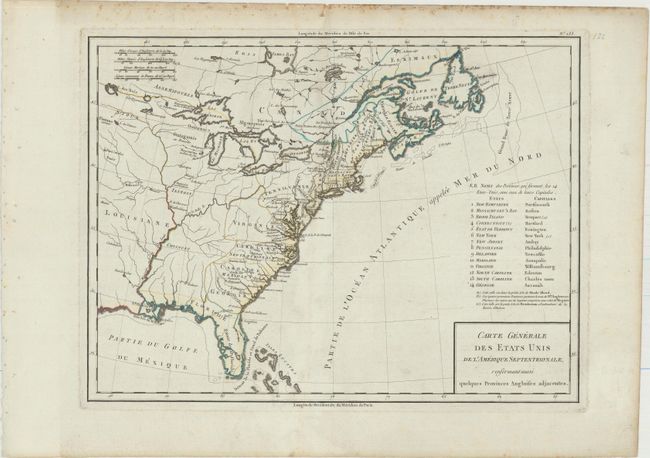
Auction 154, Lot 103
Subject: Eastern United States & Canada
Tardieu, Pierre Francois
Carte Generale des Etats Unis de l'Amerique Septentrionale, Renfermant Aussi Quelques Provinces Angloises Adjacentes, 1797
Size: 16.9 x 12.7 inches (42.9 x 32.3 cm)
Estimate: $350 - $450
Sold for: $190
Closed on 9/16/2015
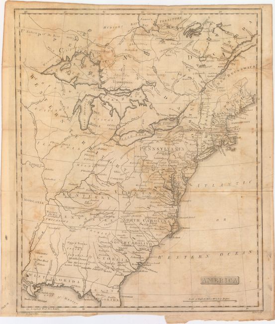
Auction 154, Lot 104
Subject: Eastern United States & Canada
Stansbury, A. J.
America, 1805
Size: 13 x 15.9 inches (33 x 40.4 cm)
Estimate: $400 - $500
Unique Map Depicting Both Franklinia and Morgania
Sold for: $650
Closed on 9/16/2015
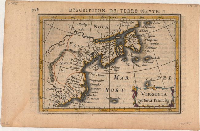
Auction 154, Lot 105
Subject: Colonial Northeastern United States & Canada
Hondius/Bertius
Virginia et Nova Francia, 1618
Size: 5.4 x 3.8 inches (13.7 x 9.7 cm)
Estimate: $550 - $700
Sold for: $400
Closed on 9/16/2015
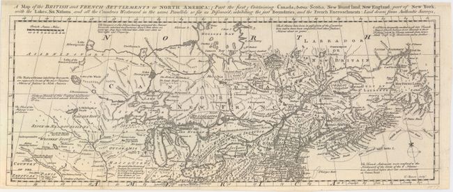
Auction 154, Lot 106
Subject: Colonial Northeastern United States & Canada
Bowen, Thomas
A Map of the British and French Settlements in North America; [Part the First] Containing Canada, Nova Scotia, New Found Land, New England, Part of New York..., 1755
Size: 19 x 7.4 inches (48.3 x 18.8 cm)
Estimate: $1,000 - $1,300
Sold for: $500
Closed on 9/16/2015
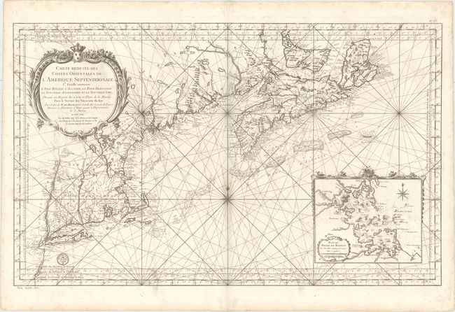
Auction 154, Lot 107
Subject: Colonial Northeastern United States & Canada
Bellin, Jacques Nicolas
Carte Reduite des Costes Orientales de l'Amerique Septentrionale 1re. Feuille Contenant l'Isle Royale, l'Accadie, la Bay Francoise, la Nouvelle Angleterre et la Nouvelle Yorc..., 1757
Size: 34.9 x 21.6 inches (88.6 x 54.9 cm)
Estimate: $2,400 - $3,000
Scarce Large-Scale Chart of the Coast of New England
Unsold
Closed on 9/16/2015
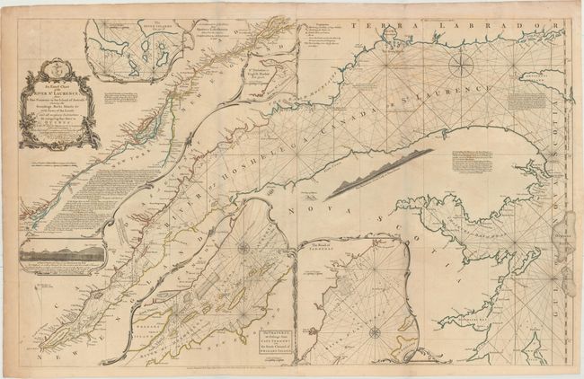
Auction 154, Lot 108
Subject: Colonial Northeastern United States & Canada
Jefferys/Sayer & Bennett
An Exact Chart of the River St. Laurence, from Fort Frontenac to the Island of Anticosti Shewing the Soundings, Rocks, Shoals &c..., 1775
Size: 37.4 x 23.7 inches (95 x 60.2 cm)
Estimate: $700 - $850
Sold for: $375
Closed on 9/16/2015
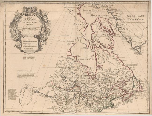
Auction 154, Lot 109
Subject: Colonial Northeastern United States & Canada, Great Lakes
Delisle/Dezauche
Carte du Canada qui Comprend la Partie Septentrionale des Etars Unis d'Amerique..., 1783
Size: 25.8 x 19.9 inches (65.5 x 50.5 cm)
Estimate: $750 - $900
Sold for: $400
Closed on 9/16/2015
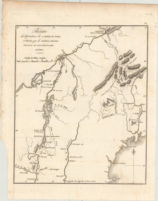
Auction 154, Lot 110
Subject: New England & Eastern Canada
Marshall, John
Theatre des Operations de l'Armee du Nord, et Desert que le General Arnold Traversa en Marchant Contre Quebec, 1807
Size: 8.4 x 10 inches (21.3 x 25.4 cm)
Estimate: $150 - $180
NO RESERVE
Unsold
Closed on 9/16/2015
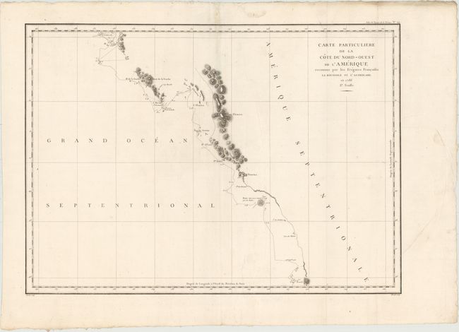
Auction 154, Lot 111
Subject: Western Canada & Alaska
La Perouse, Comte Jean F. Galoup, de
Carte Particuliere de la Cote du Nord-Ouest de l'Amerique Reconnue par les Fregates Francaises la Boussole et l'Astrolabe. En 1786 2e. Feuille, 1797
Size: 27 x 19.5 inches (68.6 x 49.5 cm)
Estimate: $120 - $160
Sold for: $60
Closed on 9/16/2015
30 lots