Subject: Colonial Northeastern United States & Canada, Great Lakes
Period: 1783 (dated)
Publication: Atlas Geographique Des Quatre Parties Du Monde
Color: Hand Color
Size:
25.8 x 19.9 inches
65.5 x 50.5 cm
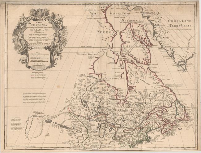
First issued by Guillaume Delisle in 1703, this richly detailed map provides the most accurate rendering of the Great Lakes of the time, with the lakes fully enclosed and properly placed in longitude and latitude. Delisle's map of Canada and the Great Lakes is one of the most outstanding and influential maps of the eighteenth century. It correctly positions the Ohio River but confuses its name with the Wabash River. West of the Mississippi, Lahontan's fictitious Riviere Longue is prominently depicted. In Canada, special attention is given to the rivers and lakes between Hudson Bay and the St. Lawrence, and Lac de Assenipoils (Lake Winnipeg) connects to Hudson Bay. Sanson's three islands of the Arctic are retained. The exquisite cartouche is decorated with a beaver, natives (one of whom is bearing a scalp), and Jesuit explorers. A table of colors below the cartouche distinguishes the boundaries of the United States and European possessions. This is the eighth state of the map, issued by Dezauche in 1783 and 1789, before nearly all traces of royalty were erased from the cartouche in the wake of the French Revolution. It is the first state to reflect the founding of the United States.
References: Kershaw # 315; Tooley (Amer) #42, p. 21.
Condition: B+
A fine impression with original outline color on a watermarked sheet with light soiling and a tiny hole at bottom near the centerfold. Professionally remargined at top with a portion of border replaced in facsimile.