Filtered by Category:United States(Show All Categories)
Showing results for:Auction 141
Catalog Archive
164 lots
Page 1 of 4
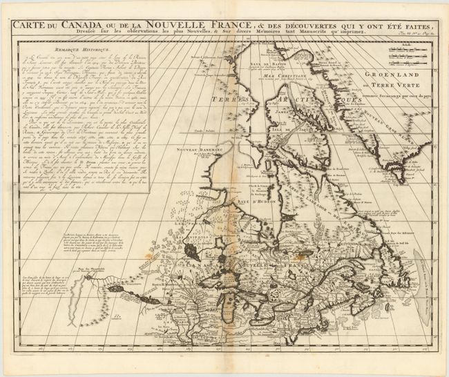
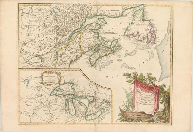
Auction 141, Lot 126
Subject: Colonial United States & Canada, Great Lakes
Chatelain, Henry Abraham
Carte du Canada ou de la Nouvelle France, & des Decouvertes qui y ont ete Faites, Dressee sur les Observations les Plus Nouvelles, & sur Divers Memoires Tant Manuscrits qu'Imprimez, 1719
Size: 20.5 x 16 inches (52.1 x 40.6 cm)
Estimate: $850 - $1,000
Sold for: $600
Closed on 9/5/2012
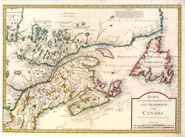
Auction 141, Lot 127
Subject: Colonial United States & Canada
Bellin, Jacques Nicolas
Karte von dem Ostlichen-Stucke von Neu Frankreich oder Canada, 1744
Size: 21.8 x 15.8 inches (55.4 x 40.1 cm)
Estimate: $400 - $500
Sold for: $275
Closed on 9/5/2012
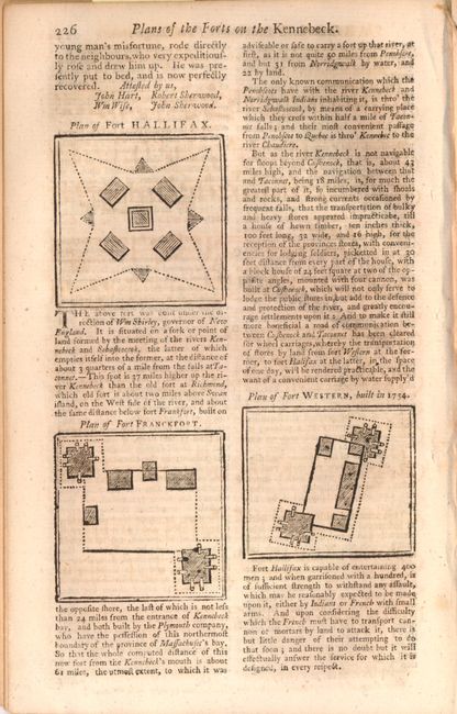
Auction 141, Lot 128
Subject: Colonial United States & Canada
Gentleman's Magazine
[Lot of 3 - Colonial Forts], 1755-59
Size: 5.5 x 8 inches (14 x 20.3 cm)
Estimate: $250 - $325
Sold for: $450
Closed on 9/5/2012
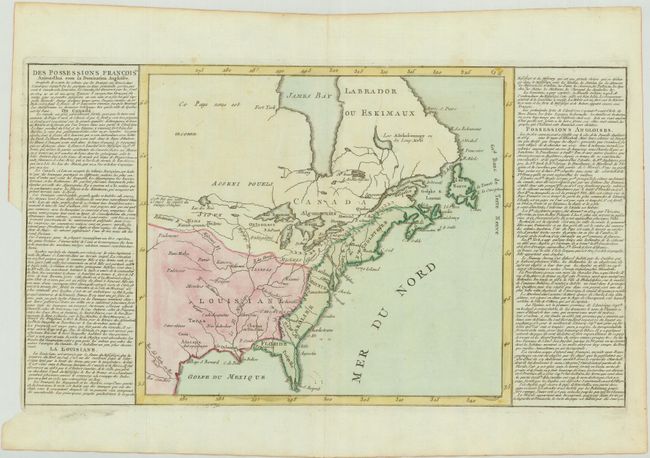
Auction 141, Lot 129
Subject: Colonial United States & Canada
Clouet, Jean Baptiste Louis
[Des Possessions Francoises Aujourd'hui sous la Domination Angloises ...], 1767
Size: 13.7 x 12.3 inches (34.8 x 31.2 cm)
Estimate: $250 - $325
Unsold
Closed on 9/5/2012
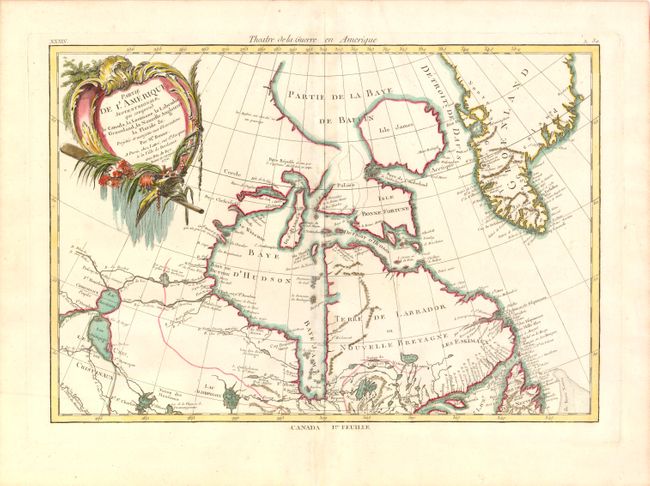
Auction 141, Lot 130
Subject: Colonial United States & Canada
Bonne/Lattre
[On 2 Sheets] Partie de l'Amerique Septentrionale, qui Comprend le Canada, la Louisiane, le Labrador, le Groenland, la Nouvelle Angleterre, la Floride &c., 1776
Size: 17 x 12.5 inches (43.2 x 31.8 cm)
Estimate: $550 - $750
Sold for: $425
Closed on 9/5/2012
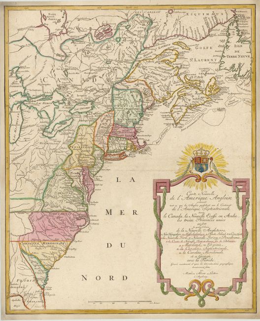
Auction 141, Lot 131
Subject: Colonial United States & Canada
Lotter, Mathias Albrecht
Carte Nouvelle de l'Amerique Angloise contenant tout ce que les Anglois Possedent sur le Continent de l'Amerique Septentrionale Savoir le Canada, la Nouvelle Ecosse ou Acadie, les Treize Provinces Unies…, 1776
Size: 19.5 x 23.8 inches (49.5 x 60.5 cm)
Estimate: $900 - $1,000
Sold for: $1,200
Closed on 9/5/2012
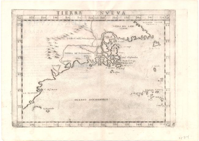
Auction 141, Lot 132
Subject: Eastern Canada & United States
Ruscelli, Girolamo
Tierra Nueva, 1574
Size: 10.3 x 7.5 inches (26.2 x 19.1 cm)
Estimate: $1,000 - $1,200
Unsold
Closed on 9/5/2012
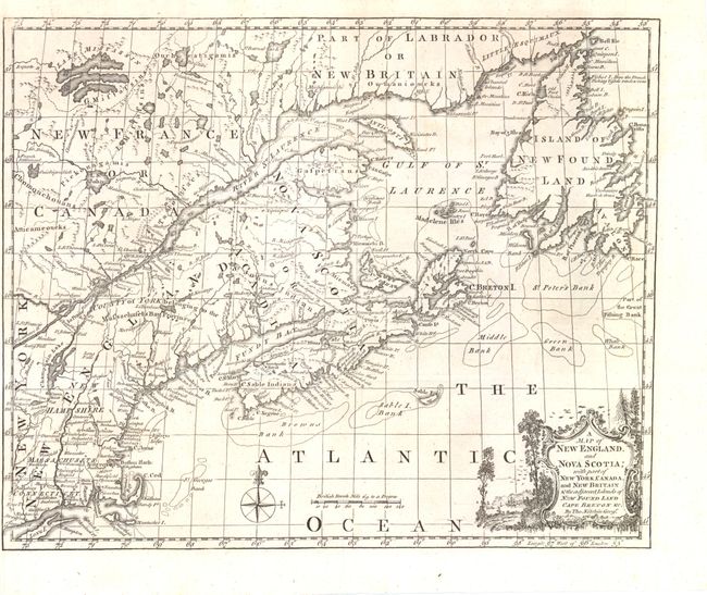
Auction 141, Lot 133
Subject: Colonial Eastern Canada & United States
Kitchin, Thomas
A Map of New England, and Nova Scotia; with Part of New York, Canada, and New Britain & the Adjacent Islands of New Found Land Cape Breton &c., 1758
Size: 13 x 10.8 inches (33 x 27.4 cm)
Estimate: $325 - $450
Unsold
Closed on 9/5/2012
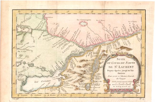
Auction 141, Lot 134
Subject: Colonial Lake Ontario & St. Lawrence River
Bellin, Jacques Nicolas
Suite du Cours du Fleuve de St. Laurent Depuis Quebec jusqu'au Lac Ontario pour Servir a l'Histoire Generale des Voyages, 1757
Size: 11.3 x 7.5 inches (28.7 x 19.1 cm)
Estimate: $140 - $180
Sold for: $100
Closed on 9/5/2012
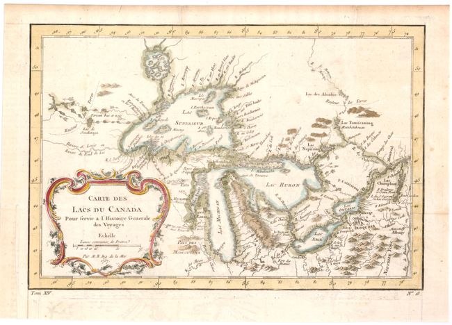
Auction 141, Lot 135
Subject: Colonial Canada and Great Lakes
Bellin, Jacques Nicolas
Carte des Lacs du Canada pour Servir a l'Histoire Generale des Voyages, 1757
Size: 11.5 x 7.7 inches (29.2 x 19.6 cm)
Estimate: $400 - $500
Sold for: $375
Closed on 9/5/2012
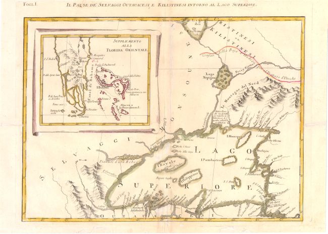
Auction 141, Lot 136
Subject: Colonial Great Lakes
Zatta, Antonio
Il Paese de' Selvaggi Outauacesi e Kilistinesi Intorno al Lago Superiore, 1778
Size: 16.5 x 12 inches (41.9 x 30.5 cm)
Estimate: $550 - $700
Sold for: $300
Closed on 9/5/2012
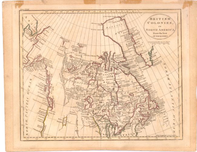
Auction 141, Lot 137
Subject: Canada and Alaska
Russell, John C.
British Colonies, in North America from the Best Authorities, 1798
Size: 8.8 x 7.1 inches (22.4 x 18 cm)
Estimate: $110 - $140
Sold for: $70
Closed on 9/5/2012
Auction 141, Lot 138
Subject: United States & Canada
Robert de Vaugondy
Partie de l'Amerique Septent? qui comprend la Nouvelle France ou le Canada, 1799
Size: 23.5 x 18.5 inches (59.7 x 47 cm)
Estimate: $800 - $950
Sold for: $500
Closed on 9/5/2012
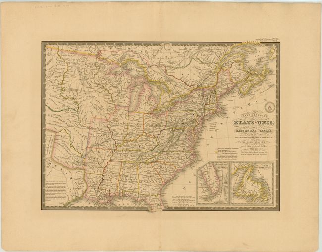
Auction 141, Lot 139
Subject: Canada & United States
Brue, Adrien Hubert
Carte Generale des Etats-Unis, des Haut et Bas-Canada…, 1832
Size: 20.3 x 14.5 inches (51.6 x 36.8 cm)
Estimate: $160 - $200
Unsold
Closed on 9/5/2012
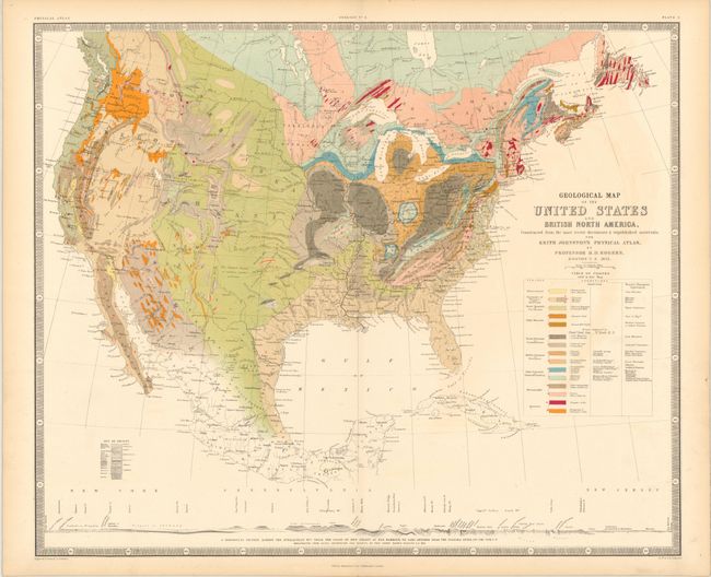
Auction 141, Lot 140
Subject: United States & Canada
Rogers, Henry Darwin
Geological Map of the United States and British North America…, 1855
Size: 24 x 20 inches (61 x 50.8 cm)
Estimate: $400 - $500
Sold for: $800
Closed on 9/5/2012
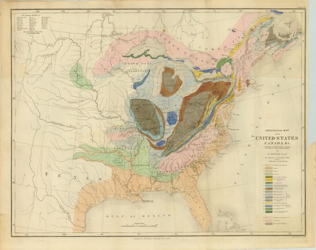
Auction 141, Lot 141
Subject: Eastern United States and Canada, Texas
Lyell, Charles
Geological Map of the United States Canada &c. Compiled from the State Surveys of the U.S. and Other Sources, 1845
Size: 19.5 x 15 inches (49.5 x 38.1 cm)
Estimate: $450 - $550
Sold for: $425
Closed on 9/5/2012
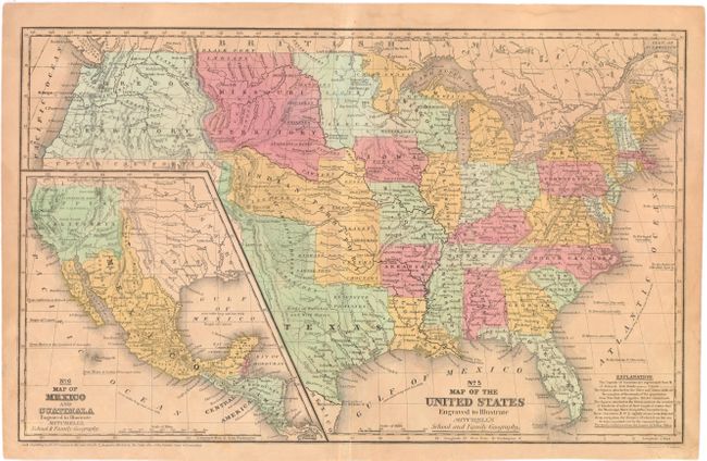
Auction 141, Lot 142
Subject: United States, Texas, Mexico
Mitchell, Samuel Augustus
No. 5 Map of the United States Engraved to Illustrate Mitchell's School and Family Geography, 1839
Size: 16.8 x 10.3 inches (42.7 x 26.2 cm)
Estimate: $180 - $220
Sold for: $130
Closed on 9/5/2012
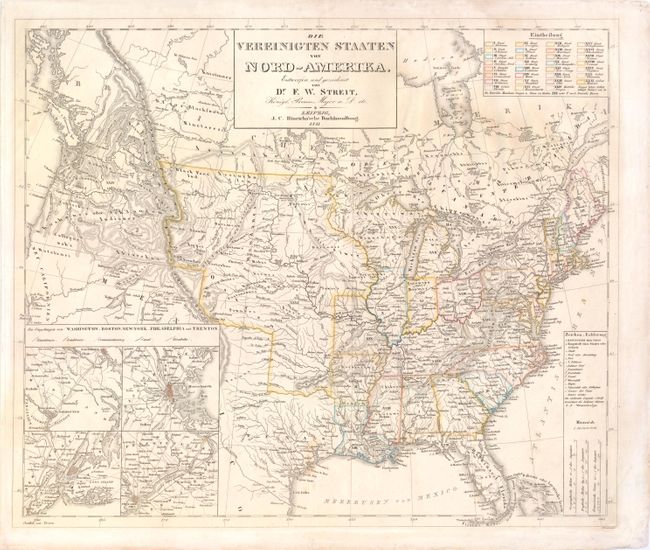
Auction 141, Lot 143
Subject: United States
Streit, Friedrich Wilhelm
Die Vereinigten Staaten von Nord-Amerika…, 1841
Size: 18.5 x 15.5 inches (47 x 39.4 cm)
Estimate: $230 - $300
Unsold
Closed on 9/5/2012
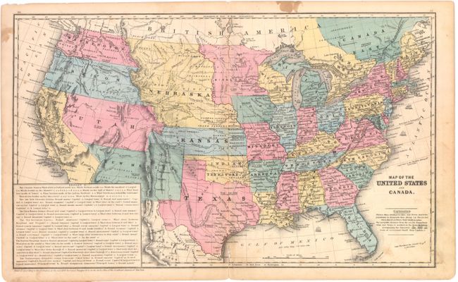
Auction 141, Lot 144
Subject: United States
Burgess, Daniel
Map of the United States and Canada, 1853
Size: 17.7 x 10.6 inches (45 x 26.9 cm)
Estimate: $80 - $100
Sold for: $60
Closed on 9/5/2012
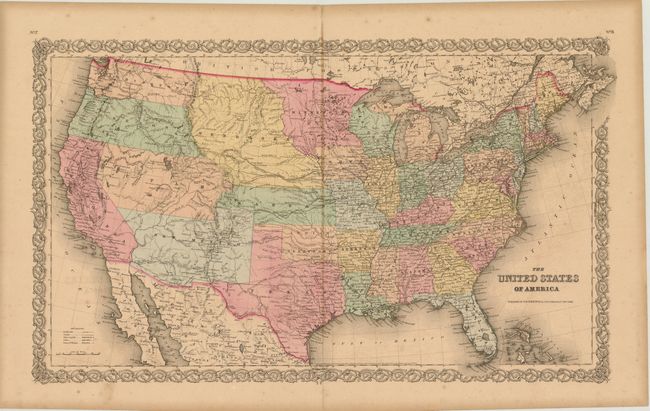
Auction 141, Lot 145
Subject: United States
Colton, Joseph Hutchins
The United States of America, 1855
Size: 25.5 x 15.8 inches (64.8 x 40.1 cm)
Estimate: $275 - $350
Sold for: $170
Closed on 9/5/2012
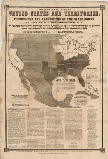
Auction 141, Lot 146
Subject: United States, Civil War
Map of the United States and Territories, Showing the Possessions and Aggressions of the Slave Power, 1856
Size: 26 x 42 inches (66 x 106.7 cm)
Estimate: $2,000 - $4,000
Fascinating and Rare Example of Political Propaganda and Thematic Mapping
Sold for: $4,750
Closed on 9/5/2012
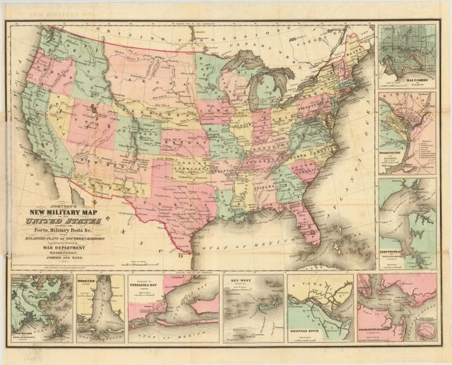
Auction 141, Lot 147
Subject: United States
Johnson & Ward
Johnson's New Military Map of the United States Showing the Forts, Military Posts &c. all the Military Divisions with Enlarged Plans of Southern Harbors…, 1861
Size: 23.5 x 17 inches (59.7 x 43.2 cm)
Estimate: $180 - $220
Sold for: $150
Closed on 9/5/2012
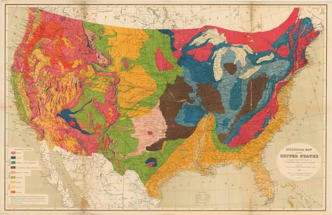
Auction 141, Lot 148
Subject: United States
Hitchcock, Charles Henry
Geological Map of the United States [with report] Ninth Census-Volume III. The Statistics of the Wealth and Industry of the United States…, 1872
Size: 9.5 x 12 inches (24.1 x 30.5 cm)
Estimate: $600 - $700
Unsold
Closed on 9/5/2012
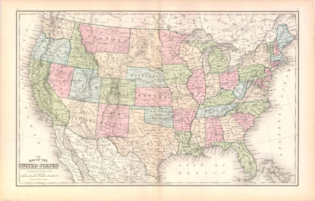
Auction 141, Lot 149
Subject: United States
Mitchell, Samuel Augustus
VII Map of the United States, 1889
Size: 17.3 x 10.8 inches (43.9 x 27.4 cm)
Estimate: $100 - $130
Unsold
Closed on 9/5/2012
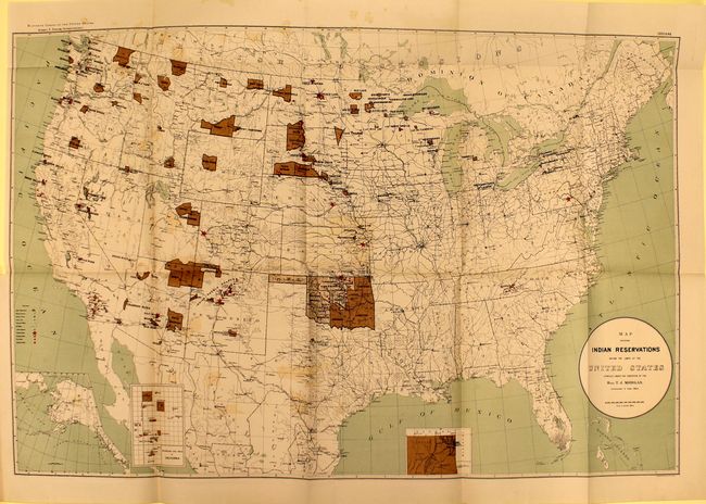
Auction 141, Lot 150
Subject: United States
U.S. Government
[Lot of 2] Map Showing Indian Reservations within the Limits of the United States [and] Map of Linguistic Stocks of American Indians Chiefly within the Present Limits of the United States, 1890-94
Size: See Description
Estimate: $250 - $350
Sold for: $160
Closed on 9/5/2012
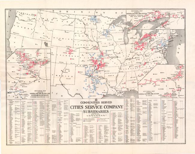
Auction 141, Lot 151
Subject: United States
Anon.
Communities Served by Cities Service Company Subsidiaries, 1919
Size: 19.8 x 15 inches (50.3 x 38.1 cm)
Estimate: $100 - $130
Sold for: $140
Closed on 9/5/2012
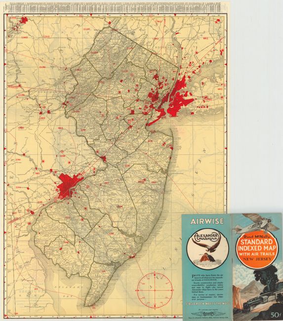
Auction 141, Lot 152
Subject: United States
Rand McNally & Co.
[Lot of 46] Rand McNally Standard Indexed Map with Air Trails, 1929-30
Size: 18.5 x 26 inches (47 x 66 cm)
Estimate: $1,200 - $1,500
Rare Rand McNally "Air Trails" Pocket Maps
Unsold
Closed on 9/5/2012
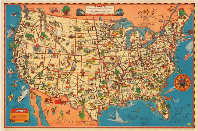
Auction 141, Lot 153
Subject: United States
A Good-Natured Map of the United States Setting Forth the Services of The Greyhound Lines and a Few Principle Connecting Bus Lines, 1937
Size: 29.3 x 19.5 inches (74.4 x 49.5 cm)
Estimate: $140 - $200
Pictographic Map of Greyhound Bus Lines
Sold for: $425
Closed on 9/5/2012
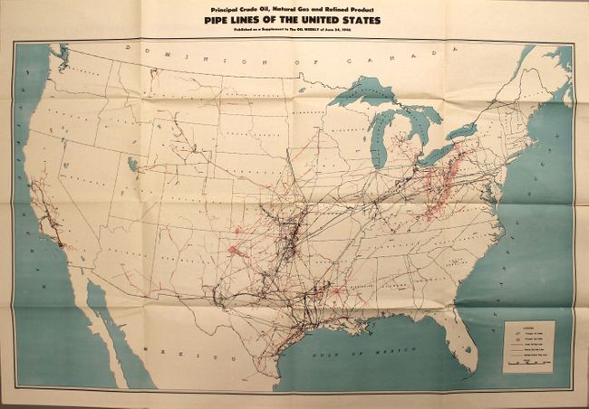
Auction 141, Lot 154
Subject: United States
Anon.
Principal Crude Oil, Natural Gas and Refined Product Pipe Lines of the United States…, 1946
Size: 42 x 28 inches (106.7 x 71.1 cm)
Estimate: $150 - $200
Sold for: $150
Closed on 9/5/2012
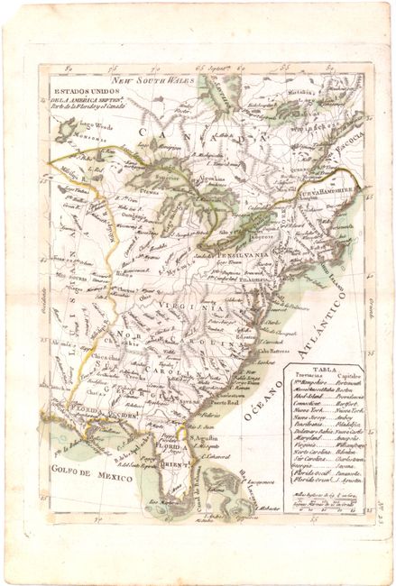
Auction 141, Lot 155
Subject: Eastern United States
Lopez de Vargas Machuca, Thomas (don)
Estados Unidos de la America Septenl. Parte de la Floriday el Canada, 1792
Size: 7.1 x 9.6 inches (18 x 24.4 cm)
Estimate: $275 - $350
Unsold
Closed on 9/5/2012
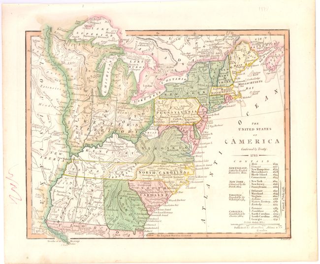
Auction 141, Lot 156
Subject: Eastern United States
Wilkinson, Robert
The United States of America Confirmed by Treaty 1783, 1806
Size: 11 x 9.3 inches (27.9 x 23.6 cm)
Estimate: $550 - $700
Early Map of the United States Featuring Franklinia and the Indiana Land Company
Sold for: $650
Closed on 9/5/2012
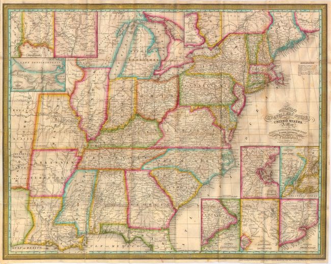
Auction 141, Lot 157
Subject: Eastern United States
Mitchell, Samuel Augustus
Mitchell's Travellers Guide Through the United States. A Map of the Roads, Distances, Steam Boat & Canal Routes &c., 1835
Size: 21.8 x 17.3 inches (55.4 x 43.9 cm)
Estimate: $900 - $1,100
Unsold
Closed on 9/5/2012
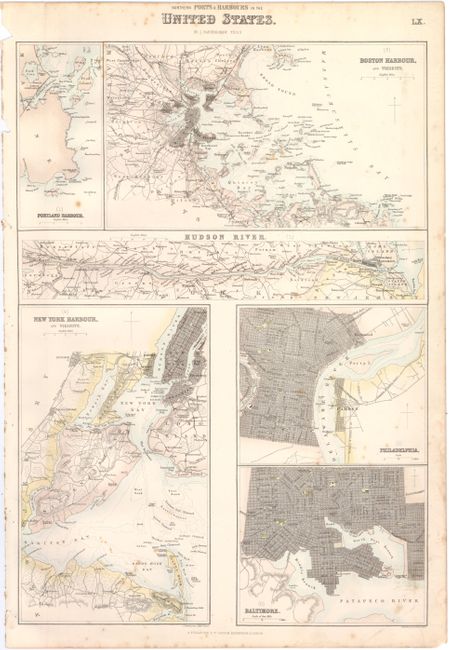
Auction 141, Lot 158
Subject: Eastern United States
Fullarton, Archibald & Co.
[Lot of 2] Northern Ports & Harbours in the United States [and] Southern Ports & Harbours in the United States, 1860
Size: 11.8 x 17 inches (30 x 43.2 cm)
Estimate: $130 - $160
Sold for: $80
Closed on 9/5/2012
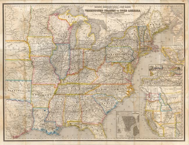
Auction 141, Lot 159
Subject: Eastern United States
Bromme, Traugott
Neueste Eisenbahn-Kanal-u. Post-Karte fur Reisende in den Vereinigten Staaten von Nord-Amerika Canada, Texas u. Californien…, 1863
Size: 29 x 21.5 inches (73.7 x 54.6 cm)
Estimate: $300 - $375
Sold for: $220
Closed on 9/5/2012
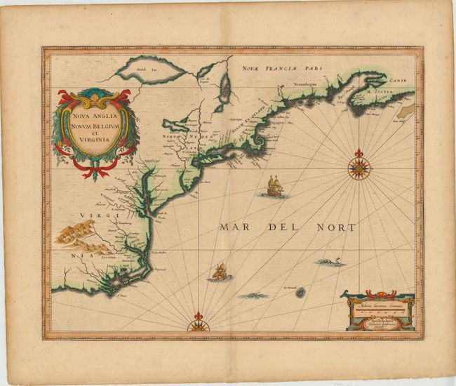
Auction 141, Lot 160
Subject: Colonial New England and Mid-Atlantic
Jansson, Jan
Nova Anglia Novum Belgium et Virginia, 1639-42
Size: 20 x 15.3 inches (50.8 x 38.9 cm)
Estimate: $2,000 - $2,300
Jansson's Influential Map of the East Coast
Unsold
Closed on 9/5/2012
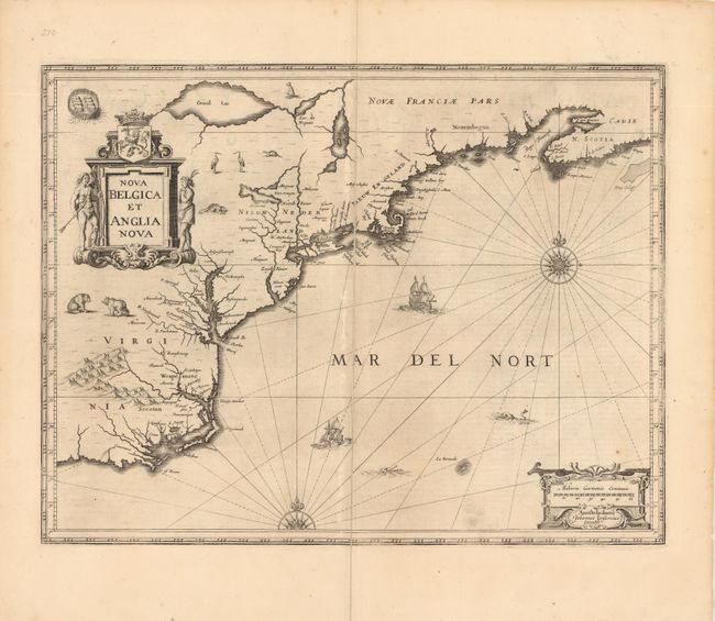
Auction 141, Lot 161
Subject: Colonial New England and Mid-Atlantic
Jansson, Jan
Nova Belgica et Anglia Nova, 1647
Size: 20 x 15 inches (50.8 x 38.1 cm)
Estimate: $1,800 - $2,100
Unsold
Closed on 9/5/2012
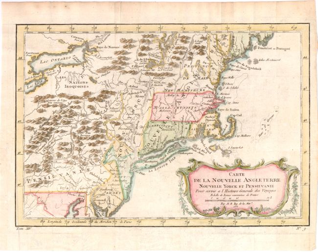
Auction 141, Lot 162
Subject: Colonial New England and Mid-Atlantic
Bellin, Jacques Nicolas
Carte de la Nouvelle Angleterre Nouvelle Yorck et Pensilvanie pour Servir a l'Histoire Generale des Voyages, 1757
Size: 11.8 x 8.1 inches (30 x 20.6 cm)
Estimate: $240 - $300
Sold for: $180
Closed on 9/5/2012
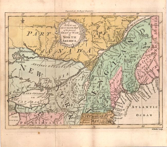
Auction 141, Lot 163
Subject: Colonial New England
A New and Accurate Map of the Present Seat of War in North America, 1759
Size: 14.8 x 11.3 inches (37.6 x 28.7 cm)
Estimate: $300 - $400
Sold for: $150
Closed on 9/5/2012
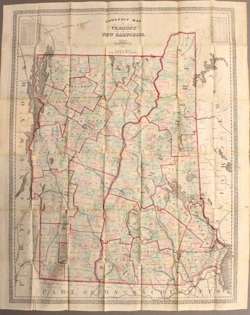
Auction 141, Lot 164
Subject: Vermont, New Hampshire
Dutton, E. P.
Township Map of Vermont and New Hampshire, 1868
Size: 22.5 x 29.5 inches (57.2 x 74.9 cm)
Estimate: $120 - $150
Sold for: $70
Closed on 9/5/2012
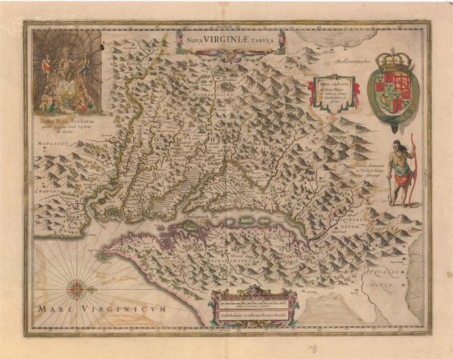
Auction 141, Lot 165
Subject: Colonial Mid-Atlantic
Hondius, Henricus
Nova Virginiae Tabula, 1647
Size: 19.5 x 15 inches (49.5 x 38.1 cm)
Estimate: $2,000 - $2,400
One of the Most Important 17th Century Maps of the Chesapeake Bay
Sold for: $1,500
Closed on 9/5/2012
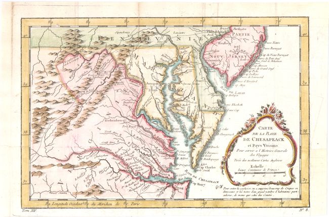
Auction 141, Lot 166
Subject: Colonial Mid-Atlantic
Bellin, Jacques Nicolas
Carte de la Baye de Chesapeack et Pays Voisins pour Servir a l'Histoire Generale des Voyages, 1757
Size: 11.5 x 7.5 inches (29.2 x 19.1 cm)
Estimate: $275 - $350
Sold for: $200
Closed on 9/5/2012
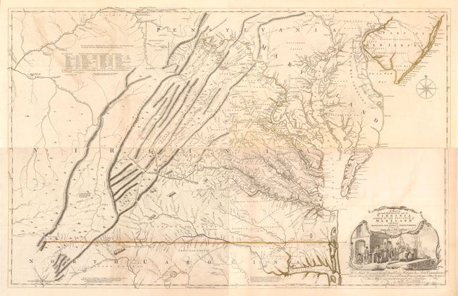
Auction 141, Lot 167
Subject: Colonial Virginia, Maryland
Fry, Joshua & Jefferson, Peter
A Map of the Most Inhabited Part of Virginia Containing the Whole Province of Maryland with Part of Pensilvania, New Jersey and North Carolina, 1775
Size: 48.5 x 31 inches (123.2 x 78.7 cm)
Estimate: $32,000 - $40,000
1775 Edition of the Landmark Fry-Jefferson Map of Virginia and Maryland
Sold for: $24,000
Closed on 9/5/2012
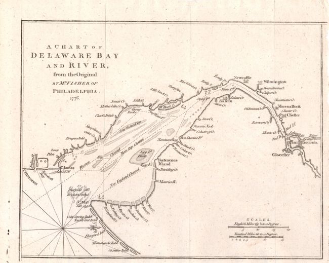
Auction 141, Lot 168
Subject: Colonial Mid-Atlantic
Anon.
A Chart of Delaware Bay and River, from the Original by Mr. Fisher of Philadelphia - 1776, 1779
Size: 9.2 x 7.2 inches (23.4 x 18.3 cm)
Estimate: $200 - $240
Unsold
Closed on 9/5/2012
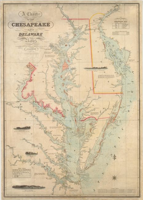
Auction 141, Lot 169
Subject: Mid-Atlantic United States, Chesapeake and Delaware Bays
Lucas, Fielding
A Chart of the Chesapeake and Delaware Bays, 1852
Size: 28.3 x 40 inches (71.9 x 101.6 cm)
Estimate: $8,000 - $10,000
Scarce Sea Chart of the Chesapeake and Delaware Bays
Unsold
Closed on 9/5/2012
Auction 141, Lot 170
Subject: Colonial Southeast
Mercator/Hondius
Virginia et Florida, 1609
Size: 7.2 x 5.8 inches (18.3 x 14.7 cm)
Estimate: $550 - $650
Sold for: $400
Closed on 9/5/2012
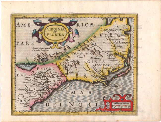
Auction 141, Lot 171
Subject: Colonial Southeast
Jansson, Jan
Virginiae Partis Australis, et Floridae Partis Orientalis, interjacentiumq Regionum Nova Descriptio, 1639
Size: 19.8 x 15.3 inches (50.3 x 38.9 cm)
Estimate: $1,600 - $1,800
Unsold
Closed on 9/5/2012
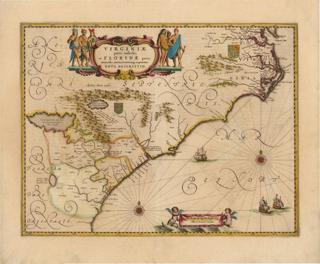
Auction 141, Lot 172
Subject: Colonial Southeast
Bellin, Jacques Nicolas
Carte de la Caroline et Georgie pour Servir a l'Histoire Generale des Voyages, 1757
Size: 11.3 x 7.4 inches (28.7 x 18.8 cm)
Estimate: $200 - $240
Sold for: $150
Closed on 9/5/2012
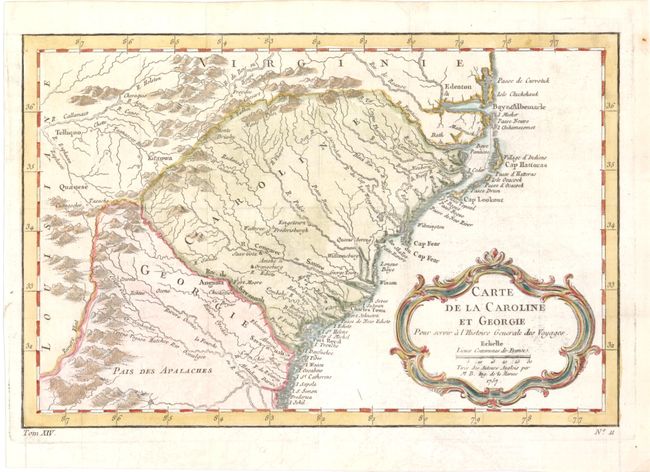
Auction 141, Lot 173
Subject: Colonial Southeast
Bonne, Rigobert
Carte de la Partie Sud des Etats Unis de l'Amerique Septentrionale, 1780
Size: 12.3 x 8.3 inches (31.2 x 21.1 cm)
Estimate: $160 - $200
Sold for: $80
Closed on 9/5/2012
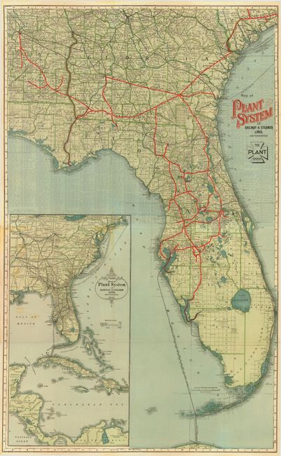
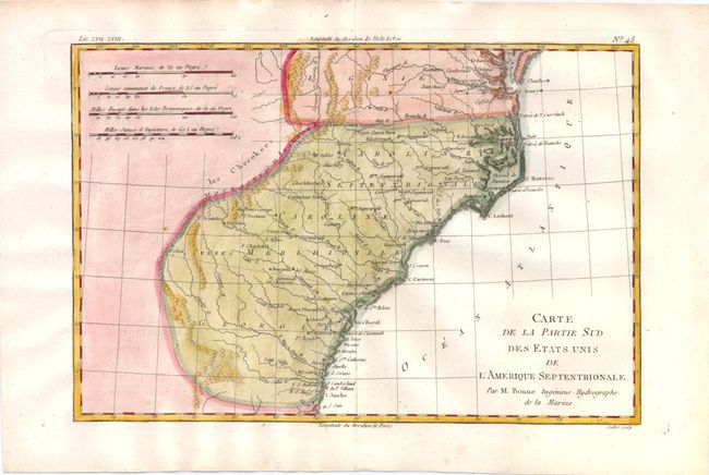
Auction 141, Lot 174
Subject: Southeastern United States, Florida
Railroad Companies, (Various)
Map of Plant System of Railway & Steamer Lines, and Connections, 1900
Size: 19 x 31.5 inches (48.3 x 80 cm)
Estimate: $325 - $400
Sold for: $250
Closed on 9/5/2012
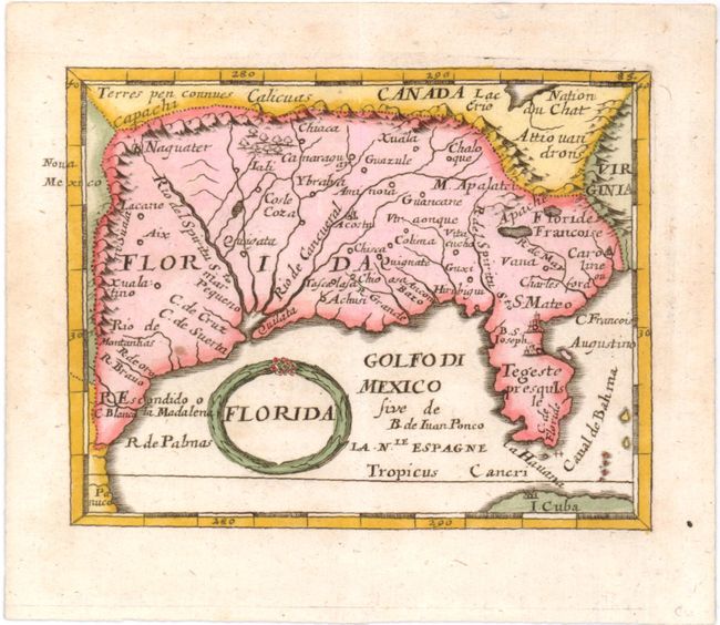
Auction 141, Lot 175
Subject: Colonial South
Duval/Beer
Florida, 1678
Size: 4.8 x 3.7 inches (12.2 x 9.4 cm)
Estimate: $350 - $425
Sold for: $275
Closed on 9/5/2012
164 lots
Page 1 of 4