Catalog Archive
Auction 141, Lot 146

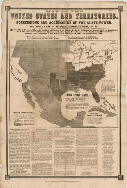
Fascinating and Rare Example of Political Propaganda and Thematic Mapping

"Map of the United States and Territories, Showing the Possessions and Aggressions of the Slave Power",

Subject: United States, Civil War

Period: 1856 (circa)

Publication:

Color: Black & White

Size:
26 x 42 inches
66 x 106.7 cm
Download High Resolution Image
(or just click on image to launch the Zoom viewer)

Issued during, or shortly after, the presidential election campaign of 1856, William Bloss’s map illustrates the slavery issue that would eventually lead to the outbreak of the Civil War. The dark shaded area in the South represents the slave holding states, the unshaded area in the North shows free states, and the large gray area illustrates the disputed territories. The Missouri Compromise Line prominently cuts through the western territories. This map, along with a similar Reynold’s Political Map of the United States were produced in support of the newly formed Republican party and its first Presidential nominee, John C. Fremont. Fremont was a staunch opponent of the westward expansion of slavery and the associated Kansas-Nebraska Act.

William Bloss was a social reformer and one of the founders of the anti-slavery movement. In 1843, he published the early Anti-Slavery paper The Rights of Man. In 1856, he provided the Massachusetts Emigrant Aid Company a Bible and grammar book for each settler in route to Kansas. Bloss’s convictions are clearly seen in the text surrounding the map, writing that "Sounds that address the Ear, are lost and die in one short hour; but that which strikes the Eye lives long upon the mind; the faithful Sight engraves the knowledge with a beam of light." His distribution channel for the map appears to be through the newly formed Republican clubs around Rochester with a note at right stating that "Clubs should purchase this at wholesale, and hang it on the wall of every sincere enquirer after the truth."

This is a very rare, newspaper-style political broadside with only three records found in university collections (per WorldCat) and is not in the Library of Congress. Engraved by George Frauenberger and published by A. Strong & Co.

Additional Information: There is an excellent article on this map and other similar political broadsides on Susan Schulten’s website, Mapping the Nation. Susan is Professor and Chair of the Department of History at Denver University, and recently gave a fascinating talk in late July at “The Mapping of North America: The Westward Expansion Conference.” The conference was hosted by the Rocky Mountain Map Society & the Texas Map Society in Denver, Colorado.

References: Sabin #5996.

Condition: C+

There are numerous splits at folds and fold intersections resulting in some minor loss. There is scattered foxing, a number of stains, and a small worm track below Louisiana in the phrase "United States Senate". Issued folding. Overall, still good condition for a broadside map that would benefit from simple conservation efforts.

Estimate: $2,000 - $4,000

Sold for: $4,750

Closed on 9/5/2012

Archived