The Mapmakers Who Made the 19th Centuryby Jon Dotson
We continue our series of notable mapmakers with a glimpse into the 19th century. While the process of mapmaking was essentially unchanged in the first three centuries of our series, the 19th century represented a period of great change both in terms of paper and printing technique. Early in the century, machine wove paper (as opposed to hand laid) became the standard with the invention of a machine that produced paper on a continuous roll. In the 1840s, as demand for paper outpaced supply, cheaper wood pulp would replace cotton rag. At the same time, expensive copper plates that were the staple at the turn of the century were replaced over time by cheaper methods of production including steel plates, lithography and cerography (wax engraving). The combined effect of these innovations meant lower barriers to entry and a marked increase in the number of participants in cartography (a term coined in the 19th century). Given the large pool of influential and prolific mapmakers in the 19th century, we decided to highlight a representative sample that we frequently encounter at Old World Auctions. (Here are quick links to our previous articles on mapmakers from the 16th century, 17th century and 18th century.)
United States Government
Over the course of the 19th century, the United States government was the most prolific map publisher in the world. Based upon the Old World Auctions archive of map records, greater than 1 in 8 maps from the 19th century were issued by a U.S. agency. The vast majority of these maps were provided as exhibits or appendices that accompanied reports to the U.S. Congress and usually appear issued folding on thin wood pulp paper. Some of the more frequent map issuers include the Government Printing Office, War Department, Coast Survey, Corps of Engineers, Bureau of Indian Affairs, State Surveys, and the Geological Survey. Generally speaking, the maps found in Congressional reports were utilitarian in nature, and illustrated the issues and growing pains of a new nation including boundary disputes, internal improvements, frontier defenses, and more. These maps revealed important secondary information as well such as roads, canals, railroads, place names, watersheds, and more. The maps were usually the best source of current information and frequently utilized by commercial cartographers for their own publications.
The nature of the maps found in these congressional reports shifted during the century with much of the first half focused on the reconnaissance of the western United States. Government-backed exploration from this early period include Lewis & Clark and Zebulon Pike. Later explorers whose maps appeared in congressional reports include John Fremont, James Kearney, and Gouverneur Warren, who produced the first map to accurately represent the entire trans-Mississippi west. During the 1850s, the U.S. government sponsored an extensive series of expeditions to gather information on the vast new territories that had been acquired in western North America. The discovery of gold in California further stimulated westward traffic and heightened the need for a faster and more convenient way to bring the far-flung parts of the country together. These reports, maps and lithographs were published in a mammoth thirteen-volume series entitled "Explorations and Surveys to ascertain the most practicable and economical route for a Railroad from the Mississippi river to the Pacific Ocean."
Maps of the latter half of the 19th century shifted away from exploration to the less glamorous (but absolutely necessary) work of surveying. The General Land Office (GLO) was responsible for implementing the Public Land Survey System, which subdivided the entire west into square mile blocks for purchase and sale. Other notable surveying work included the efforts of Clarence King, Ferdinand Hayden, John Wesley Powell, and George Wheeler to map the west. This led to the establishment of the U.S. Geological Survey in 1879, which was charged with the "classification of the public lands, and examination of the geological structure, mineral resources, and products of the national domain."
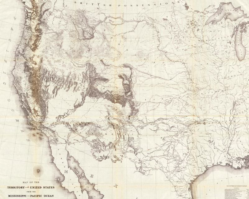
Map of the Territory of the United States from the Mississippi to the Pacific Ocean... (1857)
Known as "Warren's General Map," this monumentally important map is considered to be the first accurate overall picture of the region and culminated a half-century of government explorations. Only 24 years old when assigned the task, Warren used information from the U.S. Land Office, the Coast Survey, Topographical Engineers, the Adjutant General, the Quartermaster General, the Indian Bureau, and Smithsonian Institution to obtain the latest information in developing this map. (Image Courtesy of the David Rumsey Map Collection)
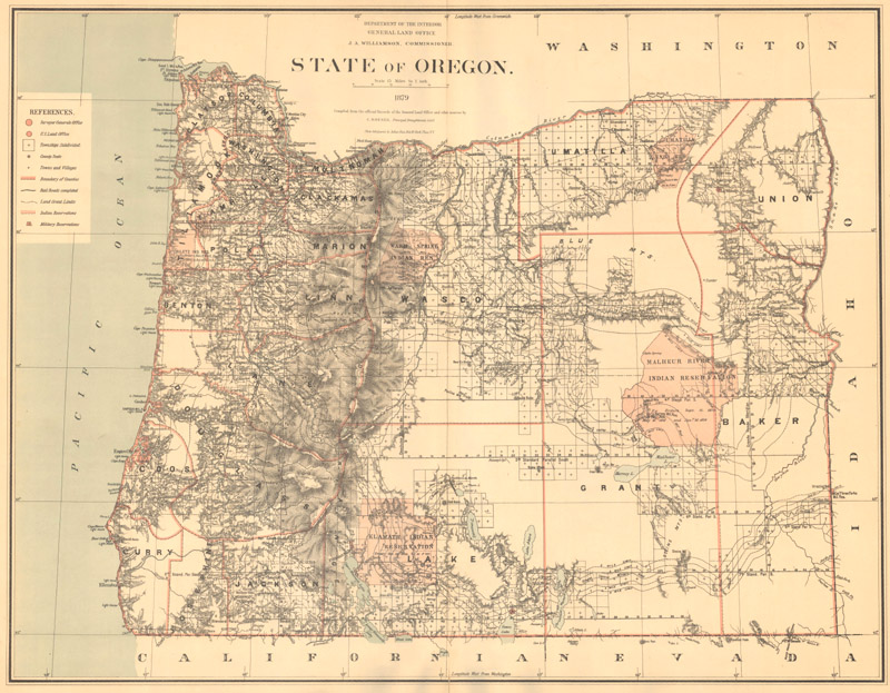
State of Oregon (1879)
This GLO map features excellent detail from the Cascade Mountains west to the Pacific coast and notes towns and villages, roads, railroads, and topography shown in bold hachure. Regions to the east of the Cascades have only been partially surveyed with large tracts of empty space. The legend identifies Indian reservations, military reservations, railroad limits, land grants, and townships subdivided.
Aaron Arrowsmith (1750-1823)
Aaron Arrowsmith was born in Durham, England on July 14th, 1750. Despite a rather humble upbringing with a limited education, he became one of the best cartographers of his generation. Arrowsmith largely taught himself the principles of cartography and moved to London around 1770 to begin his career. He apprenticed under the William Faden Jr. firm for a time, and later joined John Cary's firm as a land surveyor. His first signed work was a survey of the road from London to Falmouth in 1782, which was subsequently published by Cary in 1784.
In 1790, Arrowsmith decided to set out on his own, opening a shop at Castle Street. In that same year, he published his first wall map entitled Chart of the World on Mercator's Projection and quickly established himself as one of the most prominent mapmakers in London. Over the next 30 years, he would make large wall maps the firm's specialty, publishing important maps of North America, Asia, Africa, as well as several multi-sheet maps of the British Isles. His copper-engraved maps were superior to competitors for their synthesis of information, and reflect his incredible ability to gather up-to-date information from a wide variety of sources. It is important to note that Arrowsmith continuously updated his maps while the majority of his competition recycled outdated information. His map of North America has at least 11 recorded states, and his eastern United States map has 10.
Over his career, Arrowsmith is known to have published over 200 maps, mostly large scale, and "was easily the foremost cartographer of his time" (Tooley, p. 24) and "the most influential and respected map publisher of the first quarter of the nineteenth century" (Martin & Martin p. 113). His sphere of influence also crossed the Atlantic where he partnered with Samuel Lewis in 1802 to produce A New and Elegant General Atlas. Aaron Arrowsmith passed away in 1823, though the business continued to operate by his sons Aaron Sr. and Samuel, and his nephew John.
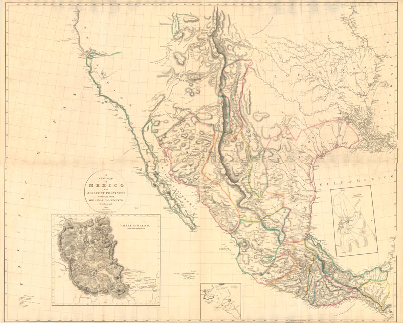
A New Map of Mexico and Adjacent Provinces... (1810)
This is one of the most important maps of Texas and the Southwest from the early 19th century. Arrowsmith's map was the first to incorporate the discoveries of both Zebulon Montgomery Pike (1810) and Alexander von Humboldt (1811). The California coastline was based on the explorations of Vancouver, whose track is noted in the map, as well as information provided by the Hudson's Bay Company. The Rocky Mountain region and the Gulf Coast draw primarily on Humboldt, while present-day Texas and the Brazos and Guadalupe River regions were based on Pike's accounts. This map is an excellent representation of Arrowsmith's ability to sift through conflicting data between explorers and incorporate the most accurate cartographical information to create the most up-to-date map of the region.
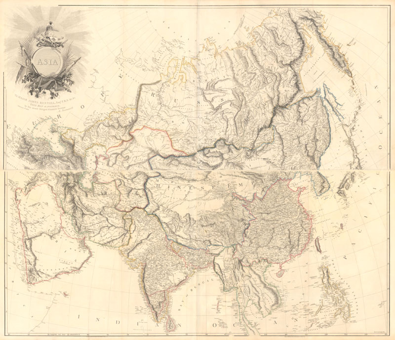
Asia (1801)
This incredibly detailed, large-format map covers all of Asia from the Ural Mountains and Black Sea to Japan and the Philippines. It is most remarkable for its superb topographical detail considering the remoteness of much of the region. In the Pacific, the routes of the Lion (Lord McCartney's Embassy to China) and the Astrolabe (La Perouse's circumnavigation) are shown off of eastern Asia. The map includes several notations along the Arctic Circle including "here some Dutch Vessels wintered in 1596" (Nova Zembla) and "A spot where a copper kettle was found and some cloven wood." Arrowsmith dedicated the map to James Rennell, who is now considered the "Father of Indian Cartography," and no doubt incorporated Rennell's surveys in the southern sections of this map.
John Tallis (1817-1876)
While little is known about the Tallis family, the maps produced by John Tallis and his father, John Tallis Sr., and are instantly recognizable and immensely popular among collectors. John Tallis Sr. first set up shop at 15 St. John's Lane in Smithfield (London) in 1835 and the duo's first major publication entitled London Street Views was issued in 1838. These detailed and accurate street plans were both popular and profitable, allowing the Tallis firm to publish other works during the 1840s including Thomas Dygdale's Curiosities of Great Britain and Thomas Wright's The Universal Pronouncing Dictionary.
When John Tallis Sr. died in 1842, John Tallis partnered with his brother Frederick, who recently became involved in the map business. In the late 1840s, the pair began publishing maps in subscription form to target a middle-class audience that led insular lives due to the expense and hardship of travel. These steel-engraved maps not only provided up-to-date geographical knowledge, but also used vignette views within the map's design to show the native people and their occupations, cities and points of interest. The maps hark back to a cartographic tradition from the Dutch mapmakers of the seventeenth century with finely engraved decorative borders. The maps were drawn and engraved by John Rapkin with views drawn and engraved by over 30 prominent artists, and would eventually become The Illustrated Atlas.
After several successful years of the subscription model, Tallis issued the complete volume of the Illustrated Atlas beginning in 1851. Both maps and vignettes were continuously updated based upon expanding geographic knowledge, including at least five different editions of the maps of Australia. While the atlas ceased publication in 1865, Tallis maps can be found in geographical dictionaries and encyclopedias until about 1880. Tallis' success showed in its footprint - the firm was one of the first publishers to have offices in both New York and London, with offices in four countries at the firm's height.
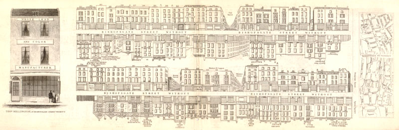
London Street View (ca. 1840)
A highly detailed plan depicting Bishopsgate Street Without including views of individual buildings, several named businesses, and a large illustration of Thomas Millington's manufacturing business at left. Tallis included advertisements within his publications to help offset production costs.
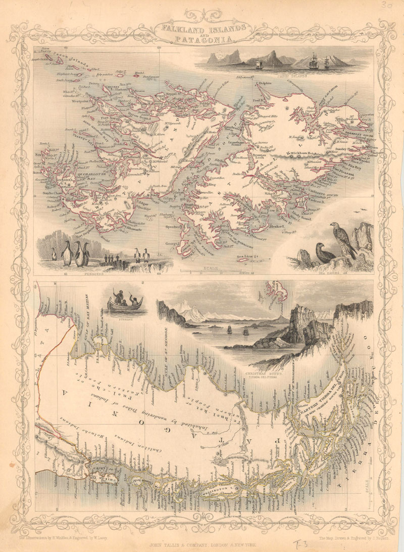
Falkland Islands and Patagonia (ca. 1850)
Two maps within one decorative border in Tallis' typical style. The map of the Falklands is surrounded by finely rendered engravings of penguins, sea birds, and tall ships anchored off Jason Island. The map of Patagonia has a large vignette of Christmas Sound in Tierra del Fuego with clippers under sail along with a small vignette of Fugeans in a boat.
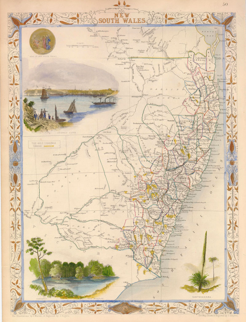
New South Wales (ca. 1852)
Attractive map of New South Wales with remarkable detail along the coastline. The map indicates the locations of the gold diggings, heralding the beginning of the Australian Gold Rush of 1851. It is surrounded by well-rendered vignettes of the Seal of New South Wales, Sydney Cove, The Murray, and an agave-type plant named Xanthorrhaea. The large vignette of Sydney presents a lovely view from the harbor.
Samuel Augustus Mitchell (1792-1868)
Samuel Augustus Mitchell was born in Bristol, Connecticut, in 1792. Originally a teacher, he found himself consistently disappointed by the quality of the geography textbooks. He moved to Philadelphia and entered map and atlas publishing in 1831 with A New American Atlas, a revised issue of Anthony Finley's atlas from the 1820s. Mitchell recruited J.H. Young, the engraver who worked for Finley, and entered a collaboration with him that spanned decades. Young would prove to be an essential collaborator, making up for Mitchell's lack of cartographic expertise by serving as his primary compiler, draftsman, and engraver. During the 1830s, Mitchell also published numerous travel guides of the eastern and central United States, intended for emigrants and tourists exploring new lands to the west.
In 1845, Mitchell bought the copyright for Tanner's A New Universal Atlas from Carey and Hart, and in the subsequent year his company published two editions of this milestone atlas. These editions of the atlas are early examples of the lithographic transfer process in American commercial cartography. Whereas the maps in earlier editions of the New Universal Atlas were engraved on copper plates, with visible plate marks on the sheets, Mitchell's editions are believed to have utilized lithographic stones, with no plate marks. Hand-colored green borders were also added to the maps. Borders such as these would prove to be popular in the atlases of the latter half of the 19th century (Cram, Rand McNally, and many others), serving as ornamentation on maps that were otherwise more practical and scientific than decorative. Mitchell published the New Universal Atlas intermittently until 1850, when he sold the rights to Thomas, Cowperthwait, and Co.
In 1860, Samuel Augustus Mitchell Jr. took the reins of his father's company and began publishing the New General Atlas, a replacement for the New Universal Atlas. New editions of the New General Atlas were issued yearly with Mitchell Jr. named as publisher until 1879; the atlas would continue to be published by a variety of publishers until 1893, when it was released by the A.R. Keller Company under the altered title of Mitchell's Family Atlas of the World. The elder Mitchell continued to work on wall maps and other projects until his death in 1868. When the company he created was at its peak, it employed 250 and sold more than four hundred thousand publications a year. Click here to read more about 19th-century American atlas publishers from our July 2016 newsletter.
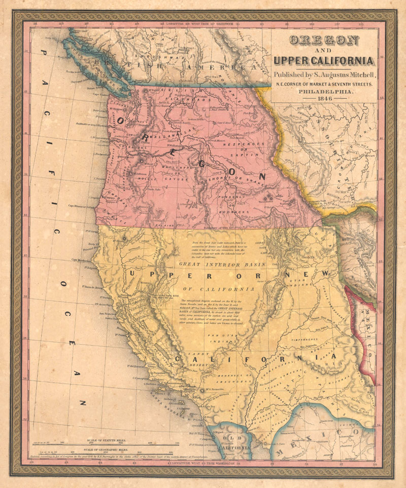
Oregon and Upper California (1846)
This great map is the first edition in this series of 14 significant maps depicting the rapidly changing American West. Oregon Territory is shown west of the Continental Divide with the northern Boundary of 1846 and the southern Boundary of 1819. Lewis and Clarke's route, Fremont's Route, and the Oregon Trail are noted through wilderness dotted with a few missions, forts, and numerous Indian tribes. The area labeled Upper or New California includes present-day California, Nevada, Utah, Arizona, and parts of New Mexico, Colorado, and Wyoming. The unexplored interior is labeled and described as the Great Interior Basin of California.
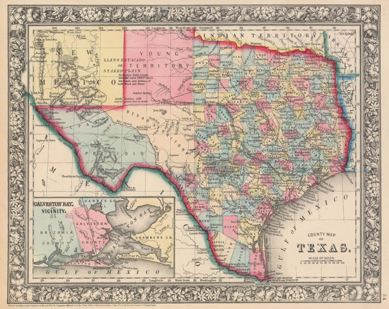
County Map of Texas (1860)
One of the most attractive maps of the state of Texas, inset with a map of Galveston Bay, and Vicinity. West Texas is made up of Young Territory, Bexar Territory, El Paso and Presidio counties, and clearly shows the Llano Estacado or Staked Plain with a notation about the region being "destitu[t]e of both wood and water." The map shows trails, roads, and a limited railroad system that extends only into Austin. The map is surrounded by a fine floral border.
The Transforming World
The 19th century brought great innovations to the world and to mapmaking primarily through manufacturing improvements in both source materials and process. As a result, maps were reasonably affordable and geographic knowledge was no longer limited to the wealthy. As the second Industrial Revolution faded in the early 20th century, a new wave of maps would emerge reflecting the chaos in the world order as a result of war. Stay tuned for our next newsletter focused on 20th century pictorial maps.
References:
Baynton-William, Ashley, “Aaron Arrowsmith Hydrographer to the King,” MapForum Issue 5, London, Spring 2005.
Koepp, Donna P. CIS US Serial Set Index and Carto-Bibliography of Maps, 1789-1897, Congressional Information Service, Inc., Bethesda, Maryland, 1995.
Manasek, F.J., Curt Griggs & Marti Griggs. Collecting Old Maps, Old Maps Press, Clarkdale, Arizona, 2015.
Martin, James C. & Robert Sidney. Maps of Texas and the Southwest, 1513-1900, Texas State Historical Association, Austin, Texas, 1999.
Martin, Montgomery. Antique Maps of the 19th Century World, Portland House, New York, New York, 1989.
Tooley, Ronald Vere. Tooley's Dictionary of Mapmakers, Alan R. Liss, Inc. and Meridian Publishing Company, New York, New York & Amsterdam, The Netherlands, 1979.
Worms, Laurence, “John Rapkin and Others: The Makers of the Tallis Maps,” MapForum Issue 11, London, 2007.