Showing Featured Lots(remove filter)
Showing results for:Auction 191
Catalog Archive
62 lots
Page 1 of 2
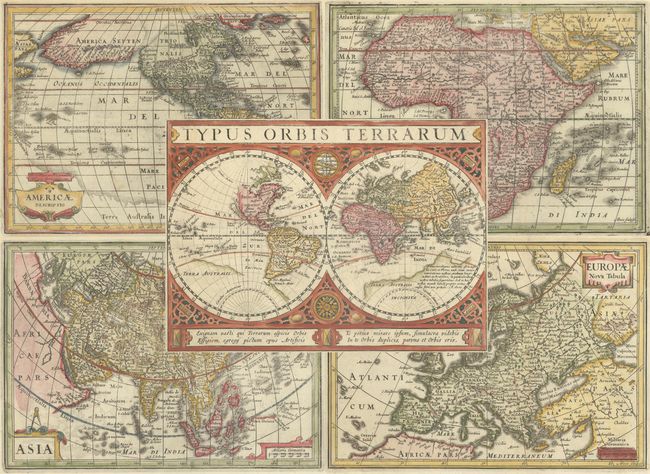
Auction 191, Lot 1
Subject: World & Continents
Cluver/Jansson
[Lot of 5] Typus Orbis Terrarum [and] Americae Descriptio [and] Africae Descriptio [and] Asia [and] Europae Nova Tabula, 1661
Size: 8 x 5.8 inches (20.3 x 14.7 cm)
Estimate: $2,200 - $2,500
Sold for: $1,600
Closed on 2/8/2023
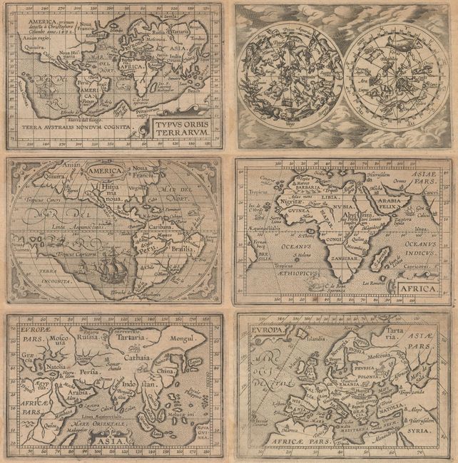
Auction 191, Lot 2
Subject: World & Continents
Ortelius/Coignet
[Lot of 6] Typus Orbis Terrarum [and] America [and] Africa [and] Asia [and] Europa [and] Globus Coelestis, 1609
Size: 4.8 x 3.3 inches (12.2 x 8.4 cm)
Estimate: $1,400 - $1,700
Matching Set from Miniature Ortelius Atlas
Sold for: $900
Closed on 2/8/2023
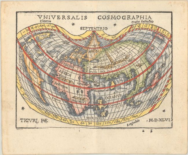
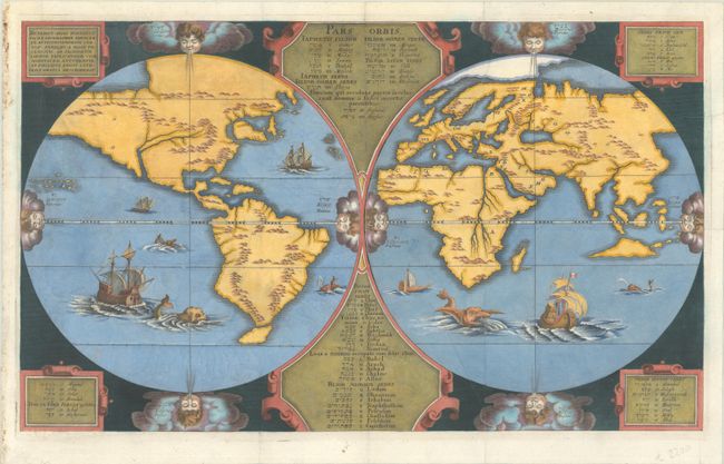
Auction 191, Lot 4
Subject: World
Honter, Jon Coronensis
Universalis Cosmographia, 1546
Size: 6.4 x 4.8 inches (16.3 x 12.2 cm)
Estimate: $1,400 - $1,700
Honter's Heart-Shaped Map of the World
Sold for: $1,600
Closed on 2/8/2023
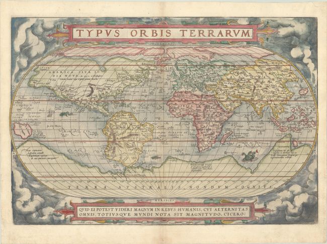
Auction 191, Lot 5
Subject: World
Ortelius, Abraham
Typus Orbis Terrarum, 1572
Size: 19.8 x 13.4 inches (50.3 x 34 cm)
Estimate: $7,000 - $8,500
Ortelius' Famous World Map - First Plate
Sold for: $7,500
Closed on 2/8/2023
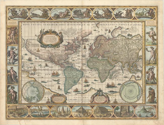
Auction 191, Lot 7
Subject: World
Blaeu, Willem
Nova Totius Terrarum Orbis Geographica ac Hydrographica Tabula, 1634
Size: 21.4 x 16 inches (54.4 x 40.6 cm)
Estimate: $12,000 - $15,000
Blaeu's Magnificent Carte-a-Figures World Map
Sold for: $9,000
Closed on 2/8/2023
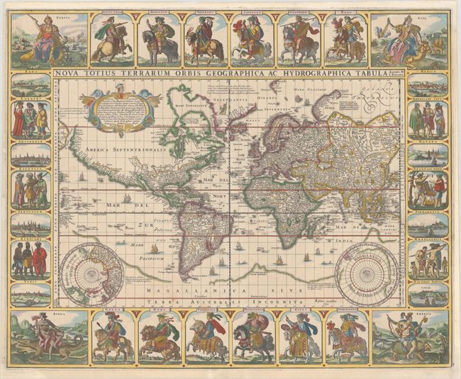
Auction 191, Lot 8
Subject: World
Visscher, Claes Janszoon
Nova Totius Terrarum Orbis Geographica ac Hydrographica Tabula Auctore N. I. Piscator, 1652
Size: 22.1 x 17.8 inches (56.1 x 45.2 cm)
Estimate: $14,000 - $16,000
Visscher's Rare Carte-a-Figures World Map
Sold for: $9,500
Closed on 2/8/2023
Auction 191, Lot 10
Subject: World
Arias Montanus, Benito
Benedict Arias Montanus Sacrae Geographiae Tabulam ex Antiquissimorum Cultop. Familiis a Mose Pecensitis…, 1660
Size: 20.4 x 12.3 inches (51.8 x 31.2 cm)
Estimate: $3,000 - $3,750
Scarce Map Showing How Noah's Sons Repopulated the World
Sold for: $1,500
Closed on 2/8/2023
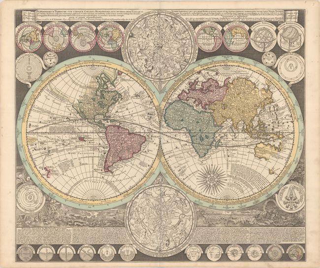
Auction 191, Lot 14
Subject: World
Zurner/Schenk
Planisphaerium Terrestre cum Utroque Coelesti Hemisphaerio, sive Diversa Orbis Terraquei... / Vlakke Aard-Kloot met het Beide Hemelsch Half-Rond, of de Onderscheidene Verbeelding van de Land-Water-Waereld…, 1700
Size: 22.9 x 19.9 inches (58.2 x 50.5 cm)
Estimate: $3,750 - $4,500
World Map with Astronomical Diagrams and Illustrations of Natural Phenomena
Sold for: $2,750
Closed on 2/8/2023
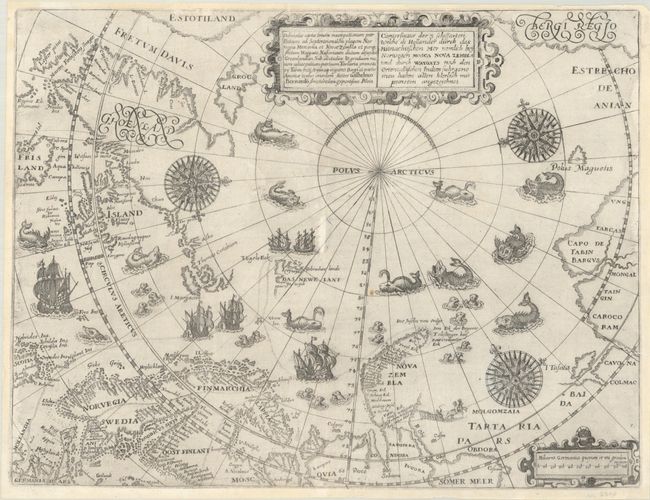
Auction 191, Lot 45
Subject: North Pole
Bry, Theodore de
Deliniatio Cartae Trium Navigationum per Batavos ad Septentrionalem Plagem Norvegia Moscovia et Nova Zembla... / Conterfactur der 3 Schiffarten Welche di Hollander durch das Mitnachtischen Mer Nemlich bey Norwegen Mosca Nova Zembla..., 1601
Size: 14.3 x 11 inches (36.3 x 27.9 cm)
Estimate: $3,500 - $4,250
Early Map of North Pole Depicting Barentsz' Expedition
Sold for: $4,000
Closed on 2/8/2023
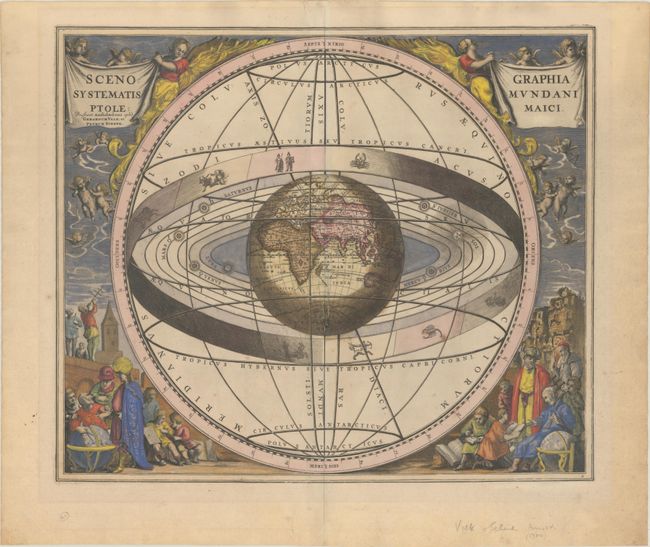
Auction 191, Lot 54
Subject: Solar System
Cellarius/Schenk & Valck
Scenographia Systematis Mundani Ptolemaici, 1708
Size: 19.8 x 16.8 inches (50.3 x 42.7 cm)
Estimate: $2,000 - $2,300
Cellarius' Striking Chart of the Ptolemaic Cosmography
Unsold
Closed on 2/8/2023
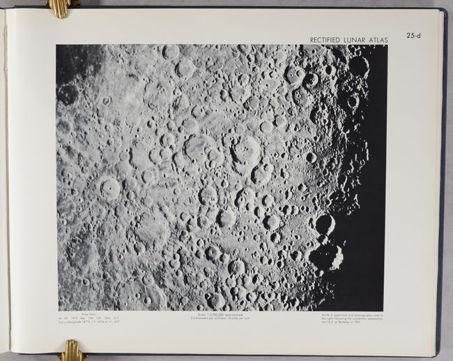
Auction 191, Lot 59
Subject: Moon
U.S. Air Force
Rectified Lunar Atlas - Supplement Number Two to the USAF Lunar Atlas, 1963
Size: 19 x 15.3 inches (48.3 x 38.9 cm)
Estimate: $750 - $900
Important Milestone in Preparation for 1969 Moon Landing
Sold for: $550
Closed on 2/8/2023
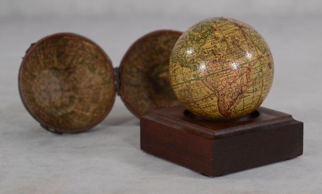
Auction 191, Lot 60
Subject: Globes
Anon.
A Correct Globe with the New Discoveries, 1785
Size: 3 x 3 inches (7.6 x 7.6 cm)
Estimate: $3,500 - $4,500
Miniature Pocket Globe Based on Herman Moll
Sold for: $3,750
Closed on 2/8/2023
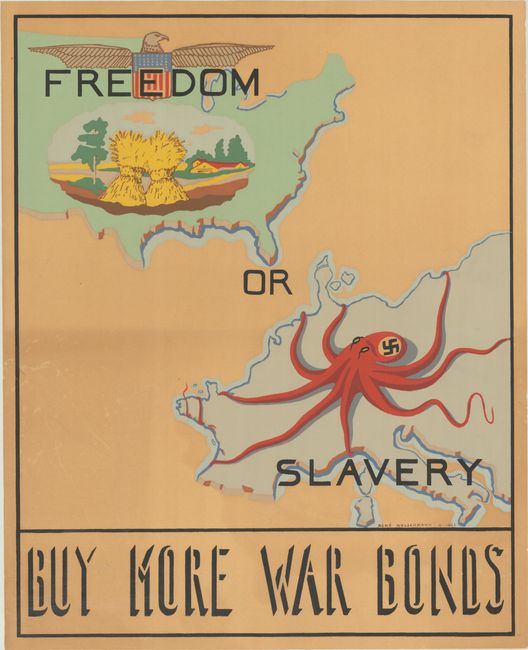
Auction 191, Lot 65
Subject: Cartographic Miscellany, World War II
Freedom or Slavery - Buy More War Bonds, 1943
Size: 14.8 x 18.3 inches (37.6 x 46.5 cm)
Estimate: $900 - $1,200
Rare WWII Propaganda Map Made by a Jewish Refugee and Former Prisoner-of-War
Sold for: $650
Closed on 2/8/2023
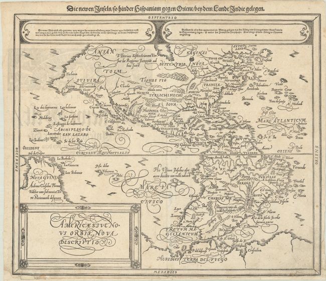
Auction 191, Lot 73
Subject: Western Hemisphere - America
Munster/Petri
Americae sive Novi Orbis, Nova Descriptio, 1614
Size: 14.3 x 12.2 inches (36.3 x 31 cm)
Estimate: $1,400 - $1,700
Munster's Take on Ortelius' Classic Map
Sold for: $1,000
Closed on 2/8/2023
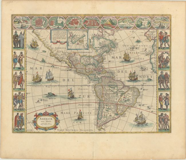
Auction 191, Lot 74
Subject: Western Hemisphere - America
Blaeu, Willem
Americae Nova Tabula, 1642
Size: 21.5 x 16.1 inches (54.6 x 40.9 cm)
Estimate: $5,000 - $6,500
Blaeu's Stunning Carte-a-Figures Map of the Americas in Full Contemporary Color
Sold for: $3,750
Closed on 2/8/2023
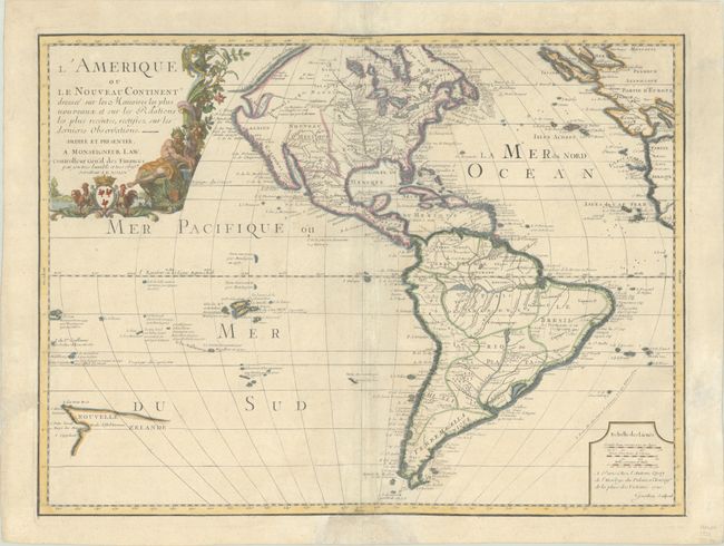
Auction 191, Lot 76
Subject: Western Hemisphere - America
Nolin, Jean Batiste
L'Amerique ou le Nouveau Continent Dressee sur les Memoires les Plus Nouveaux et sur les Relations les Plus Recentes, Rectifiez sur les Dernieres Observations, 1720
Size: 23.5 x 17.5 inches (59.7 x 44.5 cm)
Estimate: $1,400 - $1,700
Scarce Edition of Nolin's Map of the Americas
Sold for: $1,000
Closed on 2/8/2023
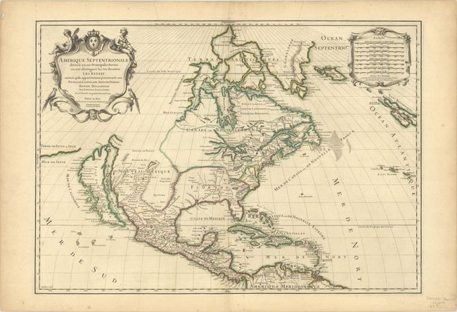
Auction 191, Lot 95
Subject: Colonial North America
Sanson/Jaillot
Amerique Septentrionale Divisee en ses Principales Parties, ou sont Distingues les uns des Autres les Estats..., 1698
Size: 25.4 x 18 inches (64.5 x 45.7 cm)
Estimate: $1,900 - $2,200
A Superb Map Showing the Island of California
Sold for: $1,400
Closed on 2/8/2023
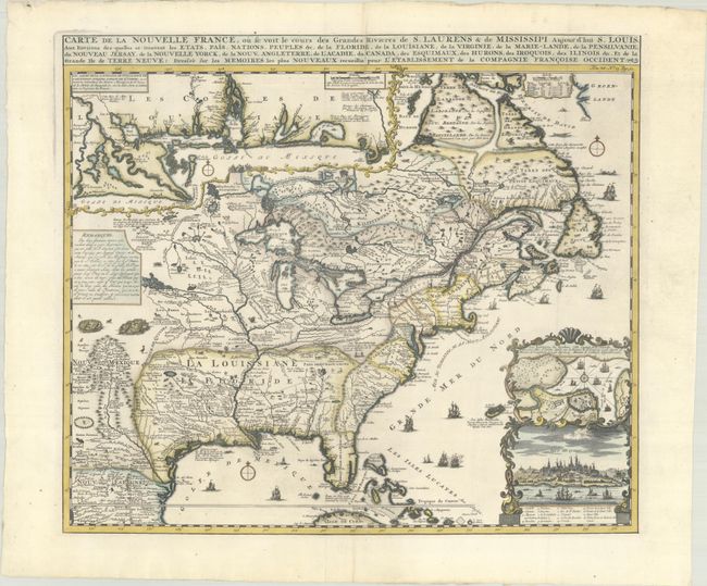
Auction 191, Lot 128
Subject: Colonial Eastern United States & Canada
Chatelain, Henry Abraham
Carte de la Nouvelle France, ou se Voit le Cours des Grandes Rivieres de S. Laurens & de Mississipi Aujour d'hui S. Louis, aux Environs des-quelles se Trouvent les Etats, Pais, Nations, Peuples &c. de la Floride..., 1720
Size: 19.1 x 16.6 inches (48.5 x 42.2 cm)
Estimate: $3,000 - $3,750
One of the Most Informative 18th Century Maps of the French Possessions in North America
Sold for: $3,000
Closed on 2/8/2023
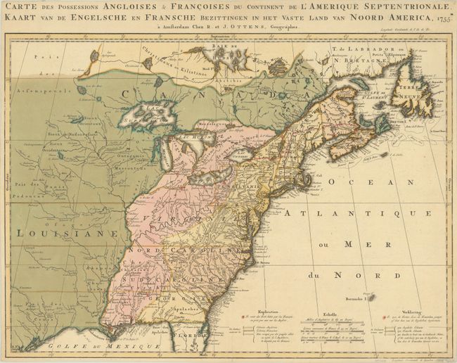
Auction 191, Lot 129
Subject: Colonial Eastern United States & Canada
Ottens, Reiner and Joshua
Carte des Possessions Angloises & Francoises du Continent de l'Amerique Septentrionale / Kaart van de Engelsche en Fransche Bezittingen in het Vaste Land van Noord America, 1755
Size: 22.4 x 16.3 inches (56.9 x 41.4 cm)
Estimate: $1,400 - $1,700
Dutch Version of an Important Map Showing Territorial Claims at the Outset of the French and Indian War
Sold for: $1,000
Closed on 2/8/2023
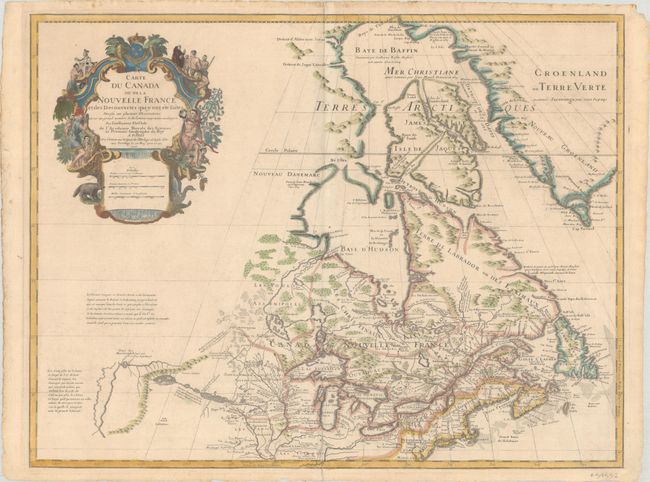
Auction 191, Lot 134
Subject: Colonial Northeastern United States & Canada, Great Lakes
Delisle, Guillaume
Carte du Canada ou de la Nouvelle France et des Decouvertes qui y ont ete Faites Dressee sur Plusieurs Observations et sur un Grand Nombre de Relations Imprimees ou Manuscrites..., 1703
Size: 25.6 x 19.6 inches (65 x 49.8 cm)
Estimate: $1,900 - $2,200
Delisle's Seminal Map of Canada and the Great Lakes
Sold for: $1,400
Closed on 2/8/2023
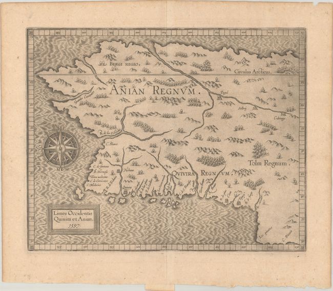
Auction 191, Lot 141
Subject: Alaska & Western Canada
Wytfliet, Cornelis
Limes Occidentis Quivira et Anian, 1597
Size: 11.5 x 9.3 inches (29.2 x 23.6 cm)
Estimate: $1,900 - $2,200
Early and Imaginary Map of Alaska and the Northwest Passage
Sold for: $1,400
Closed on 2/8/2023
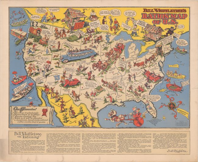
Auction 191, Lot 158
Subject: United States, World War II
[Lot of 2] Bill Whiffletree's Ration Map of U.S. [and] Bill Whiffletree's Bootleggers' Map of the United States, 1944
Size: 30.1 x 20.2 inches (76.5 x 51.3 cm)
Estimate: $3,000 - $4,000
Matching Pair Featuring the Extremely Rare "Ration Map"
Sold for: $2,000
Closed on 2/8/2023
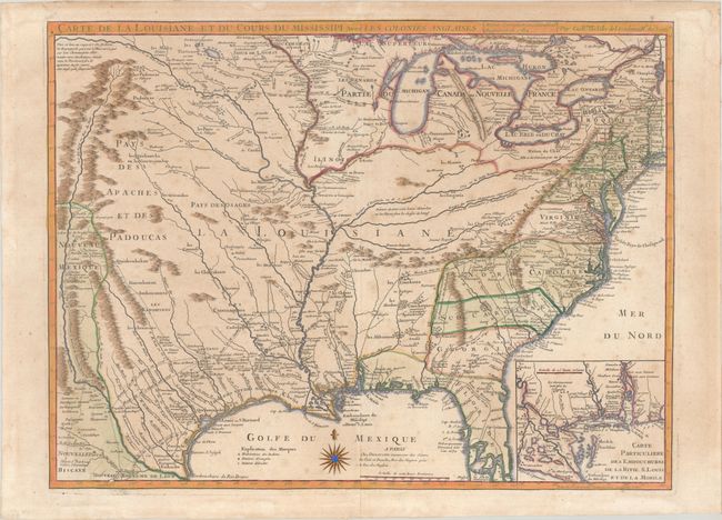
Auction 191, Lot 163
Subject: Colonial Eastern United States, Louisiana Territory
Delisle/Dezauche
Carte de la Louisiane et du Cours du Mississipi avec les Colonies Anglaises, 1782
Size: 25.5 x 19.2 inches (64.8 x 48.8 cm)
Estimate: $1,200 - $1,500
Dezauche Edition of Delisle's Influential Map of the Louisiana Territory
Sold for: $1,200
Closed on 2/8/2023
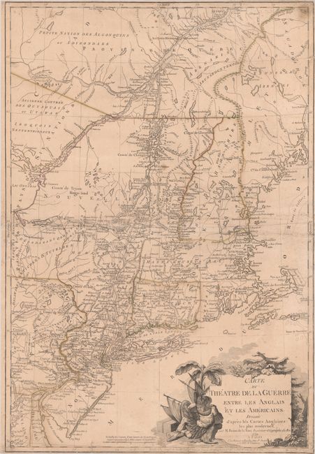
Auction 191, Lot 182
Subject: Colonial New England United States
Brion de la Tour, Louis
Carte du Theatre de la Guerre Entre les Anglais et les Americains: Dressee d'Apres les Cartes Anglaises les Plus Modernes, 1779
Size: 20.4 x 29.7 inches (51.8 x 75.4 cm)
Estimate: $4,000 - $5,000
Important Map Depicting Tipping Point of Revolutionary War
Unsold
Closed on 2/8/2023
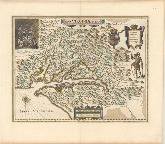
Auction 191, Lot 184
Subject: Colonial Mid-Atlantic United States
Hondius/Blaeu
Nova Virginiae Tabula, 1630
Size: 18.8 x 14.8 inches (47.8 x 37.6 cm)
Estimate: $2,000 - $2,300
One of the Most Important 17th Century Maps of the Chesapeake Bay
Sold for: $2,000
Closed on 2/8/2023
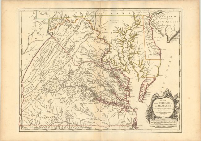
Auction 191, Lot 185
Subject: Colonial Mid-Atlantic United States
Robert de Vaugondy, Didier
Carte de la Virginie et du Maryland Dressee sur la Grande Carte Angloise de Mrs. Josue Fry et Pierre Jefferson..., 1755
Size: 25.2 x 19.1 inches (64 x 48.5 cm)
Estimate: $2,300 - $2,750
First State of Robert de Vaugondy's Essential Map of Virginia and Maryland
Sold for: $3,000
Closed on 2/8/2023
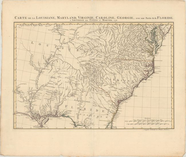
Auction 191, Lot 191
Subject: Colonial Southeastern United States
Covens & Mortier
Carte de la Louisiane, Maryland, Virginie, Caroline, Georgie, avec une Partie de la Floride, 1758
Size: 23.3 x 15.4 inches (59.2 x 39.1 cm)
Estimate: $1,100 - $1,400
Covens & Mortier's Map of the Southeast Issued During the French and Indian War
Sold for: $1,500
Closed on 2/8/2023
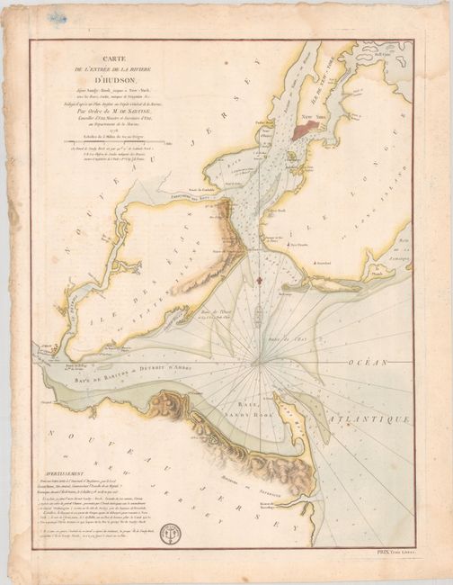
Auction 191, Lot 306
Subject: Colonial New York Harbor, Revolutionary War
Sartine
Carte de l'Entree de la Riviere d'Hudson, Depuis Sandy-Hook Jusques a New-York, avec les Bancs, Sondes, Marques de Navigation &c..., 1778
Size: 17.5 x 23.2 inches (44.5 x 58.9 cm)
Estimate: $1,600 - $1,900
Revolutionary War-Era Chart of New York Harbor Produced by the French Navy
Sold for: $1,200
Closed on 2/8/2023
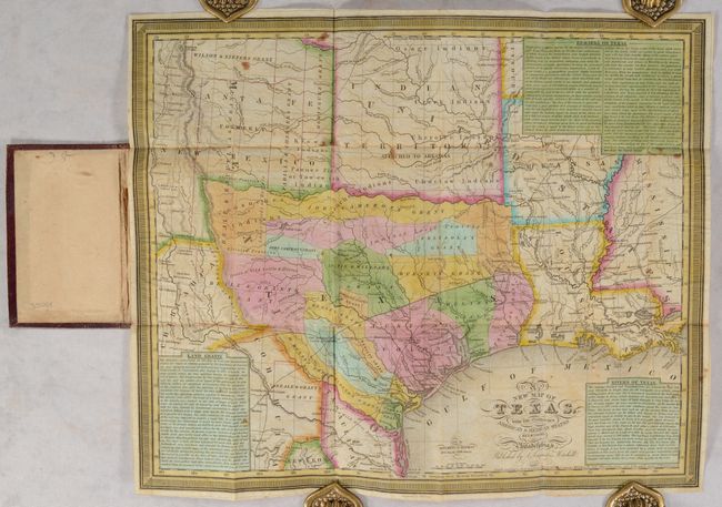
Auction 191, Lot 325
Subject: Texas
Mitchell, Samuel Augustus
A New Map of Texas, with the Contiguous American & Mexican States, 1837
Size: 15 x 12.4 inches (38.1 x 31.5 cm)
Estimate: $11,000 - $14,000
An Early and Important Map of the Republic of Texas
Sold for: $13,000
Closed on 2/8/2023
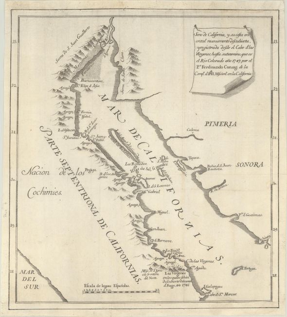
Auction 191, Lot 362
Subject: Gulf of California
Venegas, Miguel (Padre)
Seno de California, y su Costa Oriental Nuevamente Descubierta, y Registrada Desde el Cabo et las Virgenes..., 1747
Size: 11.4 x 12.5 inches (29 x 31.8 cm)
Estimate: $1,200 - $1,500
The Map That Put an End to the Island of California Myth
Sold for: $650
Closed on 2/8/2023
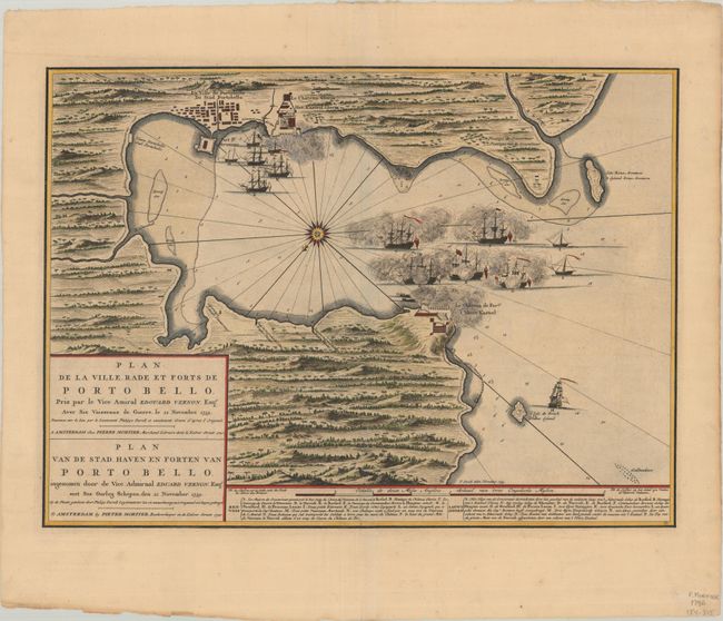
Auction 191, Lot 368
Subject: Portobelo, Panama
Mortier, Pierre
Plan de la Ville Rade et Forts de Porto Bello... / Plan van de Stad Haven en Forten van Porto Bello..., 1740
Size: 22.4 x 16.3 inches (56.9 x 41.4 cm)
Estimate: $1,600 - $1,900
Rare Chart of the Battle of Portobello
Sold for: $900
Closed on 2/8/2023
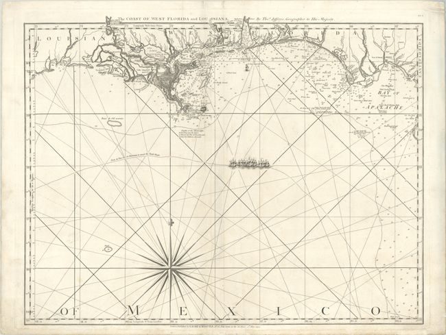
Auction 191, Lot 375
Subject: Gulf of Mexico
Jefferys/Laurie & Whittle
The Coast of West Florida and Louisiana, 1794
Size: 24.8 x 19.3 inches (63 x 49 cm)
Estimate: $1,400 - $1,700
Important 18th Century Map of Gulf Coast
Unsold
Closed on 2/8/2023
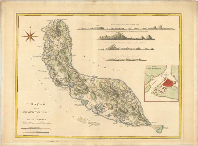
Auction 191, Lot 401
Subject: Curacao
Jefferys/Sayer
Curacao, from the Dutch Originals, of Gerald Van Keulen, Regulated by Astronomical Observations, 1775
Size: 24.3 x 18.4 inches (61.7 x 46.7 cm)
Estimate: $1,900 - $2,200
Sold for: $1,400
Closed on 2/8/2023
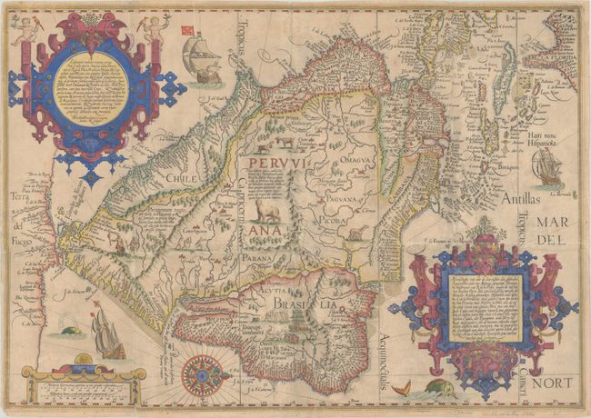
Auction 191, Lot 403
Subject: South America & Caribbean
Linschoten/Langren
Delineatio Omnium Orarum Totius Australis Partis Americae, Dictae Peruvianae, a R. de la Plata, Brasiliam, Pariam, & Castellam Auream..., 1596
Size: 22 x 15.4 inches (55.9 x 39.1 cm)
Estimate: $5,500 - $7,000
One of the Most Decorative Early Maps of South America
Sold for: $4,000
Closed on 2/8/2023
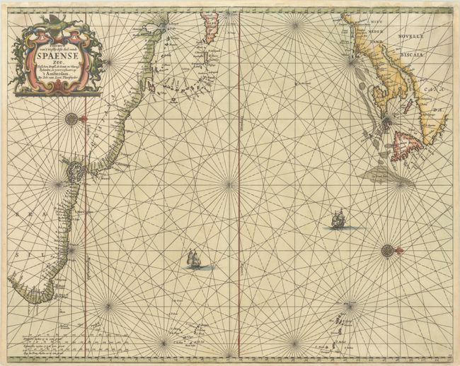
Auction 191, Lot 442
Subject: North Atlantic
Loon, Jan van
Pascaerte van 't Westlyckste deel vande Spaense Zee, Tusschen Brasil, de Zoute en Vlaemse Eylanden, en Voortwestwart Op, 1661
Size: 21.2 x 17.1 inches (53.8 x 43.4 cm)
Estimate: $700 - $850
Scarce Chart of the North Atlantic Depicting the New England Coastline
Sold for: $600
Closed on 2/8/2023
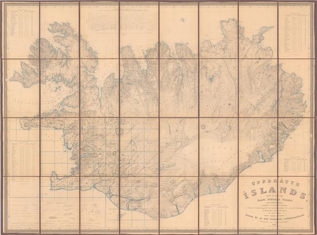
Auction 191, Lot 448
Subject: Iceland
Uppdrattr Islands..., 1844
Size: 44.8 x 33.4 inches (113.8 x 84.8 cm)
Estimate: $1,600 - $1,900
First Edition of the First Accurate Topographical Map of Iceland
Sold for: $1,700
Closed on 2/8/2023
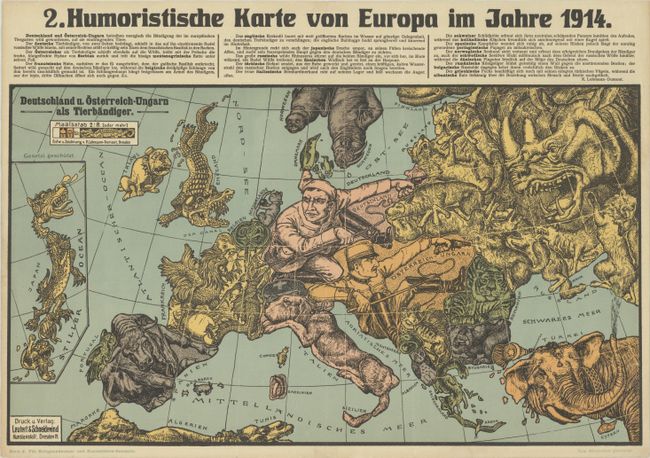
Auction 191, Lot 457
Subject: Europe, World War I
Leutert & Schneiderwind
[Lot of 3] Humoristische Karte von Europa im Jahre 1914 [and] 2. Humoristische Karte von Europa im Jahre 1914 [and] Humorist. Darstellung der Wappen underer Feinde 1914, 1914
Size: 19.2 x 10.9 inches (48.8 x 27.7 cm)
Estimate: $2,000 - $2,400
Extremely Rare Matching Set of Pro-German Propaganda From WWI
Sold for: $1,500
Closed on 2/8/2023
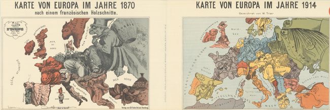
Auction 191, Lot 458
Subject: Europe, World War I
Karte von Europa im Jahre 1870 nach einem Franzosischen Holzschnitte / Karte von Europa im Jahre 1914, 1915
Size: 36.5 x 14 inches (92.7 x 35.6 cm)
Estimate: $900 - $1,100
Superb Pair of Satirical Maps Showing Political Changes in Europe from 1870-1914
Sold for: $650
Closed on 2/8/2023
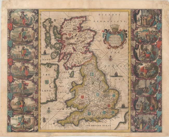
Auction 191, Lot 460
Subject: Britain
Jansson, Jan
Britannia Prout Divisa Suit Temporibus Anglo-Saxonum, Praesertim Durante Illorum Heptarchia, 1646
Size: 20.6 x 16.6 inches (52.3 x 42.2 cm)
Estimate: $1,200 - $1,500
Jansson's Splendid Heptarchy Map in Full Contemporary Color
Sold for: $850
Closed on 2/8/2023
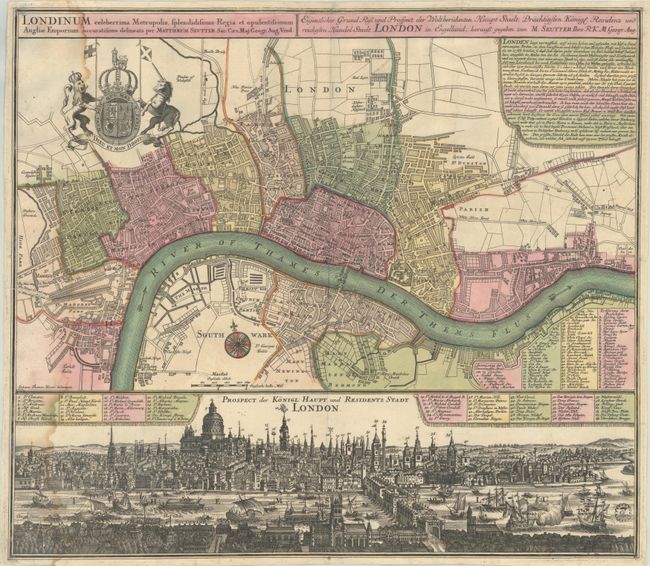
Auction 191, Lot 471
Subject: London, England
Seutter, Matthias
Londinum Celeberrima Metropolis, Splendidissima Regia et Opulentissimum Angliae Emporium... / Eigentlicher Grund Riss und Prospect der Weltberuhmten Haupt Stadt, Prachtigsten Konigl. Residenz und Reichesten Handel Stadt London in Engelland..., 1720
Size: 22.8 x 19.8 inches (57.9 x 50.3 cm)
Estimate: $2,200 - $2,500
A Superb Plan of London in Contemporary Color
Sold for: $1,600
Closed on 2/8/2023
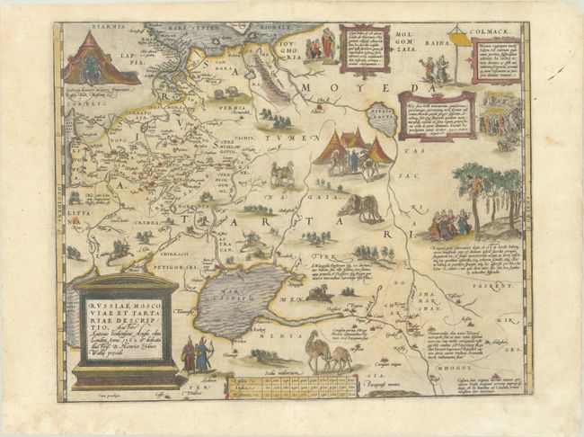
Auction 191, Lot 583
Subject: Russia, Eastern Europe & Central Asia
Ortelius, Abraham
Russiae, Moscoviae et Tartariae Descriptio. Auctore Antonio Ienkensono Anglo..., 1570
Size: 17.6 x 13.8 inches (44.7 x 35.1 cm)
Estimate: $2,000 - $2,300
Ortelius' Map of Russia with a Vignette of Ivan the Terrible
Sold for: $1,200
Closed on 2/8/2023
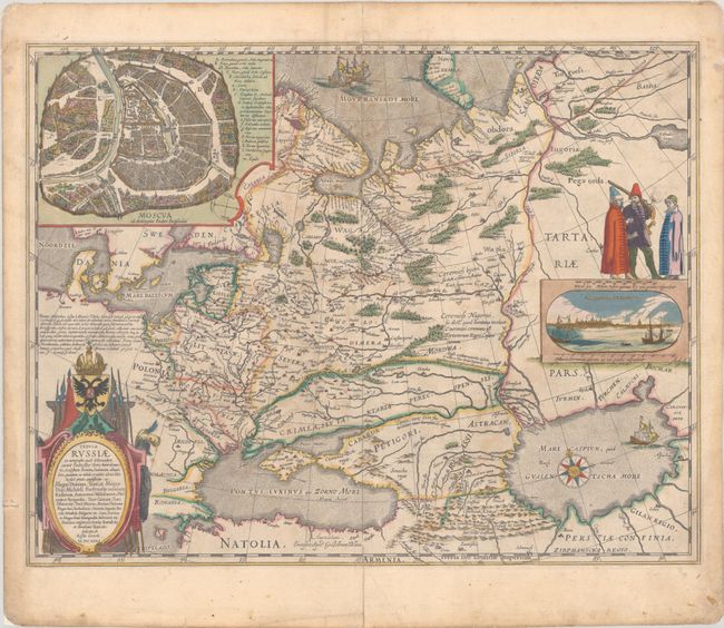
Auction 191, Lot 584
Subject: Russia in Europe
Blaeu, Willem
Tabula Russiae ex Autographo, quod Delineandum Curavit Foedor Filius Tzaris Boris Desumta ... M.DC.XIIII, 1643
Size: 21.7 x 16.8 inches (55.1 x 42.7 cm)
Estimate: $1,600 - $1,900
Blaeu's Decorative Map of Russia
Sold for: $1,000
Closed on 2/8/2023
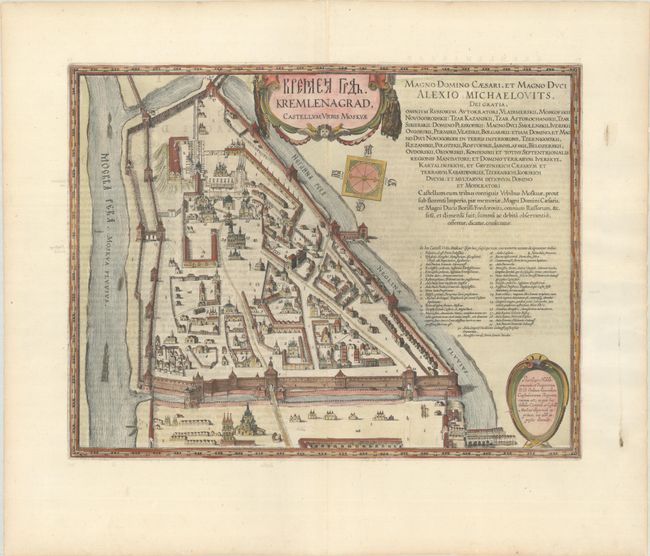
Auction 191, Lot 587
Subject: Moscow, Russia
Blaeu, Johannes
Kremlenagrad, Castellum Urbis Moskvae, 1662
Size: 19.2 x 14.8 inches (48.8 x 37.6 cm)
Estimate: $2,400 - $3,000
Superb Plan of the Walled Fortress of the Kremlin
Unsold
Closed on 2/8/2023
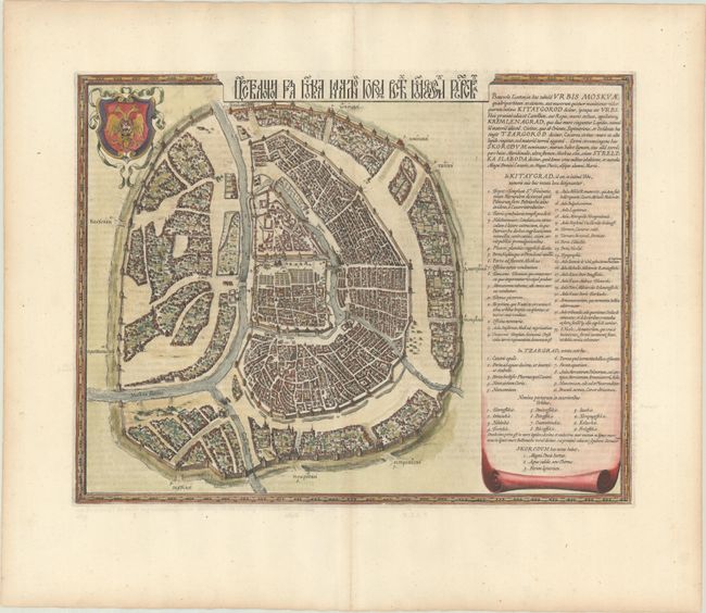
Auction 191, Lot 588
Subject: Moscow, Russia
Blaeu, Johannes
[Benevole Lector, in hac Tabula Urbis Moskvae…], 1662
Size: 19.3 x 14.8 inches (49 x 37.6 cm)
Estimate: $3,000 - $3,750
Scarce Map of Moscow with Title in Cyrillic
Unsold
Closed on 2/8/2023
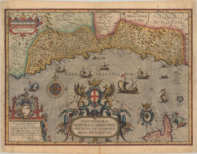
Auction 191, Lot 608
Subject: Northwestern Italy
Ortelius, Abraham
Serenissimae Reipublicae Genuensis Ducatus et Dominii Nova Descriptio, 1608
Size: 21.3 x 15.4 inches (54.1 x 39.1 cm)
Estimate: $4,000 - $4,750
One of the Rarest Maps Published in Ortelius' "Theatrum"
Unsold
Closed on 2/8/2023
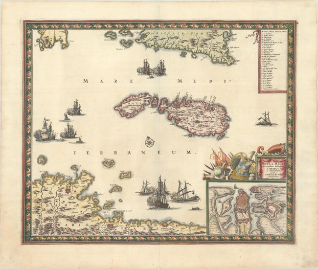
Auction 191, Lot 626
Subject: Malta
Wit, Frederick de
Insula Malta Accuratissime Delineata, Urbibus, et Fortalitiis, 1680
Size: 21.3 x 17.5 inches (54.1 x 44.5 cm)
Estimate: $1,100 - $1,400
One of the Most Decorative 17th Century Maps of Malta
Sold for: $700
Closed on 2/8/2023
Auction 191, Lot 633
Subject: Adriatic Sea & Ionian Sea
Bellin, Jacques Nicolas
Description Geographique du Golfe de Venise et de la Moree..., 1771
Size: 8.1 x 10.5 inches (20.6 x 26.7 cm)
Estimate: $2,000 - $2,300
Bellin's Complete Work on the Adriatic Sea and the Western Coasts of Greece
Unsold
Closed on 2/8/2023
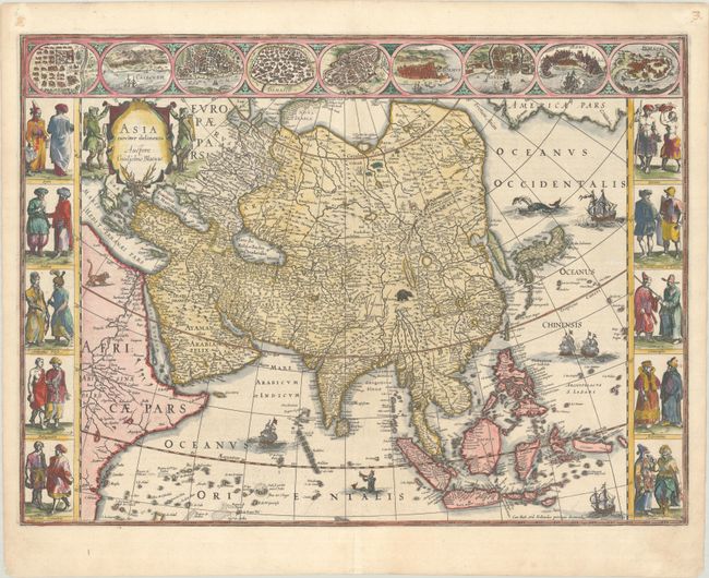
Auction 191, Lot 665
Subject: Asia
Blaeu, Willem
Asia Noviter Delineata, 1634
Size: 22.1 x 16.3 inches (56.1 x 41.4 cm)
Estimate: $3,250 - $4,000
Magnificent Carte-a-Figures Map of Asia
Sold for: $2,200
Closed on 2/8/2023
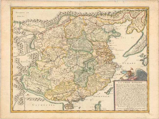
Auction 191, Lot 684
Subject: China & Korea
Sanson, Nicolas
La Chine Royaume..., 1679
Size: 21.3 x 16.4 inches (54.1 x 41.7 cm)
Estimate: $1,800 - $2,100
Important Jesuit Map of China
Unsold
Closed on 2/8/2023
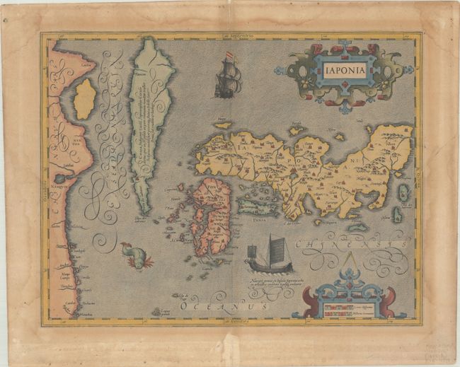
Auction 191, Lot 688
Subject: Japan & Korea
Mercator/Hondius
Iaponia, 1613
Size: 17.4 x 13.4 inches (44.2 x 34 cm)
Estimate: $1,000 - $1,300
Hondius' Richly Ornamented Map of Japan
Sold for: $750
Closed on 2/8/2023
62 lots
Page 1 of 2