Subject: Gulf of California
Period: 1747 (dated)
Publication: Noticia de la California...
Color: Black & White
Size:
11.4 x 12.5 inches
29 x 31.8 cm
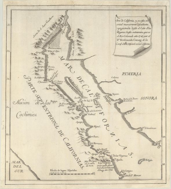
This scarce map by Fenando Consag is credited as the map that put a definitive end to the myth of the island of California. Consag (1703-59) was a Croatian Jesuit who lived in Baja Mexico from 1732 until the end of his life. In 1746, he embarked on an expedition to settle the question of California's insularity, traveling to the head of the Gulf of California and eventually reaching the mouth of the Colorado River. Consag's efforts led King Ferdinand VII to issue a royal decree in 1747 that stated in no uncertain terms that "California is not an island." Although it would take more than a hundred years after Ferdinand's decree for the island of California to completely disappear from maps, the number began to greatly decrease in the latter half of the eighteenth century.
Engraved by Joseph Gonzales, this map covers the Gulf of California from Isla Tortuga north to the Colorado River. Several interesting features are noted along the coasts, including Consag's home base, Mission San Ignacio, and a disputed claim that the Tres Virgenes volcanoes erupted in 1746, accompanied by a small illustration. The Baja region is labeled Nacion de Cochimies, a reference to the Cochimi people indigenous to the region. The land across the Gulf of California is identified as Pimeria and Sonora. It was published in Madrid in the third volume of Miguel Venegas' Noticia de la California, y de su Conquista Temporal, y Espiritual Hasta el Tiempo Presente (1757). Edited by Father Andres Marcos Burriel, the book was the first attempt at a history of California, drawing from the 1739 manuscript of Miguel Venegas as well as other contemporary sources. In addition to the map dispelling the island of California myth, the third volume also criticized the spurious De Fonte and De Fuca voyages in the northwest. We have found only a handful of examples of the map sold separately since 1985.
References: Howes #V-69; Streeter Sale #2433.
Condition: B+
A crisp impression issued folding, now flat, on paper with a coat of arms watermark. The margins have been replaced with old paper at top and bottom, with the neatline replaced in facsimile.